Capturing the hailstorm formation process involves analyzing interactions between updrafts, supercooled droplets, and atmospheric instability. We lift supercooled droplets to high altitudes where they encounter ice nuclei, forming hailstones. Strong updrafts are vital for larger hail growth, while atmospheric instability is gauged through temperature and moisture gradients. Wind shear and relative humidity also influence storm severity, and tracking synoptic-scale patterns like fronts helps identify potential hailstorm areas. Using advanced radar and satellite tools enhances our data collection capabilities. By understanding these dynamics, we gain insights that refine predictive models and improve storm warnings. Explore further to grasp the full intricacies.
Key Points
- Analyze interactions between updrafts, supercooled water droplets, and atmospheric instability for hailstone formation.
- Utilize advanced radar and Doppler technology to monitor hailstorm development in real-time.
- Monitor temperature and moisture gradients in the troposphere to evaluate atmospheric instability.
- Deploy portable weather stations and drones for high-precision atmospheric data collection.
Understanding Hailstorm Dynamics
To comprehend hailstorm dynamics, we need to analyze the interactions between updrafts, supercooled water droplets, and atmospheric instability. Hailstorm development hinges on these meteorological elements.
Updrafts within a thunderstorm lift supercooled water droplets high into the atmosphere. When these droplets encounter ice nuclei, they freeze and form hailstones. The stronger the updraft, the larger the hailstones can grow, as they remain suspended and accumulate additional layers of ice.
Atmospheric instability plays a pivotal role in the formation of these robust updrafts. We gauge this instability by evaluating temperature and moisture gradients in the troposphere. Higher instability often correlates with more intense and frequent hailstorms.
This is where storm chasing becomes invaluable. By actively engaging in storm chasing, we gather essential data on these meteorological factors in real-time, enhancing our comprehension of hailstorm dynamics.
Scientific research conducted during these pursuits allows us to refine our models and forecasts, thereby enhancing our predictive capabilities. Accurate predictions are critical for issuing timely warnings, empowering communities to take protective actions.
Essential Equipment for Chasing
When chasing hailstorms, we must prioritize both weather tracking tools and safety gear essentials. High-resolution radar systems and GPS devices enable us to pinpoint storm paths and intensity with precision.
Additionally, robust safety gear, including helmets and reinforced vehicles, secures our protection against severe weather conditions.
Weather Tracking Tools
Effective hailstorm chasing depends on our ability to deploy advanced weather tracking tools, ensuring we gather precise data and anticipate storm patterns accurately. Utilizing state-of-the-art radar technology, we can detect and analyze precipitation intensity, allowing for real-time storm prediction. Radar systems, such as Doppler radar, provide us with crucial information on storm structure, movement, and potential hail formation zones. This data empowers us to make informed decisions and adjust our chase strategies dynamically.
Satellite imagery complements radar data by offering a broader perspective on weather systems. Through high-resolution images, we monitor cloud formations, temperature variations, and moisture levels in the atmosphere. Satellites enable us to track storm development over vast areas, providing a macro view that's essential for identifying potential hailstorm triggers and tracking their evolution. Weather monitoring via satellite helps us correlate ground-level observations with atmospheric conditions, enhancing our predictive capabilities.
Combining radar technology and satellite imagery, we achieve a thorough understanding of the hailstorm formation process. These tools are vital for precise weather monitoring, enabling us to chase storms effectively and safely. As we continue our journey, these technologies will remain our steadfast allies in capturing the dynamic nature of hailstorms.
Safety Gear Essentials
Equipping ourselves with essential safety gear is paramount for safeguarding both our safety and the integrity of our data collection during hailstorm chases. Understanding the safety gear importance in the context of unpredictable weather patterns is essential.
The right equipment not only protects us but also enhances our storm chasing techniques, allowing us to capture high-quality data efficiently.
Here are three indispensable items we should never overlook:
1. Reinforced Vehicle Windshield
Hailstorms can produce hailstones large enough to shatter regular windshields. A reinforced windshield prevents glass breakage, ensuring our view remains unobstructed and our vehicle's interior stays safe.
2. Protective Helmets and Body Armor
When we're outside the vehicle, we're at risk from flying debris and large hailstones. Proper helmets and body armor safeguard us from head injuries and bodily harm, enabling us to focus on data collection without fear.
3. Weather-Resistant Communication Devices
Reliable communication is crucial during a chase. Weather-resistant radios and smartphones ensure we stay connected with our team and access real-time updates, enhancing our coordination and safety.
Identifying Storm Formation Areas
To identify storm formation areas, we analyze weather pattern indicators such as jet stream positions and pressure systems.
We focus on geographic hotspots like Tornado Alley, where conditions are ripe for severe storms.
Additionally, we assess atmospheric conditions, including humidity levels and temperature gradients, to pinpoint potential hailstorm development zones.
Weather Pattern Indicators
By analyzing atmospheric conditions, we can pinpoint areas likely to experience hailstorm formation through indicators such as temperature gradients, humidity levels, and wind shear patterns. These factors help us identify potential storm zones with a high degree of accuracy.
Key indicators include:
- Cloud Patterns and Wind Speeds: Monitoring for specific cloud formations, such as cumulonimbus clouds, and analyzing wind speeds at different altitudes can provide essential clues. The presence of strong updrafts and varied wind speeds at different atmospheric levels often indicates a conducive environment for hailstorm development.
- Temperature Fluctuations and Humidity Levels: Significant temperature discrepancies between surface air and upper atmospheric layers contribute to instability, promoting storm formation. High humidity levels further exacerbate this instability by providing the moisture needed for cloud formation and subsequent precipitation.
- Wind Shear Patterns: Wind shear, the change in wind speed and direction with altitude, is vital for hailstorm development. It supports the tilting and rotation of storm cells, maintaining the updrafts necessary for hailstone formation.
Geographic Hotspots
Having identified key atmospheric indicators, we can now pinpoint geographic hotspots where these conditions frequently converge, leading to hailstorm formation. The Great Plains in the United States, particularly 'Hail Alley' spanning from Texas to South Dakota, offer prime examples. Here, the interaction between warm, moist air from the Gulf of Mexico and cold, dry air from the Rockies creates a volatile atmosphere conducive to hailstorm formation.
To optimize our chasing strategies, understanding storm behavior in these pivotal areas is essential. Remarkably, the frequency and intensity of hailstorms are influenced by climate factors such as seasonal temperature variations and prevailing wind patterns. For instance, during spring and early summer, the differential heating of the landmass and the resultant instability heighten the likelihood of severe hailstorms.
Hailstorm prediction hinges on identifying these geographic and climatic intersections. By analyzing historical storm data and leveraging real-time satellite imagery, we can better anticipate where hailstorms will occur. This predictive capability not only aids in effective chasing strategies but also enhances public safety measures.
Atmospheric Conditions Analysis
How do we accurately analyze atmospheric conditions to pinpoint areas where hailstorms are likely to form? To tackle this, we need to focus on several key factors that drive storm formation.
Cloud formations and temperature gradients: By observing the development of cumulonimbus clouds and identifying sharp temperature differences in the atmosphere, we can predict regions of intense updrafts. These vertical movements are essential for hail formation.
Wind patterns and moisture levels: Analyzing wind shear (changes in wind speed and direction with altitude) and relative humidity helps us understand the likelihood of storm organization and severity. Higher moisture levels in the lower atmosphere contribute to the energy required for hail-producing storms.
Synoptic-scale weather patterns: Large-scale weather features, such as fronts and low-pressure systems, play a significant role in storm initiation. By monitoring these patterns, we can identify broader areas at risk for hailstorm development.
Safety Precautions for Storm Chasers
Storm chasers must prioritize safety by using reliable weather prediction tools and maintaining constant communication with team members. We should initiate a thorough risk assessment before venturing out, analyzing meteorological data from sources like Doppler radar and satellite imagery. This allows us to identify potential hazards and make informed decisions about our movements. Understanding storm dynamics and having real-time updates minimizes unexpected dangers and ensures we stay within safe zones.
Additionally, establishing detailed emergency protocols is essential. These protocols should include predefined evacuation routes, first aid procedures, and communication plans in case of network failures. We must equip our vehicles with essential emergency supplies, including medical kits, water, and non-perishable food. Satellite phones and portable weather radios provide alternative communication channels when conventional networks fail.
Our commitment to safety doesn't end with preparation; it extends to real-time operations. By assigning specific roles to each team member, we ensure that tasks like navigation, data collection, and monitoring weather conditions are covered without overlap or confusion. This structured approach allows us to focus on the primary objective—capturing accurate data on hailstorm formation—while safeguarding our well-being. Combining these safety measures empowers us to explore freely without compromising our security.
Techniques for Data Collection
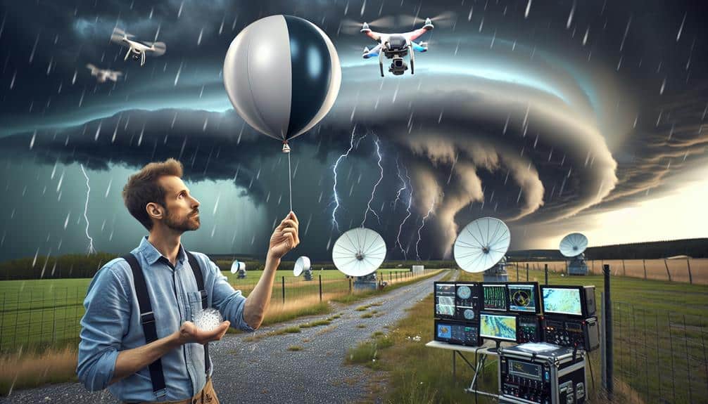
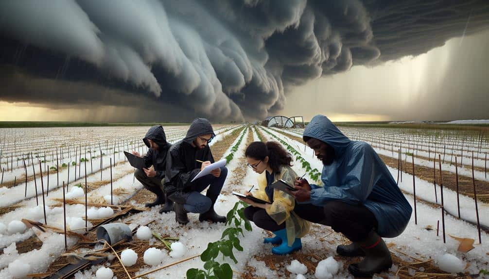
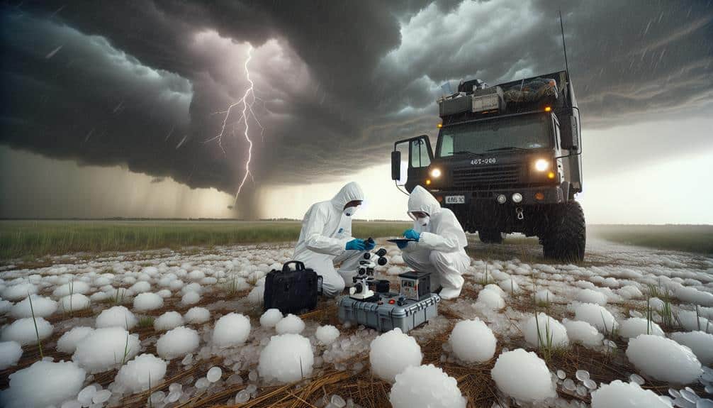
We employ a variety of high-precision instruments, such as portable weather stations and drones, to gather detailed data on hailstorm development. These tools enable us to capture real-time atmospheric conditions and provide invaluable insights into the storm's lifecycle. Our approach ensures that we can analyze a plethora of variables, such as temperature, humidity, and wind speed, with unprecedented accuracy.
To enhance our data collection, we utilize the following techniques:
- Portable Weather Stations: These compact units are strategically placed to record localized atmospheric data. They offer high temporal resolution, capturing minute-by-minute changes that are essential for understanding the dynamics of hailstorm formation.
- Drones: Equipped with advanced sensors, drones can access areas that are otherwise unreachable. They provide aerial perspectives, enabling us to collect vertical profiles of storm systems, which are vital for thorough data analysis.
- Storm Chasing: By actively pursuing developing storm cells, we can deploy mobile radars and other instruments directly into the storm's path. This hands-on approach allows us to gather firsthand data, making our observations more robust and reliable.
These techniques empower us to push the boundaries of meteorological research while embracing the freedom to explore and understand the intricate phenomena of hailstorms.
Analyzing Collected Data
Harnessing the power of advanced algorithms, we meticulously analyze the collected data to discern patterns and correlations that reveal the underlying mechanics of hailstorm formation. By employing sophisticated data interpretation methods, we can identify key variables and their interactions. Trends analysis enables us to detect recurring sequences and anomalies within the dataset, providing a clearer picture of the conditions that lead to hailstorm genesis.
We use statistical modeling to quantify these relationships, leveraging regression analysis, cluster analysis, and time-series forecasting. These models allow us to simulate various atmospheric scenarios and predict the likelihood of hailstorm occurrences with higher precision. By integrating multiple data sources—such as temperature, humidity, wind speed, and radar readings—we enhance the robustness of our predictions.
Visualization techniques play a pivotal role in our analysis. Through advanced graphical representations like heat maps, scatter plots, and three-dimensional models, we can intuitively interpret complex data sets. These visual tools not only aid in understanding but also in communicating our findings effectively to a broader audience.
Ultimately, our systematic approach to data analysis empowers us to discover deeper insights into hailstorm formation, giving us the freedom to anticipate and mitigate these natural phenomena more effectively.
Frequently Asked Questions
How Do Hailstones Vary in Size During a Hailstorm?
Hailstone growth varies wildly; some get as big as baseballs while others remain pea-sized. Atmospheric conditions, like updraft intensity and supercooled water, dictate their size. We marvel at nature's chaotic freedom during these storms.
What Role Does Climate Change Play in Hailstorm Frequency?
We're seeing an increased impact on hailstorm frequency due to climate change. Implementing mitigation strategies, such as improved forecasting and resilient infrastructure, is essential to adapt and minimize damage. Data shows a correlation between rising temperatures and storm intensity.
Can Hail Damage Be Predicted Before It Occurs?
While we can't predict hail damage with absolute certainty, advancements in hailstorm prediction and damage assessment technologies give us hope. By leveraging real-time data, we can better prepare, protect property, and guarantee our freedom from severe weather impacts.
How Do Meteorologists Name and Classify Hailstorms?
When classifying hailstorms, we use meteorological categorization based on hail size, wind speed, and storm duration. Naming conventions aren't standard for hailstorms, unlike hurricanes, focusing instead on precise, data-driven descriptions to guarantee scientific accuracy.
What Regions Are Most Prone to Severe Hailstorms Globally?
We focus on hailstorm hotspots like the Great Plains in the US, parts of Argentina, and central Asia. Our impact assessment reveals these regions face frequent, severe hail events, affecting agriculture and infrastructure in a substantial manner.