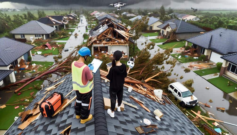
We start by obtaining permits and focusing on logistics for smooth fieldwork. Using standardized methods, we gather data via high-resolution, GPS-enabled tools for accuracy. Our process includes taking multiple angle photos, recording environmental changes, and detailed note-taking. We document weather, flora, fauna, water quality, and soil conditions precisely. Interviewing witnesses with open-ended questions guarantees detailed firsthand accounts. Finally, we categorize and interpret the data to assess damage severity and patterns. The steps we follow lead to a thorough environmental assessment, revealing deeper insights.
Key Points
- Secure necessary permits and plan logistics for efficient and standardized data collection in affected areas.
- Utilize high-resolution GPS-enabled cameras and mobile apps for real-time, accurate documentation of storm damage.
- Record environmental data, including weather conditions, species changes, and soil and water quality metrics.
- Conduct detailed witness interviews using open-ended questions and active listening to gather comprehensive information.
Preparing for Fieldwork
Before heading out to document storm damage, we must make certain that we've the necessary equipment and permits. Proper preparation is essential to guaranteeing our work is efficient and effective.
First, we need to secure all relevant permits that grant us access to the affected areas. These permits are crucial for legal and safety reasons, enabling us to conduct our assessments without any interruptions.
Next, we should focus on fieldwork logistics. This involves planning our travel routes, identifying key locations for data collection, and coordinating with local authorities and stakeholders. By doing so, we can optimize our time and resources while minimizing risks.
When it comes to data collection techniques, it's important to employ standardized methods to ensure the accuracy and reliability of our findings. We'll need to gather a variety of data, including photographs, measurements, and notes on the extent of the damage. This thorough approach allows us to create a detailed and objective assessment.
Choosing Documentation Tools
Selecting the right documentation tools is essential for accurately capturing storm damage and ensuring the reliability of our environmental assessment. Our choice of tools directly influences the quality and effectiveness of the data we gather.
First, mobile apps play an important role in real-time data collection and sharing. These apps can streamline our note-taking process by allowing us to record observations instantly and systematically. They often come with built-in features like GPS tracking, which aids in pinpointing the exact location of the damage. This functionality is vital for creating detailed and accurate maps of affected areas.
Next, robust camera equipment is indispensable. High-resolution cameras help us capture minute details that might otherwise go unnoticed. Additionally, many modern cameras integrate GPS tracking, which automatically tags the location of each photo. This feature saves time and reduces the risk of human error in logging coordinates separately.
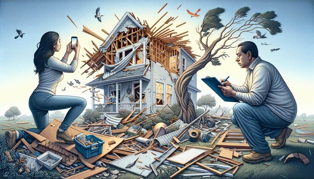
Capturing Visual Evidence
Capturing visual evidence is important for substantiating our environmental assessments and providing a clear, undeniable record of storm damage. To guarantee our damage assessment is thorough, we must focus on effective visual documentation and evidence collection through strategic photography.
First, let's remember to photograph all affected areas from multiple angles. Wide shots offer context, while close-ups highlight specific damage. When capturing images, include identifiable landmarks to provide reference points. This makes it easier for others to understand the extent and location of the damage.
Lighting plays a vital role in photography. Natural light is preferable, but if unavailable, use a flashlight or other artificial light sources to avoid shadows that could obscure important details. Additionally, timing matters. Photographing damage immediately after the storm preserves the most accurate representation of its impact.
Consistency in our approach is key. Always use the same method for each site to maintain uniformity in our visual documentation. Labeling each photograph with the date, time, and specific location ensures we've a thorough and organized collection of evidence.
Recording Environmental Data
Accurately recording environmental data is necessary for understanding the full impact of storm damage on the ecosystem. We need to adopt a systematic approach to data collection to secure our findings are reliable and actionable. Field notes play a pivotal role in this process, providing a firsthand account of the conditions immediately following the storm.
To achieve this, we should focus on the following key areas:
- Weather Conditions: Document temperature, humidity, wind speed, and precipitation. This information helps us correlate environmental changes with storm characteristics.
- Flora and Fauna: Record any visible damage to vegetation and wildlife. Note changes in species presence or behavior, which can indicate broader ecological impacts.
- Water Quality: Analyze water bodies for contaminants, turbidity, and pH levels. Storm runoff often carries pollutants that can affect local water systems.
Our field notes should be detailed and precise, capturing both quantitative measurements and qualitative observations. This thorough data collection process ensures we've a strong foundation for evaluating the storm's environmental impact, enabling us to respond effectively and maintain our freedom to thrive in a resilient ecosystem.
Interviewing Witnesses
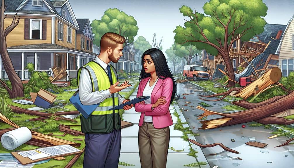
When interviewing witnesses, we must focus on identifying key individuals who observed the event.
Using effective questioning techniques, we can gather accurate and relevant information.
Recording witness statements meticulously guarantees we capture essential details for our environmental assessment.
Identifying Key Witnesses
To effectively assess storm damage, we must systematically identify and interview key witnesses who can provide firsthand accounts of the event. Identifying the right witnesses is essential to ensuring the accuracy and reliability of our environmental assessment. Using robust interview techniques and evaluating witness credibility are vital steps in this process.
Key witnesses typically include:
- Local residents: Individuals living in the affected area can provide detailed observations about the storm's impact on their surroundings.
- Business owners: Those who operate businesses in the vicinity may have documented damages and losses, offering a unique perspective on the storm's economic impact.
- Emergency responders: Firefighters, police, and medical personnel who were active during or immediately after the storm can provide professional insights and detailed reports.
Effective Questioning Techniques
Gathering detailed and reliable information from witnesses requires employing effective questioning techniques that elicit clear and thorough responses. To optimize our interviewing strategies, we must focus on open-ended questions that encourage witnesses to provide expansive answers. This approach aids in thorough evidence collection, as it allows us to gather nuanced details that might otherwise be missed.
Our communication skills play an important role in this process. By maintaining a neutral tone and avoiding leading questions, we ensure the information gathered is accurate and unbiased. Active listening is also crucial; it demonstrates to witnesses that their input is valued, which can lead to more detailed and candid responses.
Information gathering becomes more effective when we allow witnesses to narrate their experiences in their own words. We should ask follow-up questions that explore deeper into specific points, aiding in the clarification and validation of the information provided. Avoiding interruptions and showing patience can greatly enhance the quality of the data we collect.
Recording Witness Statements
Recording witness statements is a critical step in capturing accurate and thorough descriptions of storm damage. Using proper interview techniques, we can gather firsthand information that will enhance the credibility of our environmental evaluations. To begin, we must approach witnesses with sensitivity and respect, acknowledging their experiences and emotions related to the storm event.
Effective interviewing involves:
- Establishing rapport: Creating a welcoming atmosphere encourages honest and detailed responses.
- Open-ended questions: These allow witnesses to provide detailed accounts without leading them to specific answers.
- Active listening: This guarantees we fully understand the witness's account and can ask clarifying questions if necessary.
When evaluating the credibility of witness statements, we should consider the consistency of the account, the level of detail provided, and any potential biases or discrepancies. Cross-referencing statements with physical evidence or other testimonies can also help verify the information's accuracy.
Analyzing Collected Information
We start by categorizing the types of storm damage to identify patterns and prioritize areas needing immediate attention. Our data interpretation focuses on evaluating the severity and extent of damage across different regions. We analyze collected information to distinguish between structural damage, vegetation loss, and infrastructure impact. This categorization aids in a thorough damage assessment, allowing us to allocate resources effectively.
Next, we employ statistical tools to process data points from various sources, including photographs, sensor data, and witness statements. By comparing pre-storm and post-storm conditions, we can quantify the damage's impact on the environment. Geographic Information Systems (GIS) help us visualize affected areas, highlighting hotspots that require urgent intervention.
Our analysis also includes assessing the economic and ecological implications of the storm. We consider factors like agricultural loss, habitat destruction, and potential long-term environmental changes. This holistic approach ensures we not only address immediate concerns but also plan for future resilience.
Frequently Asked Questions
How Should Storm Damage Documentation Be Stored and Archived?
We should store and archive storm damage documentation using efficient data management systems and meticulous record keeping. This guarantees quick access, data integrity, and compliance with regulations, empowering us to act freely and responsibly in response to environmental challenges.
What Legal Considerations Should Be Taken Into Account When Documenting Storm Damage?
When documenting storm damage, we must guarantee legal compliance and prioritize data protection. We need to adhere to privacy laws, secure sensitive information, and maintain accurate records to avoid legal repercussions and safeguard individual freedoms.
Are There Any Specific Reporting Formats Required for Environmental Assessments?
We need to navigate the labyrinth of reporting requirements for environmental assessments. Specific formats vary, but ensuring data security and privacy protection is paramount. Let's follow the guidelines to keep our data safe and compliant.
How Can We Ensure the Privacy of Individuals Interviewed During the Assessment?
To guarantee the privacy protection of individuals interviewed, we can adopt confidential interview techniques, anonymize data, and secure information storage. These steps maintain trust and respect, allowing participants to freely share valuable insights without concerns.
What Qualifications Are Needed for Professionals Conducting Storm Damage Assessments?
Qualifications for conducting storm damage assessments are the key to accessing nature's mysteries. We need professionals with experience, expertise, training, and certifications. Their credentials guarantee accurate evaluations, empowering communities to rebuild with confidence and freedom.