You’ll enhance your storm tracking by integrating SKYWARN spotter networks with dual-polarization radar analysis, which distinguishes tornado debris signatures from precipitation. Deploy amateur radio systems and mobile cellular bonding to transmit real-time GPS-verified observations that calibrate National Weather Service warning algorithms. Target synoptic patterns featuring western U.S. troughing with southeastern ridging, analyzing MLCAPE, BWD06, and SRH01 thresholds. Your ground-truth reports reduce false radar returns while Storm Relative Mean Radial Velocity reveals internal vortex structures that transform independent observations into essential verification sensors for maximizing intercept success and warning accuracy.
Key Takeaways
- Dual-polarization radar signatures distinguish tornado debris from precipitation, improving identification of vortex development and ground-level hazards.
- Amateur radio General Class licenses enable real-time data transmission to National Weather Service via HF and VHF networks.
- Storm Relative Mean Radial Velocity analysis exposes internal wind structures, revealing rotation patterns invisible to standard Doppler displays.
- Mobile applications with cellular bonding stream live video and GPS telemetry, providing timestamped ground-truth verification to meteorologists.
- Targeting western troughing with southeastern ridging synoptic patterns maximizes tornado intercept probability during late May peak activity.
Understanding SKYWARN Spotter Training and Volunteer Networks
When the National Weather Service established SKYWARN, it addressed a critical gap between remote sensing capabilities and ground-level meteorological verification. This volunteer network collects real-time data on hail size, wind damage, tornadoes, and flash flooding—observations radar alone can’t confirm.
Storm spotter qualifications remain deliberately accessible: you’ll need to be 18 years old with telephone or amateur radio capability. No prior meteorological experience is necessary. Training program requirements include completing a free 90-minute to 3-hour course covering thunderstorm development, severe weather feature identification, and proper reporting protocols. Sessions are available in-person, virtual, or online formats, with some regions offering Spanish-language instruction.
Upon completion, you’ll receive certification without mandatory schedule notifications or vacation reporting—maintaining autonomy while contributing critical meteorological ground truth data.
Ground-Truth Reporting and Its Impact on Warning Systems
How does a tornado warning reach your mobile device within minutes of funnel cloud formation? You’re witnessing ground truth acquisition procedures in action—storm chasers providing direct observations that validate radar signatures. When you report actual funnel cloud locations via GPS coordinates, you’re supplying critical calibration data that corrects atmospheric distortion in Doppler measurements.
This ground truth data quality directly reduces errors of commission and omission in warning algorithms. Your real-time field observations enable meteorologists to distinguish between false radar returns and legitimate rotation signatures, minimizing false positives that trigger unnecessary evacuations.
Each timestamped report you submit calibrates predictive models, enhancing classification accuracy for subsequent storm cells. This decentralized verification network transforms independent observers into essential sensors, bypassing bureaucratic delays inherent in centralized forecasting systems.
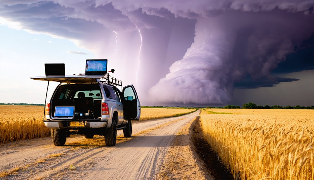
Essential Communication Tools for Real-Time Field Operations
Amateur radio networks enable you to transmit real-time observational data directly to National Weather Service offices through APRS (Automatic Packet Reporting System) protocols, bypassing congested cellular infrastructure during severe weather events.
Your General Class license (callsign format: WX0USA) grants access to HF and VHF bands for coordinated spotter networks that relay ground-truth measurements to SKYWARN operations centers.
Mobile applications now integrate cellular bonding technology to stream live video feeds and telemetry data from chase vehicles, allowing meteorologists to analyze storm structure evolution with sub-minute latency when network conditions permit.
Amateur Radio Networks Integration
During severe weather operations, storm chasers rely on amateur radio networks as their primary communication infrastructure, independent of commercial cellular systems that routinely fail under storm conditions. You’ll integrate with SKYWARN networks through local net control stations, transmitting real-time observations directly to National Weather Service operations centers.
The default simplex frequency 146.580 enables direct chaser-to-chaser coordination, while VHF repeaters provide extended coverage for critical weather reporting. Your FCC amateur license grants access to HF bands for long-distance communication when cellular data becomes unavailable.
Chaser certification programs emphasize storm spotter ethics, requiring accurate field reports transmitted through dedicated two-meter networks. This decentralized communication architecture operates without commercial dependencies, maintaining functionality during infrastructure failures while supporting coordinated emergency response efforts across affected regions.
Mobile App Transmission Capabilities
Beyond traditional radio infrastructure, mobile applications now provide storm chasers with sophisticated data transmission capabilities that operate across cellular and internet-based networks. You’ll leverage platforms like Zello for walkie-talkie-style coordination without requiring ham licenses, enabling real-time group communication across Android, iPhone, and PC devices.
Storm Chasers and Texas Storm Chasers apps integrate video streaming through Quickblox, delivering live feeds from active weather zones with optimized video feed compression techniques that preserve bandwidth during critical moments. Remote streaming reliability depends on cellular coverage, though hybrid frameworks like Ionic and Cordova guarantee cross-platform functionality.
You’ll receive push notifications covering temperature, moisture, wind velocity, and barometric pressure while accessing interactive radar overlays through Google Maps integration. AdMob-funded development cycles incorporate user feedback from 500,000+ followers, continuously enhancing field operational capabilities.
Radar Analysis Methods for Storm Development Prediction
How effectively can radar data reveal a storm’s true potential when the technology itself imposes fundamental limitations on what you observe? Understanding radar beam resolution becomes critical as earth curvature elevates your sampling height with distance, potentially overshooting mesocyclones entirely.
You’ll need dual-polarization signatures to distinguish tornado debris signatures from precipitation returns, while Doppler velocity analysis detects rotational couplets indicating vortex development. Storm Relative Mean Radial Velocity subtracts storm motion, exposing internal wind structures across multiple elevation angles.
For convective morphology tracking, systems like TITAN objectively identify and forecast thunderstorm evolution, while VCP 12‘s 4.5-minute scan cycle provides rapid vertical assessments. Phased array technology accelerates data acquisition beyond conventional WSR-88D limitations, enabling autonomous decision-making when pursuing rapidly evolving severe weather.
Identifying Optimal Synoptic Patterns for Chase Planning

When hierarchical clustering algorithms analyze 500 hPa height fields across thousands of tornado events, they reveal four distinct synoptic regimes that fundamentally determine chase success. You’ll maximize intercepts by targeting synoptic pattern climatology featuring western U.S. troughing coupled with southeastern ridging—this configuration drives the classic Four-Corners-to-Plains jet trajectory.
Ideal environment thresholds demand MLCAPE exceeding 2000 J/kg, BWD06 above 40 knots, and SRH01 surpassing 150 m²/s². Your upper-level setup requires due west 500 mb flow with strong differential vorticity advection, while surface features need slow-moving cyclones and robust 850 mb southerly flow exceeding 30 knots.
Amplified patterns with deep troughs sustain multi-day outbreak potential. Late May in Kansas statistically delivers peak tornado metrics when these atmospheric ingredients align—prioritize this climatological window for maximum chase freedom.
Mobile Applications for Advanced Weather Data Access
You’ll need sophisticated mobile applications that integrate NEXRAD and TDWR radar networks with real-time overlay capabilities to visualize mesocyclone development and precipitation cores during active chases.
These platforms transmit critical data through cellular networks and satellite connections, ensuring continuous access to velocity products and reflectivity data even when operating in areas with limited infrastructure.
Your chase vehicle should maintain multiple data transmission pathways, as remote terrain often requires redundant connectivity solutions to sustain uninterrupted access to high-resolution radar feeds and National Weather Service Doppler products.
Real-Time Radar Overlay Features
Modern storm chasing applications leverage sophisticated radar overlay systems that integrate multiple meteorological data streams into unified visualization platforms. You’ll access high-resolution NOAA data with five-minute refresh intervals, enabling precise radar reflectivity interpretation critical for identifying precipitation intensity and storm structure.
Advanced layers incorporate wind streams, lightning strikes, hail probability zones, and tropical system trajectories—all rendered through intuitive Mapbox interfaces. These platforms deliver predictive storm modeling extending 72 hours domestically, empowering autonomous decision-making during pursuits.
Real-time lightning data overlays combine with National Weather Service alerts, while 24-hour rewind capabilities let you analyze storm evolution patterns. Interactive controls allow customization of radar layers for tornadoes, hurricanes, and cyclones, giving you unrestricted access to professional-grade meteorological intelligence previously limited to institutional forecasters.
Remote Area Data Transmission
Radar visualization platforms deliver critical intelligence only when chasers maintain reliable connectivity to data streams, particularly in remote terrain where storms frequently intensify. You’ll need multi-modal transmission systems combining GSM/4G for instant field deployment, LoRa for kilometers-range coverage in isolated territories, and satellite links ensuring seamless data sharing from harsh environments.
Low latency transmission protocols like TCP/IP guarantee error-free packet delivery while adaptive communication pathways automatically switch between wireless and wired options when signal interference occurs. Deploy redundant channels—pair cellular telemetry with GOES 15-minute transmissions for backup reliability.
Cloud platforms enable real-time mobile access to streaming meteorological data, while Bluetooth verification confirms sensor accuracy pre-deployment. Solar-backed power systems maintain 365×24 uptime during prolonged severe weather events, preserving your operational autonomy in critical chase scenarios.
Strategic Positioning in Prime Chase Terrain
Where should you position yourself to maximize intercept probability while minimizing risk exposure during active chase operations? Triple points—where dry lines, warm fronts, and cold fronts converge—offer peak lift convergence and low-level shear vorticity for tornado development. However, terrain access coordination demands satellite imagery analysis of road networks before deployment.
Arrive one hour pre-initiation for data reanalysis and boundary adjustments. Position southeast of anticipated tornado paths; approach from west, south, or east vectors—never north. Maintain multiple escape routes throughout operations. Strategic visual monitoring requires pre-selected viewing locations via street view reconnaissance.
Northeast terrain necessitates early road commitments due to constrained networks and population-center impediments. Balance forecast quality against accessible infrastructure. Depart crowded convergence zones proactively to gain positioning advantages over reactive chasers.
Integrating Multi-Source Data Streams for Decision Making
Ideal chase positioning means nothing without real-time intelligence to guide your intercept decisions. Multi-source data integration transforms disparate information streams—radar returns, satellite imagery, mobile mesonet observations, and AI-processed video feeds—into actionable forecasts. MRMS systems update every two minutes, providing four-dimensional storm structure analysis that eliminates single-radar heartbeat effects.
You’ll achieve superior results through data source prioritization: radar vortex signatures carry higher confidence weights than distant satellite indicators, while machine learning forecasting models process storm chaser videos to detect funnel formations. Mobile systems receive S-Band satellite feeds, combining wind-shear algorithms with GPS precision. Your aggregated data generates confidence-scored alerts, plotting trajectories despite radar sweep delays.
This autonomous intelligence network empowers split-second decisions when seconds determine successful intercepts versus missed opportunities.
Frequently Asked Questions
What Safety Equipment Should Storm Chasers Carry Beyond Communication Devices?
You’ll need protective gear including helmets, hail-resistant goglesses, and reflective vests. Essential equipment includes portable flashlights for low-visibility operations, spare tire supplies for puncture mitigation, extensive EMS kits, and vehicle extraction tools enabling autonomous field mobility.
How Do Lightning Detection Networks Complement Radar Data During Active Chases?
Like telegraph operators tracking storms, you’ll receive real-time lightning data identifying convective initiation and intensity changes radar misses. Storm evolution analysis through flash rates, polarity patterns, and in-cloud activity enhances your situational awareness and warning lead time considerably.
What Fuel Range Is Recommended for Vehicles in Remote Chase Territories?
You’ll need 600-mile range minimum for remote chase territories. Fuel efficiency considerations demand vehicles achieving 15+ mpg highway, while remote refueling strategies require topping off at every town since station gaps reach 50 miles across western plains.
How Do Storm Chasers Handle Medical Emergencies in Isolated Rural Areas?
You’ll apply first aid training to stabilize victims using emergency kits, then coordinate emergency evacuation procedures with local authorities. Your real-time communication provides critical situational data, bridging response gaps until professional medical teams reach remote locations.
What Backup Power Solutions Work Best for Extended Field Operations?
Like a nomad traversing endless deserts, you’ll need portable generators paired with solar power banks. This dual-system architecture provides redundant energy streams, delivering 500-3000W continuous output while maintaining operational autonomy across multi-day deployments in grid-isolated environments.

