When you study supercell storms historically, you’re examining systems that broke every measurable benchmark. The 2011 Super Outbreak produced 360+ tornadoes across 21 states, killing 324 people and generating $11 billion in damages. Other defining events include the Campo CO supercell’s textbook mesocyclone, the Monster Supercell’s seven tornado touchdowns, and the Flint Hills storm’s cyclic vortex behavior. Each storm’s atmospheric data tells a story that rewards closer examination.
Key Takeaways
- The 2011 Super Outbreak produced over 360 tornadoes across 21 states, causing 324 fatalities and $11 billion in damages.
- Historic supercells are defined by rotating updrafts, persistent mesocyclones, and their ability to generate violent, long-track tornadoes.
- The Campo CO supercell demonstrated textbook high-plains dynamics, with Doppler data showing gate-to-gate shear exceeding 100 knots.
- The “Monster Supercell” produced seven tornado touchdowns from a single storm, remaining nearly stationary for hours.
- The Flint Hills supercell produced a green-tinted sky from deep hail cores, generating multiple EF2-EF3 tornadoes.
What Makes a Supercell Storm Truly Historic?
When measuring what makes a supercell storm truly historic, meteorologists and researchers focus on a convergence of quantifiable factors: tornado count, track length, wind speed, fatalities, and economic damage.
Historic supercells are measured by tornado count, track length, wind speed, fatalities, and economic damage.
You’ll find that supercell characteristics—rotating updrafts, persistent mesocyclones, and organized storm formation—separate ordinary thunderstorms from record-breaking events. Historic supercells don’t just produce one tornado; they generate families of violent, long-track twisters across multiple states.
The 2011 Super Outbreak exemplifies this benchmark, delivering 360+ tornadoes, EF5 intensity, 210 mph winds, 324 fatalities, and $11 billion in damage across four days.
Data drives these classifications. When you analyze storm records objectively, you’re recognizing that duration, intensity, and geographic scale collectively define whether a supercell earns its place in meteorological history.
The 2011 Super Outbreak: America’s Deadliest Supercell Event
When you examine the 2011 Super Outbreak, you’re confronting the largest tornado outbreak in U.S. history, with over 360 tornadoes tearing across 21 states in just four days.
You can trace 324 fatalities and $11 billion in damage directly to the event’s multiple supercells, each capable of sustaining long-track, violent tornadoes simultaneously.
One EF5 tornado alone carved an 80-mile path through Alabama at 210 mph winds, illustrating the outbreak’s catastrophic efficiency at converting atmospheric energy into destruction.
Outbreak’s Unprecedented Tornado Count
Over 360 tornadoes tore across 21 states in just four days during the 2011 Super Outbreak, making it the largest tornado outbreak in U.S. history by raw tornado count.
Understanding the tornado dynamics and supercell structure behind this event reveals why containment was impossible:
- Multiple discrete supercells maintained simultaneous rotation across hundreds of miles, overwhelming any coordinated response.
- Long-track tornadoes persisted for dozens of miles due to sustained low-level wind shear feeding each mesocyclone.
- Atmospheric instability exceeded 4,000 J/kg CAPE, fueling explosive supercell development repeatedly throughout the outbreak.
You’re looking at an event where nature’s mechanics operated beyond historical precedent.
The data doesn’t lie — this outbreak redefined baseline expectations for severe weather preparedness and fundamentally changed how meteorologists model large-scale convective outbreaks.
Catastrophic Fatalities And Damage
The sheer scale of the 2011 Super Outbreak‘s tornado count set the stage for an equally staggering human and economic toll.
You’re looking at 324 confirmed fatalities and $11 billion in damage — figures that expose critical gaps in tornado preparedness across affected communities.
Alabama bore the heaviest losses, where a single EF5 tornado cut an 80-mile path at 210 mph winds.
Storm photography from that day documents devastating structural failures across entire neighborhoods, providing researchers with analytical data to refine damage assessment models.
These images aren’t merely visual records; they’re technical evidence driving policy reform.
When you examine the economic distribution of losses across 21 states, it’s clear that inadequate preparedness infrastructure amplified what meteorological violence alone couldn’t fully explain.
Violent Long-Track Tornadoes
During the 2011 Super Outbreak, multiple supercells didn’t just produce tornadoes — they sustained them across extraordinary distances, creating long-track events that overwhelmed emergency response timelines.
Understanding tornado dynamics here reveals why these storms were uniquely destructive:
- A single EF5 tornado traveled 80 miles through Alabama, maintaining 210 mph winds driven by sustained supercell structure and exceptional low-level shear.
- Persistent mesocyclone organization allowed supercells to continuously cycle, regenerating tornadoes rather than dissipating after initial touchdowns.
- Deep tropospheric wind profiles provided uninterrupted energy, locking supercell structure into violent mode for hours.
You’re looking at systems that didn’t behave predictably — they exploited atmospheric conditions methodically.
Recognizing these tornado dynamics gives you critical insight into why 324 fatalities occurred despite modern warning infrastructure being fully operational.
Campo CO Supercell: The Most Perfectly Structured Tornado on the High Plains
When you analyze the Campo CO supercell, you’re examining a textbook high-plains thunderstorm that combined low dewpoints, strong wind shear, and elevated mixed-layer instability to produce near-ideal classic supercell structure.
You can track the storm’s intensifying rotation through photographs that captured a visually striking wall cloud and mesocyclone with exceptional organizational clarity, drawing storm chasers who recognized its structural rarity.
The supercell’s extreme updraft dynamics sustained the wedge tornado across an extended period, a persistence driven by consistent inflow and minimal storm-relative environmental wind interference.
Classic High Plains Formation
Few storm systems in modern meteorological documentation rival the structural precision of the Campo, Colorado supercell, a textbook example of classic high-plains formation that drew chasers from across the country for its rare atmospheric geometry.
Its supercell characteristics delivered unobstructed visibility across flat terrain, revealing every stage of the tornado lifecycle with unusual clarity.
Three defining formation elements stood out:
- Anvil structure — A crisp, expansive anvil crown confirmed extreme upper-level divergence driving sustained updrafts.
- Wall cloud development — A sharply defined, rotating wall cloud descended well below the mesocyclone base.
- Inflow organization — Powerful boundary-layer inflow fed the updraft continuously, sustaining rotation for an extended period.
You’re witnessing pure atmospheric mechanics — no interference, no compromise, just raw supercell precision executing exactly as thermodynamic conditions demanded.
Intense Rotation Captured
What the formation sequence established in structure, the rotation signatures confirmed in violence. As you analyze the Campo CO supercell’s rotational dynamics, you’re witnessing mesocyclone intensification rarely documented with such precision.
Doppler data revealed gate-to-gate shear exceeding 100 knots, confirming violent low-level rotation beneath that iconic wall cloud.
You can track the visual phenomena directly: the condensation funnel tightened progressively as inflow accelerated, while the rotating base exhibited textbook cyclostrophic balance.
Chasers recorded sustained tornado contact spanning extended periods, with extreme updrafts maintaining structural integrity throughout the lifecycle.
The anvil’s glaciated crown and the wedge tornado’s ground-scraping width told parallel stories simultaneously — atmospheric instability translated directly into organized, persistent rotation you could measure, photograph, and analyze with remarkable scientific clarity.
Extended Tornado Sustains
The extended sustain of the Campo CO tornado stands as one of the high plains’ most analytically significant events, with extreme updraft velocities maintaining structural coherence across a duration that defied typical lifecycle expectations.
You’re examining tornado longevity driven by precise atmospheric alignment. Storm dynamics here operated at peak efficiency, enabling continuous vortex maintenance.
Three critical factors sustained this tornado:
- Low-level wind shear provided consistent rotational energy input
- Moisture flux convergence continuously fueled the mesocyclone’s intensification
- Minimal entrainment disruption preserved core structural integrity
These variables combined to produce measurable vortex stability far exceeding standard supercell outputs.
You can analyze this event as a benchmark case, where atmospheric conditions aligned with near-perfect precision, delivering exceptional tornado longevity across Colorado’s open terrain.
Rolling Danger: Mesocyclone, Baseball Hail, and Lightning Over the Open Plains
Among the most visually striking supercells ever documented, the Rolling Danger storm combined baseball-sized hail, a photogenic mesocyclone, and vivid lightning into a single, prolonged meteorological event over the open plains.
You’re witnessing mesocyclone dynamics at their most intense — rotating updrafts exceeding 100 mph sustaining deep, persistent rotation within a classic supercell structure.
Hail formation accelerated as supercooled water droplets cycled repeatedly through the storm’s powerful updraft, accumulating ice layers until gravitational force overcame lift. The result: baseball-sized projectiles descending at destructive terminal velocities.
Time-lapse footage captures the storm’s dramatic rolling base evolving over hours, while vivid lightning illuminated the dark, precipitation-laden core.
The Midwest terrain offered no obstruction, allowing the mesocyclone to maintain rotational integrity and deliver a prolonged, visually compelling, meteorologically significant event.
Flint Hills Invasion: The Supercell That Turned Kansas Green and Violent
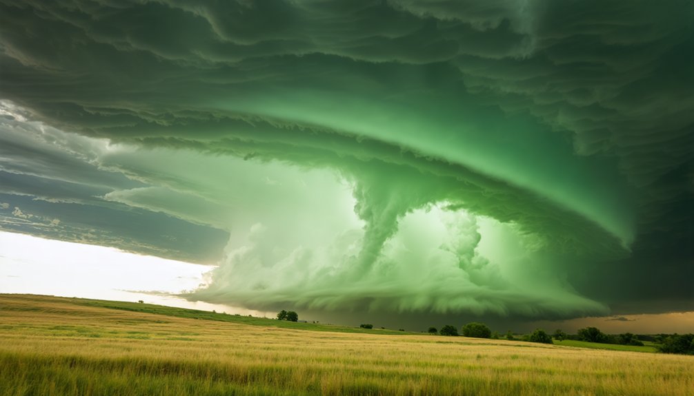
When a supercell invaded Kansas’s Flint Hills region, it announced its presence through one of nature’s most unsettling visual cues: a green-tinted sky produced by deep hail cores scattering sunlight across the storm’s precipitation-laden interior.
You’re witnessing tornado formation driven by measurable physics:
- Multiple vortices emerged from a cyclic mesocyclone rotating at documented intensities.
- EF2-EF3 tornadoes carved paths through the Flint Hills’ open grasslands.
- Green-tinted rotation confirmed heavy precipitation embedding within the updraft column.
This supercell didn’t just threaten — it delivered. The towering cumulonimbus reached extreme altitudes while funnel clouds multiplied beneath a churning base.
The scenic Flint Hills backdrop amplified every rotation visually, giving chasers dramatic documentation of violent tornado formation cycles unfolding across one of America’s most iconic landscapes.
Hico Supercell: Golf Ball Hail, Inflow Jets, and Nocturnal Lightning
Near Hico, Texas, a supercell delivered one of the more technically compelling storm signatures documented in the region — golf ball-sized hail cores, high-speed low-level inflow jets, and shelf cloud formation compounding the threat profile simultaneously.
You’d observe the Hico Supercell Features through measurable inflow acceleration, where boundary-layer convergence fed sustained rotation directly into the mesocyclone.
Tornado Formation occurred amid brief but structured touchdowns, each tied to discrete mesocyclone cycling rather than random convective bursts.
As the system persisted into evening hours, nocturnal lightning illuminated the rotating base, giving storm analysts rare visual confirmation of continued low-level wind shear.
The data captured here — hail size, inflow velocity, rotation depth — represents exactly the kind of unfiltered atmospheric evidence that expands independent meteorological understanding beyond institutional frameworks.
Monster Supercell: One Storm, Seven Tornadoes, One Long Day

Seven tornado touchdowns in a single day from one storm system isn’t a statistical anomaly — it’s the signature of a cyclic mesocyclone operating at peak performance. This Monster Supercell‘s storm structure allowed continuous tornado formation through repeated mesocyclone cycling, fundamentally resetting its rotational engine each time.
What made this system extraordinary:
- It sat nearly stationary for hours, concentrating energy over a single corridor.
- Its cyclic mesocyclone regenerated vortices systematically rather than randomly.
- Baseball-sized hail and torrential rain confirmed extreme thermodynamic instability.
You’re watching atmospheric mechanics execute with brutal precision. Each tornado reflected deliberate storm structure dynamics — not chaos.
Understanding cyclic tornado formation means recognizing that one supercell, given ideal conditions, becomes a sustained, efficient, and relentless tornado-producing machine you can’t ignore.
Frequently Asked Questions
Can Supercell Storms Occur During Winter Months in the United States?
Yes, you can witness winter supercells forming across the U.S. South and Plains. Cold-season storm formation occurs when strong wind shear interacts with moisture, enabling winter supercells capable of producing tornadoes even in December through February.
How Do Storm Chasers Legally Access Private Land During Supercell Events?
You don’t have automatic land access rights during supercell events. You must secure storm permissions from landowners beforehand or stay on public roads. Trespassing laws still apply, so you’re legally obligated to respect private property boundaries always.
What Psychological Effects Do Survivors Commonly Experience After Supercell Tornado Events?
After surviving a storm that’s shattered your entire world, you’ll face intense survivor trauma, including PTSD, anxiety, and depression. Recovery challenges demand you actively rebuild mental resilience through therapy, community support, and structured psychological intervention protocols.
How Do Insurance Companies Specifically Classify and Process Supercell Storm Damage Claims?
When you file supercell damage claims, insurers conduct thorough damage assessment, verify policy coverage, require detailed claim documentation, and calculate precise loss estimation using wind speed data, structural reports, and meteorological records to determine your payout.
Are There International Supercell Storms Comparable in Scale to U.S. Outbreaks?
Yes, you’ll find international supercell comparisons revealing that global storm patterns show Bangladesh, Argentina, and Australia produce comparable violent supercells, though they’re less documented than U.S. outbreaks due to limited meteorological infrastructure and sparse population data.
References
- https://www.youtube.com/watch?v=yvIKIgelY6g
- https://www.youtube.com/watch?v=rqxMRBWTcE8
- https://iso.500px.com/10-craziest-supercells-on-500px-because-storms-are-awesome/


