We tackle hailstorm research and analysis by focusing on five key guidelines. First, we analyze meteorological data like temperature, humidity, wind speed, and atmospheric pressure to understand storm formation. Second, we utilize advanced radar and satellite technology for precise monitoring. Safety protocols, including real-time updates and protective gear, form our third guideline. Fourth, data collection employs ground sensors and aerial surveillance for high-resolution insights. Finally, we analyze historical patterns to identify trends and hotspots. By following these guidelines, we enhance our predictive capabilities and risk mitigation strategies for hailstorms, with deeper insights to come.
Key Points
- Utilize advanced radar and satellite technology for precise monitoring and prediction of hailstorm formation.
- Implement robust safety protocols, including evacuation plans and protective gear, to ensure researcher safety during field studies.
- Analyze historical hailstorm patterns to identify trends, hotspots, and correlations with climatic variables.
- Employ ground-based sensors, aerial surveillance, and Doppler radar for high-resolution data collection on hailstone properties and storm paths.
Understanding Meteorological Data
To effectively analyze hailstorm phenomena, we must first investigate the complexities of meteorological data, which includes variables such as temperature, humidity, wind speed, and atmospheric pressure. Understanding temperature fluctuations is critical, as they play a pivotal role in storm formation. We can identify the specific conditions that lead to hailstorm development by closely monitoring how temperature varies with altitude.
Next, atmospheric pressure provides insights into the dynamics of storm systems. High and low-pressure zones influence wind patterns and subsequently impact the severity and trajectory of hailstorms. We must analyze these pressure changes to predict storm movement accurately.
Examining precipitation patterns is also essential. By tracking rainfall, sleet, and hail, we can discern the stages of storm development. This helps us understand the transformation from initial cloud formation to mature hail-producing systems.
Combining this data, we establish a thorough weather profile that identifies potential hailstorm threats. This knowledge empowers us to anticipate and respond to severe weather, affording us greater freedom to take preventative measures.
Equipment and Technology
Utilizing advanced radar systems and satellite technology, we can precisely monitor hailstorm formation and progression in real-time. These tools enable us to gather high-resolution data through remote sensing, providing critical insights into storm dynamics.
Doppler radar, a cornerstone of our arsenal, facilitates detailed radar analysis by measuring the velocity and reflectivity of precipitation particles. This data helps us identify potential hail cores and estimate hail sizes with remarkable accuracy.
Moreover, satellite technology plays a pivotal role in capturing large-scale atmospheric phenomena. Geostationary satellites, for instance, offer continuous observation capabilities, allowing us to track storm development over vast regions. By integrating satellite imagery with ground-based radar data, we achieve a thorough understanding of hailstorm behavior.
Our approach isn't just about data collection; it's about data integration and analysis. Advanced algorithms process this extensive amount of data, identifying patterns and anomalies that could signify severe weather events. This level of precision empowers us to make informed decisions and provide timely warnings to affected areas.
In essence, the synergy between radar systems and satellite technology enhances our ability to study hailstorms, paving the way for more accurate predictions and greater freedom from unexpected weather hazards.
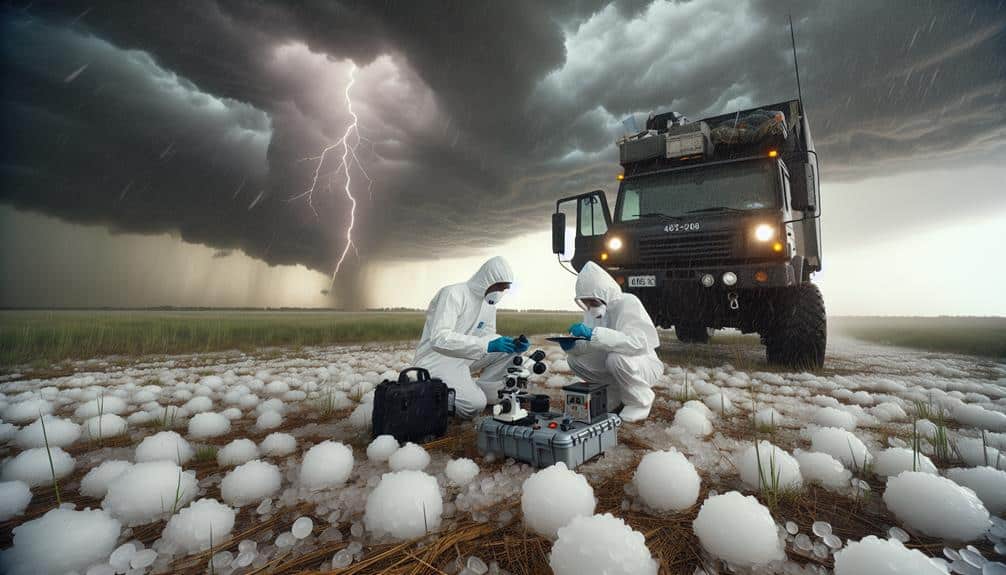
Safety Protocols
Ensuring the safety of our research teams during hailstorm investigations involves strict adherence to meticulously developed protocols and real-time monitoring of weather conditions. By prioritizing safety, we empower our teams to navigate the inherent risks of hailstorm research while maximizing data integrity and operational efficiency.
Firstly, we implement thorough emergency procedures:
- Evacuation Plans: We establish clear evacuation protocols tailored to each research site, ensuring swift and orderly exits.
- Communication Systems: Robust communication networks are maintained to provide real-time updates on weather conditions and team locations.
- First Aid Preparedness: All team members are trained in first aid, and kits are readily available to address potential injuries immediately.
- Incident Reporting: A structured incident reporting system is in place to analyze and mitigate risks continuously.
Additionally, the use of appropriate protective gear is non-negotiable. Helmets, reinforced clothing, and safety goggles are standard issue to safeguard against hail impact. We also utilize radar and satellite data to anticipate hailstorm developments, allowing preemptive action.
Data Collection Techniques
With a combination of ground-based sensors and aerial surveillance, we systematically capture high-resolution data on hailstorm dynamics. Our approach involves deploying an array of advanced meteorological instruments, including Doppler radar and hailpads, to measure hailstone size, velocity, and distribution in real-time. These ground-based sensors provide granular data that's essential for understanding the microphysical properties of hailstorms.
Simultaneously, we employ aerial surveillance techniques such as drones equipped with high-definition cameras and LIDAR systems. These tools offer a bird's-eye view, allowing us to map hailstorm paths and intensity with unprecedented precision. By integrating data from these sources, we enhance our predictive models and make more informed decisions.
Satellite imagery plays a vital role in our data collection framework. High-resolution images from geostationary and polar-orbiting satellites enable us to monitor large-scale weather patterns and identify hailstorm formation zones. This satellite data, when cross-referenced with ground and aerial observations, provides a holistic view of hailstorm dynamics.
We also leverage case studies from past hailstorm events to refine our data collection techniques continually. Analyzing detailed reports and datasets from these case studies helps us optimize sensor placement and improve data accuracy, ensuring we stay ahead in the field of hailstorm research.
Analyzing Historical Patterns

Over the past decades, we've meticulously analyzed historical hailstorm data to identify recurring patterns and trends. By employing advanced trend analysis techniques, we can discern shifts regarding the frequency and severity of extreme events. This data-driven approach enables us to pinpoint how regional impacts differ and how climate change may be influencing these destructive occurrences.
Our analysis involves several critical components:
- Temporal Trends: We examine the temporal distribution of hailstorms to detect any significant changes over time, noting increases or decreases in occurrence.
- Geospatial Patterns: Mapping hailstorm events allows us to identify hotspots and regions more prone to extreme events, providing insights into regional impacts.
- Severity Metrics: By quantifying hailstorm intensity, measured through hail size and damage, we can assess whether storms are becoming more severe, likely due to climate change.
- Correlation with Climatic Variables: We investigate correlations between hailstorm data and specific climatic variables, such as temperature and atmospheric pressure, to understand the broader climate change implications.
Analyzing historical patterns not only illuminates past and present hailstorm behaviors but also equips us with the foresight needed to mitigate future risks. This proactive stance aligns with the audience's desire for freedom, seeking to anticipate and adapt to the challenges posed by extreme weather events.
Frequently Asked Questions
How Can Community Involvement Enhance Hailstorm Research?
Did you know 70% of hail data comes from citizen scientists? By leveraging community engagement and fostering research collaboration, we enhance data collection accuracy and deepen our understanding of hailstorm patterns, empowering us with valuable insights.
What Are the Economic Impacts of Hailstorms on Agriculture?
The economic impacts of hailstorms on agriculture are significant. We see substantial crop damage and financial losses. By implementing mitigation strategies and building resilience, we can better protect our livelihoods and maintain financial freedom.
How Do Insurance Companies Assess Hailstorm Damage Claims?
When a hailstorm hits, insurance companies act like detectives. They use claim evaluation, data analysis, and adjuster training to assess damage. A well-trained adjuster can save farmers' livelihoods by accurately evaluating crop damage and processing claims efficiently.
What Role Do Climate Change Models Play in Predicting Future Hailstorms?
We utilize climate change models to enhance predictive accuracy for future hailstorms. By analyzing vast datasets, we refine our projections, providing essential insights that empower us to take proactive measures and mitigate potential hailstorm impacts effectively.
How Can Public Awareness Campaigns Mitigate Hailstorm Risks?
Imagine the power of knowledge—public awareness campaigns can effectively mitigate hailstorm risks. By involving the community and enhancing research, we transform data into action, fostering a culture of preparedness and proactive risk mitigation.