We leverage exact hailstorm data analysis to enhance insurance evaluations and mitigate financial risks. We use historical weather patterns, satellite imagery, and on-site sensors to inform decision-making on potential damages. We guarantee the reliability of our data with advanced radar systems and high-definition cameras. Accurate hail measurements are captured using calibrated instruments like hail pads and sound sensors. By employing remote sensing technologies and machine learning algorithms, we assess damage patterns and structural vulnerabilities. Our analytical approach aids in identifying trends and anomalies essential for thorough risk assessment. Learn about our full methodology and tools at your disposal.
Key Points
- Historical weather data analysis aids in predicting hailstorm risk and estimating potential damage.
- Accurate hail measurements from calibrated instruments enhance the reliability of insurance assessments.
- Remote sensing and on-site inspections provide comprehensive damage evaluation for insurance claims.
- Structural vulnerability assessments identify weak points and potential failure in building materials.
Importance of Hailstorm Data
Understanding the importance of hailstorm data is vital for accurately evaluating insurance claims and mitigating financial risks. By leveraging data analysis, we can make informed decisions that enhance our ability to assess potential damages and predict future hailstorm events. This allows insurance companies to allocate resources more efficiently and offer more precise premiums to customers.
Data analysis involves collecting and scrutinizing large datasets from historical weather patterns, satellite imagery, and on-ground sensors. By examining these datasets, we identify trends and anomalies that contribute to our overall risk assessment. For instance, analyzing the frequency and intensity of past hailstorms helps us anticipate the likelihood of similar events occurring.
Furthermore, risk assessment is pivotal in this context. We evaluate the probability of hailstorm events and their potential impacts on various regions. This involves creating sophisticated models that account for variables like climate change, geographic features, and seasonal variations. Accurate risk assessment not only aids in setting fair insurance premiums but also helps in developing strategies for risk mitigation.
Choosing Reliable Equipment
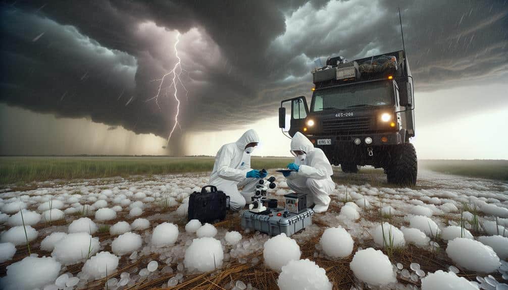
Selecting the right equipment is important for accurate hailstorm data collection and subsequent insurance assessment. We need precision instruments to reliably measure hail size, density, and distribution. For that, equipment maintenance and calibration accuracy are paramount. Regularly maintaining our tools ensures they remain in top condition, reducing the risk of data inaccuracies.
Calibration accuracy, on the other hand, guarantees that our measurements are consistently reliable, which is vital for data interpretation and validation. We use advanced radar systems, hail pads, and high-resolution cameras to capture detailed data. These tools must be meticulously calibrated to detect variations in hailstone size and frequency. Properly calibrated equipment helps us avoid errors during data interpretation, leading to more dependable insurance assessments.
Data validation is another important aspect. Cross-checking our data with multiple sources improves its credibility. For instance, combining radar data with ground-based observations enables us to paint a more precise picture of the hailstorm's impact.
Safety Precautions for Storm Chasers
Securing the safety of our storm chasers necessitates a thorough understanding of weather patterns, robust communication systems, and rigorous adherence to established safety protocols. To effectively mitigate risks, we must continually analyze meteorological data. This includes tracking storm cells and predicting hail trajectories using Doppler radar and satellite imagery. By doing so, we can anticipate hazardous conditions and adjust our chase plans accordingly.
Chase etiquette is paramount. We respect local laws and maintain a safe distance from fellow chasers and emergency responders. This guarantees we don't impede rescue operations or endanger ourselves and others. Equipment maintenance is another critical aspect. Regularly inspecting and calibrating our weather instruments, GPS units, and communication devices guarantees they're operational when we need them most.
Emergency preparedness can't be overstated. Each chase team should have a detailed emergency plan, including designated meeting points and communication protocols. Additionally, carrying first aid kits, fire extinguishers, and other emergency supplies is essential. By adhering to these precautions, we can balance our quest for data with the freedom and safety we cherish.
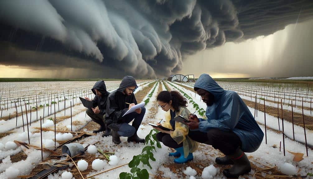
Collecting Accurate Hail Measurements
Accurately capturing hail measurements hinges on deploying calibrated instruments such as hail pads, high-resolution cameras, and acoustic sensors. These tools are paramount in enhancing measuring accuracy, enabling us to obtain precise data essential for insurance assessments.
Hail pads, typically made of Styrofoam, capture the impact craters formed by hailstones, allowing us to analyze their size and distribution. High-resolution cameras, strategically placed, photograph hailstones in real-time, providing visual data that can be further analyzed for dimensional accuracy.
Our data collection techniques don't stop there. We employ acoustic sensors to detect and record the impact sounds of hailstones, converting these acoustic signatures into measurable data. This multi-faceted approach guarantees a robust dataset, minimizing errors and maximizing reliability.
By cross-referencing data from different sources, we can validate our findings and improve the overall measuring precision. Moreover, we utilize GPS-enabled devices to geo-tag hail events, ensuring our data is spatially accurate. This geospatial information is essential for mapping hailstorm patterns and understanding their geographical impacts.
Analyzing Hailstorm Impact

Let's start by examining damage detection methods. These methods involve using remote sensing technology and ground-based inspections to quantify hail-induced damage.
We can then assess structural vulnerability by analyzing material properties, construction techniques, and historical damage data. This approach will enable us to generate accurate risk assessments and improve predictive models for future hailstorm events.
Damage Detection Methods
To effectively evaluate hailstorm damage, we utilize advanced remote sensing technologies and on-site inspections to gather detailed data on impact severity. By combining these methods, we ensure a thorough analysis that leverages both high-tech and hands-on approaches.
Remote sensing allows us to cover vast areas quickly and efficiently. Using satellite imagery and drone-based photogrammetry, we can identify subtle surface changes caused by hail impact. These data sets are then processed using machine learning algorithms to recognize and measure damage patterns.
On-site inspections are equally crucial. Trained professionals assess hail damage directly, providing ground-truth data to validate remote sensing findings. This hybrid approach maximizes accuracy and minimizes oversight.
Here are the key methods we employ:
- Satellite Imagery Analysis: Utilizes high-resolution images to monitor large-scale damage.
- Drone-Based Photogrammetry: Captures detailed 3D models of affected areas.
- Machine Learning Algorithms: Processes image data to detect and quantify hail damage.
- Ground-Truth Inspections: Validates remote sensing data through direct observation.
Assessing Structural Vulnerability
Building on our thorough damage detection methods, we now focus on evaluating structural vulnerability by analyzing the specific impact of hailstorms on various building materials and architectural designs.
Our analytical approach starts with systematic building inspections, appraising each component's material durability. By quantifying the hail's kinetic energy and correlating it with material performance, we can predict which structures are most susceptible to damage.
We utilize high-resolution impact simulations and real-world data to identify weak points in roofing, siding, and windows. For instance, asphalt shingles might show varied resistance levels based on thickness and composite materials, while vinyl siding often exhibits brittleness under severe hail conditions.
Advanced building inspections reveal that even minor cracks in masonry can lead to significant water infiltration, compromising structural integrity over time.
Our data-driven analysis doesn't stop at individual materials. We also examine architectural designs, highlighting how roof pitch, overhangs, and facade orientation influence hailstorm impact.
The ultimate goal is to provide actionable insights, enabling insurance professionals to accurately appraise risk and homeowners to make informed decisions about fortifying their properties. By understanding structural vulnerability, we empower individuals to protect their assets effectively, ensuring greater freedom from unexpected financial burdens.
Reporting Findings to Insurers
When we report our findings to insurers, we must make sure we provide detailed damage documentation supported by high-resolution imagery and precise measurements.
It's important that we adhere to timely submission protocols, as delays can impact claim processing and client satisfaction.
Detailed Damage Documentation
Accurately documenting hailstorm damage requires systematic data collection and detailed photographic evidence to guarantee insurers can make informed assessments. Our approach to damage assessment integrates both ground-level inspections and aerial surveys. By leveraging drone technology, we capture high-resolution images that provide a detailed view of the affected area. This aerial survey data is essential in identifying damage patterns and the extent of the impact.
To ensure accuracy, our documentation process follows these steps:
- Initial Assessment: Conduct a thorough ground-level inspection to identify visible damage. Record all findings in a detailed report.
- Aerial Survey: Deploy drones to capture high-resolution images, creating a comprehensive overview of the hailstorm's impact.
- Photo Evidence Compilation: Collect and organize all photographic evidence, highlighting important damage points. This includes both ground-level and aerial images.
- Repair Estimates: Collaborate with repair experts to obtain precise repair estimates based on documented damage. Include these estimates in the final report.
Timely Submission Protocols
Once we've carefully documented the damage, it's essential to submit our findings to insurers promptly to facilitate timely claim processing. Meeting submission deadlines is crucial for ensuring that claims are addressed without delays. Our data indicates that a 24-48 hour window post-documentation is best for submission. This timeframe aligns with insurance industry standards and maximizes the likelihood of swift claim approval.
Effective communication strategies are vital. We must establish clear lines of communication with insurers, making sure they receive detailed reports that cover the extent of the damage, supported by photographic evidence and quantitative assessments.
Using digital platforms for instant report submission can speed up this process. Platforms such as cloud-based reporting tools enable real-time data sharing, reducing the administrative burden and improving operational efficiency.
Furthermore, regularly updating insurers about our progress and addressing any queries promptly can greatly streamline the claim processing workflow. A proactive approach, including follow-up communications, ensures that no important information is overlooked, and the insurer remains engaged throughout the assessment period.
Frequently Asked Questions
How Are Hailstorms Formed in the Atmosphere?
Did you know hailstones can fall at speeds up to 100 mph? Hailstorms form when specific atmospheric conditions create strong updrafts, causing precipitation patterns where water droplets freeze, accumulate layers of ice, and eventually fall.
What Role Does Climate Change Play in Hailstorm Frequency?
When analyzing hailstorm frequency, we observe that climate change impacts atmospheric conditions, which can increase hailstorm occurrences. Using frequency analysis, we identify patterns showing this relationship, emphasizing the need for adaptive strategies to mitigate these risks.
Can Hailstorm Data Predict Future Weather Patterns?
We can analyze hailstorm data to identify weather trends and develop predictive modeling. This helps in forecasting future patterns, optimizing risk assessment, and reducing insurance claims. Accurate predictions empower individuals and businesses to make informed decisions.
What Are the Economic Impacts of Hailstorm Damage?
Hailstorm havoc hits hard, causing significant economic losses. Insurance coverage often falls short, leaving substantial rebuilding costs. The recovery process is prolonged and painful, impacting local economies. Accurate assessment is important for minimizing financial fallout and facilitating faster recovery.
How Can Homeowners Protect Their Property From Hail Damage?
To protect our property from hail damage, we can adopt preventive measures like installing impact-resistant roofing materials and reinforcing windows. Data shows these steps reduce repair costs substantially and enhance our home's resilience against severe weather.