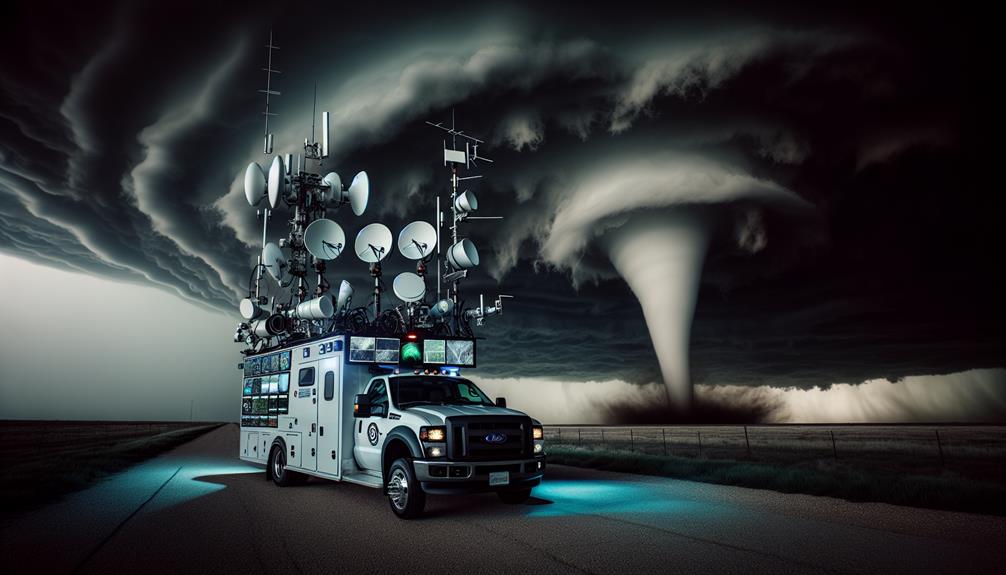
We track tornadoes using Doppler radar to measure storm velocity and direction, guaranteeing precision in predicting tornado paths. Mobile weather apps and GPS technology provide real-time alerts and accurate positioning even in remote areas, overlaying our locations with storm data for enhanced safety. Drones offer high-resolution footage, enhancing our understanding of tornado behavior and aiding damage assessment. Robust communication networks, including NOAA Weather Radio and smartphone apps, guarantee we stay connected and receive immediate updates. These combined tools allow us to pursue tornadoes safely and effectively. Learn more about the techniques we use to stay ahead of the storm.
Key Points
- Use Doppler radar technology to monitor storm velocity, direction, and anticipate tornado paths.
- Leverage mobile weather apps for real-time storm data, alerts, and detailed meteorological analysis.
- Employ GPS technology for precise tracking relative to storm paths and overlaying on radar images.
- Utilize drone surveillance to capture high-resolution footage for analysis and evaluate storm damage.
Radar Systems
Radar systems are necessary tools that allow us to detect, track, and analyze the development of tornadoes in real-time. By leveraging Doppler radar technology, we can measure the velocity and direction of storm systems, providing vital data for storm prediction and weather monitoring. This capability is particularly important in regions like Tornado Alley, where severe weather events pose significant risks.
In the heart of Tornado Alley, Doppler radar stations are strategically positioned to cover vast areas, ensuring thorough weather monitoring. These systems emit pulses of microwave energy, which bounce off precipitation particles within storm clouds. By analyzing the returned signals, we can determine the storm's structure, intensity, and potential for tornado formation.
The integration of Doppler radar data into our storm prediction models enhances accuracy, giving us the foresight needed to issue timely warnings. This real-time analysis isn't just about scientific curiosity; it's about providing the freedom to prepare and respond effectively to imminent threats.
Through precise interpretation of radar data, we can anticipate tornado paths and mitigate damage, safeguarding lives and property. Therefore, radar systems remain indispensable in our quest to understand and confront the dynamic forces of nature.
Mobile Weather Apps
Harnessing the power of mobile weather applications, we can access real-time storm data and alerts, ensuring we stay informed and prepared. These apps provide us with essential updates on severe weather conditions, allowing us to make timely decisions during storm chases. By examining radar imagery, storm tracks, and precipitation levels, we gain a thorough understanding of the situation.
Mobile weather apps often feature customizable emergency alerts, which notify us of impending tornadoes or other severe weather events. These alerts are vital for our safety, as they provide advance warnings that enable us to adjust our course or seek shelter. Additionally, many apps offer detailed meteorological data, including wind speeds, humidity levels, and atmospheric pressure, which help us analyze storm development with accuracy.
Integration with national weather services enhances the reliability of these apps, providing data from authoritative sources. We can also access user-generated reports, giving us ground-level insights into storm impacts.
GPS Technology
While mobile weather apps provide us with real-time data, GPS technology guarantees we can accurately track our position relative to the storm's path. Utilizing satellite tracking, we can pinpoint our exact location even in the most remote areas. This precision is essential for storm chasers who need to navigate quickly and safely. By integrating GPS with our weather apps, we can overlay our position on radar images, thereby ensuring we stay within best viewing distances without entering risky zones.
Moreover, GPS technology enhances our ability to receive timely emergency alerts. These alerts can warn us of sudden changes in the storm's trajectory, giving us critical seconds to adjust our course. The combination of satellite tracking and emergency alerts forms a robust system that supports both our safety and our mission to gather data.
In our vehicles, GPS devices provide turn-by-turn navigation, reducing the cognitive load so we can focus on observing weather patterns. By constantly updating our position, GPS ensures we've the freedom to chase storms without getting lost or missing critical developments. Ultimately, GPS technology empowers us to pursue our passion with greater accuracy and safety.
Drone Surveillance
Drone surveillance allows us to capture high-resolution, real-time footage of tornadoes from vantage points that are otherwise inaccessible. This capability is essential for analyzing weather patterns and predicting tornado behavior with greater precision. By deploying drones, we can observe the formation and movement of storm cells from above, gaining insights that ground-based observations simply can't provide.
The aerial footage collected by drones plays a pivotal role in evaluating storm damage and facilitating disaster response. After a tornado has passed, drones can quickly survey affected areas, providing detailed images that help emergency responders prioritize their efforts. This rapid evaluation reduces the time it takes to deliver aid and assess structural damage, thereby expediting recovery operations.
Moreover, the precision of drone surveillance aids in the development of more precise weather models. By integrating high-resolution data into predictive algorithms, we can enhance our understanding of tornado genesis and evolution. This, in turn, improves early warning systems, potentially saving lives.
Communication Networks
Effective communication networks are necessary for coordinating storm-chasing efforts and securing the safety of all involved personnel. We depend on a combination of emergency alerts and social media outreach to stay informed and connected in real-time.
Emergency alerts form the foundation of our communication strategy. Utilizing NOAA Weather Radio and smartphone apps with push notifications, we receive immediate updates on severe weather conditions. These alerts are vital for making swift decisions, such as repositioning to safer locations or deploying specialized equipment.
Social media outreach complements this by providing a platform for real-time information sharing. Platforms like Twitter and Facebook enable us to disseminate important updates and visual data quickly. By following meteorologists, weather agencies, and fellow storm chasers, we gain access to a wealth of crowd-sourced information that can refine our strategies.
To guarantee redundancy, our communication network integrates traditional radio systems and satellite phones. This multi-layered approach ensures that we remain connected even if one channel fails.
Frequently Asked Questions
What Safety Gear Should Storm Chasers Always Carry?
We should always carry emergency supplies, including first aid kits and non-perishable food. Reliable communication devices, like satellite phones and two-way radios, are essential for safety and coordination during storm chasing. Proper gear guarantees our freedom to explore.
How Do You Identify a Tornado Formation in the Field?
We don't need crystal balls, just sharp eyes. Identifying characteristics like rotating wall clouds and funnel shapes, paired with specific weather patterns, clue us in on tornado formation. Observing these signs guarantees we stay ahead of the storm.
What Are the Best Vehicle Modifications for Storm Chasing?
For storm chasing, we need roof racks for gear, emergency lights for visibility, reinforced windows for safety, and a GPS tracker for real-time location. These modifications guarantee we're prepared and protected while pursuing our passion.
Can You Describe the Psychological Challenges Storm Chasers Face?
Facing the eye of the storm demands emotional resilience; the mental toll is intense. We grapple with fear, yet the adrenaline rush drives us. Constantly analyzing perilous conditions, we balance thrill and caution, embracing the freedom it brings.
How Do Storm Chasers Contribute to Scientific Research?
We enhance scientific research impact through meticulous data collection and advanced chasing techniques. By analyzing the gathered data, we provide critical insights, improving predictive models and understanding of tornado behavior, ultimately empowering communities to mitigate risks.