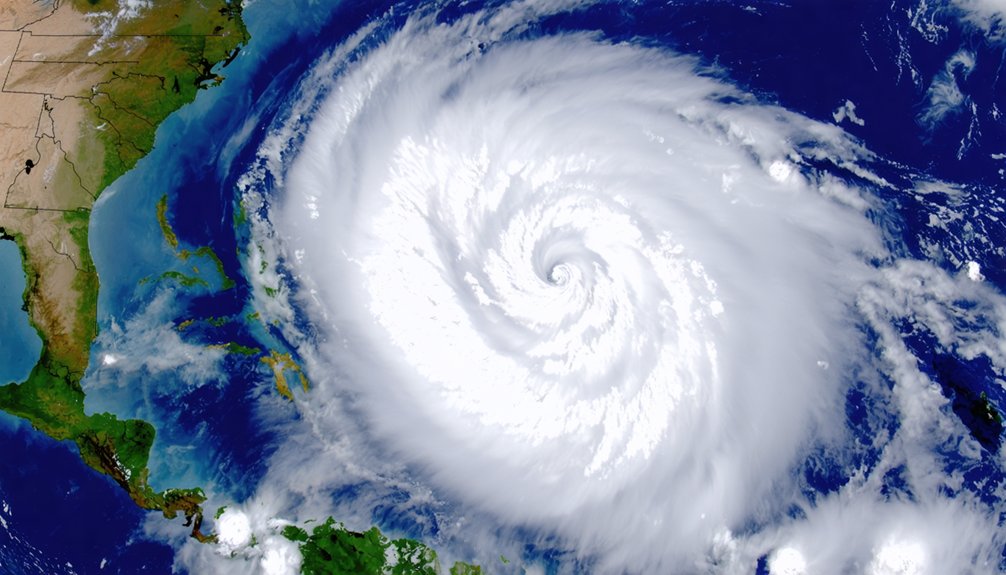
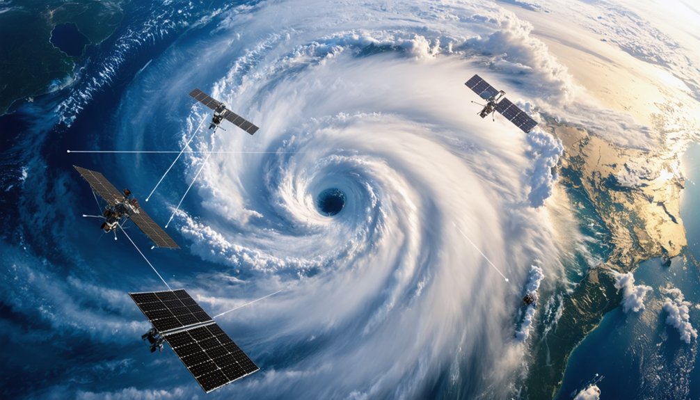
Satellites track your hurricane through a dual-orbit system: geostationary platforms stationed 22,000 miles above fixed ocean points deliver 30-second rapid scans with 0.6-mile resolution, while polar-orbiting JPSS satellites complete 14 daily passes at 520 miles altitude, measuring atmospheric profiles at 375-meter precision. You’ll receive 3-to-7 day advance predictions as microwave radiometers penetrating storm cores detect 183 GHz emissions, revealing precipitation structures and wind fields in 5-knot increments. AI models now process this data fusion—generating ensemble forecasts in under two minutes—transforming satellite measurements into actionable intelligence.
Key Takeaways
- Geostationary satellites provide continuous monitoring with 30-second rapid scans, tracking complete storm life cycles over Atlantic and Pacific Oceans.
- Polar-orbiting JPSS satellites complete 14 daily passes, measuring atmospheric temperature and moisture profiles to enable 3-to-7 day advance hurricane predictions.
- Microwave radiometers penetrate clouds to reveal 3D storm structures, precipitation patterns, and heat signatures from deep convection within hurricane cores.
- TROPICS CubeSats deliver observations every 21 minutes, capturing rapid intensification events like Milton’s transformation to Category 5 within 48 hours.
- AI models process satellite data through pattern recognition algorithms, generating thousands of probabilistic forecasts in minutes to enhance evacuation decision-making.
The Eye in the Sky: Geostationary Satellites for Continuous Storm Monitoring
Perched 22,236 miles above the equator, GOES East and GOES West satellites lock into geostationary orbit to maintain continuous surveillance of hurricane-prone ocean basins. You’ll find GOES East positioned over the Atlantic, while GOES West monitors the Eastern and Central Pacific. This fixed positioning delivers uninterrupted tropical ocean monitoring across the Western Hemisphere’s primary formation zones.
The Advanced Baseline Imager transforms storm imaging quality through 30-second rapid scans and spatial resolution reaching 0.6 miles—quadruple the clarity of previous systems. You’re no longer dependent on intermittent flyovers or limited reconnaissance range. These satellites track complete storm life cycles without gaps, measuring critical parameters including sea surface temperatures, vertical wind shear, and cloud top temperatures. Spare satellites maintain operational redundancy, ensuring you’ll retain independent access to real-time meteorological data.
Penetrating the Clouds: Microwave Instruments Reveal Hidden Hurricane Dynamics
Unlike visible-light sensors that bounce off cloud tops, microwave radiometers slice through storm layers to expose hidden precipitation structures and atmospheric dynamics. You’ll find these instruments detect natural emissions at frequencies like 183 GHz, enabling atmospheric profile generation of temperature and humidity despite dense cloud cover. Rain intensity manifests through increased emission magnitude, while shorter wavelengths track ice particles in upper hurricane regions.
Modern systems like COWVR and TEMPEST achieve 3D storm structure estimation at 1/100th the size of legacy sounders. NASA’s TROPICS mission demonstrates this capability, delivering hourly revisit rates and over 11 billion observations by 2025. You’re witnessing data refresh cycles that capture rapid intensification events previously missed during 10-hour observational gaps—critical intelligence for independent decision-making when facing evolving threats.
Polar-Orbiting Satellites: Capturing Critical Data From Above
JPSS satellites orbit 520 miles above Earth’s surface, completing 14 pole-to-pole passes daily while their ATMS and CrIS instruments measure atmospheric temperature and moisture profiles with spectral detail exceeding legacy POES capabilities.
You’ll find these sensors penetrate storm cores to map heat signatures from deep convection, enabling forecasters to reduce landfall prediction uncertainty through precise analysis of hurricane internal structure.
VIIRS captures high-resolution visible and infrared observations at 375-meter spatial resolution, revealing wind patterns and convective towers that signal intensity changes hours before they become apparent at the surface.
JPSS Weather Prediction Contributions
Managed jointly by NASA and NOAA, the Joint Polar Satellite System represents a critical advancement over its predecessor, the Polar Operational Environmental Satellites (POES), delivering enhanced real-time data capabilities essential for hurricane tracking and prediction.
You’ll access global weather coverage twice daily through 14 orbital passes, with data processing achieving sub-30-minute turnaround from collection to delivery at weather centers. The Advanced Technology Microwave Sounder penetrates cloud cover to provide all-weather temperature and humidity profiles, enabling 3-to-7 day advance predictions of hurricane development.
Real-time data distribution supports operational products including the Hurricane Intensity Structure Algorithm and AI-driven precise wind field estimation. Without JPSS measurements, your track forecasting accuracy degrades markedly, limiting preparedness windows for severe weather events.
Hurricane Internal Structure Scanning
While geostationary satellites maintain fixed positions above Earth’s equator, polar-orbiting platforms traverse pole-to-pole paths at 520-mile altitudes, completing 14 orbital passes daily to capture hurricane internal structure with unprecedented precision. These satellites deploy advanced sensors that penetrate storm systems without surface obstruction, revealing hurricane internal structure evolution critical for forecasting.
Key scanning capabilities include:
- Microwave sounders detect heat signatures from deep convection within storm cores, exposing eyewall formation dynamics
- Infrared sensors measure cloud temperatures and central pressure variations that indicate intensification rates
- Atmospheric profilers analyze high altitude wind patterns and wind shear affecting trajectory
You’ll receive data showing how systems like Tropical Storm Milton evolved into Category 5 hurricanes within 48 hours, enabling meteorologists to narrow uncertainty cones and predict landfall parameters with measurable accuracy.
TROPICS CubeSats: Revolutionary Rapid-Fire Hurricane Observation
Six shoebox-sized satellites now orbit Earth in three separate planes, collectively forming NASA’s TROPICS (Time-Resolved Observations of Precipitation structure and storm Intensity with a Constellation of Smallsats) mission—a constellation that’s fundamentally transformed hurricane monitoring by delivering observations every 21 minutes.
Each 5.34 kg CubeSat carries microwave radiometers 100 times smaller than conventional sounders, yet they measure temperature profiles via seven 118.75 GHz channels, humidity through three 183 GHz channels, and precipitation-sized ice particles at 205-206 GHz.
You’re witnessing operational decision making support previously impossible—TROPICS captured Milton’s intensification from tropical storm to Category 5 within 48 hours, providing real time coastal flooding visualization through eyewall structure analysis. The Joint Typhoon Warning Center now integrates this data operationally, eliminating hours-long gaps that traditional systems couldn’t overcome.
Essential Measurements That Enable Accurate Hurricane Forecasting
Accurate hurricane forecasting requires satellites to collect precise ocean and atmospheric measurements that quantify storm intensity and development potential.
Sea surface temperature readings identify warm waters above 26.5°C that fuel tropical cyclone formation, while atmospheric pressure data from dropsondes reveal the barometric gradient between the eye and surrounding environment.
Storm structure indicators—including eyewall diameter, wind field extent, and vertical temperature profiles—enable forecasters to assess current strength and predict rapid intensification events that pose elevated coastal threats.
Ocean and Atmospheric Data
Critical data sources include:
- Argo floats — Over 4,000 autonomous units profile temperature and salinity across 2,000 meters, transmitting measurements every 10 days during peak season
- Underwater gliders — 83 deployments in 2023 provided continuous sampling across Atlantic, Caribbean, and Gulf regions throughout entire hurricane seasons
- ALAMO units — Aircraft-deployed sensors deliver real-time ocean profiles during active storm periods
This integrated approach enables forecasters to track rapid intensity changes with unprecedented accuracy.
Storm Structure Indicators
While ocean conditions provide the fuel for hurricane development, satellites must simultaneously measure multiple storm characteristics to generate reliable forecasts. You’ll find radiometers pierce cloud canopies to reveal internal structure—quantifying liquid water content and atmospheric humidity levels that determine intensification potential.
Maximum sustained wind speeds measured over one-minute intervals at 10-meter altitude tell only part of the story; quadrant-based analysis evaluates wind field size and distribution across storm sections. Precipitation distribution patterns mapped by NASA’s Global Precipitation Measurement mission enable flood forecasting separate from wind damage assessments. Lidar instruments characterize aerosols, moisture, and winds at multiple altitudes.
The National Hurricane Center assigns intensities in 5-knot increments, acknowledging measurement uncertainty. These combined metrics—wind duration, rainfall rates, pressure gradients—deliver the resolution you need for informed decision-making before landfall.
From Ocean Temperatures to Wind Shear: Key Parameters Satellites Monitor
To forecast hurricane behavior with precision, satellites continuously monitor five critical atmospheric and oceanic parameters that govern storm development and trajectory.
1. Sea Surface Temperature Modeling****
GOES and JPSS satellites measure ocean temperatures through infrared imagery, detecting thermal thresholds above 26.5°C that fuel hurricane intensification tracking. You’ll receive forecasts days in advance as polar-orbiting satellites provide precise measurements for formation prediction.
2. Wind Shear Assessment****
Satellites monitor upper-level wind patterns at multiple atmospheric levels, revealing vertical wind shear that either inhibits or enables tropical cyclone development. This data autonomously informs your storm direction and strength projections.
3. Atmospheric Moisture Distribution****
JPSS instruments scan moisture across multiple wavelengths, while infrared radiation data reveals humidity profiles essential for tracking storm evolution and predicting paths without ground-based limitations.
Artificial Intelligence and Satellite Data: The Future of Hurricane Prediction
Hurricane forecasting is undergoing a transformation as artificial intelligence converges with decades of satellite observations to deliver unprecedented prediction capabilities. You’re witnessing AI models trained on 40 years of global weather data, utilizing JPSS satellites that supply 85% of prediction inputs.
These systems execute integrative data fusion, processing satellite imagery, pressure gradients, and wind patterns through pattern recognition algorithms. Google DeepMind’s model outperformed conventional systems during Hurricane Erin’s Category 5 development, while correctly predicting Beryl’s Texas landfall when physics-based models favored Mexico.
You’ll benefit from iterative model improvements generating ensemble forecasts in 1-2 minutes versus hours on supercomputers. The NHC’s 2025 partnership with AI developers enables thousands of probabilistic outcomes, enhancing your evacuation decision-making with superior track accuracy and rapidly advancing intensity predictions.
Frequently Asked Questions
How Do Satellites Transmit Hurricane Data Back to Forecasting Centers on Earth?
Satellites transmit hurricane data to you through real-time downlinks at specific data transmission frequency bands. You’ll receive information from satellite sensor capabilities including microwave, infrared, and all-sky radiance measurements, processed through 5G networks for unrestricted forecasting center access.
What Happens When a Satellite Fails During an Active Hurricane Season?
Backup satellite systems activate immediately, maintaining continuous coverage. You’ll see forecasters shift to alternate data sources like aircraft reconnaissance and ground-based radar, though data gaps of 6-10 hours may delay intensification warnings and compromise evacuation timing precision.
How Much Does It Cost to Launch and Operate Hurricane Monitoring Satellites?
Satellite launch costs you’ll face range from $50-400 million per mission, while satellite operational budgets span decades—GOES-R’s $10.8 billion lifecycle covers four satellites through 2036, versus CYGNSS’s efficient $160 million eight-microsatellite constellation investment.
Can Satellites Detect Hurricanes Forming Over Land or Only Over Oceans?
Satellite detection of hurricane formation occurs exclusively over oceans where tropical cyclones develop from warm water evaporation. You’ll find inland hurricane monitoring capabilities track existing storms after landfall, measuring precipitation and flood inundation rather than detecting formation itself.
How Far in Advance Can Satellites Help Predict a Hurricane’s Landfall Location?
Satellite technology advancements enable you to receive reliable hurricane landfall predictions 3-5 days ahead. Early warning systems integrate real-time satellite data with atmospheric models, though uncertainty decreases as the storm approaches, giving you critical time to evacuate independently.