When intercepting severe thunderstorms, we prioritize understanding storm dynamics through high-definition radar data to analyze mesocyclones and atmospheric instability. We utilize advanced equipment, including radar systems, GPS devices, and safety gear like insulated boots and helmets. Adhering to strict safety protocols, such as maintaining a 10-kilometer distance from the storm core and pre-planning escape routes, is essential. Real-time data from radar, satellites, and surface observations is vital for precise navigation and forecasting. Effective communication and strong decision matrices guarantee team coordination and operational efficiency. For further insights on ensuring both accuracy and safety, there's more to explore.
Key Points
- Utilize high-resolution radar and GPS for real-time storm tracking and safe navigation.
- Equip with waterproof clothing, helmets, and insulated boots for protection against severe weather conditions.
- Maintain a minimum distance of 10 kilometers from the storm core to ensure lightning safety.
- Establish clear communication protocols and use reliable devices like satellite phones and two-way radios.
Understanding Severe Thunderstorms
Severe thunderstorms are characterized by high winds, large hail, and the potential to spawn tornadoes, making them an important focus for meteorological research. To effectively investigate these storms, we must first explore storm dynamics and forecasting techniques.
Storm dynamics involve understanding the lifecycle and structure of thunderstorms. We analyze parameters such as wind shear, updraft strength, and atmospheric instability to determine a storm's potential severity. High-resolution radar data allows us to visualize the internal mechanisms, including mesocyclones and supercells, which are essential for predicting tornado formation. By studying these elements, we can better anticipate the storm's behavior and trajectory.
Forecasting techniques are crucial in providing us the freedom to plan our interception strategies accurately. Numerical weather prediction models, such as the NAM and GFS, use complex algorithms to simulate atmospheric conditions. Ensemble forecasting further enhances our accuracy by running multiple simulations to account for uncertainties. Real-time data assimilation from satellite imagery, weather balloons, and ground-based observations feed into these models, refining our predictions. Additionally, nowcasting tools enable us to make short-term forecasts, vital for identifying rapidly evolving storm features.
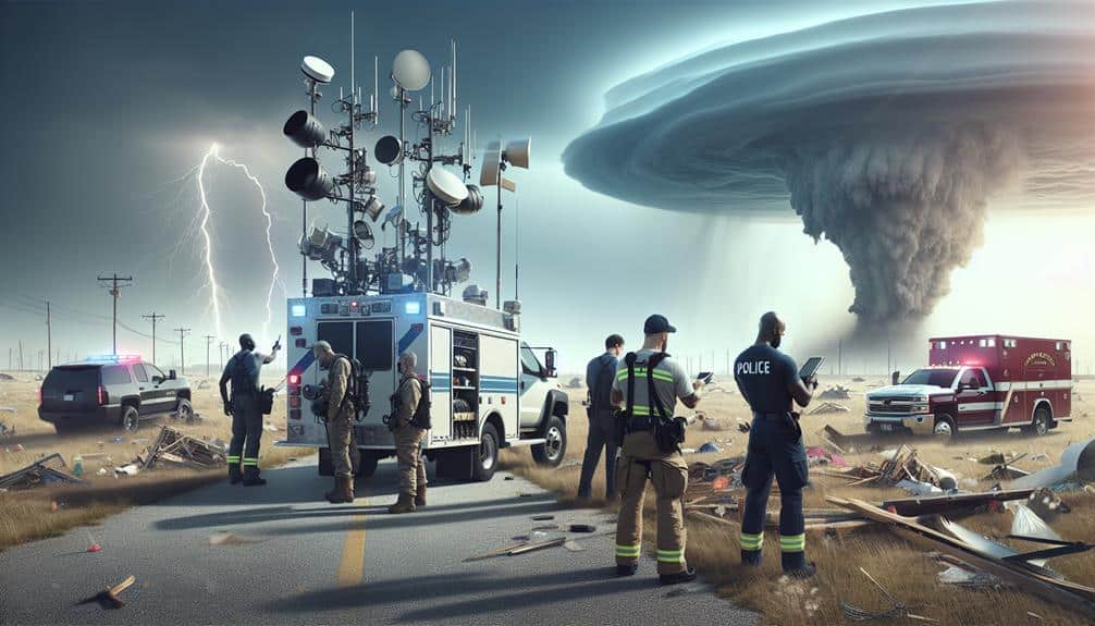
Equipment and Gear Essentials
Equipping ourselves with the right tools and gear is essential for successfully intercepting severe thunderstorms. We need precise instruments and robust gear to guarantee accurate data collection and personal safety. Necessary technology tools include advanced radar systems, GPS devices, and high-resolution cameras. These enable us to monitor storm developments, navigate accurately, and document phenomena in real-time.
Protective gear is equally vital. Without it, we risk exposure to extreme conditions, which can impede our mission. High-quality protective gear includes:
- Waterproof clothing: Keeps us dry and prevents hypothermia in heavy rain.
- Helmet with face shield: Safeguards us from debris and flying objects.
Moreover, reliable communication devices are essential for coordinating with our team and emergency services. Satellite phones and two-way radios provide connectivity even in remote areas, guaranteeing continuous contact.
Incorporating these technology tools and protective gear into our setup allows us to intercept severe thunderstorms effectively and safely. By prioritizing data accuracy and personal safety, we can navigate the dynamic and unpredictable nature of severe weather, maximizing our freedom to explore and study these powerful natural events.
Safety Precautions
Guaranteeing our safety during thunderstorm interception demands careful planning and adherence to established protocols. First, lightning safety is paramount. We must maintain a minimum distance of 10 kilometers from the storm's core to reduce the risk of lightning strikes. Using vehicles equipped with lightning rods and grounding systems can further boost our protection. Additionally, we should steer clear of open fields, isolated trees, and metallic objects during thunderstorms, as these are prime targets for lightning.
Emergency shelters play a pivotal role in our safety strategy. Identifying nearby structures capable of withstanding high winds and providing adequate cover is essential. These shelters can include reinforced buildings or underground storm cellars. We should pre-plan our interception routes to make certain that we can reach these shelters within minutes if conditions deteriorate rapidly.
When positioning ourselves to monitor the storm, we must verify that our escape routes are clear and unobstructed. Constant communication with team members via radio and GPS tracking ensures that everyone remains accounted for and can respond quickly to any emergency.
Analyzing Weather Data
Analyzing weather data meticulously involves interpreting radar readings, satellite imagery, and surface observations to predict storm behavior accurately. We rely heavily on data visualization to make sense of the intricate information collected.
Radar analysis is pivotal, providing us with real-time data on precipitation intensity, wind patterns, and potential tornado formations. By integrating these data points, we improve our forecasting techniques, enabling us to anticipate severe weather with greater precision.
Utilizing satellite imagery, we gain a broader view of storm systems, identifying cloud formations and temperature variations that impact storm development. This macroscopic perspective complements the detailed data from radar analysis, offering a holistic approach to storm prediction.
Surface observations, including temperature, humidity, and pressure readings, provide ground truth to the atmospheric conditions, ensuring our predictions are rooted in real-world data.
Key components of our data analysis include:
- Radar Analysis: Detects precipitation, wind patterns, and storm cells.
- Satellite Imagery: Offers a detailed view of storm systems and cloud formations.
Communication Protocols

We must prioritize strong communication protocols to effectively intercept severe thunderstorms.
Utilizing Emergency Alert Systems enhances public safety by disseminating real-time warnings.
Implementing advanced team coordination strategies guarantees seamless information flow and rapid response.
Emergency Alert Systems
Effective communication protocols are essential for emergency alert systems to rapidly disseminate severe thunderstorm warnings to the public and relevant authorities. We must make sure that our alert notifications aren't only timely but also accurate to enable swift action. Using advanced technology and data analytics, we can enhance the precision of our warnings, guaranteeing communities can respond effectively.
Key components of our emergency alert systems include:
- Automated Alert Notifications: Utilizing automated systems guarantees that warnings are broadcasted immediately, reducing response times.
- Multi-Channel Dissemination: Leveraging various platforms—such as mobile apps, radio, and social media—ensures the widest possible reach.
We rely on data from radar, satellites, and weather stations to generate real-time alerts. This data-driven approach helps us predict the path and intensity of severe thunderstorms with higher accuracy. By integrating these protocols, we empower individuals to make informed decisions, enhancing their freedom to stay safe.
Our goal is to maintain a robust communication network that minimizes delays and maximizes the reliability of information. These measures are essential for safeguarding lives and property during severe weather events.
Team Coordination Strategies
To guarantee smooth team coordination during severe thunderstorms, establishing clear and efficient communication protocols is vital. Our leadership dynamics must emphasize situational awareness and rapid information dissemination. We rely on communication techniques such as encrypted radio transmissions and real-time data sharing through secure digital platforms. These methods make certain that every team member receives critical updates without delay.
In the domain of decision-making processes, predefined roles and responsibilities are necessary. Each team member should know their specific tasks, whether it's data analysis, field reporting, or logistical support. This clarity reduces confusion and enhances our operational efficiency. We utilize decision matrices to prioritize actions, ensuring that the most urgent tasks receive immediate attention.
Teamwork dynamics play an important role in our success. Regular briefings and debriefings allow us to synchronize efforts and address any issues promptly. We also employ redundancy systems, such as backup communication channels, to maintain contact even if primary systems fail.
Traversing severe thunderstorms demands a precise understanding of meteorological patterns and real-time data analysis to optimize safety and efficiency. Our navigational strategies hinge on leveraging advanced intercepting techniques and maintaining an aerial perspective for enhanced situational awareness. This approach facilitates accurate tracking and positioning relative to the storm's core, maximizing our ability to capture critical data while minimizing risk.
Key elements of our navigational strategy include:
- High-resolution radar data: We rely on Doppler radar to provide real-time updates on storm structure, velocity, and potential severe weather signatures.
- GPS tracking systems: These systems guarantee precise location data, enabling us to navigate safely around the storm.
Storm chasing offers an adrenaline rush, but it necessitates a disciplined approach to navigation. By integrating these data-driven strategies, we can observe storm dynamics up close while upholding a margin of safety. The goal is to be in the right place at the right time, capturing valuable meteorological data without compromising our safety. This strategic balance of risk and reward is essential for successful storm interception.
Post-Intercept Procedures
After safely navigating the storm, we immediately begin post-intercept procedures to ensure data integrity and equipment functionality. First, we secure all collected data from our instruments, guaranteeing redundancy by backing up on multiple storage devices. This step is crucial; data loss would invalidate the entire mission.
Next, we conduct a thorough equipment check to identify any damage or calibration issues that could compromise future data collection.
The debriefing process follows, where we meticulously review the events of the intercept. Each team member provides a detailed account of their observations and actions. This collaborative effort helps identify any procedural lapses or areas for improvement. We compile this information to create a comprehensive report, which serves as a valuable resource for refining our techniques.
For the post-storm evaluation, we analyze the collected data, comparing it against meteorological models and forecasts. This evaluation helps validate our predictive models and improves our understanding of storm dynamics. We also assess the performance of our equipment and software, making necessary adjustments to enhance accuracy and reliability.
Frequently Asked Questions
How Do Severe Thunderstorms Impact Local Wildlife and Ecosystems?
When severe thunderstorms occur, wildlife habitats can be destroyed, but many species show remarkable adaptation. Ecosystem resilience is tested, yet recovery often follows as biodiversity rebounds, showcasing nature's incredible ability to heal and thrive.
Can Thunderstorms Affect Air Travel and Flight Schedules?
Yes, thunderstorms can severely impact air travel and flight schedules. Due to lightning hazards, we've seen numerous airport closures, causing significant delays and rerouting. Frequent disruptions highlight the need for advanced meteorological data to guarantee passenger safety.
What Are the Signs of a Thunderstorm Forming While Outdoors?
We should prioritize thunderstorm awareness by observing darkening skies, increased wind speeds, and sudden temperature drops. Weather forecasting tools are essential for safety tips during outdoor activities, ensuring we stay informed and prepared for potential severe weather.
How Do Severe Thunderstorms Influence Emergency Services and Response Times?
Severe thunderstorms greatly impact emergency services by requiring improved emergency preparedness and precise response coordination. We often face delayed response times due to hazardous conditions, necessitating careful planning and real-time data to maximize service delivery.
Are There Any Historical Records of Unusual Severe Thunderstorms?
We've analyzed historical records and identified several severe thunderstorms classified as historical anomalies due to their unusual weather patterns. These events highlight the need for precise data to understand and anticipate future meteorological phenomena.