We use a multi-pronged approach to intercept severe thunderstorms, combining advanced radar systems and satellite imagery for precise tracking. By analyzing meteorological data and real-time monitoring, we capture crucial atmospheric variables such as wind speed and temperature. Utilizing GPS-enabled communication devices and mobile weather stations, we ensure smooth coordination. Safety protocols and specialized gear enhance our field operations. We also deploy drones and balloons for thorough data collection within storm systems. Post-intercept, we review and validate the data with meteorological institutes. Stay with us to explore the breadth of our all-encompassing strategy and its impact on storm research.
Key Points
- Deploy advanced radar systems for enhanced detection and tracking of storm features.
- Utilize real-time data collection tools for immediate analysis of storm dynamics.
- Coordinate intercepts using GPS tracking and secure real-time communication channels.
- Implement drone and balloon deployment for in-depth atmospheric data collection.
Understanding Storm Patterns
To understand storm patterns, we analyze meteorological data to identify the conditions that lead to severe thunderstorms. By examining atmospheric pressure, humidity levels, temperature gradients, and wind shear, we can pinpoint the factors that contribute to storm development.
Our primary focus is on storm tracking and interpreting weather patterns to predict the formation and trajectory of severe weather events.
We utilize high-resolution satellite imagery and surface observation networks to gather data on current atmospheric conditions. These tools enable us to observe changes in weather patterns, such as the formation of cumulonimbus clouds and the development of low-pressure systems, which are often precursors to severe thunderstorms.
By correlating these observations with historical data, we can identify trends and anomalies that signal the potential for severe weather.
Storm tracking involves continuously monitoring these evolving conditions. We employ numerical weather prediction models to simulate future weather scenarios, giving us a clearer picture of storm movement and intensity. These models, combined with real-time data, allow us to refine our forecasts and issue timely warnings.
Using Advanced Radar Systems
Leveraging advanced radar systems, we can obtain high-resolution data essential for analyzing and predicting severe thunderstorms. These radar technology advancements greatly enhance data accuracy, which is essential when we're out in the field intercepting storms.
The benefits to our research are manifold, and we've identified four key advantages to using these systems:
- Enhanced Spatial Resolution: Modern radar systems provide finer spatial resolution, allowing us to detect smaller and more subtle storm features. This increased detail helps us understand the storm's structure and evolution better.
- Improved Temporal Resolution: With faster scan rates, we can capture rapid changes within the storm. This is important for tracking the development of severe weather phenomena like tornadoes or microbursts, giving us a real-time edge during storm interception.
- Dual-Polarization Capabilities: Advanced radars now come equipped with dual-polarization technology, which helps differentiate between types of precipitation (rain, hail, snow). This capability greatly improves our data accuracy, leading to more precise storm analysis.
- Extended Range Detection: Modern radar systems can detect weather patterns at greater distances. This extended range allows us to plan our interception routes more effectively, ensuring we can gather data from the most intense parts of the storm.
Utilizing Satellite Imagery
Satellite imagery offers us a detailed view of severe thunderstorms, enabling real-time monitoring and in-depth analysis from a broader perspective. By leveraging remote sensing technologies, we can observe the development and progression of storm systems with unprecedented accuracy. High-resolution images from geostationary and polar-orbiting satellites allow us to track storm formation, intensity fluctuations, and movement across vast areas.
Using satellite data, we can integrate multiple spectral bands to analyze storm structure, cloud tops, and precipitation rates. This multifaceted approach enhances our storm tracking capabilities, providing critical data points for predicting storm behavior and potential impact zones.
For instance, the Visible Infrared Imaging Radiometer Suite (VIIRS) on the Suomi NPP satellite offers day-night band imagery to identify lightning and other severe weather indicators even in low-light conditions.
Real-time access to these satellite images allows us to make informed decisions on storm interception routes and safety protocols. Additionally, remote sensing facilitates the early detection of supercell formations, giving us invaluable lead time.
This data-driven approach empowers us to navigate the complexities of severe weather research with greater precision and effectiveness, ultimately contributing to our understanding and forecasting of these powerful natural phenomena.
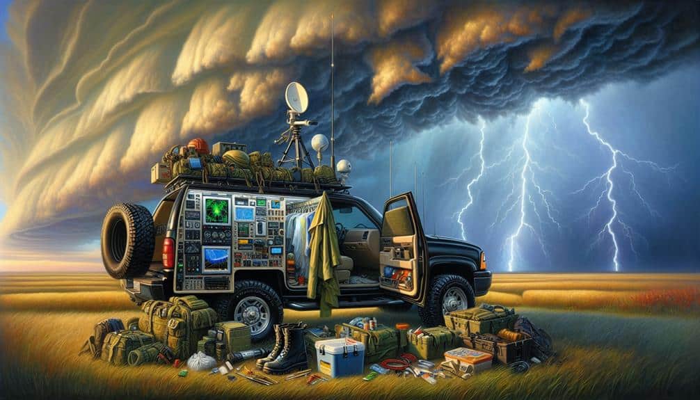
Mobile Weather Stations
Let's examine the role of mobile weather stations in our research efforts.
These units allow us to set up portable instrumentation for real-time data collection, providing critical meteorological readings directly from the field.
However, we must also address the deployment challenges and identify effective solutions to guarantee accurate and reliable data.
Portable Instrumentation Setup
Our mobile weather stations, equipped with high-precision sensors and real-time data transmission capabilities, provide important insights into the development and behavior of severe thunderstorms. These stations are essential for field observations and weather tracking, allowing us to capture valuable data in dynamic and rapidly changing environments.
When we set up our portable instrumentation, we focus on the following key components to ensure thorough data collection during our storm chasing missions:
- Anemometers: These devices measure wind speed and direction, providing us with vital information about storm intensity and movement patterns.
- Barometers: By monitoring atmospheric pressure changes, we can predict the likelihood of severe weather events and track storm development with greater accuracy.
- Thermometers and Hygrometers: These sensors measure temperature and humidity levels, helping us understand the atmospheric conditions that contribute to storm formation.
- GPS Units: Accurate positioning is important for correlating our data with specific geographic locations, enhancing the precision of our field observations.
Our mobile weather stations enable real-time weather tracking, giving us the freedom to adapt our data collection strategies on-the-fly. By leveraging these advanced portable setups, we can gather valuable information to better understand and predict severe thunderstorms, ultimately contributing to improved weather forecasting and public safety.
Real-time Data Collection
Real-time data collection from mobile weather stations allows us to monitor and analyze storm dynamics with unparalleled immediacy and accuracy. By leveraging advanced storm tracking technologies, we can capture critical atmospheric variables such as wind speed, temperature, humidity, and barometric pressure.
These mobile weather stations are equipped with remote sensing instruments that provide continuous data transmission to our central monitoring systems.
Data visualization tools enable us to process and interpret vast amounts of real-time information quickly. This capability is essential for making informed decisions during severe weather events.
High-resolution data streams from multiple mobile units allow us to construct detailed models of storm behavior, enhancing our predictive capabilities and improving public safety.
We utilize cutting-edge GPS technology to guarantee precise geolocation of each mobile station, ensuring that our storm tracking efforts are both accurate and effective.
The integration of remote sensing data with real-time telemetry provides a robust framework for understanding storm evolution and intensity.
Deployment Challenges and Solutions
Deploying mobile weather stations in the field presents numerous logistical and technical challenges that require innovative solutions. First, we must address deployment logistics. Moving sophisticated equipment across varied terrains demands meticulous planning.
Second, ensuring the continual operation of our instruments under harsh weather conditions involves rigorous equipment maintenance.
Here are four key strategies we've developed:
- Route Planning: We use advanced GPS and weather forecasting tools to chart the safest and most efficient routes. This minimizes travel time and maximizes data collection opportunities.
- Equipment Redundancy: To mitigate risks of equipment failure, we employ redundant systems. Each mobile station carries backup sensors and communication devices, ensuring data integrity even if primary systems fail.
- Real-Time Monitoring: Our stations are equipped with real-time diagnostic tools. These tools alert us to potential malfunctions, allowing us to perform on-the-spot repairs or adjustments.
- Modular Design: We design our weather stations to be modular. This allows for quick assembly and disassembly, facilitating rapid deployment and retrieval during unpredictable storm conditions.
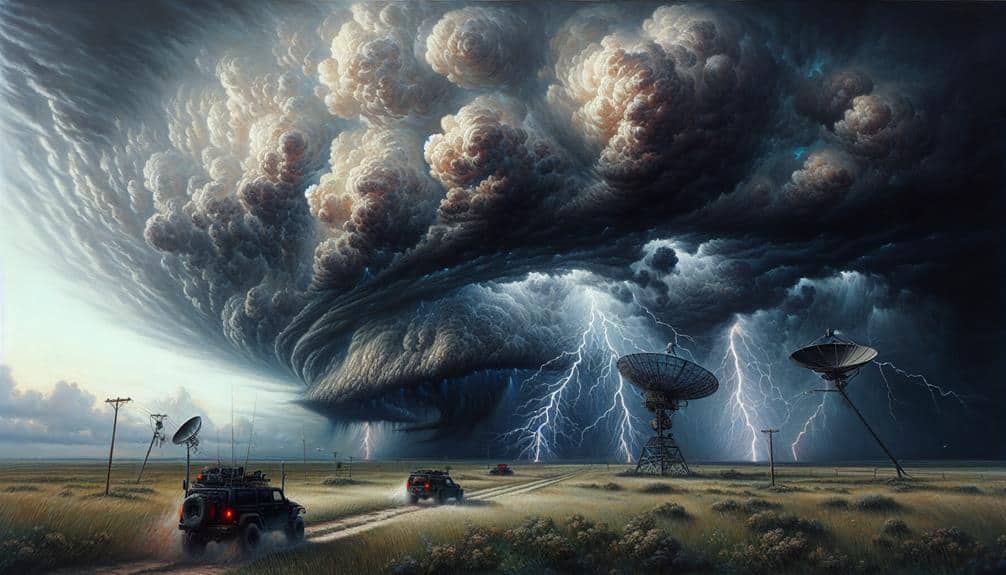
GPS and Mapping Tools
Utilizing advanced GPS and mapping tools, meteorologists can precisely track and analyze the movement of severe thunderstorms, enhancing the accuracy of data collection. Through GPS tracking, we can pinpoint our exact location relative to storm cells, allowing us to navigate safely and efficiently. This precision guarantees that our instruments collect high-quality data, which is vital for understanding storm dynamics.
Mapping software further complements GPS tracking by providing real-time visualizations of storm paths, intensity, and potential impact areas. These tools integrate various data layers, including radar imagery, satellite observations, and historical weather patterns, to offer a detailed situational awareness. By overlaying GPS coordinates onto these dynamic maps, we can anticipate storm developments and make informed decisions on intercept routes.
The combination of GPS tracking and sophisticated mapping software empowers us to deploy our resources strategically. For instance, we can identify best locations for placing mobile weather stations or launching weather balloons. Furthermore, these tools facilitate the coordination of multiple research teams, ensuring that data collection efforts are synchronized and thorough.
Ultimately, the use of advanced GPS and mapping tools not only enhances our efficiency but also amplifies the strength of the collected data, contributing significantly to our understanding of severe thunderstorms.
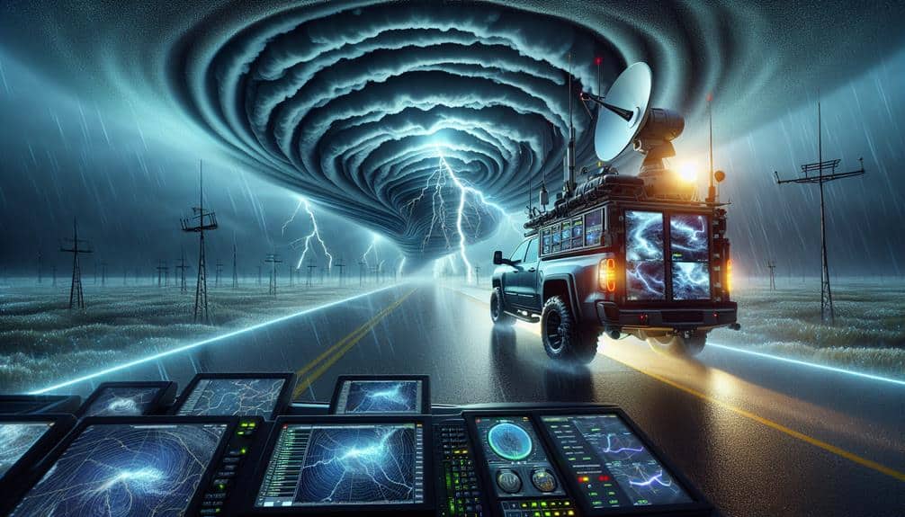
Real-Time Data Analysis
We utilize live weather monitoring tools to gather real-time data on storm behavior and dynamics.
By employing rapid data interpretation techniques, we can quickly analyze and respond to evolving storm conditions.
This approach enhances our ability to predict severe weather events with greater accuracy and timeliness.
Live Weather Monitoring Tools
In the field of severe thunderstorm research, real-time data analysis through cutting-edge live weather monitoring tools is essential for accurate and timely observations. By leveraging these tools, we can enhance our weather tracking capabilities and optimize storm chasing operations.
Here are four vital tools that form the backbone of our real-time data analysis framework:
- Doppler Radar Systems: These systems provide high-resolution data on precipitation, wind speed, and storm structure, allowing us to track the development and movement of severe thunderstorms with precision.
- Satellite Imagery: Real-time satellite feeds deliver important information on storm formation and intensity, covering vast geographical areas that ground-based systems might miss.
- Mesonets: These networks of automated weather stations offer localized, high-frequency data on temperature, humidity, and pressure, which are essential for understanding microclimates and predicting storm behavior.
- Mobile Weather Units: Equipped with sensors and communication systems, these units allow us to gather and transmit data directly from the storm's path, providing unparalleled insights during storm chasing missions.
Utilizing these advanced tools, we can make informed decisions, minimize risks, and maximize the effectiveness of our severe thunderstorm research efforts. Real-time data is the cornerstone of our strategy, delivering the freedom to act swiftly and accurately in dynamic weather conditions.
Rapid Data Interpretation Techniques
Building on our use of advanced live weather monitoring tools, rapid data interpretation techniques enable us to convert incoming real-time data into actionable insights swiftly and efficiently. By leveraging storm tracking and data visualization, we can identify severe weather patterns with unparalleled accuracy. Real-time remote sensing technologies, such as Doppler radar and satellite imagery, provide us with essential atmospheric data.
These data streams are then integrated to form a detailed picture of the storm dynamics. Our approach employs sophisticated algorithms that prioritize data integration, ensuring that disparate sources are harmonized seamlessly. This integration allows us to filter out noise and focus on critical variables like wind speed, precipitation intensity, and storm cell movement.
By visualizing this data, we can anticipate the storm's trajectory and potential impact zones. Moreover, rapid data interpretation techniques facilitate immediate decision-making. We can deploy research teams to strategic locations, enhancing our ability to collect high-quality data and improve predictive models.
This agility not only advances our understanding of severe thunderstorms but also contributes to more effective storm preparedness and response strategies. Ultimately, our techniques empower us to act swiftly, ensuring that we remain at the forefront of storm research and safety.
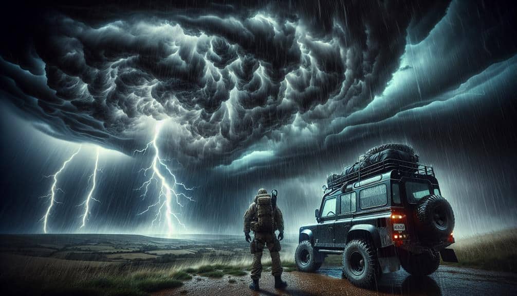
Safety Protocols and Gear
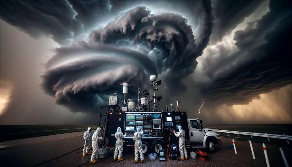
To ensure our safety during severe thunderstorm research, we must adhere to strict protocols and use specialized gear designed to withstand extreme weather conditions. Safety precautions and necessary gear are vital in mitigating risks associated with such volatile environments.
We follow a set of established safety protocols which include the following measures:
- Necessary Gear: We equip ourselves with reinforced helmets, waterproof and windproof clothing, and high-traction boots. Additionally, we use advanced weather monitoring devices to track storm developments in real-time.
- Emergency Protocols: In the event of a sudden escalation in storm severity, we've pre-defined evacuation routes and designated storm shelters. These shelters are strategically located to provide rapid access and are built to withstand high wind speeds and flying debris.
- Communication Devices: Each team member carries a GPS-enabled communication device, ensuring constant contact with command centers and other team members. This is vital for coordinating movements and executing emergency protocols efficiently.
- First Aid Kits: Thorough first aid kits are mandatory in every vehicle. These kits include not only basic medical supplies but also equipment for treating injuries specific to storm-related incidents, such as cuts from debris or hypothermia.
Communication and Coordination
Effective communication and coordination are paramount in ensuring our team operates seamlessly during severe thunderstorm research missions. We utilize real-time data exchanges via secure communication channels to maintain best team communication. GPS tracking and instant messaging systems help us coordinate storm intercepts, ensuring that each team member is aware of their precise location and role.
Storm coordination involves synchronizing multiple units, often spread across vast geographical areas, to collect high-quality data. We rely on advanced weather updates, sourced from radar, satellite, and ground-based observations, to make informed decisions. This enables us to adjust our positions dynamically in response to the evolving storm structure.
In scenarios requiring emergency response, our communication protocols become even more critical. We've established predefined emergency codes and signals that allow us to quickly convey the severity of situations and necessary actions. This minimizes confusion and maximizes response efficiency.
Our operations center continuously monitors all communications, ensuring that any issues are promptly addressed.
Deploying Drones and Balloons

Deploying drones and balloons enables us to gather pivotal atmospheric data from within the storm's structure, enhancing our understanding of severe thunderstorm dynamics. Utilizing drone surveillance and balloon research in storm interception operations allows us to collect data that's otherwise inaccessible. These technologies provide a thorough view of the storm's internal processes and immediate environment.
To achieve effective data collection, we adhere to the following strategies:
- Drone Surveillance: We deploy drones equipped with sensors to measure wind speed, temperature, humidity, and pressure. These drones can navigate through hazardous conditions, providing real-time data from the storm's core.
- Balloon Research: High-altitude balloons, carrying sophisticated instrumentation packages, ascend through the storm, capturing vertical profiles of atmospheric parameters. This data is essential for understanding the vertical structure and evolution of severe thunderstorms.
- Storm Interception Timing: Precise timing in launching drones and balloons is essential. We utilize advanced weather modeling to predict storm paths, ensuring our equipment is deployed at optimal moments for maximum data yield.
- Data Integration: Combining data from drones and balloons with ground-based radar and satellite observations enhances the resolution and accuracy of our storm models, leading to better predictions and mitigation strategies.
Post-Intercept Data Review
After successfully intercepting a severe thunderstorm, we meticulously examine the collected data to extract meaningful insights into storm behavior and dynamics. Post-intercept debriefings are essential for initial data validation, ensuring that sensors and instruments performed efficiently during the interception. Each team member reviews the captured data streams, focusing on parameters like wind speed, humidity, and pressure variations.
Our next step involves storm impact assessment, where we quantify the extent of the storm's influence on the surrounding environment. By cross-referencing our data with satellite imagery and ground-based observations, we can validate our findings and identify any anomalies. This thorough data validation process helps us refine our models and improve predictive accuracy.
Research collaboration plays a significant role in this phase. We share data with meteorological institutes and academic partners to facilitate a thorough analysis. Collaborative efforts amplify our understanding, enabling us to develop better forecasting tools and mitigation strategies. Together, we can explore the storm's microphysics and macro-scale impacts, contributing valuable knowledge to the meteorological community.
Through systematic post-intercept data review, we transform raw data into actionable insights, necessary for advancing severe thunderstorm research and enhancing public safety measures.
Frequently Asked Questions
How Can Weather Forecasting Apps Aid in Storm Interception Planning?
Weather forecasting apps enhance our storm interception planning with advanced storm tracking technology and high forecast accuracy. These tools provide real-time data, allowing us to navigate freely and make informed decisions to guarantee safety and success.
What Qualifications Are Necessary for Researchers Involved in Storm Interception?
For researchers involved in storm interception, we need meteorological expertise and extensive field experience. These qualifications guarantee we can analyze data accurately and respond swiftly to changing conditions, maximizing both safety and the quality of our research.
How Do Funding and Grants Impact Severe Storm Research Projects?
Like a lifeline, funding impact and grant allocation determine our project's viability. They directly influence the breadth of our research, equipment quality, and data collection scope, ensuring we maximize our potential while maintaining operational freedom.
What Role Do Local Communities Play in Supporting Storm Research Teams?
Local communities play an essential role by providing support and volunteer involvement. Community support enhances logistical operations and data collection, while volunteers assist with real-time reporting, fostering a collaborative environment essential for efficient storm research.
How Is Climate Change Affecting the Frequency and Intensity of Severe Thunderstorms?
We're observing that climate change, driven by global warming, is increasing the frequency and intensity of severe thunderstorms. Data shows a correlation between rising temperatures and extreme weather events, impacting our ability to predict and manage these storms.