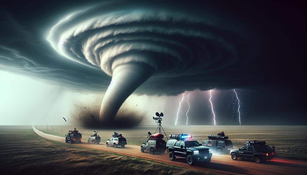
Tackling navigation challenges during storm chasing requires us to combine traditional map reading techniques with advanced GPS strategies and real-time weather pattern analysis. Mastering compass navigation and interpreting topographical maps are foundational. Leveraging GPS technology for real-time storm tracking and integrating this data with GIS platforms allows dynamic course adjustments. Analyzing atmospheric data via satellite imagery and Doppler radar ensures accurate storm predictions. Emergency route planning integrates live traffic updates, pre-planned detours, and GPS data for safety. Effective team communication with high-frequency radios and standardized codes is essential. Perfecting these techniques can significantly improve our storm chasing success.
Key Points
- Master compass navigation to align with topographical maps and anticipate elevation changes.
- Use GPS for real-time storm tracking and dynamic course adjustments, ensuring signal reliability.
- Analyze weather patterns using satellite imagery, Doppler radar, and numerical prediction models.
- Plan emergency routes with real-time data for road closures, detours, and swift path adjustments.
Map Reading Techniques
Let's dive into the fundamental map reading techniques that storm chasers rely on to accurately interpret topographical data and navigate challenging terrains. Mastering compass navigation is essential. We align the compass's base plate with a map's north-south grid lines, ensuring our direction of travel is precise. By adjusting the compass housing to match magnetic declination, we compensate for the variation between magnetic and true north, a key step for accurate bearings.
Landmark identification further enhances our navigational accuracy. We pinpoint prominent features like rivers, mountains, and man-made structures, cross-referencing them with our maps. This dual verification method—compass readings and visual landmarks—ensures we stay on course, even in the midst of severe weather conditions.
Topographical maps provide contours that indicate elevation changes, enabling us to anticipate and plan our routes through rugged terrain effectively. By interpreting contour intervals, we gauge the steepness of slopes and identify potential obstacles. Recognizing the symbology on these maps, such as vegetation and water bodies, helps us predict ground conditions, which is essential when plotting safe paths.
In essence, our proficiency in these techniques grants us the freedom to navigate with confidence, ensuring we reach our destinations safely and efficiently.
GPS Utilization Strategies
While traditional map reading techniques form the foundation of our navigation skills, incorporating GPS technology enhances our ability to track storm movements in real-time. By leveraging satellite tracking, we can pinpoint our location with remarkable accuracy, allowing us to adjust our course dynamically as weather conditions evolve. This precision is crucial when dealing with unpredictable storm paths, guaranteeing we can stay safe while gathering essential data.
To maximize the benefits of GPS, we must consider signal reliability. The integrity of our data hinges on the strength and consistency of satellite signals. In areas with dense cloud cover or rugged terrain, signal reliability can be compromised. Therefore, we often employ dual-frequency GPS receivers, which mitigate signal degradation and improve accuracy. This technology ensures we maintain precise navigation even under challenging conditions.
Furthermore, integrating GPS data with Geographic Information System (GIS) platforms provides us with thorough situational awareness. These systems enable us to visualize storm patterns and terrain features simultaneously, enhancing our strategic planning. The combination of satellite tracking and robust signal reliability empowers us to make informed decisions, guaranteeing our pursuit of freedom and adventure in storm chasing is both exciting and secure.
Weather Pattern Analysis
Analyzing weather patterns involves scrutinizing atmospheric data to predict storm development and movement accurately. We start by gathering real-time data from satellite imagery, Doppler radar, and weather balloons. This data interpretation helps us identify key variables such as humidity, wind speed, and pressure systems. By examining these variables, we can spot the conditions favorable for storm formation and potential trajectories.
We rely heavily on numerical weather prediction models, which use mathematical simulations to forecast weather changes. These models, like the Global Forecast System (GFS) and the European Centre for Medium-Range Weather Forecasts (ECMWF), provide us with essential insights into storm prediction. By comparing model outputs with current weather observations, we can refine our forecasts and reduce uncertainty.
Additionally, we utilize ensemble forecasting techniques. These involve running multiple scenarios with slightly varied initial conditions to assess a range of possible outcomes. This approach allows us to gauge the probability of different storm paths and intensities, making our predictions more robust.
Ultimately, our ability to interpret complex data and apply advanced forecasting models empowers us to navigate and chase storms effectively. By staying ahead of the storm's path, we maintain the freedom to explore and document these incredible natural phenomena safely.
Emergency Route Planning
Effective emergency route planning relies on real-time data integration and dynamic adjustment capabilities to safeguard our safety while tracking storms. We need to anticipate and respond to rapidly changing conditions with precision. Leveraging GPS and live traffic updates, we can identify road closures and detour options promptly.
Our strategy involves:
- Monitoring Live Data: Consistently updating our navigation tools guarantees we're informed of any road closures or new hazards that could obstruct our path. This real-time data is crucial for making well-informed decisions.
- Pre-Planning Alternate Routes: Prior to departure, we map out multiple alternative routes. This proactive approach enables us to switch paths swiftly without wasting valuable time. Familiarity with these routes allows us to adjust more quickly under pressure.
- Developing Thorough Evacuation Plans: Safety is paramount. We create detailed evacuation plans that account for various scenarios, ensuring we've a clear exit strategy from any location. This preparation means we're never caught by surprise.
Team Communication Essentials

Clear and concise team communication is essential for coordinating our movements and ensuring everyone's safety during a storm chase. We rely heavily on radio communication to maintain constant contact with each other.
Utilizing high-frequency radios, we can transmit and receive real-time updates, vital for adapting to rapidly changing weather conditions.
We utilize standardized signal codes to convey critical information quickly and efficiently. For instance, when we observe a tornado forming, we use the code 'T-Formation' to alert the team immediately. Similarly, 'R-Route' indicates a planned change in our navigation path due to road obstructions or deteriorating weather.
Our communication protocol includes predefined intervals for status updates, ensuring no team member becomes isolated. We also employ redundancy measures such as backup radio frequencies and satellite phones to mitigate the risk of communication breakdowns.
Frequently Asked Questions
How Do Storm Chasers Handle Encounters With Wild Animals During Their Expeditions?
In our expeditions, we handle animal encounters by prioritizing safety and avoidance. We study wildlife behavior, implement strict precautions, and use data-driven strategies to minimize risk, ensuring our freedom to chase storms remains unhindered.
What Kind of Vehicle Modifications Are Beneficial for Storm Chasing?
Our vehicle is our shield against nature's fury. Off-road tires and suspension upgrades are essential for storm chasing, providing stability and control. Enhanced durability and performance allow us to navigate treacherous terrains, ensuring our pursuit of freedom remains uninterrupted.
How Do Storm Chasers Manage Sleep and Rest Breaks During Long Chases?
We manage sleep and rest breaks using strategic sleep strategies and scheduled rest breaks. To combat fatigue, we implement fatigue management protocols and alertness techniques, ensuring we're always ready to chase storms while maintaining peak performance and safety.
What Are the Insurance Considerations for Storm Chasing Activities?
When we storm chase, liability coverage is vital to protect against potential damages or injuries. Equipment protection guarantees our gear's safety. Both are necessary to maintain our freedom to chase storms without incurring significant financial risks.
How Do Storm Chasers Maintain Their Mental Health Under Stressful Conditions?
Sailing through the stormy seas of stress requires strong mental resilience and effective stress management. We prioritize self-care and utilize various coping mechanisms to maintain mental health, ensuring we're always prepared to pursue freedom's horizon.