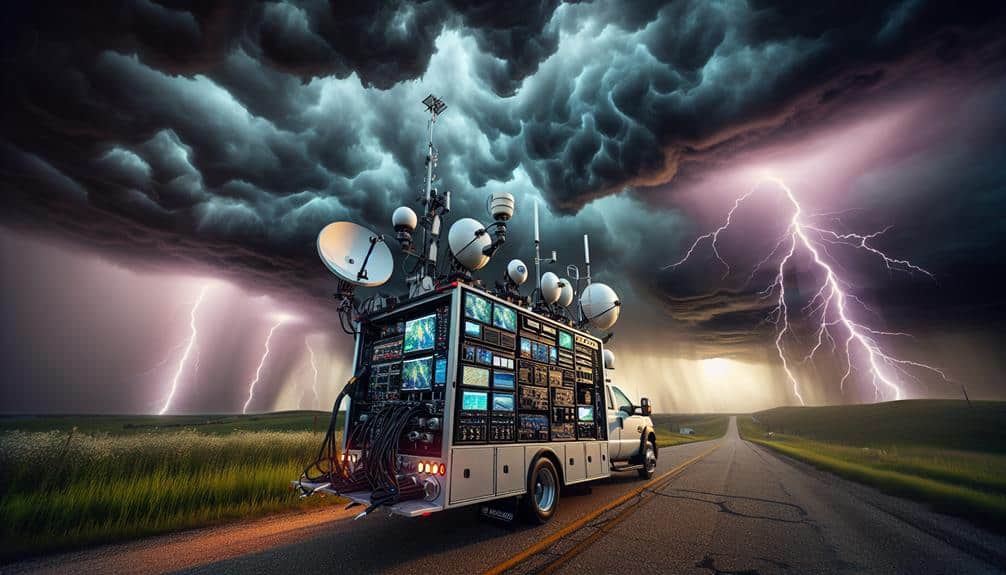
We equip storm chasing vans with advanced weather monitoring tools to collect real-time, high-resolution data, enhancing forecast accuracy and pinpointing storm paths. This data-driven approach supports strategic emergency response and mitigates risks for both our teams and the public. GPS integration and meteorological instruments enable precise location tracking, while real-time data contributes to dynamic models and predictive algorithms. Effective communication via satellite and mobile networks ensures coordinated efforts with meteorological centers. By converging technology and human expertise, we maximize safety, improve our understanding of storm development, and optimize decision-making processes. There's much more to uncover about our methodologies and tools.
Key Points
- Collect real-time, high-resolution data directly from storm systems to improve forecast accuracy.
- Enhance safety and risk mitigation through data-driven strategies and state-of-the-art monitoring instruments.
- Provide precise location tracking and storm path modeling using GPS and integrated tracking systems.
- Facilitate efficient communication and coordination with meteorological centers and emergency services.
Real-Time Data Collection
Real-time data collection is crucial for storm chasers, providing us with up-to-the-minute information on atmospheric conditions. We rely on advanced forecasting technology and data visualization tools to interpret vast amounts of meteorological data quickly. These tools enable us to track storm developments, including wind speeds, pressure changes, and precipitation patterns, with high accuracy.
By integrating real-time data feeds from radar systems, satellite imagery, and ground-based sensors, we can create dynamic visual representations of storm systems. This capability is essential for making informed decisions on positioning and movement, ensuring that we can observe storms closely while maintaining a safe distance.
Moreover, our real-time data collection efforts play a pivotal role in emergency response and public safety. The information we gather is shared with local authorities and meteorological agencies, aiding in the timely issuance of warnings and advisories. This collaborative approach helps communities prepare for severe weather events, potentially saving lives and reducing damage.
Safety and Risk Mitigation
Securing our safety and effectively mitigating risks during storm chasing necessitates a strategic approach grounded in rigorous data analysis and situational awareness. We need to perform continuous risk assessments, leveraging real-time data from our weather monitoring tools. This data-driven method allows us to anticipate potential dangers and make informed decisions quickly.
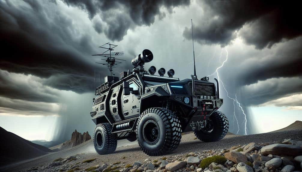
By examining atmospheric pressure, wind speed, and precipitation levels, we can predict storm movements and adjust our positioning to minimize exposure to hazardous conditions. Our vans are equipped with state-of-the-art weather monitoring instruments, providing critical information that enhances our situational awareness. This technology enables us to implement effective emergency response strategies.
For instance, if data indicates an imminent tornado, we can swiftly relocate to a safer area, adhering to pre-defined evacuation routes. By systematically analyzing the data, we can also determine the safest distance to maintain from the storm, guaranteeing we capture valuable observations without compromising our safety.
Freedom to chase storms comes with inherent risks, but through meticulous risk assessment and prompt emergency response, we can navigate these challenges. Our reliance on precise, real-time data guarantees that we remain agile and adaptive, prioritizing our safety while pursuing our passion.
Precise Location Tracking
We utilize GPS technology to accurately track storm paths, ensuring our vans are positioned for best data collection.
Real-time data transmission allows us to analyze storm behavior instantaneously, improving our predictive models.
GPS for Storm Paths
Utilizing GPS technology enables us to accurately track storm paths and precisely pinpoint locations, thereby enhancing our ability to predict and respond to severe weather events. By integrating GPS with our storm tracking systems, we achieve a high level of precision that's essential for effective emergency response. This technology allows us to map the trajectory of storms in real-time, providing critical data on speed, direction, and intensity.
When we deploy storm chasing vans equipped with GPS, we gain the ability to monitor storm movements with pinpoint accuracy. This precise location tracking is crucial for issuing timely warnings and mobilizing resources where they're needed most. During severe weather events, every second counts, and GPS technology ensures we maximize our response efficiency.
Moreover, the data collected through GPS enables us to create detailed storm path models. These models are essential for analyzing storm behavior patterns and improving predictive algorithms. The more accurately we can predict a storm's path, the better we can inform communities and emergency services, ultimately enhancing public safety and minimizing damage.
In essence, GPS technology isn't just about tracking storms; it's about empowering us to act swiftly and effectively in the face of nature's most unpredictable forces.
Real-Time Data Collection
How can we leverage real-time data collection to achieve precise location tracking during storm events?
By equipping our storm chasing vans with advanced weather monitoring tools, we can collect high-resolution data on storm paths, wind speeds, and atmospheric conditions. These tools provide live updates, enhancing our ability to track storms with pinpoint accuracy.
Our approach utilizes a combination of GPS technology and a suite of meteorological instruments. The integration of these systems guarantees data accuracy, offering us real-time insights into the storm's trajectory. This continuous stream of precise data allows us to adjust our position dynamically, making sure we stay within the best range for data collection without compromising safety.
Moreover, live updates from these tools enable us to share critical information with weather agencies and emergency services in real-time. This collaborative effort enhances public safety by enabling timely warnings and efficient resource allocation.
By prioritizing data accuracy and real-time monitoring, we're not just chasing storms; we're contributing to a broader understanding of severe weather patterns and improving community resilience against natural disasters.
In essence, real-time data collection isn't just a tool; it's a lifeline that empowers us to navigate and decode the complexities of storm phenomena.
Enhanced Forecast Accuracy
Storm chasing vans equipped with advanced weather monitoring tools greatly enhance forecast accuracy by providing real-time data from within storm systems. This improved technology allows us to collect high-resolution, localized data, which is critical for refining predictive models. By capturing parameters such as atmospheric pressure, temperature gradients, and wind speed directly from the storm, we can significantly boost forecasting accuracy.
Consider these advantages we gain from using storm chasing vans:
- Real-time data collection: Unlike stationary weather stations, our vans move directly into the path of the storm, offering immediate updates.
- High-resolution measurements: Onboard sensors capture minute-by-minute changes, offering more precise data points for our models.
Research and Analysis
Our research and analysis focus on interpreting the high-resolution data collected by our storm chasing vans to develop more precise predictive weather models. By carefully examining the data, we can identify key atmospheric variables such as wind speed, temperature gradients, and humidity levels that contribute to severe weather events. This data analysis allows us to pinpoint the exact conditions under which storms develop and intensify.
Through our rigorous analytical approach, we extract meaningful patterns from vast datasets, enhancing our understanding of storm dynamics. These insights are essential for improving existing weather prediction algorithms. The research benefits are manifold; not only do we gain a more nuanced understanding of meteorological phenomena, but we also empower communities to make informed decisions during severe weather conditions.
We employ sophisticated statistical tools and machine learning algorithms to process the data in real-time. This guarantees that our predictive models remain responsive and adaptable to changing weather patterns. Our commitment to data-driven research underscores the importance of precision and accuracy, ultimately contributing to greater public safety and resilience.
Communication and Coordination
To maximize the impact of our advanced predictive weather models, we prioritize seamless communication and coordination among our storm chasing teams and meteorological experts. A streamlined flow of real-time data and situational awareness is crucial for effective team coordination and efficient emergency response. Our communication systems are designed to integrate multiple data sources, making sure that every team member is informed and ready to act.
We utilize a multi-channel approach for robust communication:
- Satellite and radio communication: Enables real-time updates even in remote locations.
- Mobile data networks: Provide continuous internet access for up-to-the-minute weather data and predictive models.
These tools aren't just about data gathering; they're about making swift, informed decisions that can save lives.
By maintaining constant communication, we can reallocate resources, adjust paths, and provide timely warnings to affected communities. Coordinated efforts between our storm chasing vans and meteorological centers are essential for delivering accurate forecasts and activating emergency response protocols.
This synergy between technology and human expertise empowers us to pursue our mission with precision and adaptability, ensuring resilience from the unpredictability of severe weather.
Frequently Asked Questions
How Do Storm Chasers Get Funding for Their Equipment and Operations?
We face Herculean challenges in securing funding sources, but we succeed through sponsorship opportunities and partnerships. Analytical data-driven proposals help us attract backers, ensuring our operations maintain the freedom to pursue groundbreaking storm research and safety initiatives.
What Training Is Required to Become a Professional Storm Chaser?
To become professional storm chasers, we need meteorology expertise and advanced driving skills. Data indicates formal education in atmospheric sciences and practical training in high-stress driving conditions greatly enhance our safety and effectiveness in the field.
Are There Specific Seasons or Regions Where Storm Chasing Is More Common?
You might think storm chasing is random, but we actually focus on peak seasons and specific regions. Safety precautions and technology advancements are important in these areas, allowing us the freedom to gather accurate data efficiently.
How Do Storm Chasers Handle Vehicle Maintenance During Long Expeditions?
We handle vehicle maintenance during long expeditions by adhering to strict safety precautions and emergency protocols. Regular checks on tires, engine, and essential systems guarantee reliability, allowing us the freedom to chase storms without unnecessary risks.
What Legal Permissions Are Needed to Chase Storms in Various Areas?
When storm chasing in Texas, we need legal permissions due to strict storm chasing regulations. We must adhere to local guidelines and restrictions to guarantee safety and compliance. Ignoring these can result in fines or revoked privileges.