When predicting storm formations, we rely on evaluating weather models using extensive datasets including temperature, humidity, wind speed, and atmospheric pressure. We cross-reference these with historical records and utilize ensemble forecasting for accuracy. Real-time satellite, radar, and sensor data enhance precision. Analyses of meteorological patterns like El Niño and interpreting radar reflectivity and velocity for storm structure are essential. Satellite imagery and atmospheric sounding data offer insights into vertical profiles and moisture content. Deploying drones for high-resolution monitoring and combining these techniques helps us provide thorough storm predictions. Discover how we use these methods to stay ahead of the storm.
Key Points
- Utilize radar data to identify precipitation intensity, wind patterns, and rotational signatures indicative of storm development.
- Cross-reference real-time weather data with historical records to recognize patterns and predict storm formations.
- Employ satellite imagery to monitor cloud formations and temperature variations for early storm detection.
- Analyze atmospheric sounding data to understand vertical profiles and potential instability leading to storm development.
Analyzing Weather Models
When analyzing weather models, we must thoroughly evaluate the accuracy and reliability of their predictive algorithms. These models are essential for storm tracking and weather prediction, enabling us to anticipate severe weather events and act accordingly.
We start by gathering an extensive dataset, which includes temperature, humidity, wind speed, and atmospheric pressure. Our data analysis involves cross-referencing this data with historical records to identify patterns and anomalies. Advanced forecasting techniques, such as ensemble forecasting, allow us to run multiple simulations to assess the likelihood of various outcomes.
By comparing these simulations, we can determine the model's reliability and pinpoint potential inaccuracies. In storm tracking, real-time data is vital. We integrate data from satellites, radar, and ground-based sensors to update our models continuously. This dynamic approach enhances our ability to predict storm formations with greater precision.
The use of machine learning algorithms further hones our predictive capabilities by identifying subtle trends that may not be immediately apparent. Ultimately, our goal is to provide precise and timely weather forecasts that empower individuals to make informed decisions.
Identifying Atmospheric Patterns
Identifying atmospheric patterns requires a detailed analysis of meteorological data to discern the underlying mechanisms that drive storm formations. We begin by examining key variables such as temperature, humidity, wind speed, and atmospheric pressure at various altitudes. These parameters help us identify specific climate patterns that correlate with storm development. For instance, the presence of a low-pressure system often indicates rising air, a vital factor for storm genesis.
By analyzing historical climate patterns, we can recognize recurring weather phenomena like El Niño or La Niña, which greatly influence storm activity. Satellite imagery provides us with visual data, helping us track the movement of air masses and the development of cloud formations. Additionally, we rely on atmospheric sounding data collected by weather balloons to get a vertical profile of the atmosphere, offering insights into stability and moisture content.
The integration of these diverse datasets allows us to create a detailed picture of the current atmospheric conditions. Our goal is to decode these patterns accurately to predict the likelihood and intensity of storm formations. By doing so, we empower ourselves with the knowledge to anticipate severe weather events, making informed decisions that enhance our freedom to chase storms safely and effectively.
Interpreting Radar Data
Interpreting radar data involves analyzing the reflectivity and velocity of radar signals to understand precipitation patterns and storm dynamics. By examining reflectivity, we can determine the intensity and type of precipitation, distinguishing between rain, snow, and hail. Higher reflectivity values often indicate heavier precipitation, which is vital for storm prediction.
In radar interpretation, velocity data allows us to detect wind patterns and rotational signatures within a storm. This is particularly significant for storm tracking, as it helps us identify potential tornado formations. By analyzing the Doppler shift in radar returns, we can pinpoint areas of high wind shear and rotation.
Data analysis is at the heart of accurate storm prediction. By combining reflectivity and velocity data, we can build a thorough picture of storm structure and movement. For instance, a hook echo in the reflectivity data, combined with a velocity couplet, is a strong indicator of a developing tornado.
Our ability to interpret radar data empowers us to make informed decisions and provide timely warnings. With precise radar interpretation and thorough data analysis, we can track storms more effectively, ensuring safety and freedom for everyone in the storm's path.
Utilizing Satellite Imagery
In addition to radar data, satellite imagery provides us with a detailed view of storm systems, capturing cloud formations, temperature variations, and moisture content to enhance our understanding of storm development. Utilizing this resource, we can observe storm dynamics from a broader perspective, which is vital for accurate predictions.
Satellite coverage allows us to monitor several key elements:
- Cloud Formations: By analyzing cloud structures, we can identify potential storm systems. Cumulonimbus clouds, for instance, often indicate severe weather conditions.
- Temperature Variations: Infrared satellite imagery helps us detect temperature differences at various atmospheric levels, essential for understanding convection processes.
- Moisture Content: Water vapor imagery gives insight into the moisture available in the atmosphere, an important factor for storm intensification.
Field Observation Techniques
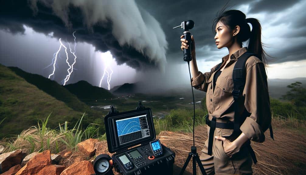
Field observation techniques play an important role in collecting real-time data that enhances our understanding of storm behavior. By deploying drone surveillance, we can capture high-resolution imagery and video footage of storm systems from altitudes that are otherwise inaccessible. This technology allows us to gather crucial data on wind speeds, temperature gradients, and moisture levels, which are essential for accurate storm tracking and predictive modeling.
Equipped with advanced sensors, our drones can relay information instantaneously, providing us with a dynamic view of storm development. This real-time data collection enables us to make timely decisions and issue warnings, maximizing public safety.
Storm photography, another vital technique, helps us document visual changes in storm structure, such as the formation of wall clouds and tornado genesis. High-quality images taken at various stages of storm evolution provide valuable data points for post-event analysis and model validation. These photographs aren't just aesthetic; they serve as empirical evidence that can refine our predictive algorithms.
Combining these field techniques, we elevate our storm tracking capabilities, ensuring we capture comprehensive, actionable data. These methods empower us to chase storms with precision and responsibility, ultimately enhancing our ability to forecast severe weather events.
Frequently Asked Questions
How Can I Ensure My Safety While Storm Chasing?
When we chase the whirlwind, let's anchor our safety with solid precautions and detailed emergency plans. We should monitor real-time data, use GPS for navigation, and always have a reliable communication system to guarantee our freedom and security.
What Equipment Is Essential for a Beginner Storm Chaser?
For beginner storm chasers, essential equipment includes camera gear for documenting events and communication devices for real-time updates. We need reliable GPS, weather radios, and mobile data to track and safely navigate severe weather conditions.
How Do I Join a Storm Chasing Community or Team?
Imagine the thrill of chasing storms together. To join a storm chasing community, we recommend finding mentors through online forums and social media. Building connections at meteorological conferences fosters trust and camaraderie essential for successful chases.
Are There Any Legal Restrictions on Storm Chasing?
Legal considerations and permissions are essential in storm chasing. We must adhere to storm chasing laws and regulations, including traffic laws and restricted zones, ensuring our safety and respecting local authorities while pursuing our passion for freedom.
To document and share our storm chasing experiences effectively, we should utilize advanced video editing software for high-quality footage and leverage social media platforms for real-time updates, engaging posts, and data-driven insights to captivate our audience.


