You’re looking at NOAA’s P-3 Orion aircraft—a 117-foot turboprop engineered to penetrate hurricane eyewalls while collecting critical meteorological data. The aircraft carries up to 22 crew members who deploy GPS dropwindsondes, operate tail-mounted Doppler radar, and transmit real-time atmospheric measurements to the National Hurricane Center. Four turboprop engines power flights through 240 mph winds, with data improving forecast accuracy by 10-15%. These missions have corrected storm trajectories by hundreds of miles, directly protecting coastal communities through enhanced early warning systems and precision intensity assessments.
Key Takeaways
- The P-3 Orion is 117 feet long with a 100-foot wingspan, powered by four turboprop engines delivering 4,600 shp each.
- The aircraft carries up to 22 crew members and 57,800 pounds of mission-critical gear for hurricane reconnaissance operations.
- Tail-mounted Doppler radar and lower fuselage radar provide complete 3D wind field analysis and eyewall imaging during penetration.
- GPS dropwindsondes deployed from the aircraft’s belly transmit temperature, pressure, humidity, and wind data four times per second.
- Hurricane Hunter data improves forecasts by 10-15% and has corrected storm trajectories by hundreds of miles.
Meet Kermit and Miss Piggy: NOAA’s Hurricane-Hunting Fleet
While most aircraft avoid severe weather, NOAA’s twin Lockheed WP-3D Orion turboprops—nicknamed Kermit (N42RF) and Miss Piggy (N43RF)—fly directly into it. Their iconic livery features characters from Jim Henson Productions through a brand collaboration that’s become synonymous with hurricane research.
These four-engine multifunction scientific research platforms serve as the backbone of America’s civilian hurricane hunter fleet. You’ll find them equipped with specialized lower fuselage and tail Doppler radars—systems unique among U.S. hurricane surveillance aircraft. They complement NOAA’s Gulfstream IV-SP (Gonzo) and USAF WC-130s during storm operations.
From Commercial Airliner to Storm Chaser: The Lockheed Connection
The WP-3D aircraft you see hunting hurricanes today trace their lineage directly to Lockheed’s Model 188 Electra commercial airliner, adapted for maritime patrol before NOAA acquired them from the production line in 1976.
These airframes weren’t simply repurposed—they underwent extensive structural reinforcement to withstand the extreme turbulence and stress of penetrating hurricane eyewalls at low altitude.
The commercial design’s inherent stability and range capabilities, originally intended for civilian passengers, now enable NOAA crews to conduct extended research missions in the world’s most violent storms.
L-188 Electra Origins
Born from American Airlines’ specifications for a medium-range turboprop airliner, the Lockheed L-188 Electra rolled out of Lockheed Air Terminal in California on December 6, 1957—56 days ahead of schedule. You’re looking at commercial airliner origins that would fundamentally reshape maritime patrol aviation.
Powered by four Allison 501-D13 turboprop engines delivering 3,750 shaft horsepower each, the Electra achieved cruise speeds of 373 mph with exceptional fuel efficiency. However, structural and flight issues emerged in 1959 when crashes revealed wing-nacelle design flaws causing catastrophic gyroscopic whirl mode forces.
Lockheed’s thorough fixes—stronger wing structures and thicker skins—preserved the airframe’s integrity. The Navy recognized this robust platform’s potential, adapting the proven design into the P-3 Orion by shortening the forward fuselage while retaining critical systems and crew space.
1970s NOAA Acquisition
Facing budget constraints and aging DC-6 aircraft that couldn’t meet evolving research demands, NOAA made a decisive acquisition choice in 1973. The decision-making factors centered on proven reliability and operational capability—leading to the selection of USN P-3 Orions fresh from Lockheed’s production line.
You’ll appreciate the funding challenges NHRL and RFF confronted: they implemented staff reductions, belt-tightening measures, and cancelled three years of STORMFURY flights to finance the purchase.
The first WP-3D arrived in 1975, followed by its twin in 1976. Each aircraft came equipped with cutting-edge computers and three radar antennas, immediately improving field data quality.
When the USN deactivated its hurricane reconnaissance squadrons in 1975, these NOAA aircraft assumed critical operational duties alongside USAF platforms—ensuring continuous tropical cyclone monitoring capabilities.
Reinforced for Research Missions
Adapted from Lockheed’s L-188 Electra commercial airliner, the P-3 Orion underwent extensive modifications to transform passenger transport into hurricane research platform. Engineers shortened the fuselage by seven feet forward of the wing, reducing weight while preserving critical space for flight crew and sensors.
The structural modifications enabled your aircraft to support twelve-person crews and bulky electronics without compromising flight safety.
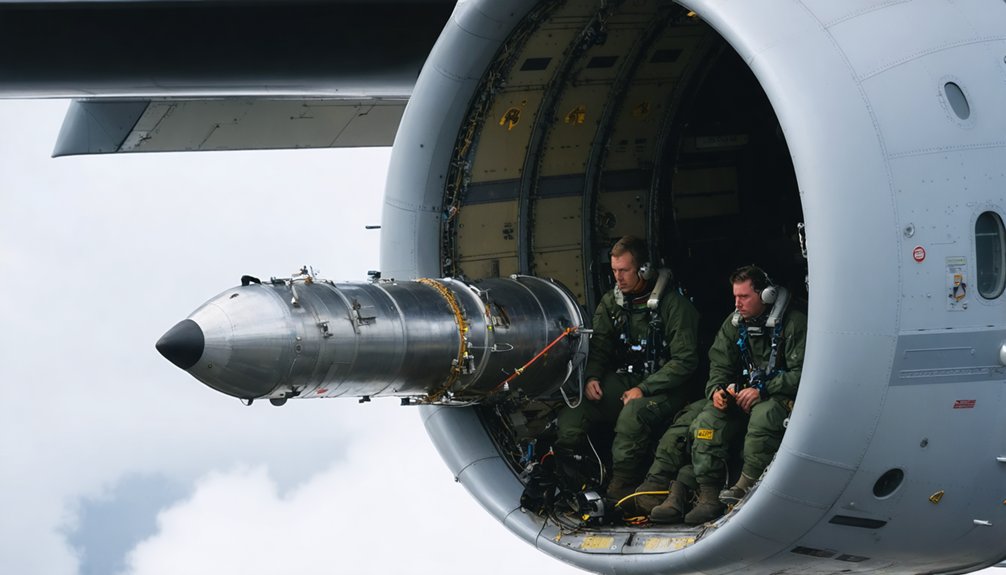
The bomb bay became equipment housing for research instrumentation rather than military ordnance. Reinforced decks accommodate heavy sensor loads, while the extended tail stinger houses scientific instruments instead of submarine-detection equipment.
This four-engine turboprop configuration delivers the endurance and reliability you’ll need during extended storm missions. Every modification serves one purpose: getting you safely into hurricanes and back with actionable data that saves lives.
Built for the Mission: Physical Specifications and Capabilities
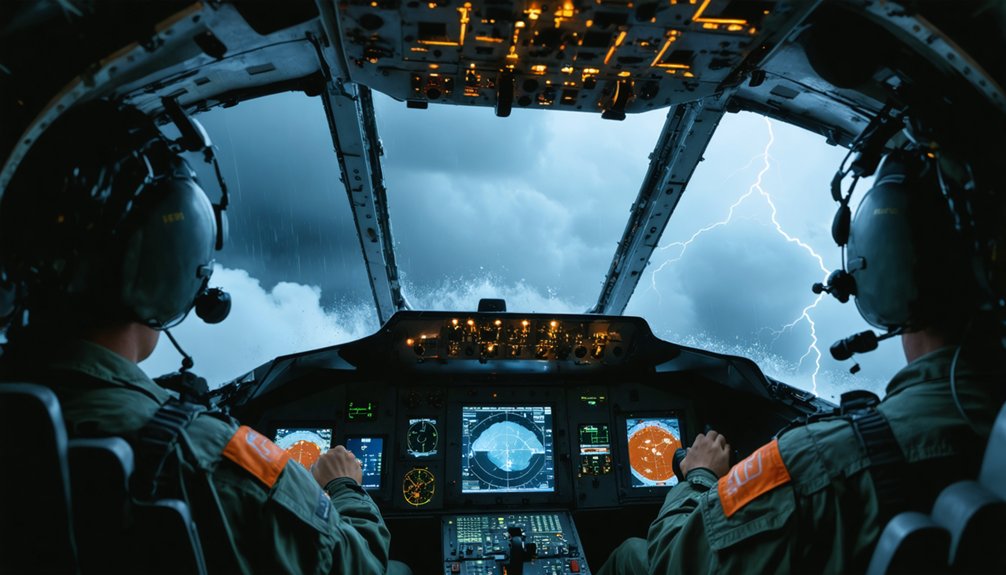
At nearly 117 feet long with a 100-foot wingspan, NOAA’s P-3 Orion serves as a flying meteorological laboratory purpose-built to penetrate the most violent storms on Earth. This aircraft configuration supports up to 22 crew members—including three pilots, two flight engineers, and twelve scientists—who operate sophisticated weather surveillance equipment during missions lasting up to 11.5 hours.
The structural reinforcements enable the P-3 to carry 57,800 pounds of mission-critical gear while maintaining a service ceiling of 28,300 feet. You’ll find C-band and X-band weather radars mounted in the nose, fuselage, and tail, complemented by GPS dropsondes and Step Frequency Microwave Radiometers. The reinforced deck supports additional sensor arrays, allowing your team to gather pressure, temperature, humidity, and wind data directly from nature’s most powerful phenomena.
Power Through the Storm: Engine Performance and Flight Range

Four Allison T56-A-14 turboprop engines transform the P-3 Orion into a storm-penetrating powerhouse, each delivering 4,600 shaft horsepower through four-bladed Hamilton Standard propellers. NOAA’s WP-3D variants utilize Rolls-Royce T56-14 Series 3.5 engines producing 4,500 shp, propelling the aircraft to maximum speeds of 411 knots while cruising efficiently at 328 knots.
You’ll find the P-3’s 8,955-gallon fuel capacity enables 4,830 nautical miles ferry range. During hurricane missions, fuel saving strategies become critical—crews employ reduced engine operations by shutting down the left outer engine during on-station loiter. This technique extends patrol endurance beyond 12 hours while maintaining surveillance capability at low altitude.
The service ceiling reaches 28,300 feet, allowing rapid transit above weather systems between operational areas.
The Crew Behind the Science: 22 Specialists Working in Harmony
You’ll find up to 22 highly trained specialists working in synchronized precision aboard each P-3 mission, transforming raw atmospheric data into life-saving hurricane intelligence.
The flight deck operations team maintains aircraft control through severe turbulence while scientists deploy dropwindsondes and collect critical measurements that fill gaps in radar and satellite coverage.
Engineering specialists continuously monitor aircraft systems and calibrate scientific instruments, ensuring mission success during grueling 8-10 hour flights through Category 5 storms.
Flight Deck Operations Team
When a P-3 Orion launches into a hurricane’s violent core, it carries 22 specialists whose coordinated expertise transforms extreme danger into actionable science. Your flight deck operations team includes NOAA Corps pilots, civilian flight engineers, meteorologists, and electronic engineers—each role critical to mission success.
Mission planning begins with thorough pre-flight briefs where the Flight Director reviews routes, objectives, and storm hazards.
During 9-10 hour reconnaissance flights, crew coordination becomes paramount as pilots navigate through extreme turbulence while specialists maintain real-time communication. The Flight Director strategizes pattern modifications based on evolving conditions, coordinating with agencies like NASA and the Office of Naval Research.
This disciplined structure guarantees you’ll capture essential data while maintaining aircraft safety—even when conditions ground conventional flights.
Scientific Data Collection Specialists
Behind every successful hurricane penetration flight, specialized data collection teams transform raw atmospheric measurements into forecast-saving intelligence.
You’ll find five distinct specialist roles working the science mission:
- Dropsonde Operators deploy expendable instruments tracking pressure, temperature, humidity, and winds while monitoring release positions relative to the storm center
- Data Quality Control Specialists process data through Aspen software, ensuring accuracy before transmission via Global Telecommunication System for storm trajectory analysis
- Instrument Deployment Technicians launch GPS dropwindsondes that provide superior in-situ measurements compared to satellite remote sensing
- Research Data Analysts feed National Hurricane Center forecast models while advancing Hurricane Research Division’s understanding of intensity changes
- Mission Science Coordinators brief routes, determine instrument installations, and maintain environmental data quality standards
Their coordinated efforts enable accurate predictions for evacuations and warnings.
Engineering and Systems Monitoring
While dropsonde operators and data analysts capture the scientific measurements, three critical engineering roles guarantee the P-3 Orion remains airborne through 175-mph eyewall winds. Your flight engineer responsibilities center on monitoring airspeed, engine conditions, and analog engine stacks during extreme turbulence.
You’ll track upflow, outflow, and wave patterns in the eyewall structure, providing real-time oversight beyond the pilots’ immediate focus. This four-engine vigilance proves essential when penetrating the storm’s most violent sectors.
Systems instrumentation upgrades transformed the P-3s since 1975. You’re working with three radar antennas, advanced computers, and Knollenberg cloud physics probes installed post-1981. The tail radar’s 1982 Doppler processing enhancement delivers critical vortex dynamics.
Your Forward Scattering Spectrometer Probe compiles instantaneous particle size statistics, capturing real-time images of precipitation types passing through the laser diode array.
Radar Systems That See Inside the Storm
At the heart of hurricane reconnaissance, the P-3 Orion’s three radar antennas transform invisible wind patterns into precise data that meteorologists depend on for storm analysis. You’re witnessing cutting-edge technology that reveals what satellites can’t see—the storm’s internal machinery.
The tail-mounted Doppler radar scans vertically through the storm, enabling complete 3D wind field analysis of the hurricane’s inner core. Meanwhile, the lower fuselage radar sweeps horizontally from the aircraft’s belly, imaging the eyewall ahead during your penetration at altitudes between 500 and 10,000 feet.
These systems deliver critical intelligence:
- Real-time vertical and horizontal storm structure mapping
- Precise storm core dynamics during eyewall replacement cycles
- Wind field measurements beyond your direct flight track
- Center location and intensity assessment for forecasters
You’re collecting data that protects lives onshore.
Dropwindsondes and Cutting-Edge Sensing Technology
Each hurricane penetration demands precise atmospheric measurements that only one technology can deliver: GPS dropwindsondes. You’re witnessing these instruments plummet from the P-3’s belly, parachutes deployed, transmitting temperature, pressure, humidity, and wind data four times per second until ocean impact. Enhanced deployment techniques now include minisondes—enabling 50 simultaneous launches through magnetic triggers—and StreamSondes weighing just 14 grams, descending without parachutes at 5 meters per second for extended observation windows.
Advanced data analysis begins immediately. Your dropsonde operator quality-checks transmissions in real-time, relaying critical measurements to the National Hurricane Center. This system improves forecasts by 10-15%, correcting storm trajectories by hundreds of miles.
In 2020 alone, operators deployed 2,700+ dropsondes, recording wind speeds reaching 240 mph—data that transforms uncertain predictions into actionable intelligence.
Flying Into the Eye: Mission Operations and Flight Patterns
Before the P-3 Orion’s engines roar to life, your Aircraft Commander has already mapped every entry and exit vector through the hurricane’s rotating wall of destruction.
Before you ever board the aircraft, your mission plan is already finalized—every storm penetration calculated, every exit route secured.
You’ll spend 9-10 hours cutting through eyewalls with 18-20 crew members, experiencing the storm dynamics impact firsthand—howling winds, blinding rain, and violent vertical currents that test your composure as much as your training.
Your mission success depends on:
- Weatherradar integration from tail Doppler and lower fuselage systems providing real-time storm structure visualization
- Constant coordination between Aircraft Commander, Flight Director, and Flight Engineer maintaining ideal airspeed and altitude
- Multiple eyewall penetrations before reaching the relative calm of the eye
- Six consecutive mission days during slow-moving storm operations
The 2018 dual-ring flight pattern enhancement brought you closer to the core, demonstrably improving forecast accuracy.
From Aircraft to Forecast: Real-Time Data Transmission

Your crew’s dangerous flight through hurricane eyewalls serves a single purpose: transmitting actionable data to forecasters who’ll issue warnings that save lives. Every 15 minutes, satellite links beam consolidated measurements from dropwindsondes, radar systems, and SFMRs directly to the National Hurricane Center.
Data aggregation occurs at the aircraft’s console, where specialized quality control software corroborates dropsonde readings before transmission. Transmission reliability remains critical—dual recording systems with backup power guarantee no information’s lost if primary systems fail.
Forecasters receive your observations in near real time, immediately integrating them into numerical weather prediction models. This seamless flow from aircraft to forecast model transforms raw atmospheric measurements into improved track predictions and intensity forecasts. Your StreamSonde deployments, SFMR wind readings, and Doppler-derived wind fields become the foundation for evacuation decisions affecting millions.
Beyond Hurricanes: Global Environmental Research Missions
While hurricanes dominate headlines, the P-3 Orion fleet’s mission extends far beyond tropical cyclones into diverse environmental research that shapes our understanding of Earth’s interconnected systems.
You’ll find these aircraft conducting critical investigations across multiple scientific domains:
- Atmospheric gas composition measurements tracking aerosols and chemical changes over transatlantic flight paths
- Seafoam radiation studies using Step Frequency Microwave Radiometers to probe wind speeds and sea surface conditions
- Winter storm research along Pacific coastal regions and severe convective complexes throughout the U.S. Midwest
- Ocean temperature profiling through airborne expendable bathythermographs deployed during low-altitude missions
For five decades, these proven airframes have participated in international collaborative programs, gathering environmental data that protects natural assets and advances climate modeling. Their specialized instrumentation transforms atmospheric and oceanographic monitoring into actionable intelligence for public safety.
Frequently Asked Questions
How Do Pilots Train to Fly Safely Through Hurricane Conditions?
You’ll forge your skills through the fire of actual hurricane flights, where crew communication and aircraft preparation become second nature. Repeated eyewall penetrations teach you real-world responsiveness that simulators can’t replicate, ensuring you’re mission-ready.
What Does It Feel Like Inside the Aircraft During Turbulence?
You’ll experience intense g-forces as the aircraft shakes violently in all directions, with abrupt altitude changes from sudden wind shifts. Equipment must be secured, seatbelts fastened tight, and head movement minimized to prevent motion sickness during the turbulent penetration.
How Many Hurricanes Does Each Aircraft Investigate per Season?
You’ll find each P-3 investigates multiple storms annually, with the average number of hurricane missions per aircraft varying by season intensity. The typical number of flights per hurricane ranges from three missions, as demonstrated during Hurricane Patricia’s surveillance operations.
What Is the Typical Career Path to Become a Hurricane Hunter?
Like climbing a ladder through storm clouds, you’ll need rigorous pilot qualifications and extensive aviation experience—typically accumulating 5-10 years through Air Force Reserve C-130 training or NOAA’s civilian path requiring advanced degrees and significant flight hours.
How Much Does It Cost to Operate One Hurricane Mission?
Specific aircraft operating costs per mission aren’t publicly disclosed, but you’ll find mission funding requirements drawn from NOAA’s $25 million hurricane forecasting allocation, covering fuel, maintenance, crew, and expendable equipment like $15,000 Coyote drones deployed during flights.