We need to comprehend five critical factors driving hurricane formation. First, warm ocean water exceeding 26.5°C provides the essential energy. Second, atmospheric pressure dynamics, particularly low-pressure areas, enhance storm intensity. Third, the Coriolis Effect, due to Earth's rotation, causes the distinctive cyclonic rotation. Fourth, moisture and heat exchange from ocean evaporation and condensation intensifies hurricane strength. Finally, the eye and eyewall structure, with its violent wind patterns and strong updrafts, indicates a hurricane's power. Understanding these principles helps us predict and mitigate hurricane impacts more effectively, leading to deeper insights into storm behaviors and forecasts.
Key Points
- Warm ocean waters exceeding 26.5°C provide the energy necessary for hurricane formation and growth.
- Low-pressure areas and pressure gradients create updrafts, which are crucial for developing storm intensity.
- The Coriolis Effect, caused by Earth's rotation, is essential for initiating and maintaining the cyclonic rotation of hurricanes.
- Moisture and heat exchange, from ocean evaporation and convection, fuel the development and strength of hurricanes.
The Role of Warm Water
Warm ocean water is the primary energy source that drives the formation and intensification of hurricanes. We recognize that the interplay between ocean currents and warm water layers is pivotal in this process. Ocean currents distribute heat around the globe, creating regions where water temperatures exceed the threshold needed for hurricane development.
When the sea surface temperature surpasses approximately 26.5°C (80°F), it provides the necessary thermal energy for evaporation and convection, fueling the storm's growth.
Climate change exacerbates this situation by increasing sea surface temperatures and altering ocean currents. As we continue to emit greenhouse gases, the Earth's atmosphere traps more heat, which is absorbed by the oceans. This not only raises the average temperature of ocean waters but also affects the patterns and strengths of ocean currents. Consequently, regions that were previously too cool for hurricane formation may now become suitable breeding grounds for these powerful storms.
Atmospheric Pressure Dynamics
Atmospheric pressure dynamics play a vital role in the development and intensification of hurricanes by influencing wind patterns and vertical air movements. When we examine how hurricanes form, we must consider the pressure gradients that exist within the atmosphere. These gradients, which are differences in atmospheric pressure between two points, drive the wind patterns essential for hurricane formation.
In regions of low pressure, air converges and rises, creating an updraft. As this air ascends, it cools and condenses, forming clouds and releasing latent heat. This process further reduces surface pressure, reinforcing the low-pressure system and enhancing the cyclone's intensity. Conversely, areas of high pressure tend to suppress such vertical movements, acting as barriers to hurricane formation.
Understanding wind patterns is essential because they dictate how air circulates around these pressure systems. In a developing hurricane, surface winds spiral inward towards the low-pressure center, while upper-level winds diverge outward. This arrangement allows for continuous upward movement of air, sustaining the cyclone.
Coriolis Effect Explained
To fully understand how hurricanes achieve their rotation and structure, we must examine the Coriolis Effect, which influences wind patterns and trajectories. The Coriolis Effect results from the Earth's rotation, causing moving air to deflect to the right in the Northern Hemisphere and to the left in the Southern Hemisphere. This deflection is essential for the cyclonic rotation observed in hurricanes.
By analyzing global wind patterns, we see that the Coriolis Effect significantly affects the movement of air masses. As air flows from high-pressure to low-pressure areas, it doesn't travel in a straight line but rather follows a curved path. This curvature is vital in initiating the rotation of storm systems, including hurricanes. Without the Coriolis Effect, these systems wouldn't develop the distinctive spiral structure that characterizes them.
For effective hurricane tracking, understanding the Coriolis Effect is indispensable. It helps meteorologists predict the path and behavior of hurricanes by accounting for the deflection of wind patterns. By factoring in the Coriolis Effect, we can more accurately model and anticipate the trajectories of these powerful storms, thereby enhancing our ability to prepare and respond.
This knowledge empowers us to protect our communities and navigate the challenges posed by these natural phenomena.
Moisture and Heat Exchange
In the intricate process of hurricane formation, moisture and heat exchange between the ocean surface and the atmosphere play a crucial role in fueling and sustaining these powerful storms. As warm ocean water evaporates, it increases the humidity in the lower atmosphere. This moisture-laden air rises due to convection, where it cools and condenses, releasing latent heat. This heat release warms the surrounding air, causing it to rise further and create a low-pressure area at the surface.
This continuous cycle of rising warm air and the subsequent condensation leads to significant energy transfer, which is essential for storm development. The energy released during condensation powers the hurricane, intensifying its strength and structure.
As the warm, moist air spirals inward, it feeds the storm, perpetuating the cycle of convection and energy transfer.
Humidity variations across the ocean surface also influence the intensity and development of the storm. Regions with higher humidity provide more fuel for the hurricane, leading to stronger and more sustained systems. Understanding how these processes interconnect helps us grasp the fundamentals of hurricane dynamics and the crucial role that moisture and heat exchange play in their formation and intensification.
Eye and Eyewall Structure
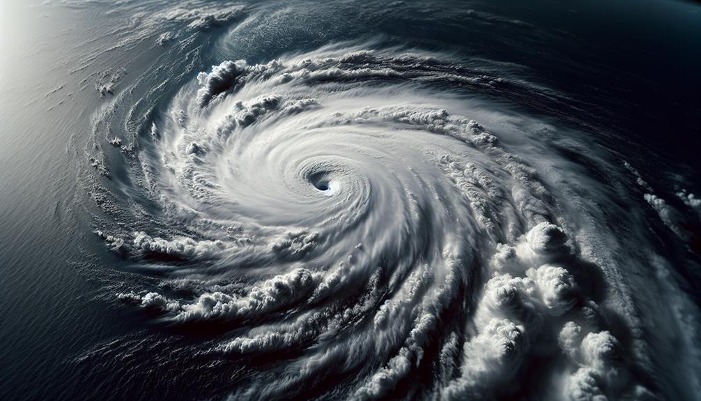
At the heart of a hurricane lies the eye, a calm, clear region surrounded by the intense winds and thunderstorms of the eyewall. This stark contrast is essential to understanding hurricane dynamics. The eye typically spans 20-40 miles in diameter and features light winds and relatively clear skies. Surrounding this tranquil center is the eyewall, where the most violent wind patterns and torrential rains occur.
We can observe that the eyewall's structure is pivotal for storm development. The strong updrafts and converging winds in this region drive the overall energy of the hurricane. As warm, moist air rises within the eyewall, it cools and condenses, releasing latent heat. This process fuels the storm, causing the wind speeds to increase and the pressure to drop further in the eye.
Moreover, the symmetry and intensity of the eyewall can indicate a hurricane's strength. A well-defined, circular eyewall suggests a powerful system, while irregular formations may signal weakening or structural changes. Understanding these nuances in wind patterns and storm development allows us to better predict a hurricane's behavior and potential impact, giving us the freedom to prepare and respond effectively.
Frequently Asked Questions
How Are Hurricanes Different From Other Types of Storms?
Hurricanes differ from other storms due to their unique storm dynamics and atmospheric conditions. They form over warm ocean waters, with specific wind patterns and moisture levels, creating intense, organized systems unlike typical thunderstorms or tornadoes.
What Is the Average Lifespan of a Hurricane?
Imagine a hurricane as a roaring beast. On average, it lives about a week. We track its intensity carefully, knowing that its lifespan and destructive power can vary, impacting our freedom to act and plan.
Can Hurricanes Form Outside of Tropical Regions?
Yes, hurricanes can form outside tropical regions. Extratropical hurricanes occur when hurricane formation mechanisms interact with colder air masses, allowing these powerful systems to develop in non-tropical areas, challenging traditional geographic boundaries.
How Do Climate Change and Global Warming Affect Hurricane Formation?
As we envision swirling tempests growing stronger, we realize climate change and global warming increase hurricane intensity and frequency. This impact demands effective mitigation strategies, such as reducing greenhouse gas emissions and improving coastal infrastructure resilience.
What Technologies Are Used to Predict and Track Hurricanes?
We use satellite technology and Doppler radar to predict and track hurricanes. Satellite technology provides real-time imagery and data, while Doppler radar measures wind speed and direction, helping us analyze storm intensity and movement accurately.