Storm spotters provide ground-truth verification that transforms radar-detected rotation signatures into confirmed tornado warnings you’ll receive on your devices. When National Weather Service meteorologists identify debris signatures with correlation coefficients between 0.45-0.7 or observe ambiguous mesocyclones in tree-covered terrain, they’re relying on SKYWARN’s 290,000-400,000 trained volunteers to visually confirm what dual-polarization radar suggests. Your warning’s accuracy depends on this integrated system where spotter reports bridge the gap between technological detection and actionable public safety alerts, and understanding this verification process reveals how modern meteorology protects communities.
Key Takeaways
- Storm spotters provide ground-truth verification of tornadoes that radar technology cannot independently confirm, especially in ambiguous terrain or nighttime conditions.
- Trained volunteers report critical visual cues like wall clouds, rotation signatures, and debris to help meteorologists issue accurate tornado warnings.
- SKYWARN’s network of 290,000-400,000 spotters offers distributed observation coverage across all 122 National Weather Service forecast offices nationwide.
- Spotters communicate precise location data and tornado confirmation through multiple channels including phone, amateur radio, and online reporting platforms.
- Visual observations from spotters validate radar debris signatures and correlation coefficient measurements, bridging technology gaps in severe weather detection.
Understanding the SKYWARN Volunteer Network
Since its establishment in 1965, SKYWARN has functioned as the National Weather Service‘s cornerstone volunteer program for ground-truth severe weather observation, maintaining a network of 290,000 to 400,000 trained spotters distributed across all 122 local NWS forecast offices.
You’ll find this decentralized network operates without formal membership requirements or volunteer screening processes—it’s open-access participation that welcomes anyone with communication capabilities. The demographic composition trends reflect practical accessibility, drawing from emergency services personnel, utility workers, transportation professionals, and private citizens.
You’re not joining a club; you’re contributing critical meteorological data through coordinated local networks managed by emergency managers and amateur radio operators. This structure eliminates bureaucratic barriers while ensuring 24/7 operational coverage through paging systems that activate multiple coordinators simultaneously when severe weather threatens your community.
Ground Truth Verification: Bridging Radar and Reality
While dual-polarization radar technology has revolutionized severe weather detection through Correlation Coefficient and Differential Reflectivity measurements, meteorologists can’t independently verify tornado presence without supplementary ground-truth observation. You need radar based verification working alongside spotter networks to achieve ideal warning accuracy.
Critical Ground Truth Components:
- Debris signature technology detects correlation coefficient values between 0.45-0.7, confirming lofted structural materials and vegetation
- Spotter reports validate rotation signatures when radar interpretation remains ambiguous in tree-covered terrain
- Night-time detection eliminates visual confirmation capabilities, making tornadic debris signatures essential
- High moisture and instability: Dewpoints exceeding threshold values create conditional instability enabling buoyant acceleration
- Wind shear patterns: PBL shear over 20 knots separates updrafts from downdrafts, supporting supercell development and tornado potential
- Upper-level dynamics: Strong shear with high instability produces long-lived multicell clusters requiring continuous surveillance
- Location specificity – distinguish between your position and the observed event’s coordinates
- Tornado verification – differentiate wall clouds, funnel clouds, and confirmed tornadoes
- Spotter identification – include your assigned code number
- Hub NCS deployment on wide-coverage repeaters coordinates multiple county sub-nets
- NWS liaison teams rotate every 3-4 hours, delivering filtered observations directly to forecasters
- Alternate frequency designation maintains operations during repeater failure or channel saturation
- Field spotters communicate precise location details (street intersections, coordinates) and tornado characteristics directly to county warning points
- County coordinators consolidate multiple observations into coherent reports, reducing system congestion and filtering redundant information
- NWS meteorologists integrate validated ground truth with radar data for immediate warning decisions and siren activation
- Emergency managers establish threat tolerance thresholds and deploy response protocols
- Meteorologists deliver probability-based impact assessments rather than binary on-off warnings
- Media partners synchronize messaging across television, radio, and digital platforms
- Visual confirmation of funnel clouds, wall clouds, and debris signatures that radar elevation angles miss
- Precise hail size measurements and wind damage assessments for validation of remote estimates
- Real-time flash flooding reports and non-precipitation hazards requiring ground-truth verification
Your freedom to respond effectively depends on this interdependent system. Neither radar nor spotters achieve complete verification independently—meteorologists require both data streams to confidently confirm tornado presence and issue accurate warnings across coverage gaps.
Essential Training for Severe Weather Spotters
To become an effective storm spotter, you’ll undergo structured SKYWARN training that covers thunderstorm development physics, mesocyclone identification, and atmospheric instability parameters. These sessions—ranging from 75 minutes to 3.5 hours depending on the workshop level—equip you with the meteorological knowledge to recognize rotation signatures, wall clouds, and other tornado precursors that radar can’t definitively confirm.
You’ll also learn standardized reporting protocols and severe weather safety procedures essential for transmitting accurate observations to National Weather Service forecasters without compromising your position.
Thunderstorm Development and Structure
Understanding thunderstorm structure represents fundamental knowledge for effective storm spotting and accurate severe weather reporting. You’ll track storms through three distinct phases: cumulus (10-15 minutes of rapid updraft development), mature (15-30 minutes featuring peak lightning and heavy precipitation), and dissipating (20-30 minutes of declining intensity). Droplet growth processes through condensation and collision-coalescence determine precipitation timing and storm intensity indicators.
Critical atmospheric conditions you’ll monitor include:
Your assessment reliability safeguards community protection through data-driven observation protocols.
Identifying Severe Weather Features
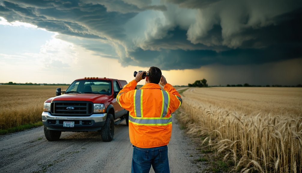
Recognition of severe weather features builds directly upon your comprehension of thunderstorm dynamics and atmospheric processes. You’ll identify storm feature characteristics through distinct visual cues: wall clouds exhibiting persistent rotation, inflow tails extending toward the rain-free base, and condensation funnels descending from rotating cloud bases.
Severe weather indicators include hailstones exceeding one inch diameter, greenish sky tints, and straight-line winds surpassing 58 mph. Monitor for debris clouds moving horizontally, indicating damaging downbursts, and observe pressure jumps preceding sudden wind shifts that signal rear-flank downdrafts. Cloud-to-ground lightning within six miles demands immediate shelter.
You’ll distinguish tornado damage from straight-line wind patterns by examining tree snap points versus uprooting patterns. Laminar wall cloud surfaces suggest organized mesocyclone development, while rapid dust ascent confirms tornado touchdown.
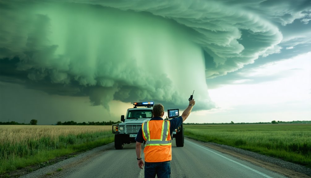
Reporting Methods and Safety
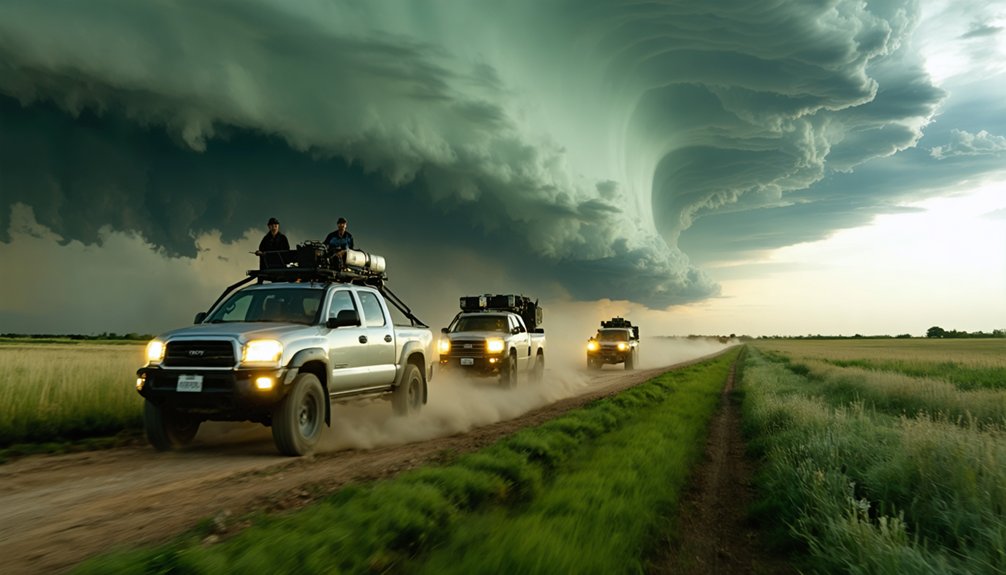
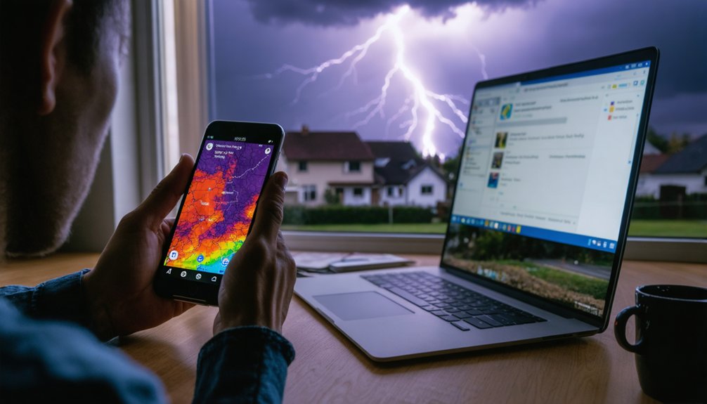
Effective communication channels between storm spotters and the National Weather Service constitute the critical link that transforms field observations into actionable tornado warnings. Your reporting autonomy demands multiple backup methods: phone calls for immediate tornado threats, SpotterNetwork.org for automated GPS tracking, and amateur radio networks when cellular systems fail. Communication continuity planning guarantees you’ll reach forecasters regardless of infrastructure damage.
Your reports must include precise data:
Mobile spotter positioning in high-visibility areas maximizes observation capability while maintaining your safety perimeter. Never compromise personal security for documentation—your survival enables continued reporting throughout the event’s duration.
Recognizing Visual Cues That Signal Tornado Development
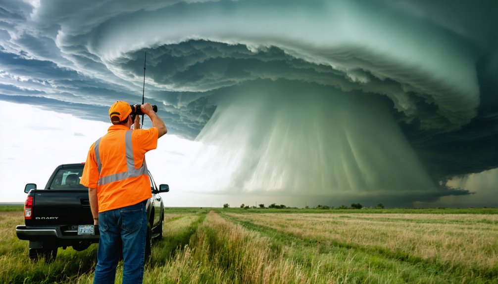
When observing a supercell thunderstorm, storm spotters must rapidly assess multiple atmospheric features that signal tornado genesis. Low cloud bases with sharp, cauliflower-defined updraft towers represent critical storm intensification indicators.
You’ll recognize increasing tornado potential through visual identification techniques including horseshoe or circular updraft bases, rising scud material indicating active convergence, and well-defined wall clouds exhibiting visible rotation. The RFD clear slot wrapping around the wall cloud elevates threat to imminent.
Watch for ground-level dust whirls preceding funnel touchdown, multiple sub-vortices within larger circulations, and horizontal vortices suggesting violent tornadoes. Power flashes provide blue-green confirmation of damaging winds. Your independent assessment of these features enables autonomous decision-making that protects communities while maintaining situational awareness without bureaucratic delay.
The Reporting Chain: From Spotter to National Weather Service
When you observe tornado indicators, your report must traverse an organized communication infrastructure to reach NWS meteorologists making warning decisions.
Net Control Stations serve as central aggregation points where amateur radio operators coordinate multiple spotter observations, eliminating duplicate reports and standardizing critical information including precise location coordinates, time stamps, and phenomenon descriptions.
This consolidated transmission process guarantees NWS receives verified, non-redundant data through established protocols—typically amateur radio frequencies or direct phone lines—enabling meteorologists to integrate your ground truth observations with radar signatures within seconds of your initial report.
Net Control Station Function
During severe weather activations, the Net Control Station (NCS) functions as the critical coordination hub between field spotters and National Weather Service forecasters. You’ll find NCS operators managing directed nets with strict discipline, filtering hundreds of reports into actionable intelligence. Through net control workload management, they prevent information overload by implementing hub-and-sub-net architectures that reduce communication spans from 500+ spotters to 3-10 key contacts.
Resource coordination optimization employs these essential structures:
Your NCS designates backup channels, relays updated warnings to sub-nets, and coordinates post-event damage assessments—ensuring forecasters receive verified data without communication bottlenecks that compromise warning accuracy.
Amateur Radio Network Coordination
As severe weather develops across your operational area, amateur radio networks implement a hierarchical reporting chain that channels spotter observations through designated coordination points to National Weather Service forecast offices.
You’ll operate within a structured frequency allocation system where Net Control Station manages communication flow during activation conditions GREEN, YELLOW, and RED.
During Condition RED tornado warnings, frequency control becomes absolute—you maintain radio silence unless reporting tornadoes, funnel clouds, or wall clouds.
Resource management centers on one designated liaison transmitting verified reports directly to NWS while Net Control coordinates field observers.
This decentralized yet coordinated approach enables you to provide ground truth data that supplements radar limitations, ensuring meteorologists receive real-time intelligence for warning decisions without compromising operational efficiency or communication clarity.
Consolidated Report Transmission Process
The transmission chain operates through three critical stages:
Each relay point introduces potential error; however, organized networks maintain accuracy through standardized reporting procedures, enabling you to contribute directly to life-saving warning operations.
How Spotter Reports Enhance Doppler Radar Technology
Despite its sophisticated capabilities, Doppler radar technology faces inherent limitations that storm spotters directly address through ground-level observations. Radar scans require 4.5 minutes per cycle in precipitation mode, creating temporal gaps where rapidly evolving mesocyclones (2-6 miles diameter) can develop undetected rotation. You’ll find spotters fill critical blind spots by validating wall clouds, funnel formations, and actual tornado touchdowns—phenomena radar algorithms can’t autonomously confirm.
Your ground truth reports enable meteorologists to calibrate velocity data showing motion toward or away from radar installations, improving radar data interpretation when paired with visual confirmation of persistent rotation. This synergy proves essential for enhancing situational awareness during warning issuance.
Dual-Doppler systems stationed 40 miles apart benefit substantially from your real-time positioning data, while phased array radar‘s sub-one-minute scans gain actionable context through immediate spotter validation of storm-scale features.
The Integrated Warning Team Approach
When severe weather threatens populated areas, coordinated response mechanisms between forecasters, emergency personnel, and communication networks determine warning effectiveness more than any single technology. The Integrated Warning Team unites NWS meteorologists, emergency managers, broadcast media, and amateur radio networks through coordinated communication strategies that eliminate conflicting messages during critical moments.
Coordinated communication between meteorologists, emergency managers, and media networks proves more critical to warning effectiveness than any individual technology system.
Tabletop exercises simulate real-world scenarios using authentic severe weather data:
Multi agency collaboration goals focus on extending tornado warning lead times to 30-60 minutes through Warn-on-Forecast integration. Post-event analyses confirm this partnership model produces superior public response compared to isolated organizational efforts.
Public Safety Impact of Accurate Storm Reports
Accurate storm reports from trained spotters directly influence survival outcomes during tornado events by reducing the gap between detection and public notification. When spotters confirm tornado formations, meteorologists issue warnings with greater confidence, achieving probability of detection rates that enhance public preparedness and response.
However, effectiveness depends on civilian comprehension—only 11% of mid-south residents properly identify warnings as confirmed tornado sightings or radar indications, while 50% can’t define them at all. This knowledge deficit undermines effective communication strategies essential for protective action.
Geographic factors and prior tornado experience improve preparedness, particularly among rural populations who’ve faced previous threats. You’re empowered to understand these distinctions: watches indicate potential conditions, while warnings demand immediate shelter decisions based on confirmed danger requiring autonomous, informed response.
Filling Critical Gaps in Weather Observation Systems
While Doppler radar systems excel at detecting mid-atmosphere rotation and precipitation patterns, they can’t observe critical ground-level phenomena that determine actual tornado touchdowns and storm impacts. You’re witnessing technology’s fundamental limitation: radar beams overshoot low-altitude features essential for municipal emergency planning and public risk perception.
Radar beams overshoot ground-level tornado touchdowns—the critical observations that determine actual storm impacts and community risk.
SKYWARN’s 350,000-400,000 trained volunteers address these observation deficiencies through direct field reporting:
Your spotter network integrates seamlessly with 160 NWS radars, filling data voids that affect 50,000 annual warnings. This ground-based intelligence transforms radar-detected rotation into actionable tornado confirmation, enabling your community’s independent response decisions.
Frequently Asked Questions
What Equipment Do Storm Spotters Need to Purchase for Reporting?
You’ll need handheld radios and mobile weather apps at bare minimum. Don’t put all your eggs in one basket—backup anemometers, lightning detectors, and satellite communicators guarantee you’re maintaining operational redundancy when cellular networks fail during severe convective events.
How Long Does SKYWARN Training Take to Complete?
Storm spotter certification through SKYWARN training takes approximately 90-120 minutes to complete. You’ll gain essential storm spotter qualifications during this single session, covering severe weather identification, safety protocols, and communication procedures. Retraining’s recommended every 2-4 years to maintain current skills.
Can Storm Spotters Claim Volunteer Hours for Tax Deductions?
You can’t deduct volunteer hours, but you’re entitled to claim unreimbursed out-of-pocket costs. Tax deductions for training costs and reimbursement for equipment expenses require itemization on Schedule A with documented proof from qualified 501(c)(3) organizations.
Do Spotters Receive Compensation for Fuel and Travel Expenses?
You won’t receive reimbursement policies covering fuel cost estimates as a SKYWARN spotter. The program operates entirely on volunteer contributions without financial compensation, allowing you freedom to serve communities through independent severe weather observation and reporting.
What Insurance Coverage Exists if Spotters Are Injured While Observing?
You’ll need specialized personal accident insurance and liability coverage since standard policies exclude storm chasing. Adventure sports policies cover medical expenses, equipment damage, and trauma injuries from vehicle overturns or wind-projected debris during severe weather observation activities.