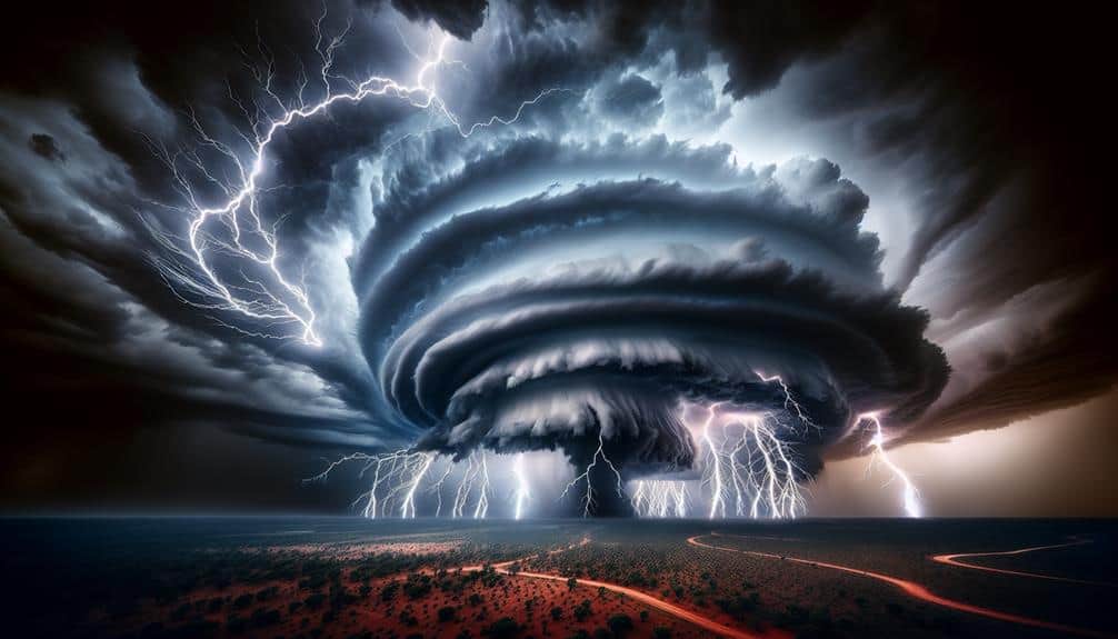
We identify these top supercell storm chasing destinations because they offer prime meteorological conditions and advanced tracking capabilities. Tornado Alley and the Great Plains are ideal due to efficient air mass convergence and annual averages of 1,200 tornadoes. The Texas Panhandle and Kansas Prairie boast unobstructed views and real-time data collection with mobile mesonets. Oklahoma's terrain and South Dakota's rolling plains provide strategic positions for Doppler radar tracking. Australia's Tornado Corridor offers unique conditions for supercell formation, requiring rigorous safety. These factors make these locations hotspots for data-driven storm chasing and we can explore how each site contributes further.
Key Points
- Prime locations for observing supercell formation due to ideal atmospheric conditions.
- High frequency of tornado occurrences provides ample research opportunities.
- Open landscapes offer unobstructed views and accurate storm tracking.
- Advanced tools and real-time data enhance safety and effectiveness of storm chasing.
Tornado Alley, USA
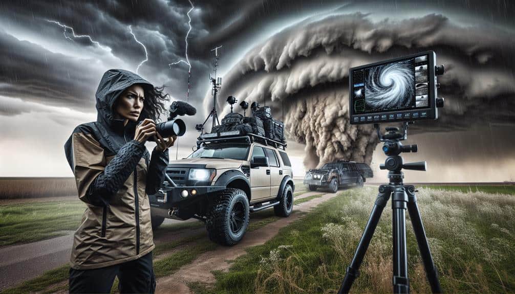
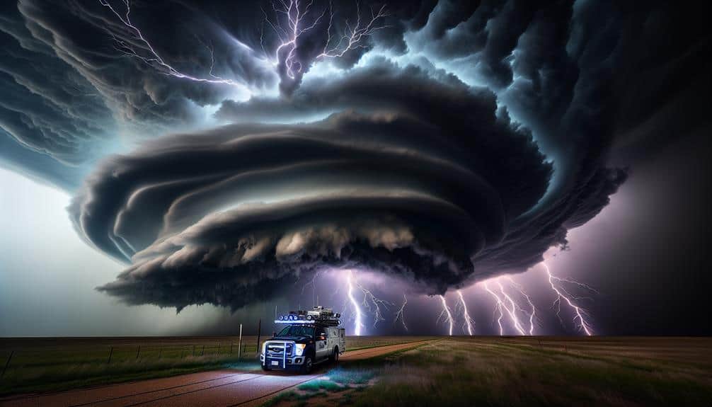
Tornado Alley, USA, presents a prime location for supercell storm chasing due to its high frequency of severe thunderstorms and tornado occurrences, particularly from late spring to early summer. We employ advanced storm chasing techniques, such as radar interpretation and GPS tracking, to follow these violent weather systems. Utilizing mobile mesonets and Doppler on Wheels (DOW), we gather real-time data, which is essential for understanding storm dynamics. However, our commitment to safety precautions is paramount. We always maintain a safe distance, ensuring we've multiple escape routes and constantly monitor changes in storm behavior.
The impact on local communities can be profound. Tornadoes in Tornado Alley often lead to significant property damage, economic loss, and, unfortunately, sometimes loss of life. As a result, our role extends beyond chasing; we also contribute to disaster preparedness. By providing accurate and timely information, we help local authorities issue warnings and conduct evacuations. Our efforts aid in the development of better building codes and emergency response strategies, ultimately enhancing community resilience.
To conclude, our analytical approach in Tornado Alley not only fuels our passion for freedom and adventure but also plays a pivotal role in safeguarding those who live in these high-risk areas.
Great Plains, USA
Located in the heart of the United States, the Great Plains offer a fertile ground for supercell storm chasing due to their ideal atmospheric conditions and expansive terrain. The flatlands, extending from the Canadian border to Texas, provide unobstructed views essential for storm photography. We can observe the development of extreme weather systems, particularly supercells, which thrive in this region due to the convergence of warm, moist air from the Gulf of Mexico and cool, dry air from the Rockies.
We find that the Great Plains are a hotspot for Midwest storms, often resulting in severe weather phenomena such as large hail, damaging winds, and tornadoes. This region's vast openness allows storm chasing tours to track these systems efficiently, minimizing visibility issues and maximizing safety. Data indicates that the Great Plains experience an average of 1,200 tornadoes annually, with peak activity from April to June.
For those seeking the freedom to capture nature's raw power, the Great Plains provide an unparalleled experience. The combination of atmospheric dynamics and geographical features makes this region a prime destination for both amateur and professional storm chasers. Here, we can truly appreciate the complexity and beauty of extreme weather.
Texas Panhandle
The Texas Panhandle stands as a crucial hub within Tornado Alley, with a high frequency of supercell activity verified by NOAA data.
We should focus on the best viewing spots, particularly around Amarillo, where visibility is enhanced by the region's flat terrain.
Analyzing seasonal weather patterns, we observe peak storm activity between April and June, supported by climatological statistics.
Tornado Alley Hub
As storm chasers, we recognize the Texas Panhandle as a prime location for observing supercell storms due to its unique meteorological conditions and high frequency of severe weather events. The region's flat terrain, combined with the convergence of moist Gulf air and dry desert winds, creates an ideal environment for supercell formation. This intersection of air masses often leads to the development of tornadoes, making it a cornerstone of our storm chasing culture.
Safety precautions are paramount when exploring the volatile weather patterns here. We equip our vehicles with the latest radar technology, GPS systems, and communication tools to stay informed and connected. Our priority is to capture storm photography that not only showcases the raw power of nature but also provides valuable data for meteorological research. The adrenaline rush we experience during these pursuits is unparalleled, driving our passion for this intense pursuit.
Data from the National Weather Service indicates that the Texas Panhandle experiences an average of 43 tornadoes per year. This high frequency underscores the importance of meticulous planning and real-time analysis. By adopting stringent safety measures and leveraging advanced forecasting tools, we maximize our opportunities while minimizing risks.
Optimal Viewing Spots
Why do we consider Amarillo, Texas, a prime vantage point for observing supercell storms in the Texas Panhandle?
The answer lies in its unique geographical attributes and climatic conditions. Amarillo is positioned at the intersection of various atmospheric currents, making it a hotspot for supercell formation. The wide-open plains provide unobstructed views, necessary for effective storm watching.
When preparing for a storm-watching expedition in the Texas Panhandle, let's prioritize safety and gear.
Best safety tips include maintaining a safe distance from the storm and always having an escape route planned. High-quality GPS devices and real-time weather apps are essential. We should also equip ourselves with the finest gear: a reliable 4×4 vehicle, weather radios, and high-resolution cameras. Anemometers and barometers are crucial for data collection.
Preparation advice emphasizes checking local weather forecasts and updates from the National Weather Service. Also, pack emergency supplies—water, food, first aid kits, and extra fuel. Amarillo's strategic location allows for quick adjustments based on storm movement, providing flexibility and freedom necessary for storm chasers.
This meticulous preparation and prime location make Amarillo a top destination for those seeking the thrill of supercell observation.
Seasonal Weather Patterns
Understanding the seasonal weather patterns in the Texas Panhandle is essential for predicting supercell activity and planning successful storm-chasing missions. This region's unique geographical features and climatic conditions make it a hotspot for supercell formation, especially during the spring and early summer months.
Key factors influencing supercell development include:
- El Niño impact and global climate: El Niño events can substantially alter atmospheric conditions, leading to increased moisture and instability in the Texas Panhandle. These changes often enhance the probability of supercell formation. By monitoring global climate patterns, we can better forecast supercell activity.
- Hurricane season and tropical regions: While hurricanes primarily impact coastal areas, remnants of tropical systems can travel inland and interact with the local weather in the Panhandle. This interaction can provide the necessary moisture and lift, creating a conducive environment for supercells.
- Seasonal temperature gradients: The sharp temperature contrasts between the cold, dry air from the Rockies and the warm, moist air from the Gulf of Mexico create the perfect conditions for severe weather. Understanding these gradients helps us pinpoint likely supercell development zones.
Kansas Prairie
In Kansas Prairie, we encounter vast open landscapes that provide unobstructed views essential for tracking storm development.
According to NOAA data, Kansas averages over 90 tornadoes annually, making it a significant hotspot for supercell activity.
Vast Open Landscapes
The Kansas Prairie offers vast open landscapes that provide unobstructed views essential for analyzing supercell storm development and movement. When we venture into this remote wilderness, the expansive horizons support our storm chasing endeavors by allowing us to monitor storm structures and trajectories with precision. This clarity is essential for data collection and safety, enhancing our overall storm chasing opportunities.
These open landscapes offer several key advantages:
- Visibility: The unobstructed views allow us to see storm formations from miles away, which is crucial for tracking storm evolution and making real-time decisions.
- Accessibility: The terrain, primarily consisting of flatlands and minimal tree coverage, enables us to navigate freely and reach optimal vantage points without hindrance.
- Data Accuracy: With fewer obstructions, instruments like anemometers and Doppler radar can operate with higher accuracy, providing reliable data on wind speeds and storm dynamics.
Frequent Tornado Occurrences
Kansas Prairie frequently experiences tornado occurrences, providing storm chasers with ample opportunities to study these powerful weather phenomena. The region's unique combination of flat terrain and atmospheric conditions makes it a prime location for observing tornado formation and supercell dynamics. Data from the National Weather Service indicate that Kansas averages over 90 tornadoes annually, highlighting its significance in tornado research.
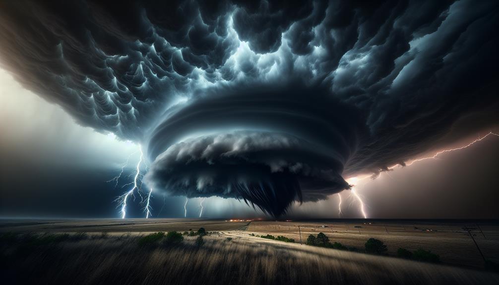
Our storm chasing tactics often begin with analyzing weather models to predict supercell development. Supercells are the precursors to most significant tornadoes, characterized by a rotating updraft known as a mesocyclone. Understanding these dynamics allows us to position ourselves strategically, maximizing observation while ensuring tornado safety.
We employ mobile Doppler radar and GPS mapping to track storm cells in real-time. This technology enhances our ability to monitor changes in wind speed and direction, which are critical in identifying potential tornado formation. By studying these elements, we gain insights into the lifecycle of tornadoes and the conditions that favor their development.
Kansas Prairie's frequent tornado occurrences not only provide a natural laboratory for scientific inquiry but also empower us with the freedom to explore and understand the raw power of nature.
Oklahoma's Tornado Territory
Oklahoma's Tornado Territory offers storm chasers a prime location, with data showing an average of 56 tornadoes annually. This frequency makes it an ideal spot for those of us looking to capture the raw power of nature through storm photography.
To maximize our storm-chasing experience, we must balance our enthusiasm with tornado safety protocols.
When we venture into Oklahoma, we should be aware of the following key factors:
- Geographical Hotspots: The region's flat terrain and central location in Tornado Alley amplify supercell formation, making areas like Moore and Norman frequent targets.
- Meteorological Data: Access to real-time Doppler radar and NOAA weather updates is essential. These tools provide us with the situational awareness necessary to stay safe while capturing high-quality footage.
- Safety Precautions: Vital equipment includes GPS navigation systems, weather radios, and emergency kits. Familiarizing ourselves with local roads and shelters can be lifesaving.
South Dakota's Storm Zone
While Oklahoma offers a high frequency of tornadoes, South Dakota's Storm Zone presents a unique blend of supercells and mesoscale convective systems that challenge our predictive capabilities and enhance our storm-chasing pursuits. This region's complex meteorological dynamics create fertile ground for extreme weather phenomena, providing us with unparalleled storm chasing opportunities.
By analyzing historical data, we observe that South Dakota's peak storm season typically spans from late spring to early summer. The interaction between the Gulf moisture and the dryline boundary sets the stage for severe thunderstorms capable of producing large hail, damaging winds, and tornadoes. The mesoscale convective systems, often forming in the late afternoon and evening, offer a dynamic environment for studying storm evolution and behavior.
In terms of storm-chasing logistics, South Dakota's relatively sparse population density and expansive road network facilitate unobstructed tracking of storm cells. The terrain, primarily consisting of rolling plains, allows us clear visual access to developing weather systems, enhancing our ability to document and analyze storm structure.
Ultimately, South Dakota's Storm Zone not only expands our understanding of extreme weather but also provides a thrilling and scientifically rich backdrop for our storm-chasing endeavors.
Australia's Tornado Corridor
Australia's Tornado Corridor, though less renowned than its American counterparts, consistently presents intriguing opportunities for studying rare and intense tornadic activity and associated weather patterns. This region, spanning parts of Queensland and New South Wales, offers unique challenges and rewards for enthusiasts of storm chasing and extreme weather phenomena.
In Australia's Tornado Corridor, we can expect:
- Diverse Meteorological Conditions: The interaction between tropical moisture from the north and cold fronts from the south creates a volatile environment conducive to supercell formation.
- Safety Precautions: The region's remote nature necessitates rigorous planning and adherence to safety measures. Limited infrastructure means we must be self-sufficient, carrying extra fuel, food, and communication tools.
- Photography Opportunities: The open landscape, with minimal light pollution, provides unparalleled opportunities for capturing dramatic storm structures and lightning displays.
Engaging in storm chasing here requires an analytical approach. We rely on data from meteorological models and satellite imagery to predict supercell development accurately. Additionally, the sparse population density allows for safer tracking of storms, reducing the risk to human life and property.
Such conditions make Australia's Tornado Corridor not only an exciting destination for storm chasers but also a critical area for advancing our understanding of extreme weather patterns.
Frequently Asked Questions
What Equipment Is Essential for Storm Chasing?
For storm chasing, we need dependable camera gear for documentation, communication devices for coordination, and effective vehicle maintenance. Emergency supplies are essential for safety. This equipment guarantees we capture data while maintaining freedom and safety on the road.
How Do Meteorologists Predict Supercell Storms?
Imagine towering storm clouds; we employ predictive models to analyze atmospheric conditions, track storm formation, and predict supercell storms accurately. Our data-driven, analytical approach guarantees we're always a step ahead, embracing the freedom of discovery.
What Safety Precautions Should Storm Chasers Take?
When storm chasing, we should guarantee access to emergency shelters, maintain constant communication, and use weather radios and GPS trackers. This approach maximizes safety by providing real-time updates and accurate positioning during volatile weather conditions.
How Do Supercell Storms Differ From Other Storm Types?
Supercell storms differ from other storm types due to their unique storm dynamics, wind patterns, cloud formations, and lightning patterns. They possess a rotating updraft called a mesocyclone, leading to more severe weather phenomena and tornado potential.
Can Storm Chasing Be Done Year-Round?
Can storm chasing be done year-round? It depends. By analyzing seasonal patterns and exploring international destinations, we discover that certain regions offer prime opportunities throughout the year, allowing us the freedom to chase storms beyond typical seasons.