You’ll need RadarScope for Level II NEXRAD data streams showing mesocyclone signatures and velocity couplets, while Storm Radar delivers 72-hour future radar and 120-minute nowcasting for intercept positioning. MyRadar’s fast-loading interface with CarPlay integration keeps you tracking during high-speed repositioning, and Storm by Weather Underground provides microclimate-level precision through 250,000+ personal weather stations. Each app offers specialized tracking parameters—from debris ball detection to hail algorithms—that transform raw meteorological data into actionable chase decisions the moment systems develop.
Key Takeaways
- RadarScope delivers professional-grade Level II NEXRAD data with mesocyclone signatures, velocity couplets, and dual-polarization for precise tornado debris detection.
- Storm Radar provides 72-hour future radar and 30 specialized tracking parameters for strategic route planning and storm intercept positioning.
- MyRadar offers instant-loading animated radar with CarPlay integration, ensuring continuous awareness during high-speed chaser repositioning maneuvers.
- Storm by Weather Underground combines 250,000+ personal weather stations with GOES-16 satellite imagery for microclimate-level precision and ground-truth verification.
- Essential storm apps feature real-time rotation detection, configurable tornado warnings, and 120-minute nowcasting algorithms for accurate storm path projection.
Essential Features Storm Chasers Need in Tracking Apps
When lives hang in the balance during severe weather events, storm chasers can’t afford tracking apps with subpar data resolution or delayed updates. You need NEXRAD Level 3 super-resolution data displaying at 250m accuracy, not degraded consumer feeds. Critical capabilities include real-time rotation detection, hail size algorithms, and lightning strike networks—not basic precipitation overlays.
Your app must offer storm mode customization: configurable push notifications for tornado warnings, velocity couplets, and mesocyclone signatures within your pursuit radius. Hyper local crowdsourcing from 250,000+ personal weather stations provides ground-truth verification that satellite data can’t match.
Equally crucial: 120-minute nowcasting algorithms that project storm paths, letting you position safely ahead of developing supercells. Without precise future radar and customizable severe-weather parameters, you’re chasing blind.
Storm Radar: AI-Powered Visualization for Active Pursuit
Because milliseconds matter when intercepting rotating storms, Storm Radar’s AI Weather Assistant functions as your onboard meteorologist, delivering pattern-recognition insights that raw data feeds can’t provide. You’ll access animated weather pattern insights through high-resolution single-site radar, tracking velocity signatures and mesocyclonic rotation in real-time.
The platform’s visualization tools give you tactical advantages:
- 72-hour future radar (US coverage) for route planning and intercept positioning
- Precision storm proximity alerts with lightning detection for your exact coordinates
- Advanced overlays including wind speed, hail probability, and tropical track projections
Storm Tracks feature offers 30 specialized tracking parameters, monitoring intensity and motion vectors. Premium access grants professional-grade radar resolution and advanced map layers—essential equipment for autonomous pursuit operations where split-second decisions determine successful intercepts.
Storm by Weather Underground: Ultra-High Resolution Monitoring
Weather Underground’s Storm app delivers microclimate-level precision through its network of 250,000+ personal weather stations—a data density that transforms hyperlocal forecasting from approximation into tactical intelligence. You’ll access GOES-16 satellite imagery updated every 15 minutes, alongside Nexrad radar displaying real-time lightning strikes and storm vectors with probability corridors.
The platform integrates thirteen data display configurations across ten map overlays, allowing simultaneous tracking of wind velocity fields, barometric pressure gradients, and precipitation accumulation. Customizable weather alerts trigger for your exact GPS coordinates—not the nearest airport 30 miles away.
Real-time webcam networks provide visual confirmation of developing systems, while doppler radar layers expose rotation signatures and hail cores. Available free on iOS and Android, it’s hyperlocal weather reports engineered for autonomous decision-making in dynamic atmospheric conditions.
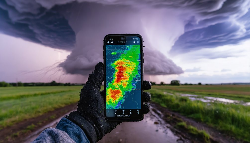
RadarScope: Professional-Grade Data Analysis Tools
RadarScope processes Level II radar data streams directly from NEXRAD installations, delivering the same raw meteorological intelligence that National Weather Service forecasters analyze in operations centers. You’ll access native radial format displays revealing mesocyclone signatures, velocity couplets, and debris balls with 2-10 minute updates matching actual scanning strategies.
The platform’s data integration extends beyond basic reflectivity:
- Dual-polarization radar identifies precipitation types and tornado debris signatures
- Storm relative velocity depicts wind motion with color-coded directional indicators
- Derived contours quantify hail probability, size, and azimuthal shear through custom algorithms
Pro tiers unveil atmospheric soundings, MRMS products, and lightning feeds with both cloud-to-ground and cloud-to-cloud detection. Severe weather notifications include NWS storm tracks with TVS attributes, SPC outlooks, and customizable alerts for specific intensity thresholds.
MyRadar: Speed and Simplicity for Mobile Chasers
When you’re positioning for rapidly evolving storm systems, MyRadar’s fast-loading animated radar interface delivers critical precipitation data within seconds of launch. The app’s storm motion animation overlays enable you to visualize mesocyclone movement and precipitation trajectories without manual interpretation of raw velocity data.
Through CarPlay integration, you’ll maintain continuous radar awareness during high-speed repositioning, with hands-free access to real-time HD Doppler imagery and National Weather Service alerts.
Rapid Radar Load Times
For storm chasers who need immediate situational awareness while traversing rapidly evolving weather systems, MyRadar’s load speed represents a critical operational advantage. You’ll experience instant radar interaction the moment you launch the app—your location appears with animated weather overlay automatically. This guarantees the waiting periods that compromise chase decisions during time-sensitive intercepts are avoided.
The app’s architecture prioritizes on-demand weather insights through optimized high-definition radar technology:
- Hi-definition animated radar displays precipitation movement immediately upon startup
- Seamless nationwide composite mosaic loads without lag between radar station boundaries
- Patent-pending hyper-local rainfall prediction delivers hour-by-hour forecasts rapidly
You’re not constrained by sluggish interfaces when storm cells evolve quickly. MyRadar’s performance confirms you maintain mobility advantage, accessing critical meteorological data precisely when conditions demand immediate action.
Storm Motion Animation
MyRadar’s animated radar visualization transforms static precipitation data into continuous motion sequences that reveal storm trajectory, intensification patterns, and mesoscale circulation features essential for intercept positioning. You’ll access seamless NEXRAD mosaics displaying precipitation rate, hourly accumulation, and storm totals through continuous playback. The platform’s storm motion advancements include hybrid hydrometeor classification animations and vertically integrated liquid displays that track convective evolution in real-time.
Enhanced echo tops animate dynamically, revealing updraft strength fluctuations critical for severe weather assessment. Data driven radar dynamics deliver hour-by-hour precipitation models with hyper-local rainfall predictions, enabling rapid trajectory forecasting. The centered play button functions as your motion control portal, while toggleable layers overlay surface winds and jetstream patterns directly onto animated radar sequences for all-encompassing chase planning.
CarPlay for Vehicle Chasing
- Dual-pane radar/satellite modes for simultaneous surface and atmospheric analysis
- Hour-by-hour precipitation models informing intercept geometry calculations
- Hurricane tracking with National Hurricane Center cone probabilities
Alexa voice commands (“load my radar”) further streamline hands-free operation, while customizable tornado and severe weather alerts maintain situational awareness without manual app checks during high-speed pursuit phases.
Accuweather: Precision Timing With Minutecast Technology
When storm chasers need precipitation forecasts down to the exact minute, AccuWeather’s patented MinuteCast technology delivers hyper-localized data for any street address or GPS location. You’ll access minute-by-minute forecasts spanning 120 minutes, expandable to four hours, covering rain, snow, ice, mixed precipitation, and hail with precise start and end times.
The hyperlocal precision extends across 210 countries, displaying intensity through color-coded bars that match radar imagery. You can integrate MinuteCast Along A Route with navigation systems for dynamic chase planning, while customizable integrations allow data output to smartwatches and connected vehicles.
The free iOS and Android apps position MinuteCast front-and-center with scrollable interfaces and list views. This technology gives you the temporal precision necessary for strategic positioning during rapidly evolving storm systems.
Clime NOAA Weather Radar: Comprehensive Meteorological Intelligence
Clime NOAA Weather Radar delivers storm chasers three critical capabilities for real-time meteorological assessment. You’ll access animated radar loops displaying 40 minutes of precipitation movement, track hurricane positions with projected path analysis, and monitor National Weather Service warnings through interactive polygon mapping across 25+ countries.
The platform consolidates governmental weather data with lightning strike detection, wildfire tracking, and minute-by-minute precipitation forecasting through its RainScope feature.
Live Storm Visualization Tools
Several advanced storm tracking applications provide meteorological intelligence, but Clime NOAA Weather Radar distinguishes itself through direct integration of high-resolution NEXRAD data streams. You’ll access Level II and Level III radar products updating every 10-15 minutes, enabling real time storm visualization with velocity scans and dual-polarization analysis.
The platform combines GOES satellite imagery with numerical weather prediction models, delivering precision through 90-meter resolution equivalents.
Your hazardous weather alerts cover:
- Tornado warnings with rotation detection
- Flash flood notifications from precipitation accumulation data
- Severe thunderstorm tracking via reflectivity analysis
You’ll utilize 3D radar rendering and customizable Doppler overlays for tactical positioning. The interface exports data in GeoTIFF, KMZ, and Shapefile formats, supporting mobile content creation without restrictive paywalls limiting your operational flexibility during active chase scenarios.
Hurricane Tracking and Projections
Beyond localized severe weather events, tropical cyclone systems demand specialized monitoring capabilities that extend across maritime and coastal regions. Clime’s hurricane tracker delivers real-time positioning data and hurricane path projection through interactive mapping interfaces powered by NOAA radar systems.
You’ll access National Weather Service polygons displaying watches and warnings across US territories, Puerto Rico, and Hawaii—critical coverage for hurricane-prone zones.
The platform’s customized alert delivery system enables push notifications for bookmarked coastal locations, transmitting storm strength updates and trajectory modifications as they develop. Premium subscribers gain access to extensive tropical storm monitoring across all saved positions, complemented by 72-hour precipitation forecasts that reveal anticipated rainfall patterns along projected hurricane corridors.
Animated wind maps provide intensity assessment data, while minute-by-minute RainScope technology tracks localized impacts during active hurricane events.
Official Meteorological Data Aggregation
While storm chasers often juggle multiple data sources during active weather events, Clime consolidates NOAA radar feeds into a unified intelligence platform that eliminates fragmented monitoring workflows. You’ll access official National Weather Service data through high-resolution radar imagery updated in real-time, ensuring real time data integrity during critical chase situations.
The system provides animated loops spanning 40 minutes of precipitation history, while automated alerts monitoring delivers tornado warnings, hurricane notifications, and severe weather polygons directly to your device.
Core meteorological capabilities include:
- Precipitation forecasting extending 72 hours (premium) with hourly granularity across 14-day periods
- Multi-layer atmospheric visualization: satellite cloud coverage, temperature distributions, wind vectors, lightning strike detection
- Extensive environmental monitoring: air quality indices, wildfire perimeters, barometric pressure gradients
This consolidation allows you to maintain situational awareness without switching between disparate data platforms during intercepts.
Frequently Asked Questions
Can Storm Tracking Apps Work Offline in Areas With Poor Connectivity?
Most storm tracking apps can’t provide reliable offline coverage since they require constant connectivity for up-to-date radar imagery. Only Windy.app offers true offline functionality—you’ll need to pre-download map data before losing signal to maintain access.
Which Apps Offer the Best Battery Optimization for Extended Storm Chasing?
MyRadar and Clime excel at battery optimization, with MyRadar users reporting 40% less drain. You’ll appreciate their lightweight design, battery life indicators, and efficient camera integration that won’t chain you to chargers during critical chase moments in remote areas.
Are There Subscription Costs for Multiple Devices on the Same Account?
Most apps don’t charge per-device fees. RadarOmega’s device pricing plans let you access subscriptions cross-platform with one account. WeatherWise and Perry Weather offer multi-device account options without additional costs, maximizing your tracking freedom.
How Accurate Are Tornado Prediction Algorithms Compared to Traditional Methods?
AI tornado prediction algorithms now exceed traditional methods, achieving 85%+ tornado warning accuracy for severe tornadoes versus 70%+ false alarms historically. You’ll benefit from real time data visualization that enables faster, more reliable threat assessment during active storm chasing operations.
Do Any Apps Integrate With External Weather Station Equipment?
Yes, you’ll find several apps offer external weather station integration for enhanced monitoring. WeatherLink, Tempest Weather App, and Weather Underground provide real time weather data aggregation from personal stations, giving you independent hyperlocal conditions without relying solely on government networks.


