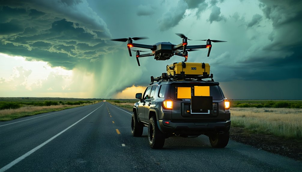
For storm chasing, you’ll want drones built around wind resistance, payload capacity, and flight endurance. The DJI M30 delivers 41 minutes of flight time and withstands harsh weather, while fixed-wing platforms outperform quadcopters in violent, turbulent conditions by converting airflow into lift. The TORUS Project validated both approaches through multi-asset data collection spanning temperature, pressure, and wind speed measurements. Your ideal platform depends on whether you’re running a research fleet, broadcast rig, or solo intercept mission — and each setup has its own critical gear requirements.
Key Takeaways
- The DJI M30 excels in storm chasing with 41-minute flight time, harsh weather resilience, and dock-based autonomous deployment up to 4.3 miles.
- The Mavic 3 Pro’s triple-camera system delivers broadcast-quality footage, making it ideal for capturing high-fidelity storm dynamics in real time.
- Fixed-wing drones outperform rotary-wing models in violent storms by converting turbulent airflow into lift and maintaining continuous forward momentum.
- For research fleets, fixed-wing drones with in-situ sensor payloads best capture temperature, pressure, humidity, and wind speed data during storms.
- Solo chasers benefit most from the M30’s compact design, autonomous dock capability, and versatile equipment adaptability for efficient storm monitoring.
Wind Resistance, Payload, and Flight Time: Storm Chasing Drone Specs That Matter
When you’re selecting a drone for storm chasing, three specs separate viable platforms from expensive wreckage: wind resistance, payload capacity, and flight time.
Three specs determine whether your drone survives storm chasing — or becomes expensive debris scattered across a field.
You need weather resilience engineered into the airframe, not patched on afterward. The DJI M30 Enterprise delivers 41-minute flight endurance and operates through rain, snow, and ice — giving you real mission planning flexibility during fast-moving storm tracking operations.
Payload capacity determines what sensors you’re carrying, directly affecting data transmission quality and situational awareness. Camera stabilization becomes non-negotiable when you’re capturing high-contrast, high-motion environments.
Fixed-wing platforms handle gusty conditions better than multi-rotors, making them preferable for violent supercell penetration.
Know your specs before launch — because storms don’t wait for underpowered hardware to catch up.
DJI M30 vs. Mavic 3 Pro for Storm Monitoring
Choosing between the DJI M30 Enterprise and the Mavic 3 Pro comes down to mission profile: one’s built for endurance and resilience, the other for imaging precision.
The DJI M30 advantages are clear when your storm monitoring strategies demand durability—it flies 41 minutes, withstands rain, snow, and ice, and supports autonomous dock-based deployment up to 4.3 miles out.
You’re not babysitting it between squalls.
Mavic 3 limitations emerge in extreme environments, but its triple-camera system and global shutter integration make it irreplaceable for capturing broadcast-quality storm dynamics at safe distances.
Smart drone deployment tactics mean running both platforms together—M30 handles persistent field coverage while the Mavic 3 Pro locks in high-fidelity visual data.
You’re not choosing one; you’re building a system.
Why Fixed-Wing Drones Handle Violent Storms Better Than Quadcopters
Fixed-wing drones outperform quadcopters in violent storm environments because their aerodynamic design converts gusty, turbulent airflow into lift rather than fighting it.
Their fixed wing advantages stem from continuous forward momentum, which maintains stability when erratic wind shear would flip or destabilize a multi-rotor platform.
You’ll notice storm resilience is built into fixed-wing architecture at a structural level.
The TORUS project deployed three fixed-wing unmanned aircraft systems across Central Plains supercells in 2019, successfully measuring temperature, pressure, humidity, and wind speeds inside active storm cells — data collection quadcopters simply can’t replicate under those conditions.
Fixed-wings don’t battle turbulence; they ride it.
That distinction gives you operational freedom in environments where rotary-wing drones hit their mechanical limits and fail.
What TORUS Proved About Fixed-Wing Storm Chasing Performance
The 2019 TORUS project deployed 3 fixed-wing unmanned aircraft systems across a geographic sweep stretching from the Dakotas down through Texas, Iowa, Wyoming, Nebraska, Kansas, Oklahoma, and Colorado — and what they returned wasn’t just flight data, it was in-situ storm measurements unobtainable by any other method.
You’re looking at direct temperature, pressure, humidity, and wind speed captures from inside supercell thunderstorms — storm dynamics data that no ground sensor or radar array can replicate.
Fixed-wing platforms sustained flight through gusty, violent conditions where quadcopters would’ve failed. CU Boulder faculty and students piloted these systems alongside NOAA P3 aircraft, mobile radars, LIDAR, and balloon sensors.
That multi-asset approach strengthened data reliability across the entire dataset, directly advancing supercell models used for tornado forecasting.
Best Storm Chasing Drones for Collecting Live Data Inside a Storm
If you want live data from inside a supercell, fixed-wing drones outperform multi-rotors by handling gusty, violent conditions that would destabilize a quadcopter.
The TORUS project demonstrated this directly, deploying three fixed-wing UAS across the Central Plains to measure temperature, pressure, humidity, and wind speeds from within active storms.
That in-situ data — physically unobtainable any other way — gave researchers critical insights into tornado evolution that ground-based sensors and radar simply can’t provide.
Fixed-Wing Storm Penetration
When violent supercells demand in-situ data that no ground sensor can capture, fixed-wing drones are your best option for penetrating the storm’s core. Unlike multi-rotors, fixed-wing platforms handle gusty conditions more effectively, giving you stable flight through turbulent storm dynamics without losing control authority.
The TORUS project demonstrated this capability in 2019, deploying three fixed-wing unmanned aircraft systems across the Central Plains to measure temperature, pressure, humidity, and wind speeds directly inside supercells. That fieldwork spanned May 13 to June 16, covering territory from the Dakotas to Texas.
Advances in drone technology now let you collect critical in-situ measurements that previously required crewed aircraft. These platforms push operational limits that multi-rotors simply can’t reach, delivering the raw atmospheric data that drives better tornado forecasting models.
In-Situ Data Collection
Collecting live data inside a storm requires drones that go beyond observation—they must physically enter the storm’s environment and return reliable measurements under extreme stress.
The TORUS project deployed fixed-wing systems across the Central Plains, capturing temperature, pressure, humidity, and wind speeds with exceptional data accuracy. Your flight strategies must account for violent turbulence, operational challenges that quadcopters simply can’t survive.
Advanced sensor technology enables real-time monitoring of storm dynamics, delivering in-situ measurements no ground instrument can replicate. That raw data feeds directly into data analysis models, sharpening tornado forecasting precision.
You’re not observing from a safe distance—you’re harvesting critical environmental impact data from inside a supercell. That operational freedom, paired with reliable telemetry, transforms how researchers understand tornado evolution.
TORUS Project Insights
The TORUS project pushed drone-based storm research into unprecedented territory, scaling up in-situ data collection to cover a geographic sweep from the Dakotas down through Texas, Wyoming, Nebraska, Kansas, Oklahoma, Colorado, and Iowa.
You’re looking at a deployment where data accuracy depended on drone resilience under violent atmospheric conditions. Fixed-wing systems handled gusty storm dynamics better than multi-rotors, enabling deeper atmospheric measurements inside supercells.
CU Boulder faculty and students managed operational challenges through strict safety protocols and disciplined field collaboration. Technology integration combined drones with NOAA P3 aircraft, mobile radars, LIDAR, and balloon sensors across fieldwork spanning May 13 to June 16, 2019.
That coordinated approach produced supercell thunderstorm models you simply couldn’t build without physical storm presence.
Cameras, Editing Suites, and Ground Gear That Complete Your Storm Rig
Your drone footage is only as strong as the gear processing it on the ground.
Pair your rig with a Sony Alpha 9 III, which uses a global shutter to eliminate the jello effect that rolling shutters produce during lightning strikes.
For mobile editing, an iPad Pro M4 running DaVinci Resolve handles 4K grading directly from intercept sites, cutting your turnaround time from capture to broadcast.
Essential Storm Chasing Cameras
Capturing broadcast-quality storm footage demands three core components working in unison: a high-performance camera, a mobile editing suite, and ruggedized ground gear.
Your best option for storm photography techniques is the Sony Alpha 9 III, featuring a global shutter that eliminates the jello effect distorting lightning captures in conventional rolling-shutter sensors. At 120fps, you’re locking crisp frames through violent motion scenarios.
For camera stabilization tips, mount your rig on vibration-dampening platforms to counter turbulent wind buffeting during intercept.
Pair the Alpha 9 III with an iPad Pro M4 running DaVinci Resolve for real-time 4K grading directly from the field. This mobile editing suite lets you push broadcast-ready footage fast, giving you editorial freedom without returning to a fixed studio location.
Mobile Editing Suite Essentials
Every component in your mobile editing suite must pull equal weight when you’re processing 4K storm footage miles from the nearest studio. Your iPad Pro M4 delivers the processing muscle you need, running DaVinci Resolve‘s full suite software without throttling under heavy color grading workloads.
Pair it with fast NVMe external storage to move large RAW files instantly between capture and edit. Your mobile editing workflow depends on low-latency connectivity, so a cellular signal booster keeps cloud backups running even in remote intercept zones.
Mount everything within arm’s reach using a custom console rig bolted to your chase vehicle. When a tornadic supercell intensifies, you can’t afford fumbling for gear.
Precision organization transforms raw footage into broadcast-ready deliverables before the storm even dissipates.
Research Fleet, Broadcast Rig, or Solo Chase: Which Storm Chasing Drone Fits Your Mission?
Whether you’re deploying a research fleet across the Central Plains, running a broadcast rig for live severe weather coverage, or flying solo intercepts, the right drone hinges on your mission’s specific operational demands.
Your drone selection must align with storm conditions you’ll face and the data accuracy you require.
Research fleets prioritize fixed-wing endurance and in-situ sensor payloads.
Broadcast rigs demand the Mavic 3 Pro‘s triple-camera system and real time feedback for broadcast-quality capture.
Solo chasers need the M30’s equipment versatility and autonomous dock capability.
Each mission planning scenario requires distinct monitoring techniques and safety measures.
Match your platform to your objective: penetrate supercells with fixed-wing systems, capture cinematic storm dynamics with Mavic 3 Pro, or execute autonomous remote operations with the M30.
Frequently Asked Questions
Can Storm Chasing Drones Operate Legally Without FAA Approval in the USA?
You can’t operate storm chasing drones fully autonomously in the USA without FAA approval. Legal compliance requires case-by-case authorization, meaning drone regulations currently limit your freedom for unsanctioned, autonomous storm monitoring missions.
How Long Does the DJI M30 Dock Take to Fully Recharge Batteries?
Like a pit stop in racing, the DJI M30’s dock recharges your batteries in just 25 minutes, giving you maximum battery efficiency and minimal charging time, so you’re free to launch your next mission fast.
Which Universities or Institutions Currently Pilot Drones for Tornado Research?
You’ll find CU Boulder leads tornado drone technology research, piloting fixed-wing systems through the TORUS project. Their research partnerships with NOAA drive superior data collection, advancing weather forecasting models and pushing boundaries in supercell thunderstorm investigation.
What Geographic Regions Have Seen the Most Drone-Based Storm Chasing Activity?
You’ll find the Central Plains — spanning the Dakotas, Texas, Iowa, Wyoming, Nebraska, Kansas, Oklahoma, and Colorado — dominate drone technology deployments, where storm patterns collide violently, making this vast corridor humanity’s most active storm chasing battleground.
Can Consumer-Grade Drones Survive Direct Contact With a Tornado’s Vortex?
No consumer-grade drone can survive direct tornado vortex dynamics. You’ll find that drone resilience testing hasn’t reached those violent thresholds yet — even fixed-wing systems used in TORUS research avoided direct vortex penetration entirely.
References
- https://thedroningcompany.com/blog/no-fear-of-storms-new-dji-m30-enterprise-can-operate-in-heavy-weather
- https://chasethewind.net/storm-chasing-equipment
- https://www.colorado.edu/iriss/torus
- https://www.youtube.com/watch?v=xLOzlUCNwLQ
- https://mavicpilots.com/threads/storm-chasing-drones.147286/


