You’ll find tornado days require three converging ingredients: atmospheric instability with warm, moist surface air beneath cooler air aloft, strong wind shear exceeding 50 mph that creates rotating updrafts, and colliding air masses where Gulf moisture meets dry Rocky Mountain air across sharp temperature gradients. Storm chasers target these conditions because they spawn supercell thunderstorms with mesocyclones—rotating columns spanning 10 miles wide that produce tornadoes when rear flank downdrafts tighten the vortex. The mechanics behind this transformation reveal why certain regions consistently generate these violent storms.
Key Takeaways
- Atmospheric instability from warm surface air and cooler air aloft provides the fundamental energy needed for severe thunderstorm development.
- Strong wind shear with directional changes and speed variations between surface and upper levels enables supercell rotation and mesocyclone formation.
- Collision of contrasting air masses, especially warm Gulf moisture meeting cold dry air, creates the temperature gradients necessary for tornadogenesis.
- Supercell thunderstorms with rotating mesocyclones produce distinctive hook echoes and wall clouds, indicating high tornado potential within 20-60 minutes.
- The rear flank downdraft intensifies rotation by transporting angular momentum downward and promoting convergence at the surface where tornadoes form.
The Unstable Atmosphere: Energy That Fuels the Storm
When storm chasers evaluate tornado potential, they first examine atmospheric instability—the fundamental energy source that powers severe thunderstorms. You’ll find this instability where warm, moist surface air sits beneath cooler air aloft, creating the temperature differential necessary for tornado development.
The energy transfer process begins when rising air parcels become warmer than their surroundings through condensation, releasing latent heat that intensifies upward acceleration. This buoyancy dynamics drives the powerful updrafts essential for supercell formation.
Storm chasers seek environments where conditional instability allows saturated air to rise freely while unsaturated parcels resist displacement. The greatest tornado risk occurs when capping inversions trap surface energy, allowing solar heating to maximize atmospheric potential before explosive convective development begins.
Wind Shear: The Critical Ingredient for Rotation
Atmospheric instability provides the raw energy for severe thunderstorms, but wind shear determines whether that energy produces tornadoes or simply generates impressive lightning displays. You’ll need directional wind changes of approximately 90 degrees between surface level and 18,000 feet to create tornado-favorable conditions.
These directional shifts cause horizontal vortexes to form within updrafts, which rising air stretches vertically into mesocyclones. Wind speed variations separate warm inflow from rain-cooled outflow, organizing storms for sustained intensity.
Speed shear alone produces straight-line wind damage, while directional shear generates rotation. The combination fuels supercells—rotating thunderstorms capable of spawning tornadoes. Not every mesocyclone touches down, but without adequate wind shear, tornado formation remains impossible regardless of atmospheric instability.
When Air Masses Collide: Gulf Warmth Meets Rocky Mountain Cold
You’ll find tornado potential maximizes when warm, moist Gulf air collides with cold, dry air descending the Rockies’ eastern slopes. This temperature contrast—often exceeding 20°F across a narrow boundary—creates atmospheric instability that fuels violent updrafts.
The Great Plains’ flat terrain provides an unobstructed battleground where these opposing air masses meet head-on, concentrating energy release along frontal zones where tornadoes spawn.
Temperature Contrast Fuels Instability
Across the central United States, tornado outbreaks ignite where dramatically different air masses collide with explosive force. You’ll observe a warm layer signature extending northward from the Gulf of Mexico, carrying dew points in the 60s and 70s.
Above this, vertically well-mixed cooler air from the Rockies creates contrasting air layers—a recipe for atmospheric violence. On outbreak days, temperature decreases reach 30°F per mile with height, forming instability layers several miles thick.
This contrast drives the polar jet stream’s intensity, particularly during La Niña phases that produced 2011’s record 84 strong-to-violent tornadoes. When warm, humid surface air underlies rapidly cooling layers, parcels accelerate upward. Combined with wind speeds changing over 50 mph from ground to cloud base, these temperature gradients fuel rotating supercells.
Flat Terrain Enables Collision
The Great Plains function as North America’s natural tornado laboratory, where 500,000 square miles of flat terrain stretch from the Gulf Coast to Canada with minimal topographic interference. You’ll find this landscape removes obstacles that would otherwise disrupt critical boundary layer interactions between competing air masses.
Warm, moisture-laden Gulf air travels northward unimpeded, while cold, dry air descends from the Rockies and spreads horizontally across the plains. This creates collision zones where moisture transport dynamics reach extreme efficiency—relative humidity spikes, cloud bases drop to just thousands of feet above ground, and temperature differentials exceed thresholds necessary for violent updrafts.
Without mountains deflecting these flows, horizontal wind shear tilts into vertical rotation, transforming streamwise vorticity into the mesocyclonic structures that spawn tornadoes.
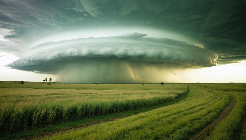
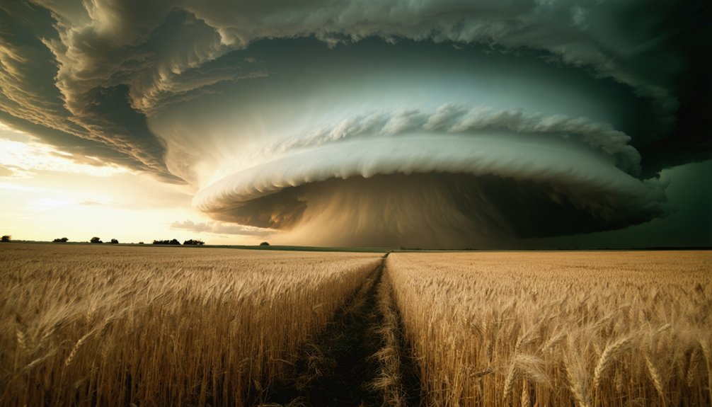
Supercell Thunderstorms: Nature’s Tornado Factories
Among all thunderstorm types, supercells stand alone as nature’s most formidable atmospheric engines—rotating behemoths that produce nearly every violent EF4-EF5 tornado. You’ll recognize these rare storms (less than 1% of thunderstorms) by their shelf like anvils jutting forward and distinctive hook echo on radar.
Strong vertical wind shear transforms horizontal rotation into the deep, persistent mesocyclone—updrafts exceeding 130 ft/s that enable massive hailstone production, suspending grapefruit-sized projectiles aloft. When the capping inversion breaks, explosive development follows. The rear flank downdraft becomes critical for tornadogenesis, wrapping precipitation around the rotation.
These long-lived systems (2-6 hours) demand your respect: 70+ mph winds, baseball-sized hail, and the most destructive tornadoes nature manufactures.
The Mesocyclone: Understanding the Rotating Updraft
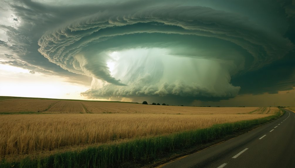
When you’re tracking a supercell, the mesocyclone—a rotating column of air spanning up to 10 miles wide and extending to 50,000 feet—serves as the storm’s rotating engine. This deep, persistent rotation develops when wind shear tilts horizontal vorticity vertical, and the updraft stretches the column to velocities exceeding 100 mph.
As the mesocyclone descends and tightens, it produces a wall cloud at its base where low-level spin concentrates—the critical zone where tornadoes form.
Supercell’s Deep Rotating Core
Several miles wide and extending deep into the storm’s core, a mesocyclone represents the rotating engine that powers supercell thunderstorms. You’ll find this cyclonically rotating updraft spinning counterclockwise in the Northern Hemisphere, driven by significant vertical wind shear that tilts horizontal vorticity into a vertical orientation.
The structure spans at least one kilometer wide and several kilometers tall, with mesocyclone intensity directly correlating to tornado potential.
Doppler radar reveals the signature through stark velocity differentials—you’re looking for rapid shifts between inbound and outbound winds. The precipitation distribution creates a distinctive hook echo as rain wraps around the rotation. While not every mesocyclone spawns tornadoes, it’s the essential precursor. You can’t have supercell tornadoes without this deep rotating core first establishing itself.
Mesocyclone Descends Forming Wall Cloud
Deep within the supercell’s core, horizontal spinning motions encounter the storm’s powerful updraft, which tilts these invisible tubes of rotating air into a vertical orientation. As conservation of angular momentum tightens this rotation, the mesocyclone’s low pressure concentration intensifies, dropping 10 millibars below surrounding air.
You’ll observe the mid-level rotation beginning its descent toward the surface, aided by rear flank downdraft interactions that consolidate the vortex. This descending circulation creates a localized lowering of the cloud base—the wall cloud. Watch for this dark, rotating protrusion extending from the main storm base. It’s your visual confirmation that the mesocyclone has reached ground-level proximity, marking the critical shift toward potential tornadogenesis.
Low-Level Spin Requirements
The mesocyclone—a rotating column of air spanning up to 10 miles wide and towering 50,000 feet high—serves as the supercell’s rotating engine, its sustained circulation detectable by Doppler radar 20 to 60 minutes before potential tornado formation.
You’ll need robust low-level spin to generate tornadoes. Convergence, boundaries, and stretching amplify vertical vorticity as the updraft’s pressure field reorganizes curvature.
The low-pressure center contracts, tightening the gradient and accelerating rotation to 100 mph in strong cases. Low level moisture ingestion fuels buoyancy, intensifying stretching mechanisms. Low level storm inflow carries horizontal vorticity that tilts vertically through the updraft. This process, combined with vertical stretching that narrows the column and conserves angular momentum, transforms mid-level mesocyclone rotation into concentrated surface-based circulation—the critical precursor to tornadogenesis.
Low-Level Moisture and Wind: Setting the Stage for Tornadogenesis
Moisture-laden air masses with elevated dew points serve as the fundamental energy source that transforms ordinary thunderstorms into tornadic supercells. You’ll need a favorable moisture profile with dew points exceeding 60°F at the surface, creating atmospheric instability that fuels powerful updrafts.
High humidity lowers cloud bases to approximately 2,000 feet, producing Lifted Condensation Levels within 750 meters—optimal for tornadogenesis. The low-level jet transports Gulf moisture northward, generating available storm energy while establishing low level baroclinic zones where temperature gradients sharpen.
Meanwhile, extreme low-level wind shear exceeding 50 mph between ground level and cloud base generates streamwise vorticity. This rotation tilts upward within updrafts, initiating mesocyclone development. Without these precise conditions working simultaneously, tornadic potential collapses.
The Rear Flank Downdraft: Tightening the Spin
Behind every violent tornado, a critical atmospheric mechanism drives the tightening vortex—the rear flank downdraft (RFD).
You’ll recognize this descending air mass as the clear slot wrapping around the wall cloud’s rear side. Mid-level air forced downward interacts with the mesocyclone, creating the hook echo signature on radar. What matters most? RFD velocity and RFD thermal contrast across the downdraft’s edge determine tornado potential.
The RFD intensifies rotation through:
- Downward transport of angular momentum creating tangential acceleration
- Convergence promotion on the developing tornado’s back side
- Recycling of downdraft air that fuels the positive feedback loop
- Tilting of low-level vorticity within the circulation
When RFD surges tighten around existing rotation, you’re witnessing nature’s spin-up mechanism—the moment when atmospheric physics transforms supercells into tornado producers.
From Horizontal to Vertical: How Rotation Tilts and Intensifies
Before rotation can spawn a tornado, atmospheric physics must first convert horizontal spin into vertical vorticity. You’ll observe this transformation when storm updrafts tilt streamwise vorticity—created by wind shear in the boundary layer—from horizontal to vertical alignment. This tilting mechanism initiates angular momentum generation within the mesocyclone.
Once vertical, stretching vorticity becomes critical. Updrafts advect the mesocyclone upward at 25-60 m/s, concentrating rotation into narrower columns with accelerated spin rates. Central jets can reach 80 m/s through the vortex core. This stretching process intensifies what begins as broad rotation into focused, violent circulation.
The boundary layer’s horizontal rotation—predominantly cyclonic due to Coriolis forcing—explains why less than 5% of Northern Hemisphere tornadoes rotate anticyclonically. Understanding this tilting-then-stretching sequence gives you predictive power when evaluating tornadic potential.
Geography Matters: Why Tornado Alley Is Where It Is
Tornado Alley’s geographic position stems from a unique continental-scale collision zone where three distinct air masses converge with minimal topographic interference. You’ll find this region spanning from Texas through the Great Plains because:
- Warm, moist Gulf air flows northward unimpeded across flat terrain
- Cold Canadian air masses advance southward without mountain barriers
- Dry Rocky Mountain air descends eastward, creating indispensable wind shear
- Flat landscape allows supercells to intensify and rotate efficiently
The Great Plains’ minimal surface roughness preserves wind speed variations essential for tornado formation. However, shifting regional boundaries now extend activity eastward. Increased Gulf moisture pushes storm convergence toward the Mississippi Valley and Southeast, where forested terrain complicates detection but doesn’t prevent formation.
You’re witnessing a continental-scale atmospheric battleground.
Frequently Asked Questions
What Time of Day Do Most Tornadoes Typically Occur?
You’ll find peak tornado activity between 3 p.m. and 9 p.m., with maximum frequency from 5-6 p.m. Diurnal tornado patterns show afternoon heating drives convection, while dawn sees minimal activity due to cooler temperatures and reduced atmospheric instability.
How Much Advance Warning Do Meteorologists Provide Before Tornadoes Strike?
You’ll typically receive about 15 minutes advance warning before a tornado strikes, though tornado forecasting challenges can extend this to over an hour in some cases. Advance warning capabilities have improved dramatically since 1974, when warnings often came too late.
Can Tornadoes Form Over Water or Only on Land?
You’ll witness tornado formation over water through two types: fair-weather waterspouts that develop directly on water, and tornadic waterspouts as precursors to tornadoes—genuine tornadoes shifting from land to water, maintaining their destructive mesocyclone structure throughout.
What Is the Difference Between a Tornado Watch and Warning?
A tornado watch means conditions favor formation—you’re free to continue activities while monitoring. A tornado warning means one’s detected by radar or spotted—you must take immediate shelter. Tornado monitoring systems issue watches regionally, warnings locally when threats materialize.
How Long Does an Average Tornado Last on the Ground?
Like a fleeting wildfire, most tornadoes you’ll encounter have brief storm duration—typically 5-10 minutes on the ground. However, tornado persistence varies dramatically by intensity, with weaker EF0-EF1 events lasting just 3-5 minutes before dissipating.

