You’ll find the most photogenic storms in America tearing across the wide-open skies of the Great Plains, where supercells build unchallenged from the flat Texas Panhandle north through Oklahoma, Kansas, and into the high plains of Colorado and Nebraska. These landscapes give you unobstructed sightlines, dramatic lighting contrast, and room to position yourself strategically. Peak season runs March through May, but summer zones push the action further. There’s far more to uncover if you keep going.
Key Takeaways
- The Great Plains, from Texas to Colorado, offers wide-open landscapes where towering supercells rise without obstructions, making it ideal for storm photography.
- Peak storm season runs from March to May, with predictable afternoon supercells forming across southern Oklahoma and northeast Texas.
- Colorado’s northeast high plains produce dramatic, often-overlooked supercells with unobstructed 360-degree sightlines and high-contrast lighting conditions.
- Summer severe weather extends beyond Tornado Alley, with notable opportunities in the High Plains, Southern Mid-Atlantic, and Canada’s Manitoba prairies.
- Positioning on a storm’s western flank during golden hour maximizes light contrast and produces the most visually dramatic storm photographs.
Why the Great Plains Are Unbeatable for Storm Photography
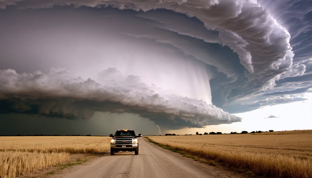
When it comes to storm photography, nothing rivals the Great Plains — wide-open landscapes stretching from Texas through Kansas and into Colorado, where towering supercells build into breathtaking, fully-exposed structures with no treelines or mountain ridges to obstruct your shot.
The Great Plains offer storm photographers an unmatched canvas — endless skies where supercells rise unobstructed in full, dramatic glory.
You’ll maximize visual impact by positioning yourself on the storm’s west side, where light contrast sharpens every rotating wall cloud and inflow band. Understanding storm dynamics and weather patterns lets you anticipate structure before it peaks, giving your landscape composition a decisive edge.
Smart chase strategies mean you’re moving with purpose, not luck. Apply solid photography techniques — wide angles, low horizons, golden-hour timing — and you’ll capture images that feel genuinely immense.
You’re free out here, but always prioritize safety measures; calculated positioning protects both you and your shot.
What Makes a Storm Worth Photographing: Structure, Light, and Position
Not every storm deserves your memory card — the ones worth chasing combine three decisive elements: dramatic structure, quality light, and your strategic position relative to both.
Master storm dynamics first. Supercells with rotating wall clouds and layered cloud formations reward chase preparation and precise weather forecasting.
You’ll want to position yourself on the storm’s western flank, where light conditions create maximum contrast between the inflow base and anvil spread overhead.
Your photographic techniques determine everything else. Timing strategies matter — golden hour backlight transforms an ordinary mesocyclone into something extraordinary.
Composition tips reinforce this: foreground elements anchor chaotic skies. Equipment essentials include wide-angle lenses and fast shutter speeds to freeze structure.
Storm safety isn’t optional — it’s what keeps you free to chase again tomorrow.
Tornado Alley’s Best Storm Photography Season in Texas and Oklahoma
Spring transforms northeast Texas and southern Oklahoma into the world’s most productive severe weather laboratory, running a tight window from March through May that storm photographers shouldn’t miss.
Tornado season peaks here, delivering jaw-dropping supercell structure across flat, unobstructed terrain built for wide-angle compositions.
- Storms fire predictably across southern Oklahoma and northeast Texas afternoons
- Supercell structure towers visibly for miles in open Great Plains landscapes
- March through May concentrates your highest-probability shooting windows
- West-side storm positioning delivers maximum contrast and dramatic lighting
- Experienced chasers like Mike Olbinski have documented historically unique tornadoes here
You’re operating in an environment where the atmosphere practically performs on cue.
Position yourself correctly, understand boundary interactions, and you’ll capture imagery that defines what severe weather photography actually looks like.
The Best Summer Storm Photography Zones Beyond Tornado Alley
Once summer arrives, you’ll find the severe weather action fracturing well beyond Tornado Alley’s classic boundaries.
You can chase spectacular storms east of the Rockies on the High Plains, where upslope flow fuels large hail and damaging winds through June and July, or track explosive afternoon thunderstorms across the Carolinas, where colliding Gulf and Atlantic moisture ignites violent convection.
Mesoscale systems that fire in northeast Colorado overnight and reactivate across the Ohio Valley by morning give you yet another high-contrast, photogenic target worth pursuing.
Summer Hot Spots Explored
As spring’s energy fades from the Southern Plains, three distinct summer hot spots emerge for storm photographers willing to venture beyond Tornado Alley.
Understanding summer storm dynamics reshapes your entire approach to storm photography techniques.
- High Plains east of the Rockies: Upslope flow fuels large hail and damaging winds through June-July.
- Southern Mid-Atlantic (Carolinas): Gulf and Atlantic moisture collide, producing explosive afternoon thunderstorms.
- Ohio Valley: Overnight mesoscale systems born in Colorado reactivate across Illinois, Indiana, and Ohio by morning.
- West sides of boundary storms: High-contrast lighting creates dramatically structured compositions.
- Canada’s southern prairies: Manitoba supercells deliver stunning photogenic opportunities rivaling anything in the continental U.S.
Each zone demands different positioning strategies, but all reward photographers who chase aggressively and read atmospheric boundaries precisely.
Chasing Beyond The Plains
Beyond Tornado Alley’s classic spring window, summer rewires the entire severe weather map — and if you’re willing to chase those shifts, you’ll find photogenic storms rivaling anything the Southern Plains delivers.
Upslope flow east of the Rockies ignites explosive High Plains supercells through June and July, hammering the landscape with large hail and dramatic structure. The Carolinas erupt with Gulf and Atlantic moisture-fueled afternoon towers, while overnight mesoscale systems born in Colorado reactivate across the Ohio Valley by morning.
Each zone demands sharp storm tracking to intercept ideal positioning before storms cluster and lose structure. Pack your photography gear accordingly — wide-angle lenses capture sprawling anvils across open terrain, while fast glass locks in lightning against humid eastern skies.
Freedom means following the atmosphere wherever it leads.
Colorado’s Underrated Storm Photography Scene
When upslope flow pushes moist air eastward into the Rockies, Colorado transforms into a severe weather engine that most photographers overlook entirely.
By afternoon, you’ll watch discrete supercells erupt across northeast Colorado’s high plains, then consolidate into fast-moving clusters that race eastward across wide-open terrain.
You can chase these storms through some of the most unobstructed landscapes in North America, where sprawling skies give you the visual depth and structural clarity that make Great Plains storm photography legendary.
Colorado’s Upslope Weather Magic
Colorado doesn’t get the same storm-chasing glory as Oklahoma or Texas, yet its upslope flow dynamics consistently manufacture some of the most structurally dramatic supercells in the country.
When moist air pushes eastward against the Rockies, the atmospheric contrast creates explosive storm aesthetics you won’t find elsewhere.
Northeast Colorado afternoons transform into a live laboratory of severe weather:
- Upslope dynamics force moisture collisions that produce towering, photogenic supercells
- Wide eastern plains deliver unobstructed 360-degree sightlines
- Back-side storm boundaries generate high-contrast lighting conditions
- Large hail and damaging winds accompany visually striking structures
- Storms cluster and push eastward, offering extended chase windows
You’re not just witnessing weather — you’re watching raw atmospheric mechanics unfold across an uncompromising landscape built for freedom-seekers and serious storm photographers alike.
Northeast Colorado Storm Clusters
What begins as isolated afternoon supercells along the Front Range quickly organizes into something far more complex — storm clusters that sweep northeast Colorado’s open plains with relentless energy.
Northeast Colorado storm patterns develop fast, often catching photographers off guard with their rapid organizational phase. You’ll watch discrete cells merge into sprawling clusters, their bases darkening as updrafts compete and consolidate.
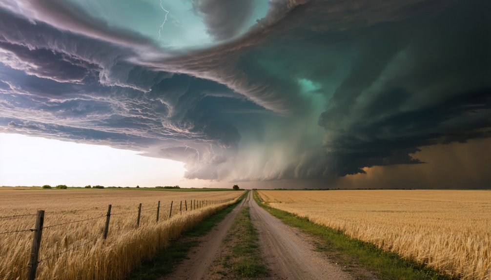
Storm cluster dynamics here create layered visual drama — anvils stacking against Rocky Mountain backdrops while lightning threads through charging rain cores. Roads run straight and flat, giving you unobstructed sightlines across miles of open terrain.
These clusters typically push eastward by late afternoon, delivering your best structural shots before sunset light ignites the whole system.
Position yourself ahead, stay mobile, and you’ll capture sequences that few photographers even know exist.
Chasing Colorado’s Open Landscapes
Few storm photographers realize how dramatically Colorado’s open landscapes transform the moment a supercell anchors itself over the eastern plains.
You’ve got unlimited foreground, massive sky, and brutal contrast — everything storm composition demands.
Chase northeastern Colorado afternoons when upslope flow ignites development fast:
- Flat terrain stretches uninterrupted, letting you frame full wall clouds without obstruction
- Afternoon storms build vertically with sharp anvil definition against blue skies
- West-side boundaries deliver high-contrast lighting for dramatic structural shots
- Road grids run predictably, keeping you repositioned ahead of eastward-moving clusters
- Golden-hour light occasionally catches rotating updrafts, creating cinematic color gradients
You’re not just documenting weather here — you’re owning the composition entirely.
Colorado’s landscapes hand you creative control that crowded southern plains locations rarely offer.
Move early, stay aggressive, shoot freely.
Where to Stand for the Most Dramatic Storm Shots
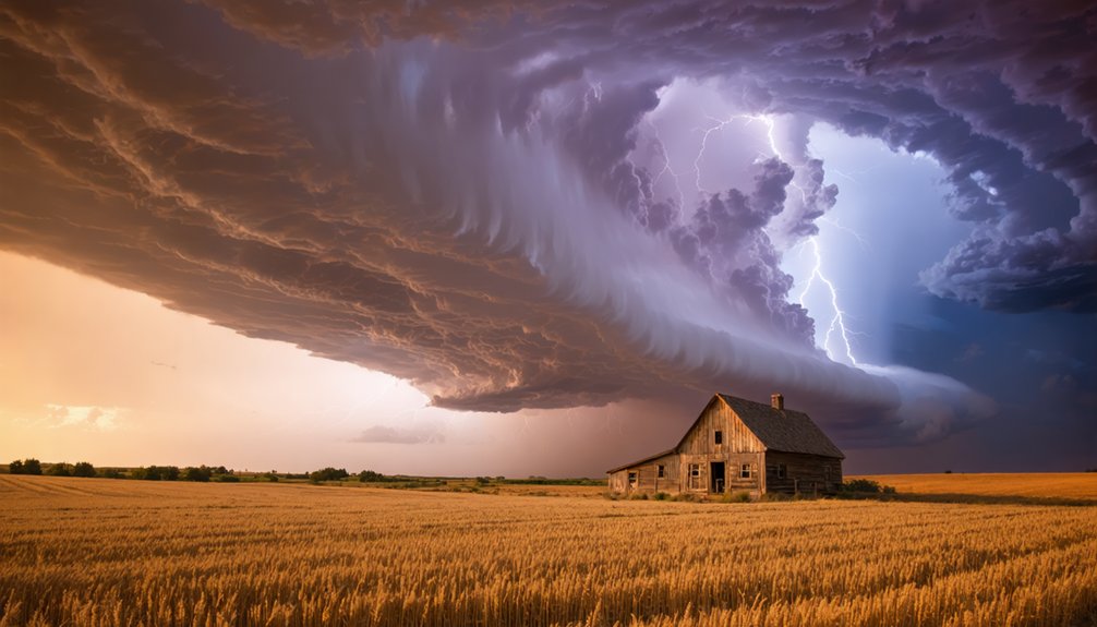
Positioning yourself correctly can mean the difference between a forgettable snapshot and a jaw-dropping image that captures a supercell’s full fury. Master your storm positioning by heading to the storm’s back side — the west-facing edge along atmospheric boundaries. This angle delivers maximum contrast, where dark, churning wall clouds collide against brighter skies, creating raw visual tension.
Your best photography angles emerge from the Great Plains‘ wide-open spaces. Flat terrain lets you frame towering supercells from base to anvil without obstruction.
Push closer to the storm’s western flank, keeping escape routes clear behind you. Low angles amplify a tornado’s scale against open horizons, while mid-distance shots reveal the supercell’s full rotating structure.
Every position decision balances compositional power with calculated risk — freedom earned through disciplined awareness.
Storm Photography Safety: How to Shoot Without Taking Stupid Risks
Chasing storms without a safety framework isn’t adventurous — it’s reckless.
Storm photography ethics demand you respect both the storm and yourself. Equipment safety keeps you mobile and alive.
Follow these non-negotiables before you shoot:
- Know your escape routes — always position your vehicle pointing away from the storm’s core
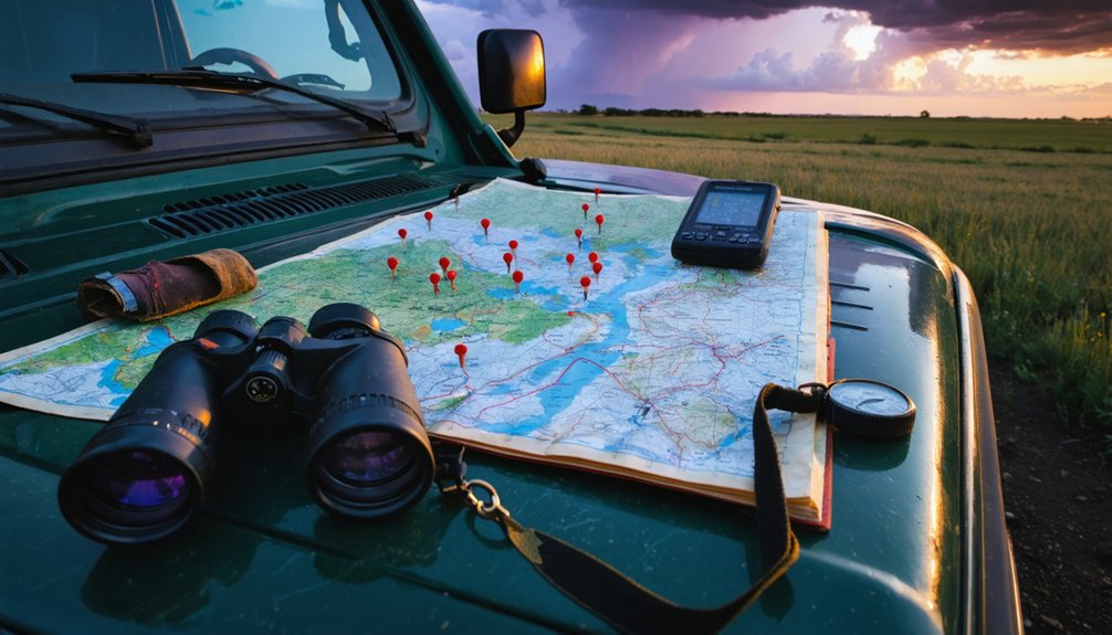
- Monitor radar actively — use apps like RadarScope to track rotation and storm movement in real time
- Never chase alone — a co-pilot watches the storm while you drive
- Protect your gear — weatherproof your camera body; hail destroys equipment instantly
- Respect boundaries — don’t cross flooded roads chasing a perfect shot; no image justifies drowning
Freedom means making calculated decisions, not careless ones.
Smart chasers live to shoot another storm.
Frequently Asked Questions
What Camera Gear Is Best Suited for Storm Photography in the Field?
Ironically, the calmer your gear, the wilder your shots. You’ll need wide-angle lens selection to capture towering supercells, tripod stability to freeze lightning’s chaos, and weather-sealed bodies to survive the storm’s fury with you.
How Do I Find and Join an Experienced Storm Chasing Group or Tour?
Search reputable storm chasing tour companies like those led by Mike Olbinski, verify their safety protocols, read Stormtrack forums, and you’ll connect with experienced chasers who’ll guide you safely into Tornado Alley’s most breathtaking supercells.
Can Storm Photography Be Done Profitably as a Freelance or Commercial Career?
You’re striking gold in a lightning bolt—storm techniques like high-contrast supercell photography reveal real freelance opportunities. Sell dramatic Great Plains images to media outlets, agencies, and brands craving nature’s raw, untamed power.
What Weather Apps and Forecasting Tools Do Storm Photographers Rely on Most?
You’ll rely on Storm Prediction Center outlooks, RadarScope for storm tracking, and Pivotal Weather for analyzing weather patterns. These tools sharpen your instincts, letting you intercept jaw-dropping supercells across the untamed Great Plains with precision and confidence.
How Do Unpredictable Storm Movements Affect Travel and Accommodation Planning?
You’ll need travel flexibility when unpredictable storm patterns shift suddenly. Book refundable accommodation options near target zones, keep safety precautions ready, and stay mobile—chasing freedom means abandoning rigid itineraries and following dynamic, ever-changing severe weather wherever it violently erupts.
References
- https://stormtrack.org/threads/unique-and-photogenic-tornadoes-tell-your-stories.27013/
- https://www.climate.gov/news-features/videos/historically-speaking-where-are-summer-“hot-spots”-severe-weather-us
- https://www.sandraherber.com/storms-of-the-great-plains
- https://www.stormchasingusa.com/blog/day-12-photogenique-storms/