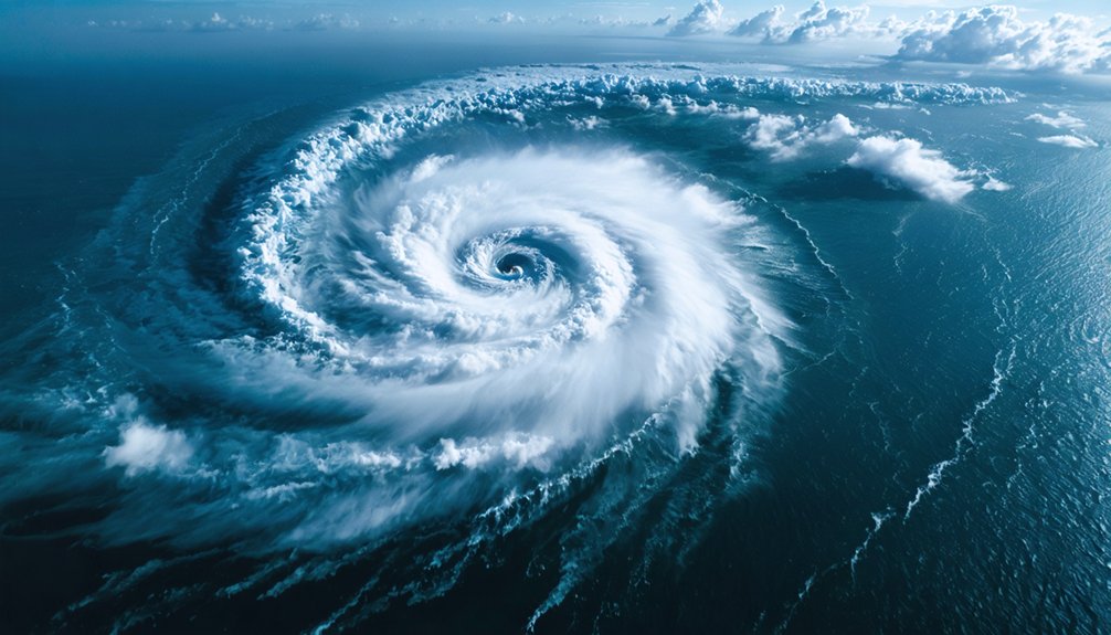
Satellites give you continuous, real-time coverage of severe weather that ground-based radar simply can’t match. GOES satellites scan the Continental U.S. every five minutes and severe weather zones every 30–60 seconds, tracking cloud motion, lightning activity, and moisture systems before conditions turn deadly. They monitor fires, floods, and air quality simultaneously, delivering actionable intelligence across terrain where radar networks don’t exist. Keep exploring to understand exactly how these systems protect you before the worst storms strike.
Key Takeaways
- Satellites orbit 22,300 miles above Earth, providing continuous real-time weather coverage across vast regions every 5–15 minutes.
- They detect critical storm indicators like overshooting tops and lightning bursts, enabling earlier, more accurate tornado and severe weather warnings.
- Satellites monitor fires, floods, and air quality simultaneously, delivering comprehensive operational data essential for emergency management decisions.
- In areas lacking ground-based radar, satellites serve as the primary tool for detecting and tracking severe weather development.
- Advanced AI and imaging technologies will automate storm pattern detection, improving forecast accuracy and severe weather identification capabilities.
How Do Satellites Watch Storms in Real Time?
Orbiting approximately 22,300 miles above Earth, GOES satellites deliver continuous, real-time coverage of severe weather across the U.S., Atlantic, and Pacific regions. This satellite technology gives you uninterrupted storm tracking capabilities, scanning the Western Hemisphere every 15 minutes, the Continental U.S. every 5 minutes, and severe weather zones every 30-60 seconds simultaneously.
The Advanced Baseline Imager enhances this capability by delivering three times more detail about cloud properties and atmospheric conditions than older systems. You’re getting precise detection of overshooting tops, gravity waves, and above-anvil cirrus plumes — all critical indicators of developing severe weather.
During active storm events, rapid 30-second update cycles allow forecasters to monitor storm progression in near real-time, translating raw satellite data into actionable intelligence before conditions deteriorate.
What Makes GOES Satellites More Effective Than Older Systems?
The real-time capabilities you’ve just seen depend heavily on hardware improvements that separate GOES satellites from their predecessors. Understanding GOES advantages means recognizing how satellite evolution has redefined storm monitoring’s precision and speed.
The Advanced Baseline Imager delivers three times more detail about cloud properties than older systems provided. You’re getting simultaneous multi-tasking coverage: the Western Hemisphere every 15 minutes, the Continental U.S. every 5 minutes, and severe weather zones every 30-60 seconds.
Triple the cloud detail. Full hemisphere scans every 15 minutes. Severe weather zones monitored every 30 seconds.
Older satellites couldn’t match that operational flexibility. GOES systems also identify overshooting tops, gravity waves, and above-anvil cirrus plumes that signal severe weather development before conditions escalate.
These hardware upgrades translate directly into faster, more accurate warnings, giving you and emergency management systems the response time needed to act before critical conditions arrive.
How Does Satellite Data Trigger Earlier Tornado Warnings?
When a severe storm develops, you can track its tornado-spawning potential through cloud motion analysis and real-time lightning data, even though satellites can’t directly observe tornadoes on the ground.
Cloud Motion Lightning Tracking
Satellites can’t see tornadoes directly, but they track the cloud motion and lightning activity that reveals a storm’s tornado-spawning potential.
By analyzing storm patterns and tornado dynamics, meteorologists identify dangerous conditions before they reach the ground.
Three critical tracking indicators you should understand:
- Overshooting tops — violent updrafts punching above the anvil cloud, signaling extreme atmospheric instability within a supercell’s core.
- Above-anvil cirrus plumes — ejected ice crystals streaming downwind, indicating explosive energy release that correlates with severe tornado dynamics.
- Lightning burst acceleration — rapid increases in strike frequency, detected every 2.5 minutes, revealing intensifying storm patterns before touchdown occurs.
This data empowers you with earlier warnings, giving emergency systems critical minutes to alert communities before conditions turn catastrophic.
Earlier Warning System Delivery
By integrating continuous satellite observations with ground-based radar and surface data, forecasters trigger earlier tornado warnings through a cascading detection process that begins well before rotation reaches the surface.
Satellites identify overshooting tops, above-anvil cirrus plumes, and rapid intensification signatures that precede surface-level threats. These indicators feed directly into warning algorithms, compressing the gap between storm development and public notification.
Early detection depends on your system’s ability to process multi-source data simultaneously. GOES-16 delivers mesoscale scans every 30 seconds, allowing forecasters to track convective evolution in near real-time.
Warning accuracy improves considerably when satellite data confirms radar-identified rotation, reducing false alarm rates. You gain additional lead time—sometimes several critical minutes—enabling emergency managers to issue evacuation directives before conditions become life-threatening.
Can Satellites Predict Exactly Where Wind Damage Will Hit?
How precisely can satellites pinpoint where wind damage will strike? Despite satellite limitations, microwave data integration notably sharpens wind damage prediction capabilities, giving you actionable intelligence before destruction arrives.
Here’s what satellites actually deliver:
- Storm-scale targeting — Computer models incorporating satellite data consistently highlight the most powerful wind corridors within severe storms, narrowing damage zones to specific regions.
- Surface gust mapping — Microwave imagery identifies where the strongest gusts will concentrate, letting forecasters visualize destructive wind channels before impact.
- Pre-event damage forecasting — Meteorologists can pinpoint highest-risk zones before conditions turn critical, giving you time to act decisively.
Satellites won’t mark your exact address, but they’ll identify your neighborhood’s threat level with remarkable precision.
How Do Satellites Track Fires, Floods, and Air Quality During Disasters?

When a disaster strikes, you can rely on satellites to simultaneously track fires, monitor floods, and measure air quality changes across vast regions in near real-time.
GOES satellites detect lightning strikes most likely to ignite fires, monitor fire intensity, and track smoke and aerosol dispersion for air quality assessment.
Advanced imaging systems also identify atmospheric rivers driving catastrophic flooding, giving you an extensive, multi-hazard picture of unfolding disasters.
Fire Detection From Space
Satellites don’t just track storms—they’re also critical tools for monitoring wildfires, floods, and air quality during active disasters.
Through satellite monitoring, you gain unobstructed visibility over vast, inaccessible terrain where ground crews can’t operate freely.
Here’s what fire detection from space delivers:
- Fire ignition identification — Satellites pinpoint lightning strikes most likely to trigger ignition events before flames spread beyond containment range.
- Real-time intensity mapping — Thermal sensors measure fire heat output, revealing which zones burn hottest and require immediate resource deployment.
- Smoke and aerosol tracking — Satellites trace airborne particulates across hundreds of miles, giving you accurate air quality data to make informed evacuation decisions.
This capability transforms your situational awareness, letting you act decisively before conditions deteriorate beyond control.
Flood Monitoring Via Satellites
Flood monitoring relies on satellite-borne Synthetic Aperture Radar (SAR) imagery, which penetrates cloud cover and darkness to deliver accurate inundation maps regardless of weather conditions or time of day.
You get precise flood mapping that ground-based systems simply can’t match across large, terrain-obstructed regions.
Satellites collect optical, LiDAR, and radar data simultaneously, giving emergency managers a thorough operational picture.
This multi-sensor approach lets you identify which infrastructure sectors face immediate risk, enabling restoration teams to dispatch resources to high-priority zones without delay.
Satellite imagery also supports atmospheric river monitoring, detecting moisture-laden systems that trigger flooding and mudslides before they strike.
Tracking Air Quality Changes
During disasters, aerosol and smoke tracking satellites monitor dust, smoke, and particulate matter in near real-time, giving you a continuous picture of air quality degradation across affected regions.
Advanced satellite sensors cut through terrain barriers and weather conditions, delivering independent environmental monitoring that no ground-based network can match alone.
Key pollution tracking capabilities include:
- Aerosol detection — satellites map smoke plumes spreading hundreds of miles from wildfire zones, showing you exact contamination boundaries.
- Dust storm surveillance — sensors identify airborne particle concentrations moving across regions, letting communities prepare protective measures.
- Multi-layered atmospheric profiling — satellites measure pollution at varying altitudes, revealing how toxic air quality layers travel and disperse.
This data empowers you to make informed decisions about evacuation, shelter-in-place protocols, and resource deployment without depending on centralized reporting systems.
Why Satellite Storm Monitoring Matters Most Where Radar Can’t Reach
Where ground-based radar networks thin out or disappear entirely, satellite storm monitoring becomes the primary—and often only—reliable tool for detecting severe weather. In rural coverage gaps across West Africa and remote regions worldwide, radar infrastructure simply doesn’t exist. You’re left dependent on satellite data to identify dangerous storm development before it threatens lives.
Satellite limitations remain real—orbital geometry and resolution constraints mean you won’t detect every localized feature ground radar catches. However, geostationary satellites compensate by delivering continuous, wide-area atmospheric monitoring regardless of terrain, time, or conditions.
When forecasters incorporate microwave data from low-Earth-orbiting satellites into computer models, those models consistently identify the strongest storms and most dangerous wind damage zones—giving you actionable intelligence where no ground-based system can operate.
What’s Next for Satellite Weather Technology?
The next generation of satellite weather technology will fundamentally change how you receive storm warnings and forecasts.
AI advancements will automatically detect emerging weather patterns, eliminating delays caused by manual analysis. Future imaging systems will deliver ultra-high-definition, near real-time 3D storm visualizations, giving you unprecedented clarity on developing threats.
Three capabilities redefining your weather awareness:
- AI-driven pattern recognition — algorithms scanning satellite feeds continuously, flagging severe storm signatures seconds after formation
- Ultra-HD future imaging — three-dimensional storm structure mapping that reveals intensity changes before conditions turn dangerous
- Meteosat Third Generation upgrades — 2.5-minute resolution imagery combined with precision lightning tracking, sharpening short-term forecast accuracy
These technologies won’t just improve forecasts — they’ll give you more time to act, protect your property, and make independent decisions before storms arrive.
Frequently Asked Questions
How Do Satellites Continue Monitoring Storms During Complete Ground Infrastructure Failures?
Orbiting 22,300 miles above darkened, powerless cities, satellites maintain your storm tracking independently. Their satellite resilience means they’re continuously scanning every 30 seconds, delivering critical weather data regardless of collapsed ground infrastructure below.
What Specific Satellite Data Types Support Hurricane Evacuation Route Planning Decisions?
You’ll rely on optical, radar, and SAR satellite imagery for evacuation mapping, combined with hurricane tracking intensity data that’ll pinpoint storm paths and strength changes, empowering your independent decision-making before conditions become critical.
How Frequently Do Meteorologists Receive Updated Lightning Strike Data From Geostationary Satellites?
You’ll receive lightning detection updates every 2.5 minutes via Meteosat Third Generation satellite technology. This rapid refresh rate lets you track storm intensification systematically, giving you the precise, real-time situational awareness needed for timely, independent weather decisions.
Which Polar-Orbiting Satellites Provide the Highest Resolution Data for Long-Range Forecasting?
While geostationary satellites offer continuous coverage, they can’t match JPSS’s detail—you’ll find these polar-orbiting systems deliver the highest resolution data specifically engineered for long-range forecasting applications, giving you superior global observational accuracy.
How Does AI Technology Automatically Identify Dangerous Emerging Weather Patterns From Satellite Imagery?
AI algorithms automatically scan satellite imagery, detecting emerging storm patterns before they intensify. You’ll benefit as these systems flag dangerous weather prediction signals instantly, empowering you with earlier warnings and reducing your dependence on slower, traditional forecasting methods.
References
- https://www.rmets.org/metmatters/role-satellites-weather-forecasting
- https://www.nesdis.noaa.gov/news/how-noaa-satellites-help-us-stay-ahead-of-severe-weather-season
- https://www.psu.edu/news/research/story/satellite-data-assimilation-improves-forecasts-severe-weather
- https://lpsmanager.io/en/benefits-of-real-time-weather-monitoring/
- https://www.weather.gov/about/satellites
- https://www.ecoonline.com/blog/benefits-of-satellite-tracking/
- https://www.goes-r.gov/mission/mission.html
- https://www.aidash.com/6-highly-effective-ways-satellites-help-utilities-disaster-management/
- https://www.nesdis.noaa.gov/news/orbit-outlook-how-leo-satellites-enhance-weather-forecasting


