You’ll choose customized storm chasing packages because they limit groups to 6-7 passengers in 15-seat vans, guaranteeing window seats and safe 1-2 mile positioning from tornadoes. Guides with 50+ years combined experience analyze CAPE values, deep-layer shear, and 3km HRRR models while employing mobile Doppler radar and lidar technology. These operations maintain zero fatalities across 30+ years through strict safety protocols, GPS tracking, and atmospheric mathematics that handle life-or-death decisions. The sections below detail how expert forecasting and advanced technology maximize your chase success.
Key Takeaways
- Small group sizes with maximum 6-7 passengers guarantee window seats and personalized attention during each storm chasing expedition.
- Expert meteorologists utilize advanced forecasting tools and atmospheric data analysis to position tours safely near active tornadoes.
- Mobile Doppler radar and lidar technology provide real-time storm tracking while maintaining safe 1-2 mile distances from tornado activity.
- Educational briefings teach practical forecasting techniques, radar interpretation, and atmospheric parameters for hands-on learning experiences.
- Comprehensive safety protocols backed by 50+ years combined experience result in zero participant fatalities over 30+ years of operations.
Intimate Group Experiences Replace Crowded Tour Buses
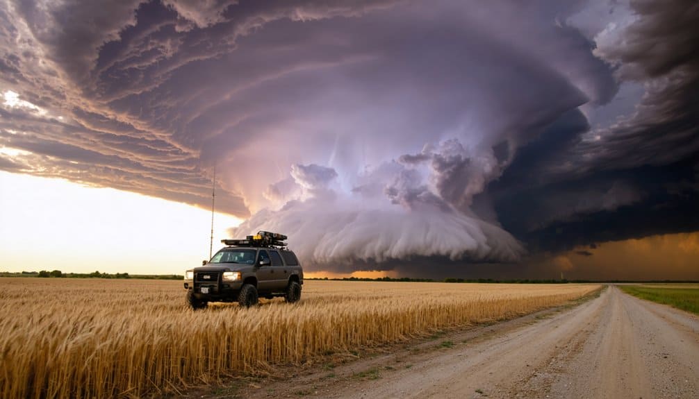
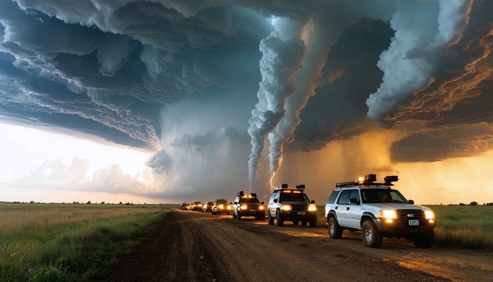
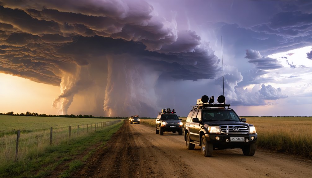
Strip away the chaos of overcrowded tour buses, and you’ll find a fundamentally different approach to storm chasing: intimate van groups capped at six guests per vehicle. These custom-designed 15-passenger vans maintain strict capacity limits—never exceeding 6-7 passengers—ensuring window seats for everyone and eliminating cramped conditions during long-distance pursuits.
Small group dynamics transform your chase experience. With maximum three-vehicle operations per tour, total groups range from eight to 25 participants, enabling safe positioning 1-2 miles from tornadoes without crowding. You’ll access radar viewing stations and observe storms unobstructed while maintaining connectivity through onboard WiFi.
Customized guest experiences replace mass-market touring. Open aisle designs, AC power plugs, USB ports, and 17-inch HD monitors deliver comfort on extended travel days. Higher prices reflect intentional capacity restrictions—prioritizing quality over volume across open plains terrain.
Expert Storm Forecasters Guide Every Chase Decision
Drilling down through layers of atmospheric data, professional meteorologists analyze computer models like the 3km HRRR to identify storm systems developing from troughs or jet stream dips days before you board the chase vehicle. Their human background expertise interprets ensemble clusters, updraft helicity overlays, and Storm Prediction Center risk assessments to pinpoint high-threat zones where supercells will likely form.
Model integration strategies combine satellite imagery with Skew-T soundings, evaluating CAPE values, deep-layer shear exceeding 40 knots, and 0-3km helicity thresholds above 300 for tornado potential. They’ll position you on the storm’s inflow side—typically west-southwest of southeast-moving systems—continuously refining targets as real-time data flows in. You’re free to chase confidently while experts handle the atmospheric mathematics determining life-or-death positioning decisions.
State-of-the-Art Weather Tracking Technology Maximizes Success
While expert forecasters determine where storms will develop, specialized equipment onboard chase vehicles transforms theoretical predictions into real-time tactical advantages.
Advanced mobile technology converts forecast models into actionable intelligence, positioning chase teams precisely where atmospheric drama unfolds with maximum safety and visibility.
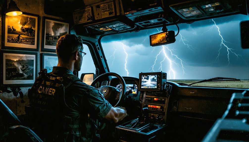
Your tour utilizes cutting edge instrumentation including mobile Doppler radar systems that measure wind speeds and precipitation intensity with pinpoint accuracy. These truck-mounted units detect rotation signatures within developing storms, enabling immediate repositioning to ideal viewing locations.
Advanced lidar technology provides three to 10 times more detail than traditional radar, measuring winds within a kilometer of tornado formations. Ground-level instruments continuously monitor pressure, temperature, and humidity as conditions evolve.
This unprecedented data collection creates an extensive three-dimensional picture of storm behavior, allowing your guide to identify the safest intercept positions while maximizing your chances of witnessing nature’s most powerful phenomena.
Comprehensive Safety Measures Protect All Participants
Advanced technology means nothing without rigorous safety protocols protecting you throughout every chase. You’ll benefit from guides averaging 50+ combined years of experience, all trained in meteorology, emergency response, and Red Cross-certified first aid. Strict safety protocols mandate constant GPS tracking, real-time route alterations, and maintained safe distances from storm centers—never positioning left of a tornado’s mean motion vector.
The statistics validate this professional risk mitigation approach: zero tour participant fatalities across 30+ years of industry operations. Death rates remain under 1 per 250,000 person-days, with only 13 total chaser deaths from 2005-2019 across hundreds of thousands of chase days. You’ll experience mandatory seatbelt compliance, continuous escape route evaluation, and adherence to 10 fundamental chaser safety rules—ensuring your freedom to witness nature’s power without compromising survival.
Educational Briefings Transform Guests Into Informed Weather Enthusiasts

You’ll receive thorough daily weather briefings where meteorologists analyze atmospheric data, model outputs, and surface observations to identify prime chase targets.
These sessions teach you practical forecasting techniques as guides explain environmental parameters like CAPE, shear vectors, and helicity values that drive severe storm development.
Through hands-on analysis of real-time conditions, you’ll learn to interpret radar signatures, hodographs, and mesoscale features that experienced chasers use to position safely near active supercells.
Daily Weather Pattern Analysis
How do storm chasers transform atmospheric chaos into actionable forecasts within a 12-hour window? You’ll start each chase day analyzing atmospheric patterns through SPC mesoanalysis, prioritizing real-time surface observations over model data. This approach reveals moisture boundaries, temperature gradients, and wind convergence zones where storms ignite.
Your daily pattern analysis integrates:
- Surface observations showing frontal positions and low-pressure coalescence
- Convection-allowing models (HRRR, WARF ARW) tracking feature movements hour-by-hour
- Ensemble forecasts combining multiple model runs to reduce weather variability uncertainties
- Radar data monitoring dBZ values and shear quadrants for tornadic potential
- Satellite soundings measuring tropospheric conditions across all atmospheric levels
You’ll learn to identify convergence along cold fronts where weakening caps trigger initiation, transforming classroom theory into field-tested forecasting skills that empower independent storm intercepts.
Hands-On Forecasting Techniques
Forecasting accuracy separates successful storm intercepts from wasted miles, and tour operators deliver this edge through structured educational briefings that decode complex atmospheric data into actionable intelligence. You’ll learn radar based thunderstorm detection through live Doppler analysis, identifying hook echoes and mesocyclone signatures as storms develop.
Guides demonstrate Skew-T diagram interpretation, showing you how to assess CAPE values, wind shear parameters, and updraft helicity that determine tornado potential. Ensemble forecast verification techniques reveal when multiple model runs agree on severe weather timing and location, reducing uncertainty in your target selection.
You’ll monitor satellite imagery for early cumulus development while evaluating storm-relative helicity tracks. This hands-on parameter analysis transforms abstract meteorological concepts into practical forecasting skills you’ll apply throughout each chase day.
Flexible Itineraries Accommodate Every Skill Level and Interest
Whether you’re seeking an adrenaline-fueled 7-day “Extreme” pursuit of intense supercells or a 5-day “Shorty” tour during May’s peak tornado activity, these customized packages adapt to your available time and experience level. Malleable scheduling allows you to combine tours for 12-16 days or book on-call single-day chases.
Expert guides handle forecasting and navigation while you focus on personalized encounters—from photogenic wall clouds to close-range tornado intercepts.
Your tour adapts to:
- Daily weather briefings and safety training for all skill levels
- Dynamic itinerary adjustments based on evolving storm patterns
- Private van reservations for exclusive group experiences
- Interest-based targeting between Southern Plains supercells and Central Plains isolated storms
- Flexible morning meetings adjusted after late-night chases
No experience required—just your desire for unscripted adventure.
Professional Photography Support Captures Once-in-a-Lifetime Moments
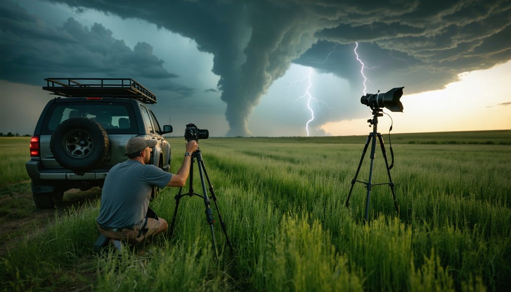
Storm photography demands split-second decisions where composition, exposure, and safety converge—and expert guidance transforms amateur snapshots into portfolio-worthy captures. You’ll master ideal storm exposure techniques through real-time coaching on bulb mode configurations (ISO 100, f/16 for close lightning) and diverse camera capture approaches utilizing ND filters for daytime strikes.
Professional support includes weather-sealed gear recommendations, manual focus protocols at infinity, and RAW+JPEG workflows that preserve editing flexibility. Your instructor establishes safe viewing distances using pre-chase meteorological data while teaching rule-of-thirds composition that balances tornado scale against contextual elements.
Post-chase sessions refine contrast and saturation adjustments. With specialized tripods for long exposures and communication devices ensuring informed repositioning, you’ll document anvil crawlers and supercell structures without compromising your freedom to explore nature’s most dramatic displays.
Customizable Private Tours Deliver Personalized Adventures
Beyond capturing dramatic imagery, your chase experience reaches its full potential when tour parameters align with your specific interests and skill level. Private customizable packages grant enhanced participant control over critical decisions, from target selection to risk thresholds.
You’ll access greater schedule flexibility, pursuing systems that match your meteorological objectives rather than conforming to predetermined itineraries.
Key customization advantages:
- Route autonomy: Direct input on chase corridors and storm selection criteria based on your photographic or scientific priorities
- Pace modification: Adjust positioning strategies and distance-to-storm protocols according to your comfort parameters
- Duration optimization: Extend or reduce daily chase windows aligned with your endurance and available timeframe
- Educational depth: Request detailed mesoscale analysis briefings or streamlined tactical updates
- Vehicle configuration: Specify equipment requirements, seating arrangements, and technology integration for your operational needs
Proven Track Records From Award-Winning Chase Teams
When you’re investing in a storm chasing tour, you’ll want verifiable performance metrics that demonstrate your team’s capability to intercept severe weather safely. Ben Holcomb’s 24.38% tornado day success rate across 406 chase days and 214 documented tornadoes provides quantifiable evidence of consistent forecasting accuracy and intercept execution.
Award-winning teams like Team Dominator bring credentials from the National Storm Chaser Summit, Netflix features, and scientific journal publications—credentials that translate to higher-probability storm encounters backed by proven safety protocols.
Industry Recognition and Awards
Since the mid-1950s, storm chasing has evolved from a solitary pursuit into a professionally recognized field where documented achievements and scientific contributions distinguish elite chase operations from amateur enthusiasts. When you’re selecting a tour provider, professional accolades matter. Industry luminaries have established measurable benchmarks that separate credible operations from reckless ventures.
Top-tier chase teams demonstrate their expertise through:
- Documentary features highlighting research contributions and extreme weather documentation
- Network appearances on CNN, CBS, NBC, and Weather Channel validating operational capabilities
- Scientific recognition for advancing tornado and supercell morphology understanding
- Technology innovation including first HD tornado interior footage and real-time data streaming
- Multi-decade experience with documented intercepts exceeding 1000+ events
You’ll find legitimate operators maintain transparent track records, publish meteorological data, and prioritize participant safety over sensationalism—credentials that directly impact your experience quality.
Documented Success Rate Statistics
While marketing claims saturate the storm chasing industry, quantifiable success metrics reveal stark performance disparities between operators. You’ll find professional tour operators achieving 80% tornado encounter rates on multi-day expeditions, dramatically exceeding Kansas’s baseline 14.3% success rate for individual chase attempts. These success rate trends demonstrate how experienced teams leverage seasonal tornado patterns—particularly late May’s northward jet stream shift—to maximize your intercept probability.
Data from 2013-2019 shows photogenic tornado percentages ranging from 26.7% to 45.5%, with elite operators consistently performing above amateur averages. You’re investing in measurable outcomes: one-third of amateur chasers witness tornadoes, while established tour companies triple those odds. The 849.5 miles-per-tornado metric underscores the precision required. Safety statistics remain favorable with under one chaser death annually from 2005-2019, validating professional protocols over independent attempts.
Frequently Asked Questions
What Is the Average Cost Range for Customized Storm Chasing Tours?
You’ll find customized storm chasing tours range from $2,499 to $5,050 depending on duration. Tour package flexibility and customized itineraries affect pricing, with 5-day options averaging $2,800, while 10-day experiences reach $4,900 for ideal chase conditions.
When Is the Best Time of Year to Book a Tour?
You’ll find the ideal booking period runs late May through early June, when tornado frequency peaks. This prime booking season—specifically May 30-June 8—offers statistically highest intercept rates, maximizing your freedom to witness nature’s raw power safely.
What Physical Fitness Level Is Required to Participate in Storm Chasing?
Storm chasing doesn’t require specific cardiovascular endurance or muscular strength standards. You’ll need moderate fitness for quick vehicle exits, standing outdoors, and occasional short walks. Most participants handle tours comfortably regardless of their current fitness level.
Are Meals and Accommodations Included in the Tour Package Price?
Most operators include accommodations and continental breakfasts, but you’ll cover dinners independently. Premium packages offer tailored lodging arrangements in quality hotels and accommodate specialized dietary requirements. You’re responsible for lunch costs and incidental expenses throughout your chase experience.
What Happens if No Significant Storms Occur During My Tour?
Tours proceed without refund policies regardless of storm activity, since operators commit upfront costs. You’ll receive alternative activities including weather briefings, photography instruction, and forecast analysis. No guarantees exist—nature’s unpredictable, but safety remains prioritized throughout.