You’ll find Texas’s most productive storm chasing in the Red River Valley and western North Texas, where atmospheric convergence generates the nation’s second-highest tornado frequency. Target your chase operations during the April-through-June peak season, particularly May when the state averages 39.38 tornadoes. Position yourself between 4:00 p.m. and 9:00 p.m. when 75% of tornadoes occur. The Dallas-Fort Worth Metroplex and Austin-San Antonio corridor offer additional intercept opportunities with ideal road networks. Understanding specific meteorological patterns and historical outbreak locations will greatly enhance your chase success rate.
Key Takeaways
- Red River Valley in North Texas experiences the highest tornado frequency during peak season months of April through June.
- Dallas-Fort Worth Metroplex serves as an urban storm chasing hub with strategic access to multiple tornado-prone regions.
- Western North Texas sees consistent May activity with 89 April tornadoes and fewer but more violent outbreaks.
- Austin-San Antonio corridor benefits from supercell-conducive conditions when low-pressure systems move through Central Texas.
- May offers optimal chasing conditions statewide, averaging 39.38 tornadoes with activity concentrated between 4:00-9:00 p.m.
Red River Valley: North Texas Tornado Alley
When meteorologists analyze tornado frequency across the continental United States, the Red River Valley of North Texas emerges as a statistically significant hotspot with 5.7 tornadoes per 10,000 square miles—placing Texas 11th nationally in tornado density.
You’ll find peak activity concentrated in April through June, accounting for 62.7% of all tornadoes from 1951-2011, with May alone producing nearly one-third of the state’s annual 132-150 events. Western North Texas averages 3.9 tornadoes annually, chiefly materializing between 4-8 PM when atmospheric instability peaks.
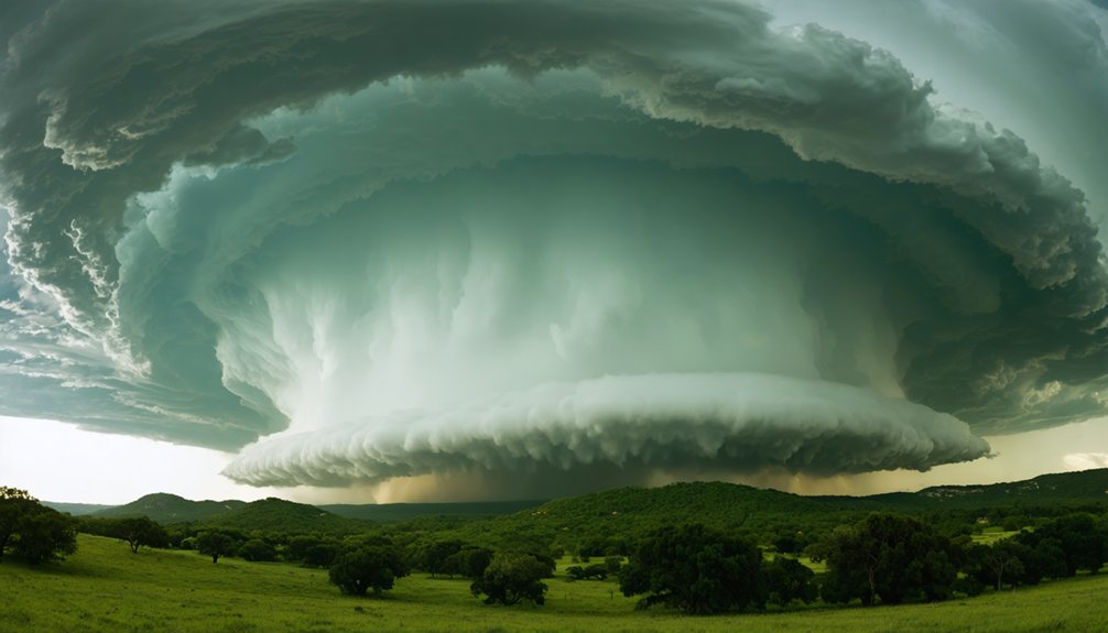
The 1979 outbreak demonstrated the region’s volatile potential: an F5 tornado devastated Wichita Falls with high winds exceeding 80 mph and a 1.5-mile-wide damage path, killing 45 and injuring 1,800. These unpredictable thunderstorms demand constant vigilance and real-time meteorological monitoring.
Dallas-Fort Worth Metroplex: Urban Storm Chasing Hub
Meteorological records from the NWS Fort Worth database reveal the Dallas-Fort Worth Metroplex as a high-frequency tornado corridor, with Dallas, Tarrant, Collin, Denton, and Rockwall counties collectively recording substantial tornado activity across 1,880-2026 tracking periods. You’ll find May peaks at 1.6 tornadoes monthly, while historical data documents 299 total events since 1950.
Storm path dynamics here favor supercell development when Gulf moisture collides with dry continental air masses. The metro’s central positioning grants you rapid deployment capabilities to multiple county hotspots, though urban vulnerability mitigation requires understanding population density intersections with historical F/EF4-F/EF5 tracks.
NWS Fort Worth’s ArcGIS dashboard lets you filter county-specific EF-ratings, optimizing chase decisions. You’re positioned within documented violent tornado zones while maintaining interstate mobility across North Texas’s most active climatological region.
Western North Texas: Consistent May Activity
Western North Texas demonstrates statistically reliable tornado genesis patterns, with May accounting for 42% of the region’s 299 recorded tornadoes since 1950—125 events versus 89 in April. You’ll find the most predictable chase opportunities during this peak month, averaging 1.6 tornadoes annually with recent years like 2021 and 2024 producing 7 and 5 May tornadoes respectively.
April represents your secondary intercept window, offering substantial supercell activity before the seasonal maximum intensifies.
May Dominates Tornado Activity
Since 1950, May has produced 89 documented tornadoes across western North Texas, establishing a monthly average of 1.2 tornadoes and representing the region’s most consistent severe weather window. You’ll find peak patterns align with upper-level jet stream positioning that creates ideal shear profiles during this month.
The data reveals significant monthly variability—May’s 123 tornadoes across broader North Texas substantially outpace April’s 82 and June’s 33 events. When you’re planning chase operations, recognize that May accounts for 30% of western North Texas’s 299 total tornadoes since record-keeping began.
Recent years demonstrate this reliability: 2021 recorded 7 May tornadoes, while 2024 logged 5 events. This statistical consistency provides you predictable deployment windows for intercepting supercells along established corridors near Stephens and Shackelford counties.
April Shows Strong Potential
April emerges as North Texas’s secondary tornado maximum, with historical records documenting 82 tornadoes across the broader region and maintaining a consistent 1.2 monthly average in western counties since 1950. You’ll find high instability conditions during this transitional changeover period create explosive development when frontal boundary interaction aligns with sufficient moisture.
Recent outbreaks demonstrate this potential—April 19 produced ten tornadoes ranging EF-0 to EF-2, while April 2025’s four-day period generated 69 confirmed events. Hood, Parker, and Hill counties represent prime intercept zones where you’ll encounter significant structural impacts. EF-2 classifications dominate the upper intensity threshold, producing complete roof removal and farm equipment displacement.
Year-to-year variability ranges 2-5 monthly events, though concentrated outbreak periods substantially exceed these baseline statistics during ideal atmospheric setups.
Recent Years Trending Upward
May represents the statistical apex for tornado development in western North Texas, with the 1.6-event monthly average climbing to 13 documented tornadoes during the 2015 peak season. You’ll find interannual variability demonstrates pronounced fluctuations: 2020 delivered five events, while 2021 recorded zero May occurrences despite nine annual tornadoes concentrated in March-April.
Frequency comparisons across 2017-2021 reveal oscillating patterns—four tornadoes (2017), one (2018), one (2019)—yet five-year moving averages confirm upward trending in regional counts. Post-2020 data maintains elevated spring-season activity, aligning with national patterns where prolific May-June periods dominate southern Plains meteorology. You’re observing systematic increases in western North Texas May reports, reinforcing this corridor’s classification within classic Tornado Alley parameters alongside Oklahoma and Kansas peak-month convergence.
Austin and San Antonio Corridor: Eastern Texas Hotspot
The Austin-San Antonio corridor represents a shifting zone where Tornado Alley’s influence diminishes southward, producing largely EF0-EF1 tornadoes with historically low casualty rates. Austin County’s 74-year dataset documents 27 tornadoes averaging 3.2 miles in length and 43 yards in width, resulting in zero fatalities and minimal injuries.
You’ll find peak tornadic activity concentrated between 3-7 PM local time during spring months, though flash flooding presents a statistically higher threat than tornado development in this eastern Texas sector.
Prime Tornado Activity Zones
While storm chasers often associate Texas’s most volatile tornado activity with the Panhandle region, the Austin and San Antonio corridor presents a distinct meteorological profile characterized by moderate-high tornado track densities and historically significant severe weather outbreaks.
This Central Texas zone demands strategic positioning for ideal intercepts:
- Peak Activity Window: Position yourself during late afternoon hours (3-7 PM local time) when atmospheric instability maximizes tornado genesis potential
- Historical Severity: The 1997 Jarrell EF5 event demonstrates catastrophic intensity possibilities within this corridor’s meteorological framework
- Urban Impact Risk: Monitor NWS Austin/San Antonio forecasts covering 33 counties where population centers increase structural vulnerability exposure
- Rural Damage Assessments: Track developments in outlying counties like Hays, where recent events produced 6-inch hail exceeding $1 million in agricultural losses
You’ll find unregulated chase opportunities throughout this moderately active corridor.
Seasonal Timing and Patterns
Storm chasers targeting the Austin-San Antonio corridor should concentrate intercept operations within the April-June window, when tornado frequency peaks at 78% of annual regional events based on 1989-2022 NOAA climatological datasets.
You’ll maximize chase opportunities by monitoring gulf moisture influx trajectories during this critical period, as warm maritime air advances northward from the Gulf of Mexico. The collision of air masses intensifies when this humid subtropical flow encounters cooler, drier continental systems descending from the Rockies and Canadian provinces. This atmospheric confrontation generates supercell-conducive environments throughout Central Texas.
While the corridor experiences fewer tornadoes than northern Texas regions, event intensity often exceeds state averages. Deploy resources strategically during May—statistically the most prolific month—when jet stream positioning optimizes severe convective parameters across eastern Texas terrain.
Peak Season Timing: April Through June
Although tornado activity occurs year-round across Texas, April through June represents the state’s definitive peak period, accounting for 62.7% of all tornadoes recorded between 1951 and 2011. This seasonal shift brings peak intensity during May, when nearly one-third of Texas’s annual 132 tornadoes occur, averaging 39.38 events statewide.
Monthly Breakdown for Chase Planning:
- April: 89 tornadoes in western North Texas; less frequent but more violent outbreaks
- May: 125 tornadoes in western North Texas; highest probability month with 39.38 state average
- June: 35 tornadoes in western North Texas; declining activity as systems migrate northward
- Geographic Focus: Red River Valley experiences highest frequency during peak months
You’ll maximize intercept opportunities by concentrating efforts within this three-month window, particularly targeting May’s statistically superior tornado production across North Texas corridors.
Optimal Daily Window: Late Afternoon to Early Evening

Texas tornado occurrence exhibits pronounced diurnal periodicity, with 75% of events concentrated between 4:00 p.m. and 9:00 p.m. This prime chasing window results from ideal meteorological convergence: increased wind shear development, supercell maturation cycles, and dryline dynamics that intensify throughout the day. You’ll find afternoon thunderstorm peaks align with maximum atmospheric instability, as storms require several hours to reach severe-warned status.
Regional variations exist—North Texas maintains severe potential from 3:00 p.m. through midnight, while West Texas experiences concentrated activity between 6:00 p.m. and 9:00 p.m. The remaining 25% of tornadoes occur nocturnally (10:00 p.m. to 6:00 a.m.), presenting heightened danger due to reduced visibility. Strategic positioning during late afternoon maximizes your intercept probability while maintaining adequate daylight for safe navigation and documentation.
Historic Outbreak Locations and Patterns
The Red River Valley of North Texas concentrates the state’s most prolific tornado activity, recording densities remarkably exceeding the statewide average of 5.7 tornadoes per 10,000 square miles between 1951 and 2011. Regional synoptic patterns drive spring outbreaks here, contributing to Texas’s national lead with 132 annual tornadoes.
You’ll find peak activity April through June (62.7% of occurrences), with May averaging 39.38 events monthly.
Notable outbreak patterns you should track:
- May 1982 generated 123 tornadoes, establishing the spring outbreak benchmark
- Hurricane Beulah (1967) spawned 115 tornadoes over five days, including 67 on September 20
- Eastern Texas experienced deadly F4 storm cell structures on May 6, 1930
- Harris County’s 1983 outbreak demonstrates metropolitan vulnerability with multiple F2 touchdowns
Hurricane-driven events reveal outbreak potential beyond typical seasonal windows.
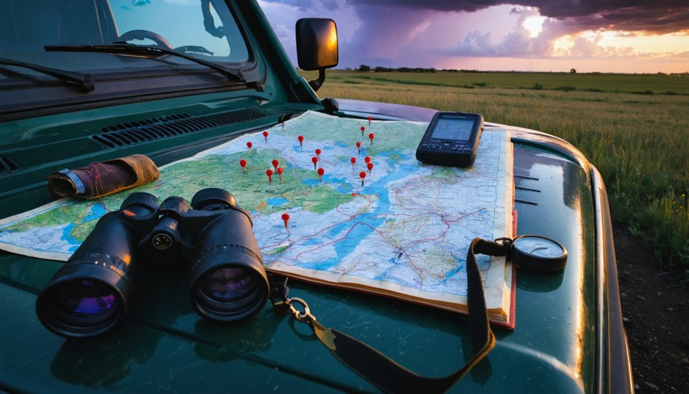
Safety Considerations and Chase Preparation
Before entering active storm environments, you’ll need vehicular redundancy in navigation systems (GPS with offline topographic maps), dual-band communication arrays (VHF radio, cellular hotspot, satellite messenger), and meteorological instrumentation calibrated to NOAA standards.
Vehicle preparation demands all-terrain capabilities, reinforced windshields, and emergency egress protocols.
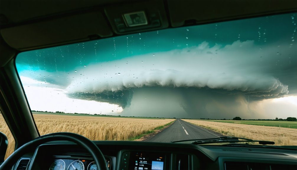
Weather forecasting requires analyzing mesoscale convective parameters: CAPE values exceeding 2000 J/kg, 0-6km bulk wind differential above 40 knots, and storm-relative helicity measurements. Monitor NEXRAD Level II data streams and velocity couplets indicating rotation. Maintain minimum two-mile separation from tornado circulation cores.
Document chase plans with specific waypoints and abort criteria. Your operational autonomy depends on systematic preparation—equipment redundancy eliminates single-point failures that compromise mission objectives and personal safety in dynamic severe weather scenarios.
Frequently Asked Questions
What Equipment Do I Need to Start Storm Chasing in Texas?
You’ll need essential storm chasing gear including real-time radar systems, GPS units, and weather monitoring devices like anemometers and barometers. Add reliable communication equipment, high-capacity power banks, and professional cameras to document meteorological phenomena independently.
Are There Guided Storm Chasing Tours Available in Texas?
You’ll find licensed storm chasing operators like Tempest Tours in Arlington offering guided storm chasing services throughout Texas. These outfitters provide meteorologist-led expeditions with real-time radar tracking, maintaining exemplary safety records while you pursue supercells across Tornado Alley.
How Do I Obtain Real-Time Tornado Warnings While Chasing?
You’ll obtain real-time tornado warnings by monitoring NWS radar through mobile weather app notifications like RadarScope and FEMA, accessing real-time weather data sources including NOAA Weather Radio, and following official @NWSFortWorth alerts during active chase operations.
What Insurance Coverage Do Storm Chasers Need in Texas?
You’ll need extensive liability insurance covering third-party property damage and bodily injury, plus collision coverage for your chase vehicle. Additionally, maintain documented vehicle maintenance requirements including brake inspections, tire conditions, and emergency equipment functionality for ideal storm pursuit operations.
Can Beginners Safely Chase Tornadoes Without Professional Training?
No, you shouldn’t chase without professional training. Beginner safety precautions require NOAA spotter certification, radar interpretation skills, and proper equipment. Start at designated tornado viewing locations for beginners with experienced guides to minimize Texas’s documented 124 annual injuries.