To improve meteorological data analysis, you can’t rely on a single radar feed or surface observation. Cross-verify radar returns against satellite imagery, validate ground sensor readings with upper-air data, and run outlier detection algorithms continuously. Use live radar feeds, hourly model updates, and RUC soundings to build a unified operational picture. Regular sensor calibration and disciplined filtering keep your field data clean and actionable. There’s a lot more to unpack if you want to sharpen every layer of your analysis.
Key Takeaways
- Cross-verify radar returns against satellite imagery and surface observations to confirm storm structure and avoid single-source misinterpretation.
- Monitor live radar feeds, hourly model updates, and hodographs to continuously refine real-time forecast accuracy.
- Run outlier detection algorithms and calibrate sensors regularly to maintain clean, reliable field data.
- Upload spotter reports and inflow measurements immediately to centralized platforms for NWP model integration.
- Cross-reference surface observations with upper-air data to validate environmental profiles and strengthen forecast confidence.
Why Most Storm Chasers Get Meteorological Data Wrong
Most storm chasers misinterpret meteorological data because they rely on a single data source instead of cross-verifying measurements across multiple independent systems.
Data misinterpretation often stems from trusting one radar feed or one surface observation without validating it against satellite imagery or upper-air soundings. You’re compounding that error when you ignore sensor malfunction warnings embedded in your equipment’s diagnostic outputs.
You need to implement outlier detection protocols that flag erroneous readings before they corrupt your analysis.
Calibrate your ground-based sensors regularly, and always cross-reference pressure and wind measurements against independent mobile weather stations.
When you skip verification steps, you’re not exercising freedom—you’re surrendering accuracy to avoidable error.
Precise, multi-source data validation is what separates disciplined chasers from those chasing the wrong storm entirely.
Which Real-Time Tools Actually Improve Storm Forecast Accuracy?
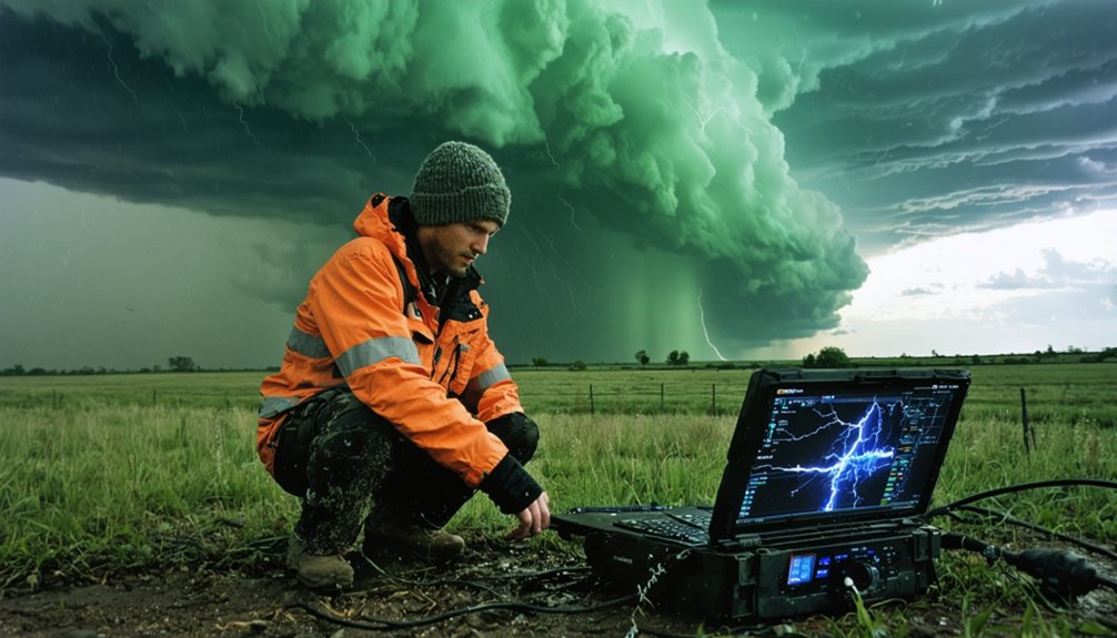
When you’re chasing severe weather, live radar feeds and hourly computer model updates are your highest-leverage tools for maintaining forecast accuracy. Doppler radar gives you direct wind speed and rotation data inside active thunderstorms, letting you make precise intercept decisions without guesswork.
Real-time collaboration with spotters and meteorologists through centralized mapping platforms strengthens your situational awareness considerably. You’re not operating on isolated data—you’re integrating surface observations, upper-air soundings, and mobile weather station readings into a unified operational picture.
Collaboration with spotters and meteorologists transforms isolated data points into a unified, actionable operational picture.
Data integration across radar, satellite, and numerical model outputs eliminates the blind spots that single-source analysis creates. Monitor RUC soundings and hodographs hourly to track cap erosion and shear evolution.
These combined tools don’t just improve forecasts—they give you the operational independence to act decisively.
How to Cross-Verify Radar, Satellite, and Ground Sensor Data?
Cross-verifying radar, satellite, and ground sensor data starts with validating radar returns against satellite imagery to confirm storm structure and intensity aren’t artifacts of beam overshooting or ground clutter.
Maintaining data consistency across platforms requires disciplined cross-referencing and routine sensor calibration.
Use these verification steps to keep your data reliable:
- Compare radar reflectivity with visible and infrared satellite loops to confirm cloud-top structure
- Run outlier detection algorithms to flag erroneous ground sensor readings automatically
- Calibrate ground-based sensors regularly to preserve accurate wind and pressure measurements
- Geo-tag all imagery with GPS coordinates to align observations spatially
- Cross-reference surface observations with upper-air data to validate environmental profiles
These steps eliminate conflicting data, sharpen your situational awareness, and keep your forecasting decisions grounded in verified, actionable intelligence.
How to Keep Your Meteorological Data Clean in the Field?
Keeping your meteorological data clean in the field demands disciplined filtering, consistent calibration, and real-time validation before errors compound across your dataset.
You’ll need to run outlier detection algorithms continuously, flagging readings that deviate beyond acceptable thresholds for immediate review. Sensor calibration isn’t optional—it’s a non-negotiable accuracy maintenance routine you perform before and during every deployment.
Environmental factors like dust, moisture, and temperature swings degrade sensor performance fast, so you’ve got to account for those conditions in your data cleaning workflow.
Mobile observations introduce additional noise, requiring stricter measurement verification protocols than fixed stations.
Cross-check your field techniques against independent sources, including nearby surface stations or radar returns, to confirm your readings hold up under scrutiny before uploading anything to shared databases.
Upload Spotter and Sensor Data to Sharpen Numerical Forecast Models
Clean field data only delivers its full value once it’s feeding into systems larger than your own dataset. Data integration with numerical weather prediction models drives real model enhancement, tightening forecast accuracy across broader regions.
Prioritize these actions during active chase operations:
- Upload spotter reports to centralized web-based mapping platforms immediately
- Share real-time inflow measurements directly with NWP model ingestion systems
- Collaborate with meteorologists to validate environmental data against model output
- Contribute storm imagery to crowdsourced research databases for mesoscale analysis
- Provide tornado proximity observations to refine vortex dynamic algorithms
Every data point you transmit strengthens the collective forecasting infrastructure.
You’re not just chasing storms—you’re actively expanding the scientific framework that predicts them.
Frequently Asked Questions
How Do Historical Skew-T Diagrams Improve CAPE and Buoyancy Analysis Accuracy?
By analyzing historical trends in Skew-T diagrams, you’ll sharpen your CAPE and buoyancy assessments, recognizing recurring atmospheric stability patterns that refine your predictive algorithms, giving you precise, data-driven insights to chase storms more effectively and independently.
What Buffer Zone Distance Keeps Storm Chasers Safest Near Predicted Storm Locations?
Keep your distance — maintain a 20–30 mile buffer zone east of predicted storm locations. You’ll optimize safety protocols by integrating distance estimation into chase routes, ensuring storm tracking data guides your positioning without compromising operational freedom.
How Often Should Ground-Based Sensors Be Recalibrated During Active Chase Seasons?
You should recalibrate ground-based sensors monthly during active chase seasons, though sensor drift, environmental factors, and seasonal variations may demand higher recalibration frequency. Extreme heat, humidity, and vibration accelerate drift, so you’ll want to prioritize data integrity relentlessly.
Which Camera Framing Techniques Best Capture Ground-Level Tornado Activity Clearly?
Set your camera angles so the lower 20% captures ground-level activity. You’ll maximize tornado tracking accuracy and storm visibility using wide-angle lenses on tripods, ensuring framing techniques document vortex dynamics with precision and scientific clarity.
How Do Hodograph Analyses Help Determine Atmospheric Cap Strength Before Chasing?
Ironically, hodograph interpretation won’t chase storms for you, but it’ll keep you alive. You’ll analyze wind shear profiles, assess atmospheric stability, gauge cap strength precisely, and make data-driven decisions that maximize chaser safety before committing to any intercept.
References
- https://www.pbs.org/newshour/show/how-storm-chasers-and-meteorologists-are-working-together-to-improve-tornado-forecasts
- https://crazystormchasers.com/quality-control-in-meteorological-data-analysis-for-storm-chasers/
- https://www.stormchasingusa.com/blog/learning-the-basics-about-tornadic-storm-forecasting/
- https://www.weatheradar.com/article/into-the-vortex-the-high-stakes-world-of-storm-chasing-a14
- https://el-reno-survey.net/data-collection-recommendations/
- https://journals.ametsoc.org/view/journals/bams/97/11/bams-d-15-00174.1.xml
- https://www.youtube.com/watch?v=rhI__lS3nEo
- https://stormhorn.com/storm-chasing/educational-research/
- https://stormchasing.us/projects/cps_outline.pdf
- https://stormtrack.org/threads/new-chasing-method-critiques-and-rebukes-wanted.15737/


