Improving storm interception starts with replacing static forecasting models with AI-driven tools that process real-time atmospheric data. You’ll gain sharper positioning accuracy by integrating live radar, lightning feeds, and machine learning models like Aurora, which reduces 5-day Atlantic tropical cyclone track errors by 20-25%. High-frequency data cycling and neural network bias correction tighten short-term storm evolution metrics. The techniques and tools that field chasers actually rely on go much deeper than that.
Key Takeaways
- AI models like Aurora reduce Atlantic tropical cyclone track errors by 20-25%, improving storm interception positioning and expanding operational decision-making windows.
- Integrating live radar and lightning data enables real-time detection of shifting storm patterns before full development occurs.
- High-frequency 10-minute data cycling sharpens storm metrics, improving tracking of intensity changes and landfall frequency predictions.
- Vertical 3D radar profiling differentiates shallow from deep convective cores, enhancing storm structure interpretation and reducing dangerous misreadings.
- Lightning flash rate acceleration and jump detection serve as reliable indicators of rapid updraft strengthening and severe weather potential.
Why Traditional Storm Interception Methods Keep Failing Chasers
Traditional storm interception methods fail chasers because they rely on static forecasting models that can’t adapt to rapid atmospheric changes in real time.
You’re working with outdated positional data, fixed model outputs, and limited radar integration that creates dangerous blind spots. These traditional methods’ shortcomings become critical when storms accelerate, shift tracks unexpectedly, or intensify beyond projected thresholds.
Storm interception challenges compound further because conventional approaches lack high-frequency data cycling, the same 10-minute assimilation intervals that modern systems use to capture short-term storm evolution.
Without high-frequency data cycling, conventional methods miss the rapid storm evolution that decides every interception.
Without structure-based detection algorithms or recurrent neural network bias correction, you’re fundamentally maneuvering through dynamic meteorological events using yesterday’s analytical framework.
That disconnect between atmospheric reality and your data inputs costs you positioning accuracy, situational awareness, and ultimately, successful interceptions.
How AI Models Like Aurora Sharpen Storm Track Predictions
When you’re chasing storms, every mile of track error costs you a successful intercept. Aurora’s machine learning architecture is cutting Atlantic tropical cyclone track errors by 20-25% in 5-day forecasts, outperforming seven major global forecast centers.
You can apply that same AI-driven precision to eastern Pacific systems, where fine-tuned Aurora models achieve an average 20% reduction in track error across tested storms.
Models like TC-GEN further sharpen your situational awareness by using recurrent neural networks to blend synthetic TC seeds with environmental data, accurately capturing track density, landfall frequency, and intensity metrics that traditional methods consistently miss.
Aurora’s Track Error Reduction
Cutting through the noise of conventional forecasting, the Aurora AI model sharpens Atlantic tropical cyclone track predictions by reducing 5-day forecast errors by 20–25%, outperforming seven major global forecasting centers (Bodner et al., 2025, *Nature*).
You’re working with a system that doesn’t just marginally improve—it systematically redefines forecasting precision at scale.
When fine-tuned for eastern Pacific conditions, Aurora maintains an average track error reduction of 20%, demonstrating consistent cross-basin reliability.
That consistency matters when you’re making interception decisions under pressure. Aurora processes atmospheric data with a rigor that legacy models can’t match, translating raw environmental inputs into tighter, more actionable storm track projections.
For storm chasers demanding accurate positioning data, Aurora’s error reduction directly increases your operational window and reduces unnecessary risk exposure.
Machine Learning Storm Modeling
Machine learning storm modeling works by ingesting massive atmospheric datasets and identifying nonlinear patterns that deterministic physics-based models consistently miss.
You’re now working with tools that don’t just react to atmospheric conditions—they anticipate them.
TC-GEN exemplifies this shift, generating synthetic cyclones through data-driven seed creation and seamless data blending with surrounding environmental fields.
Recurrent neural networks then correct intensity biases, producing simulations that accurately replicate track density, landfall frequency, and outermost wind extents.
Aurora operates similarly, reducing five-day Atlantic track errors by 20-25% while outperforming seven major global forecasting centers.
These aren’t marginal gains—they’re structural improvements that expand your operational decision-making window.
When models capture what physics-based systems miss, you intercept storms with greater precision and fewer dangerous surprises.
AI Forecast Accuracy Gains
Aurora’s accuracy gains don’t just validate machine learning’s role in storm modeling—they quantify it. Across 5-day Atlantic forecasts, Aurora reduces tropical cyclone track errors by 20–25%, outperforming seven major global centers.
You’re working with AI prediction enhancements that deliver measurable, reproducible results—not theoretical improvements.
Data integration strategies combining radar, satellite feeds, and GLM lightning analysis techniques sharpen short-term convective forecasts through high-frequency 10-minute cycling.
These inputs feed advanced storm metrics that track intensity, landfall frequency, and wind extent with precision statistical models can’t match.
For risk management forecasting, this matters operationally. You can intercept storms with greater confidence when track uncertainty shrinks.
Aurora’s eastern Pacific tests confirm a consistent 20% error reduction—giving you actionable precision when positioning decisions carry real consequences.
Why Live Radar and Lightning Data Make Storm Forecasts More Accurate
When forecasters integrate live radar and lightning data into storm prediction models, they dramatically sharpen short-term accuracy in ways that static or delayed datasets simply can’t match.
Real time data feeds directly into predictive analytics engines, allowing models to detect shifting storm patterns before they fully develop. Radar technology captures three-dimensional storm dynamics at resolutions that reveal structural changes within minutes.
Real-time radar doesn’t just track storms—it reveals how they’re transforming, minute by minute, before disaster strikes.
Meanwhile, lightning strikes serve as critical convective indicators—sudden increases in strike frequency often signal rapid intensification.
Data integration through systems like 3DVAR with GLM Lightning Mapper has demonstrated measurable gains in event forecasting, improving both rainfall accumulation predictions and radar reflectivity outputs.
High-frequency 10-minute cycling further refines short-term storm evolution accuracy. You’re not guessing—you’re leveraging real physics translated into actionable, precise forecast intelligence.
Reading Radar and Lightning Data Like a Pro

When you analyze radar reflectivity patterns, you’re interpreting dBZ values that reveal precipitation intensity, storm structure, and rotation signatures critical for accurate interception decisions.
High-reflectivity cores exceeding 65 dBZ often indicate hail, while hook echoes and bounded weak echo regions signal strong updrafts and mesocyclone development.
Pairing these radar signatures with lightning data—particularly rapid increases in total flash rate, known as lightning jumps—gives you a sharper, more quantifiable picture of storm intensification in real time.
Decoding Radar Reflectivity Patterns
Radar reflectivity data gives you a direct window into storm structure, intensity, and potential hazards—but only if you know how to read it. High dBZ values signal dense precipitation cores, while sharp reflectivity trends along storm edges indicate rapid intensification or collapse.
You’ll want to track radar signatures like hook echoes, bow echoes, and bounded weak echo regions—each revealing distinct threat profiles.
Structure-based detection methods outperform velocity gradient approaches when identifying tornadoes, hail, and damaging winds. By analyzing 3D gridded reflectivity patterns, you can differentiate transient features from sustained hazards, sharpening your interception decisions.
Monitor reflectivity trends across multiple elevation scans, not just the base scan, to capture the full vertical storm profile and avoid misreading shallow versus deep convective cores.
Lightning Data Interpretation Techniques
Beyond reflectivity patterns, lightning data adds another diagnostic layer that sharpens your situational awareness during storm interception. Modern lightning detection systems, like NOAA’s Geostationary Lightning Mapper, deliver real-time strike data that reveals storm intensification trends before radar confirms them.
Integrate lightning data into your workflow using these key interpretation techniques:
- Flash rate acceleration: A rapid increase in total lightning signals updraft strengthening, often preceding severe weather by minutes.
- Jump detection: A lightning jump—sudden flash rate doubling—indicates imminent tornado or hail potential.
- Data visualization overlays: Mapping strike density against radar reflectivity exposes structural asymmetries invisible to reflectivity alone.
Combining 3DVAR assimilation methods with GLM lightning data, as validated by AMS research, improves your short-term storm evolution assessments, giving you a decisive operational edge.
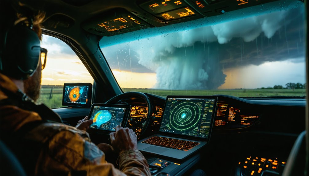
The Storm Tracking Apps Field Chasers Actually Rely On
Field chasers don’t rely on a single app—they stack tools that serve distinct analytical functions, from real-time radar interrogation to mesoscale surface analysis. Your toolkit determines your situational awareness ceiling.
Storm chaser apps like RadarScope deliver dual-pol radar products—correlation coefficient, differential reflectivity—that let you identify debris signatures and hail cores independently. GREarth layers surface observations over terrain, sharpening your mesoscale boundary analysis.
Spotter Network positions you within the broader ground-truth network, feeding real-time location data to NWS meteorologists.
These data analysis tools aren’t passive displays—they’re decision frameworks. You’re cross-referencing hodographs from SPC’s mesoanalysis page against observed storm motion, then validating with high-resolution RAP soundings.
Stack these platforms deliberately, prioritize overlapping data confirmation, and you’ll intercept with precision rather than luck.
How AI-Generated Storm Tracks Help You Plan Safer Intercepts
When AI-generated storm tracks enter your planning workflow, your intercept decisions shift from reactive to predictive. Models like Aurora reduce 5-day Atlantic track errors by 20-25%, giving you actionable storm prediction windows before conditions develop.
Data integration across radar, satellite, and lightning sources sharpens that advantage further.
Data integration across radar, satellite, and lightning sources doesn’t just add context — it compounds your decision-making advantage.
Use AI-driven track outputs to:
- Identify ideal intercept corridors by analyzing projected track density and landfall probability zones
- Anticipate intensity shifts using bias-corrected recurrent neural network outputs that flag rapid intensification windows
- Refine your positioning timeline against 10-minute cycling forecast updates during active storm evolution
You’re no longer guessing direction from visual cues alone.
You’re operating from quantified probability fields, which means smarter routing, reduced exposure risk, and intercepts executed on your terms.
Making Safer Intercept Calls With Advanced Storm Data
Smarter storm tracks get you into position, but converting that positional advantage into a safe intercept call demands a second layer of judgment grounded in real-time data synthesis.
Structure-based detection algorithms now outperform velocity gradient methods, giving you sharper storm dynamics identification across tornado, hail, and wind hazards.
You’ll integrate real time monitoring feeds—radar reflectivity, GLM lightning data, and 3D gridded analyses—into your decision making tools, filtering transient features from genuine threats.
Predictive modeling narrows your risk assessment window, letting chaser strategies pivot as storm interception angles shift.
Neighborhood-based verification metrics validate your rainfall and reflectivity reads before you commit to a route.
Layering these interception techniques atop proven data analysis frameworks keeps your safety measures intact while preserving the autonomy that defines purposeful storm chasing.
Frequently Asked Questions
How Does Storm Chasing History Influence Modern Data Analysis Tool Development?
Storm chasing’s historical techniques directly shaped data evolution, pushing you toward smarter tools. You’ve inherited field-tested methods that drove AI models, radar integration, and structure-based detection systems revolutionizing how you intercept and analyze modern storms.
What Government Agencies Fund Advanced Storm Interception Technology Research Programs?
You’ll find NOAA and NSF drive federal funding for advanced storm interception research partnerships, collaborating with universities and private sectors to accelerate data-driven forecasting innovations, empowering you with cutting-edge meteorological tools and technologies.
Can Storm Interception Data Contribute to Long-Term Climate Change Research Findings?
Yes, you’re literally reshaping climate models forever! Your storm interception data skyrockets data accuracy, revealing long-term trends and refining research methodologies, empowering you to challenge conventional boundaries
How Do Storm Chasers Legally Access Restricted Severe Weather Observation Zones Safely?
You’ll access restricted severe weather zones by securing legal permits from local authorities and adhering to strict safety protocols, including real-time data monitoring, coordinated communication systems, and structured risk assessments that empower your autonomous, informed decision-making in dynamic field conditions.
What Physical Fitness Requirements Exist for Professional Storm Interception Field Work?
You’ll need strong endurance training to withstand prolonged field exposure and rapid repositioning demands. Mastering equipment handling guarantees you’re operationally efficient under pressure, as physical resilience directly correlates with successful, data-driven storm interception performance metrics.
References
- https://research.noaa.gov/three-ways-noaa-research-works-to-improve-our-weather-forecasts/
- https://www.mdpi.com/2072-4292/15/1/119
- https://www.youtube.com/watch?v=lL8yINOXrfQ
- https://pratus.disastertech.com/blog/improving-hurricane-track-prediction-ai
- https://crazystormchasers.com/enhancing-storm-tracking-accuracy-with-data-analysis/
- https://crazystormchasers.com/advanced-techniques-for-storm-chasers-data-analysis/
- https://texmex.mit.edu/pub/emanuel/PAPERS/Jing_etal_2024.pdf
- https://journals.ametsoc.org/view/journals/mwre/147/11/mwr-d-18-0421.1.pdf
- https://ams.confex.com/ams/pdfpapers/97162.pdf


