You’ll maximize storm intercept effectiveness by deploying solid-state ultrasonic anemometers that survive 50+ m/s winds, integrating fixed-wing drones for 180-minute penetration missions up to 15,000 feet, and upgrading to 5.7K 360° cameras with 4-6 hour runtimes. Implement multi-SIM connectivity across 540+ networks to maintain telemetry during infrastructure degradation, and attend professional forecasting summits to shift from computational reliance to mesoscale pattern recognition. These integrated deployments capture sub-second atmospheric shifts that standard configurations miss entirely.
Key Takeaways
- Deploy ultrasonic wind sensors on mobile platforms to capture extreme wind data beyond 50 m/s without mechanical failure.
- Utilize fixed-wing drones for extended storm penetration, accessing boundary layer data from 50 to 15,000 feet aerially.
- Install 360° camera systems with 4-6 hour battery life to document complete mesocyclone evolution at high resolution.
- Implement multi-SIM connectivity across 540+ networks to maintain uninterrupted data transmission during remote intercepts.
- Attend professional forecasting summits to master synoptic-scale pattern recognition and real-time observational analysis techniques.
Deploy Ultrasonic Wind Sensors for Extreme Condition Durability
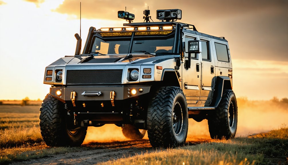
When storm chasers position their vehicles directly in the path of violent convective systems, sensor durability becomes non-negotiable. You’ll need ultrasonic wind sensors that eliminate mechanical vulnerabilities through solid-state construction. These transducer arrays measure wind speed and direction via time-of-flight pulse analysis, surviving beyond 50m/s conditions—validated at 51.5m/s during the June 5, 2025 Morton, Texas tornado intercept. Their no-moving-parts design resists hail impact, debris strikes, and extreme turbulence that destroy propeller anemometers.
For mobile integration on mesonet platforms like SCOUT1, mount sensors on custom aluminum racks that maintain structural integrity during high-speed deployments. Real-time data acquisition enables predictive analytics in near-surface wind fields. You’ll achieve consistent measurements throughout convective lifecycles while minimizing field maintenance requirements—critical when operating from remote headquarters across multiple campaign deployments. The Japan Meteorological Agency has certified these sensors up to 90m/s operational limits with survivability testing extending to 108m/s. The modular rack design facilitates seamless sensor transfer between vehicle platforms, supporting scalable deployment strategies as operational requirements evolve.
Integrate Fixed-Wing Drones for Extended Storm Penetration
Because traditional multirotor platforms exhaust battery reserves within 30-40 minutes, you’ll need fixed-wing drones that leverage aerodynamic lift to achieve 180-minute operational windows during storm penetration missions. Their 2.6-pound airframes withstand 228 mph hurricane winds while maintaining 169-nautical-mile radio links—proven during NOAA’s eyewall deployments from P-3 Orion aircraft.
You’ll gain access to boundary layer data from 50 to 15,000 feet without infrastructure constraints, thanks to VTOL capability eliminating runway dependencies at remote chase sites. Onboard RTK/PPK GNSS enables sensor fusion techniques that merge atmospheric readings with precise positioning during turbulence. Machine learning algorithms can generate adversarial wind profiles that train your flight controllers to handle unpredictable gusts and microbursts encountered during active storm chasing.
Real-time data processing through dual-link communication delivers actionable intelligence across 100 km ranges, letting you document supercell evolution across 950,000 square kilometers—unmatched operational freedom for severe weather documentation. The modular aircraft design incorporates SwiftCore automation that enhances resilience during extreme weather deployments and streamlines post-mission data workflows.
Upgrade to 360° Camera Systems With Extended Battery Life
Traditional single-perspective camera configurations force you to choose between documenting wall cloud development or capturing rear-flank downdraft interaction—a limitation eliminated by 360-degree systems that record complete hemispheric coverage at 5.7K resolution. You’ll capture rotation signatures simultaneously with mesocyclone evolution without repositioning your vehicle during critical moments.
Roof-mounted systems integrate directly with your OBS streaming infrastructure, transmitting live footage through dual-carrier hotspots enhanced by magnetic antenna signal boosters. Extended battery configurations enable 4-6 hour continuous operation during severe weather intercepts. Stream deck controls allow you to adjust pan and tilt remotely while maintaining focus on storm observation rather than manual camera operation.
Pair your 360 camera with thermal camera attachments to document temperature gradients within inflow bands, while microclimate analysis instruments validate pressure differential measurements. Install a mobile weather station on your roof rack to feed real-time atmospheric data directly into your command center for synchronized meteorological analysis. This configuration eliminates missed documentation when tornadic development occurs in unexpected vectors, delivering broadcast-quality footage from every azimuth simultaneously.
Implement Multi-SIM Connectivity Solutions for Remote Data Transmission
During extended deployments across rural Great Plains corridors, your data transmission infrastructure faces cellular dead zones that compromise real-time telemetry upload—a critical failure point when transmitting Doppler velocity data, atmospheric pressure readings, and live storm footage to research teams and broadcast networks.
Multi-IMSI SIM cards maximize carrier flexibility by connecting across 540+ cellular networks in remote territories. When your primary carrier signal degrades during mesocyclone intercepts, on-SIM intelligence automatically switches to alternative networks—eliminating manual troubleshooting during time-sensitive pursuits. This automatic switching between carriers maintains stronger signal strength and minimizes connectivity loss during critical storm documentation phases.
These solutions guarantee redundant network access through pre-loaded profiles spanning multiple mobile operators. You’ll maintain continuous 4G/LTE connectivity for high-resolution video streams while avoiding roaming fees and managing deployments through unified APIs. Single-SKU implementation streamlines vehicle installations, letting you focus on meteorological objectives rather than connectivity troubleshooting. For bidirectional communications with command centers, SIM2SIM capability enables direct device-to-device connections without complex system integration.
Attend Professional Summits to Learn Advanced Forecasting Parameters
Strategic immersion in meteorological conferences accelerates your mastery of synoptic-scale pattern recognition and mesoscale forecasting parameters that separate successful intercepts from failed deployments. Events like Denver’s National Storm Chaser Summit and TESSA’s Arlington conference deliver direct access to operational forecasters and researchers who’ll demonstrate how to analyze leading weather models through numerical processes displaying wind shear, moisture transport, and instability indices.
You’ll learn the critical shift from overnight model analysis to morning deployment decisions when you prioritize real time observations from NWS radiosondes and radar returns over computational predictions. Expert sessions reveal which atmospheric ingredients demand attention across multiple initialization runs. Professional tour companies maintain equipment reliability through continuous testing and maintenance, ensuring their forecasting technology performs flawlessly during critical decision windows. The summit environment also fosters camaraderie and friendship among the stormchasing community as participants share knowledge and experiences. Free access to Texas events and networking opportunities at sponsored summits eliminate barriers to acquiring forecasting methodologies that maximize your intercepting autonomy while minimizing wasted chase days.
Frequently Asked Questions
How Do Lightning Protection Drones Capture Energy for Renewable Use?
Though power generation capabilities aren’t yet operational, you’ll see future systems using charging devices to capture lightning’s 400 kWh. Current prototypes redirect strikes safely while researchers develop energy storage solutions to harness this untapped atmospheric resource.
What FPV Drone Specifications Work Best for Hurricane Eyewall Chasing?
You’ll need 5-7 inch quads with 235+ mph wind tolerance, reinforced airframes, and prop guards. Prioritize flight endurance exceeding 20 minutes, high camera resolution for eyewall documentation, and sensors capturing pressure, temperature, and humidity data at violent-wind altitudes.
Can Rotary Drones Carry Ultrasonic Wind Sensors During Tornado Intercepts?
Yes, rotary drone capabilities enable ultrasonic sensor deployment during tornado intercepts. You’ll achieve wind measurement precision by mounting sensors 4.8+ meters upstream or using sling-load configurations below the aircraft, minimizing propeller-induced flow distortion in extreme vortex conditions.
How Does LIQ Technology Compare to Traditional Cellular Boosters for Transmission?
LIQ’s 100 dB gain delivers 3000x more amplification than traditional 70 dB boosters, dramatically improving your signal strength reliability and data transmission stability. You’ll experience carrier-specific optimization through machine learning, ensuring superior uplink power and coverage when you need autonomy most.
What Mounting Modifications Transfer Mesonet Equipment Between Different Vehicle Platforms?
You’ll find permanent installations don’t transfer between platforms—customized mounting solutions require complete reinstallation at $17,500 per garage setup. Vehicle mounting brackets remain platform-specific, though modular sensor arrays can rotate during scheduled maintenance without structural modifications.
References
- https://www.meteorologicaltechnologyinternational.com/news/weather-instruments/ft-technologies-wind-sensor-deployed-in-storm-chasing-research.html
- https://www.eurekalert.org/news-releases/1051404
- https://www.global.ntt/insights-hub/storm-chasing-drones-to-capture-lightning/
- https://stormtrack.org/threads/what-will-you-add-change-to-your-chasing-in-2026.33258/
- https://www.youtube.com/watch?v=ppBCmk-LGqQ
- https://www.youtube.com/watch?v=uInuI3qVkr0
- https://www.youtube.com/watch?v=u6lC8MgCsII
- https://fttechnologies.com/case-study/extreme-wind-measurement-storm-chasing-mesonet
- https://www.codasensor.com/ultrasonic-vs-mechanical-wind-sensors.html
- https://www.youngusa.com/lp/wind-sensors/