To avoid the bear’s cage, you must treat the hook echo’s precipitation wrap as a hard boundary and never position inside it. Use radar velocity data to identify tight rotational couplings, and watch for horizon darkening and audible hail as immediate exit triggers. Escape perpendicular to storm movement — east or southeast — before visibility drops below 100 yards. Every second of delayed action eliminates your freedom to maneuver safely, and there’s far more to understand about surviving these conditions.
Key Takeaways
- The bear’s cage is a rain-wrapped zone around a supercell’s mesocyclone where tornadoes can strike before becoming visible.
- Use radar hook-echo signatures and velocity data showing rotational coupling to identify and avoid the bear’s cage boundary.
- Position yourself in the storm’s southeast quadrant to maintain mesocyclone visibility while keeping safe distance from precipitation wraps.
- Exit perpendicular to storm movement, heading east or southeast, before visibility drops below 100 yards or hail size increases.
- Act immediately when visual indicators appear, as delayed escape decisions eliminate safe movement options in deteriorating conditions.
What Is a Bear’s Cage in Storm Chasing?
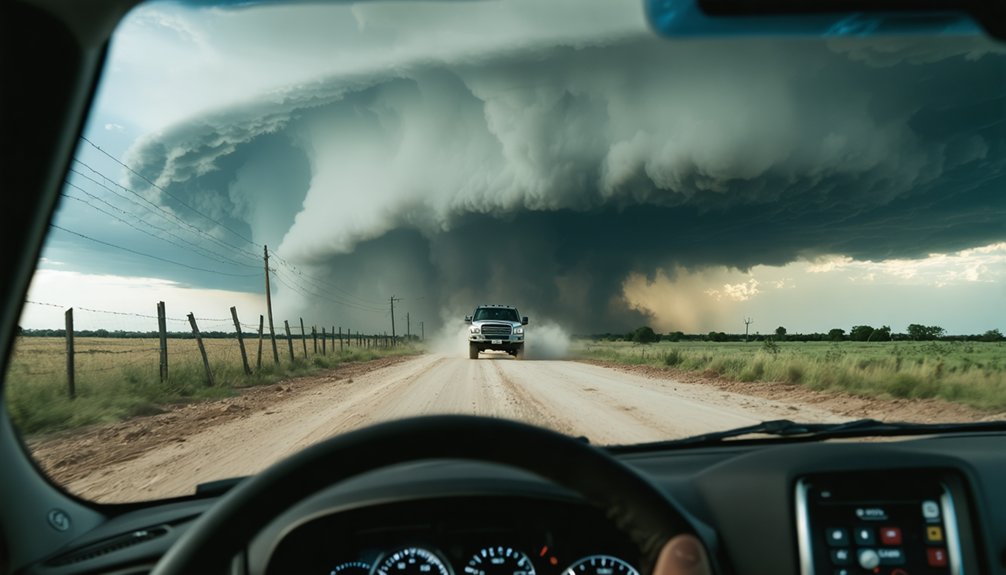
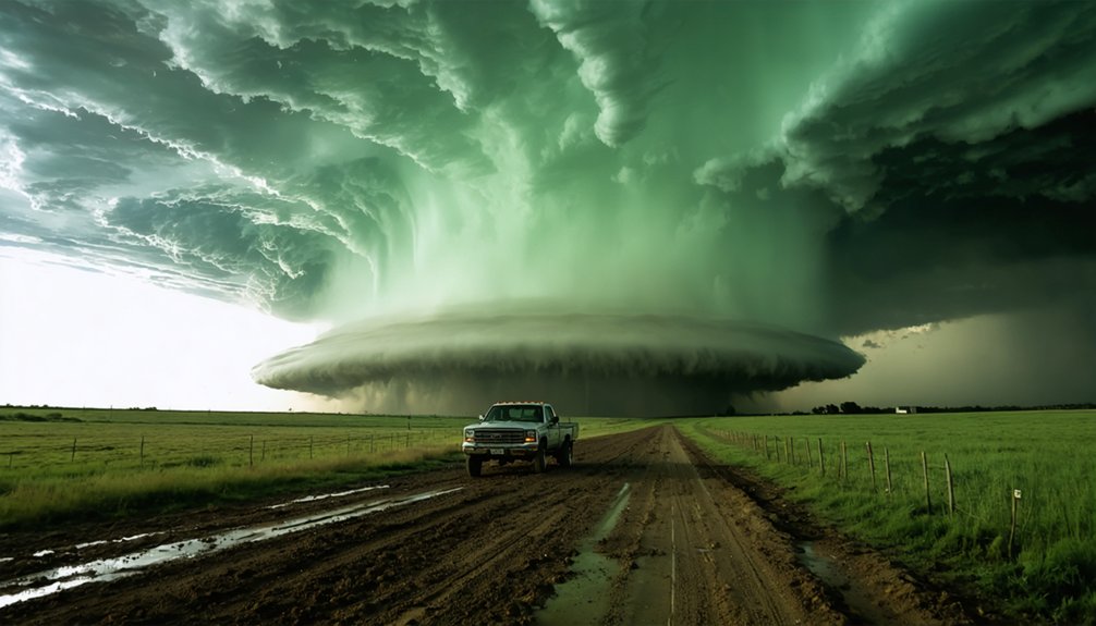
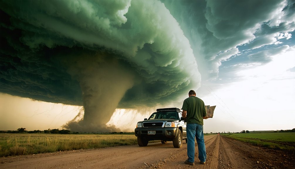
In storm chasing, the “bear’s cage” refers to the area of heavy precipitation — rain or hail — that wraps around a supercell’s mesocyclone, forming a dangerous curtain that obscures the rotating updraft beneath it.
You’ll find it on the southern and western flanks of the mesocyclone, coinciding precisely with the radar hook-echo signature.
It’s a slang term that captures a critical storm observation challenge: a tornado can be actively producing damage inside that rain curtain while remaining completely invisible from a safe distance.
This severely compromises tornado detection, since you can’t visually confirm rotation without penetrating the precipitation core.
The bear metaphor isn’t casual — it signals a concealed, lethal threat.
Understanding this structure is fundamental before you ever position yourself near a supercell.
Why Rain-Wrapped Tornadoes Inside the Bear’s Cage Kill Without Warning
Unlike visible tornadoes, rain-wrapped systems eliminate your reaction window entirely.
Standard visibility management techniques — maintaining lateral distance, reading debris clouds, tracking funnel formation — fail completely when a curtain of hail and rain blocks every sightline.
Radar shows rotation. Your eyes show nothing.
That gap between what instruments detect and what you can physically observe is precisely where fatalities occur.
You’re making escape decisions with incomplete data, compromised visibility, and a tornado that’s already within lethal range before you’ve confirmed its position.
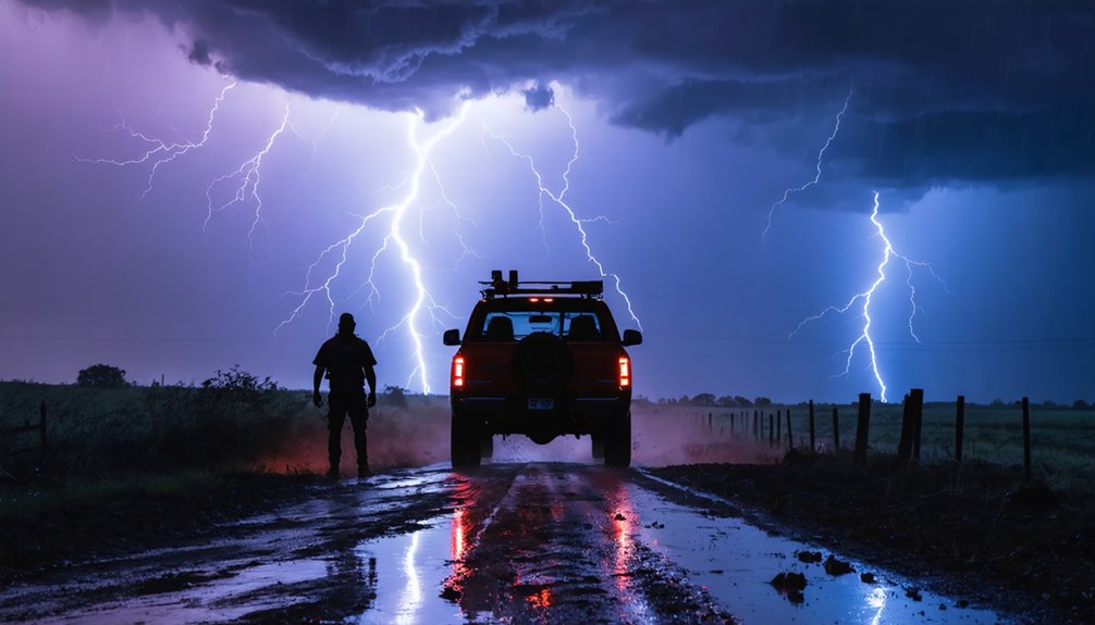
Hail, Lightning, and Flooding Inside the Bear’s Cage
Tornadoes aren’t the only threat waiting inside the bear’s cage. Hail damage alone can shatter windshields, dent vehicles, and incapacitate your escape route within seconds.
Large-core hail frequently accompanies the hook echo’s precipitation wrap, leaving you with no viable exit. Lightning safety becomes equally critical—cloud-to-ground strikes concentrate heavily around the rotating updraft, targeting anyone stationary in open terrain. You’re fundamentally standing inside an electrical kill zone.
Flooding risks compound these hazards rapidly; the intense rainfall saturating roads can make familiar escape routes impassable without warning. Storm preparedness demands you treat each threat as simultaneously lethal, not sequentially.
Experienced chasers respect that the bear’s cage packages multiple independent kill mechanisms together, and entering it means confronting all of them at once.
How to Spot a Bear’s Cage on Radar Before You’re Inside One
When scanning radar, you’ll want to identify the classic hook-echo signature — a curved appendage extending from the southern or southwestern flank of a supercell’s main precipitation core, indicating inflow wrapping cyclonically around the mesocyclone.
You should also examine velocity data for strong rotational couplings, specifically looking for tight, co-located areas of inbound and outbound velocities that confirm an active mesocyclone embedded within that precipitation wrap.
Once you’ve spotted both signatures together, treat that entire hook region as a bear’s cage and calculate your position relative to it before the rain curtain closes around you.
Identifying Hook-Echo Signatures
Spotting a bear’s cage on radar before you’re inside one starts with recognizing the hook-echo signature—a curved appendage extending from the southern or southwestern edge of a supercell’s main precipitation core.
Hook echo features appear as a distinct comma or fishhook shape on reflectivity scans, indicating precipitation wrapping around a mesocyclone. Radar interpretation becomes critical here: high reflectivity values within the hook suggest hail or intense rain, while the inflow notch—a relative clear area adjacent to the hook—marks where the updraft is drawing in surface air.
You’ll want to cross-reference velocity products alongside reflectivity, confirming rotational couplets near the hook’s tip. That convergence zone is precisely where a rain-wrapped tornado can exist, completely invisible from any exterior vantage point.
Reading Radar Rotation Indicators
Beyond reflectivity alone, velocity data gives you the clearest early warning that a bear’s cage is forming around a circulation. Through proper radar interpretation, you’ll identify the critical couplet signature: adjacent pixels displaying opposing velocities, one moving toward your radar site, one moving away. That tight pairing signals active rotation detection before precipitation fully wraps the updraft.
Watch for inbound velocities exceeding 50 knots adjacent to outbound velocities of similar magnitude. Tighter couplet spacing indicates stronger, more concentrated rotation. When that couplet aligns directly beneath your reflectivity hook, the bear’s cage is structurally developing.
Cross-reference your base velocity with storm-relative motion products to eliminate wind contamination. If rotation tightens while reflectivity wraps further southwest, you’re losing your escape window fast.
Visual Signs a Bear’s Cage Is Forming Around Your Position
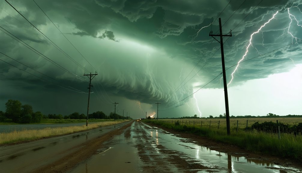
When darkening rain curtains begin closing in from multiple directions, you’re likely watching a bear’s cage form around your position.
If hail suddenly intensifies or shifts in bearing without warning, the storm’s precipitation core is encroaching on your location, signaling that the hook echo is tightening.
You’ll know visibility has become critically compromised when landmarks or road markers vanish within seconds, leaving you effectively blind to any rain-wrapped tornado that may be rotating nearby.
Darkening Rain Curtains Ahead
One of the earliest visual indicators that a bear’s cage is forming around your position is the progressive darkening and thickening of rain curtains across your field of view.
These dark cloud formations shift from translucent gray to near-opaque walls, signaling dangerous heavy rain patterns closing in.
Watch specifically for:
- Curtain opacity increase – Rain bands shifting from light gray to charcoal black indicate intensifying precipitation wrapping the mesocyclone.
- Narrowing visual corridors – Your available sight lines compress as precipitation encircles your position from multiple directions simultaneously.
- Ground-level darkness – When curtains obscure the horizon at surface level, visibility to potential tornadoes drops critically low.
Don’t wait for complete encirclement. Reposition immediately when curtains begin darkening on your southern or western flanks.
Sudden Hail Core Encroachment
Darkening rain curtains warn you visually, but hail core encroachment often signals the bear’s cage formation through sound and impact before your eyes can register the threat.
Sudden encroachment begins audibly—small stones striking your vehicle escalate rapidly into damaging golf ball–sized hail within seconds. That acoustic escalation confirms the precipitation core is wrapping your position.
Monitor radar continuously. When the hook-echo’s hail signature tightens around your GPS position, you’ve lost your escape window.
Hail safety demands immediate directional awareness: southeast movement typically exits the encircling core fastest, though local storm motion dictates your precise escape vector.
Don’t wait for visual confirmation. By the time you see the full curtain surrounding you, the rain-wrapped tornado inside the bear’s cage may already be within lethal striking distance.
Rapidly Reduced Visibility Signs
Visibility collapse happens fast—often faster than radar updates can reflect your worsening position. When precipitation begins wrapping your location, you’re already inside the bear’s cage formation sequence. Chaser awareness at this stage determines survival.
Watch for these immediate visual indicators:
- Horizon darkening on multiple sides simultaneously — rain curtains closing from two or more directions signal encirclement
- Contrast loss between cloud base and precipitation — when definition disappears, visibility loss is accelerating rapidly
- Hail beginning mid-observation — unexpected hail onset confirms you’ve entered the core without realizing it
Each indicator compounds the next. Once all three appear together, exiting becomes exponentially harder.
Don’t negotiate with deteriorating conditions—move immediately toward your pre-planned escape route before the curtain fully closes around your position.
How Experienced Chasers Position Themselves Around the Bear’s Cage
Experienced chasers treat the bear’s cage as a hard boundary, positioning themselves to maintain visual contact with the mesocyclone without breaching the precipitation curtain. Your chaser positioning should prioritize the storm’s southeast quadrant, where clear slots frequently develop and forward visibility remains viable.
Position yourself in the southeast quadrant — where clear slots open and the mesocyclone stays visible without crossing the bear’s cage.
From this angle, you’re reading the hook echo’s evolution in real time while keeping escape routes open to the south and east.
Never let the rain curtain close around your flanks. If you notice precipitation wrapping behind your position, execute a tactical retreat immediately — southbound, then east. Waiting compromises your exit.
Experienced chasers also cross-reference mobile radar overlays with visual cues, verifying that rotation isn’t tightening before committing to any closer approach. Your positioning discipline is what separates smart chasing from fatal mistakes.
When to Escape the Bear’s Cage Before It Closes
Timing your escape from the bear’s cage isn’t reactive — it’s anticipatory. Once precipitation begins wrapping your position, your escaping strategies must already be executing. Delayed decisions eliminate your freedom of movement entirely.
Watch for these critical triggers demanding immediate exit:
- Hook tightening on radar: Rotation intensifying means the curtain’s closing faster than you can navigate out.
- Visibility dropping below 100 yards: Your visibility tactics become useless when rain and hail fully obscure surrounding terrain.
- Hail size increasing suddenly: Larger stones signal you’re entering the core, cutting off clean escape routes.
Your exit path must always run perpendicular to storm movement — typically east or southeast. Never retreat directly south. Commit to your route before conditions force a panicked, reactive response that costs you control.
Frequently Asked Questions
Can a Bear’s Cage Dissipate Quickly Enough to Become Suddenly Safe?
No, a bear’s cage rarely dissipates quickly enough to become suddenly safe. You can’t trust unpredictable storm patterns; bear behavior mirrors this—it’s erratic. Always prioritize safety measures, as these volatile weather phenomena can re-intensify instantly, trapping you.
Do Bear’s Cage Tornadoes Differ in Strength From Visible Tornadoes?
Bear’s cage tornadoes don’t inherently differ in tornado intensity or wind patterns from visible ones. You’ll find they’re equally destructive—precipitation wrapping simply conceals them, making your risk assessment harder and surprise encounters far more dangerous.
Has Anyone Survived Being Directly Hit Inside a Bear’s Cage?
Yes, survival stories exist. In 2013, veteran chasers documented bear cage experiences near El Reno’s massive wedge tornado — you’d barely escape with seconds to spare. Survival demands instant decisions, precise radar reading, and absolute situational awareness.
Are Certain Geographic Regions More Prone to Bear’s Cage Formations?
Yes, you’ll find bear’s cage tornado formation clusters in geographic hotspots like Tornado Alley, where storm patterns create moisture-rich supercells. You’ve got to apply strict safety measures when you’re chasing these high-risk corridors.
Can Storm Chasing Drones Safely Operate Inside a Bear’s Cage?
Like threading a needle in a hurricane, drone technology faces extreme limits inside a bear’s cage. You’ll find safety protocols can’t fully protect equipment from violent hail, winds, and chaotic precipitation overwhelming even advanced drone systems.
References
- http://theweatherprediction.com/habyhints2/436/
- http://www.eyesonjason.com/storm_glossary.html
- https://www.papertrell.com/apps/preview/The-Handy-Weather-Answer-Book/Handy Answer book/What-is-a-bear-s-cage/001137016/content/SC/52cb004d82fad14abfa5c2e0_default.html
- https://www.youtube.com/watch?v=UTNvfVJ661k
- https://stormfxchasingdotcom.wordpress.com/weather-central/weather-terminology/
- https://stormtrack.org/threads/what-is-the-bearcage.2979/