You’ll need ANSI-rated protective gear, multi-band communication systems, and vehicle recovery equipment before entering Tornado Alley’s 35 operational zones. Position yourself southeast of projected tornado tracks while monitoring wall clouds, hook echoes, and debris balls that signal mesocyclone development. Remember that tornado activity has shifted eastward over 75 years, with Dixie Alley now experiencing 50% more tornadoes and higher EF2+ frequencies since 1990. The article ahead breaks down zone-specific navigation protocols and atmospheric pattern recognition techniques that’ll enhance your intercept success rate.
Key Takeaways
- Equip vehicles with ANSI-rated vests, impact helmets, tow ropes, spare tires, and EMS kits including defibrillators for lightning protocols.
- Approach supercells from western, southern, or eastern vectors while positioning southeast of projected tornado tracks to avoid hail cores.
- Maintain communication redundancy using satellite phones, UHF radios, and battery-powered ham radios with backup power stations.
- Recognize visual indicators like wall clouds, hook echoes, freight-train roars, and sudden wind cessation signaling imminent tornado formation.
- Divide regions into operational zones with printed maps for navigation when digital systems fail during severe weather events.
Understanding the Geography and Boundaries of Tornado Alley
Since 1952, meteorologists and storm chasers have referenced Tornado Alley as a region stretching from central Texas through the Canadian Prairies, though the National Weather Service and NOAA have never established official boundaries for this zone. You’ll find geographic evolution reshaping traditional definitions as tornadogenesis patterns shift eastward.
Texas records 5.9 tornadoes per 10,000 square miles annually, while Oklahoma, Kansas, Nebraska, and South Dakota form the core territory extending from eastern Colorado to western Ohio.
Boundary debates intensify as 1986-2020 data reveals peak activity migrating toward Mississippi, Louisiana, and Alabama—creating Dixie Alley. The National Severe Storms Laboratory‘s 1921-1995 analysis confirms one-fourth of significant tornadoes occurred within traditional boundaries, yet recent measurements demonstrate the Midwest and Southeast now face maximum threat levels.
Recognizing the Shifting Patterns of Tornado Activity
Over the past 75 years, tornado activity has undergone a measurable eastward migration, fundamentally altering the geographic risk distribution for storm chasers operating in North America. You’ll find that Mississippi and Alabama now record more violent EF3+ tornadoes than Oklahoma, with Dixie Alley experiencing a 50% activity increase between 2011-2020.
The seasonal window has compressed—March through May now represents peak threat periods in southeastern states, while classic Plains activity strengthens from May forward. Modern WSR-88D Doppler networks reveal previously undetected events, yet atmospheric data confirms genuine pattern shifts: warming Gulf waters increase moisture availability, while northward jet stream migration relocates air mass collision zones.
You’re operating in an environment demanding adapting response plans that account for year-round southeastern tornado potential versus the historically seasonal Plains framework.
Essential Safety Equipment Every Storm Chaser Needs
Storm chasing demands redundant safety systems across five critical equipment categories: personal protective gear, vehicle recovery tools, communication devices, emergency medical supplies, and power management systems.
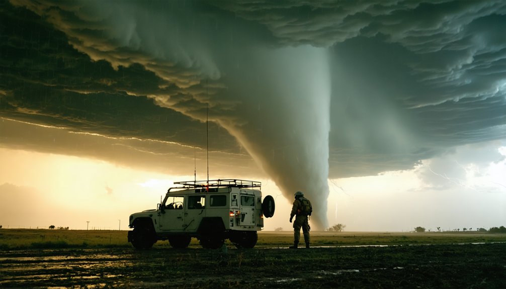
You’ll need ANSI-rated reflective vests and impact-resistant helmets for debris encounters. Implement multi vehicle coordination through Midland MXT575 two-way radios and Garmin inReach Mini 2 satellite communicators when cellular networks fail.
Deploy tow ropes, spare tires, and fix-a-flat solutions for rapid vehicle recovery. Stock defibrillators and thorough EMS kits for lightning strike protocols. Power redundancy requires EcoFlow Delta Pro stations paired with Anker 737 PowerCore banks.
Install polarized optics for enhanced mesocyclone visualization. Apply winterization considerations including cold-weather batteries and thermal protection systems. Thor Guard lightning detectors provide real-time strike proximity data.
These systems guarantee operational autonomy when you’re positioned beyond emergency response infrastructure.
Reading Meteorological Conditions and Warning Signs
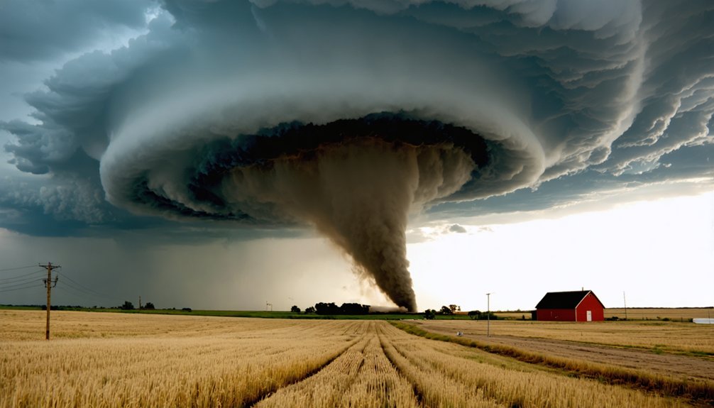
Your equipment suite provides operational capacity, but meteorological interpretation determines whether you intercept significant convective events or waste fuel on non-tornadic storms. Master interpreting visual signs: wall clouds exhibiting rotation persist 10-20 minutes pre-tornadogenesis, while hook echoes and debris balls on radar confirm mesocyclone structure.
Monitor inflow bands—spiraling low cumulus formations indicate organized low-level rotation. Sensing atmospheric changes separates successful chasers from amateurs. That freight-train roar signals proximity to vortex core. Dark greenish skies result from hail refracting sunlight through storm structure. Sudden wind cessation creates deceptive calm before violent onset. High in-cloud lightning frequency precedes funnel formation.
You’re tracking convective systems with lethal potential—develop pattern recognition through repeated field observations rather than relying solely on official warnings that lag real-time storm evolution.
When targeting high-probability convective zones, your navigation protocol must prioritize dynamic escape vectors over static observation positions. Divide Tornado Alley into 35 operational zones through terrain analysis and road network optimization, using state boundaries and river systems as natural delineators.
You’ll maintain autonomous mobility by arriving early at intercept points, repositioning ahead of chaser convergence that creates rural road bottlenecks. Approach supercells from western, southern, or eastern vectors—never traverse northern hail cores where visibility drops to zero.
Position yourself southeast of projected tornado tracks, accounting for typical southwest-to-northeast motion patterns. Your exit strategy demands pre-assessed terrain with multiple egress routes. Reference printed zone maps for rapid decision-making when digital systems fail. Leave positions minutes before convergence transforms open highways into parking lots.
Timing Your Chase: Seasonal Patterns and Peak Activity Periods
Strategic positioning means nothing if you’ve arrived during atmospheric dormancy. Long term tornado trends reveal critical temporal shifts: traditional Tornado Alley experienced 30% fewer strong tornadoes since 1990, while Dixie Alley frequency doubled.
Tornado Alley’s 30% decline mirrors Dixie Alley’s doubling—temporal shifts demand abandoning geographic assumptions for data-driven positioning strategies.
March-May remains ideal, driving peak eastern U.S. threats through warm air-cold air collisions. You’ll find warm season frequency changes significant—summer activity decreased since 1951, with Florida reporting marked reductions.
Cold season tornadoes increased 12% in eastern regions (1951-85 vs. 1986-2020), elevating December-February risks from Louisiana to Virginia. Fall demonstrates heightened September-November activity across Southeast and mid-Atlantic.
The strong tornado centroid shifted 110 miles eastward over three decades. Chase timing demands data-driven seasonal analysis rather than outdated geographic assumptions about when atmospheric instability peaks.
Communication Protocols and Emergency Response Planning
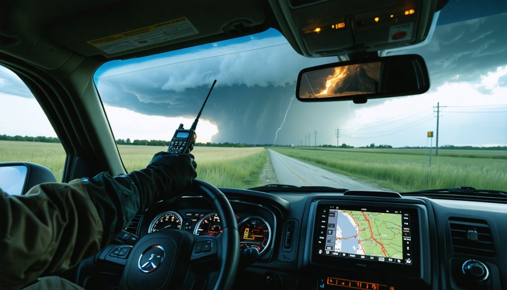
You’ll need integrated real-time weather alert systems that pull data from multiple sources—including XM Weather’s 5-minute radar updates, National Weather Service warnings, and SKYWARN spotter networks—to preserve situational awareness during rapidly evolving storm conditions.
Multi-channel communication redundancy is non-negotiable: configure your systems to operate across amateur radio frequencies (particularly 146.580 MHz), cellular networks with automatic failover capabilities, and satellite phone backup for areas with degraded infrastructure.
This layered approach guarantees you’ll maintain contact with your team, emergency management operations centers, and meteorological support personnel regardless of network failures or geographic isolation.
Real-Time Weather Alert Systems
As storm chasers navigate severe weather environments, real-time alert systems function as the critical interface between meteorological detection and life-saving action. You’ll receive warnings through multiple channels, each leveraging distinct sensor network capabilities:
- Wireless Emergency Alerts transmit tornado warnings directly to your phone via cell towers, delivering county-specific notifications with distinct audio signatures
- NOAA Weather Radio broadcasts continuous updates on dedicated frequencies, maintaining functionality during power outages through battery backup
- Mobile applications integrate high-resolution Doppler radar with customizable color schemes and minutely forecasts
Current systems provide 9-minute average lead times, though experimental WoFS technology extends this to one hour through machine learning integration. Infrasound detection demonstrates 100% accuracy with zero false alarms, eliminating warning fatigue while maximizing your operational freedom.
Multi-Channel Communication Redundancy
When cellular networks collapse under severe weather conditions, storm chasers require redundant communication architectures that maintain operational continuity across multiple frequency bands and transmission protocols.
You’ll need backup communication channels spanning satellite phones, UHF bands (462.650 MHz for GMRS operations), and battery-powered ham radios. Text messaging demonstrates superior reliability over voice calls during network degradation. Establish primary and secondary methods for distinct purposes: urgent resource requests, routine situation reports, and coordination updates.
Your integrated response planning must differentiate between standard operations and incident-specific protocols per FEMA guidelines. Deploy offline-capable equipment compatible with IPAWS and EAS systems. Designate specific frequencies for critical communications while maintaining documentation accessibility.
Configure your systems with both local radio station partnerships and out-of-town communication hubs to guarantee uninterrupted information flow during catastrophic atmospheric events.
Dixie Alley Considerations and Southern Storm Challenges
When you’re chasing in Dixie Alley, you’ll face considerably elevated casualty risks driven by multiple factors: since 1993, Alabama and Tennessee have recorded higher annual tornado fatalities than Kansas and Oklahoma, with the Southeast experiencing maximum tornado casualties compounded by poverty, high population density, and mobile home vulnerability.
The region’s seasonal patterns extend beyond traditional spring peaks, maintaining dangerous activity from February through mid-April and resurging in late autumn, creating complacency during off-season events like the February 2008 Super Tuesday outbreak that killed 57.
Tornado frequency has more than doubled since 1990 for EF2+ storms across the Mississippi, Alabama, Arkansas, Missouri, Illinois, Indiana, Tennessee, and Kentucky corridor, reflecting a documented eastward shift from traditional Great Plains activity.
Higher Casualty Risk Factors
Several geographic and demographic factors converge to make Dixie Alley—encompassing Arkansas, Mississippi, Alabama, and Tennessee—significantly more lethal than traditional Tornado Alley. You’re traversing terrain where manufactured home reconstruction lags behind tornado frequency increases, creating 15-20 times higher fatality risk compared to permanent structures. Population exposure mitigation remains inadequate as growth outpaces safety infrastructure development.
Critical risk multipliers include:
- Nighttime tornado prevalence: Over 50% of deaths occur during nocturnal events when warning effectiveness diminishes drastically
- Housing vulnerability: Southeastern permanent homes feature weaker structural frames than other regions, compounding manufactured housing dangers
- Population density concentration: Dense Southern populations intersect with high-frequency tornado corridors, elevating casualty potential
The 2011 Super Outbreak demonstrated these convergent factors, killing over 300 people. Understanding these data-driven patterns enables autonomous risk assessment and informed decision-making.
Extended Seasonal Activity Patterns
Beyond casualty demographics, temporal threat distribution fundamentally alters your chase planning calculus in Dixie Alley. You’ll encounter tornadogenesis across four distinct seasons rather than spring’s concentrated window, with peak periods spanning February through mid-April and extending into late autumn.
This dispersed temporal pattern creates reduced public preparedness—winter events yield fewer institutional drills and complacency among populations. Proximity to Gulf moisture sources maintains persistent instability well past traditional diurnal heating cycles, producing significant after-dark tornado frequency when visibility approaches zero.
Eastern Arkansas through central Tennessee demonstrates frequency doubling since 1990, with autumn seasons showing substantial count increases from Mississippi to Indiana. You’re targeting high-precipitation supercells in rain-wrapped configurations where dense canopy cover eliminates visual verification protocols that’d work in traditional Great Plains environments.
Analyzing Historical Data to Predict Future Tornado Paths

Historical tornado data from 1950–2018 reveals significant spatial and temporal shifts that directly impact where you’ll find the most active storm systems today. The centroid of strong tornado tracks has migrated 110 miles eastward over three decades, fundamentally altering traditional chase zones. You’re now looking at spatial variability that’s shifted activity 12% higher in eastern regions while western areas dropped 25%. Temporal variability shows tornadoes trending from warm-season peaks toward cold-season emergence.
Tornado activity has shifted 110 miles eastward over thirty years, demanding updated chase strategies beyond traditional Tornado Alley boundaries.
Key predictive metrics you’ll need:
- F/EF1+ tornado datasets show minimal reporting bias, providing reliable spatial shift confirmation
- Climate indices (NAO, PDO, AMO, SOI) explain multi-decadal variability patterns across regions
- Tornadogenesis events and pathlength data confirm sustained eastward migration trends
Your chase strategy must adapt to this documented eastern concentration rather than outdated Tornado Alley assumptions.
Frequently Asked Questions
What Insurance Coverage Do Professional Storm Chasers Need for Their Vehicles?
You’ll need all-encompassing vehicle policies covering hail, wind, and structural damage, plus liability insurance coverage for accidents. However, insurers may deny claims if they discover intentional storm exposure, so you’ll face significant coverage gaps and potential policy cancellations.
How Do Storm Chasers Make Money From Their Tornado Footage?
Like modern-day treasure hunters, you’ll monetize chase footage marketing by licensing tornado videos to networks, news agencies, and documentaries. Selling storm videos generates $70,000 annually through brokers, though platforms now capture 95% of digital revenue, threatening profitability.
What Are the Legal Requirements for Filming Tornadoes on Private Property?
You’ll need explicit owner consent for legal property access before filming tornadoes on private land. Ethical filming practices require written permission, avoiding trespass violations. From public roads, you’re free to document storms without permits or restrictions.
How Much Does a Complete Storm Chasing Setup Typically Cost?
You’ll break the bank initially—average storm chasing equipment costs run $4,000-$5,000 for electronics and software, while typical storm chasing vehicle expenses add $2,000-$3,000 annually for fuel, maintenance, and modifications, totaling approximately $6,000-$8,000 your first season.
Can Storm Chasers Claim Tax Deductions for Their Chase-Related Expenses?
Yes, you can deduct chase expenses if you prove profit motive. Vehicle maintenance costs, equipment depreciation, mileage, and documentation are critical. However, hobby classification limits deductions. Maintain detailed logs to satisfy IRS Section 162 requirements and avoid penalties.