Mesocyclones form when your storm’s updraft tilts horizontal vorticity—created by wind shear in the lowest 500 meters—into the vertical plane. You’ll see this rotation intensify as the updraft’s convergence stretches the vortex, accelerating winds to 100 mph at mid-levels through conservation of angular momentum. The process requires specific ingredients: steep lapse rates for buoyancy, directional shear to separate updraft from downdraft, and sufficient moisture. Understanding the complete tilting-stretching sequence reveals how supercells generate their devastating rotating cores.
Key Takeaways
- Vertical wind shear in the lower atmosphere creates horizontal vorticity that updrafts tilt upward into vertical rotation.
- Strong updrafts stretch vertically-oriented vorticity through convergence, intensifying rotation to mesocyclone strength at mid-levels.
- Directional wind shear separates updraft from downdraft regions, preventing precipitation from collapsing the rotating column.
- Dynamic pressure perturbations accelerate low-level inflow into the updraft, enhancing rotation and sustaining organized circulation.
- Hodograph curvature promotes cyclonic-dominant rotation while rear-flank downdrafts concentrate circulation near the surface.
Environmental Ingredients That Set the Stage
Before a supercell can develop its characteristic rotating updraft, specific atmospheric conditions must align in precise vertical layers. You’ll find the thermodynamic profile creates conditional instability when cool, dry air at middle levels overlies warm, moist surface air. This steep thermal gradient enables rapid parcel ascent once saturation’s achieved.
Low level moisture concentrates near Earth’s surface, where high relative humidity lowers the condensation level for developing mesocyclones. The moisture distribution you’re observing directly influences updraft strength through latent heat release during condensation.
Dry mid-to-upper tropospheric air becomes critical for rear-flank downdraft formation via evaporative cooling. These vertical arrangements of temperature and moisture aren’t regulatory constraints—they’re natural atmospheric configurations that permit supercell development when conditions favor unrestricted convective processes.
The Critical Role of Wind Shear in Storm Organization
Wind shear—the variation in wind speed and direction with height—directly controls whether a thunderstorm evolves into a supercell or remains ordinary.
You’ll observe that strong vertical shear in the lowest 500 meters generates horizontal vorticity, which the updraft subsequently tilts into the vertical plane through a precise mechanism involving streamwise vortex ingestion.
This tilting process transforms environmental shear into organized rotation, fundamentally restructuring the storm’s internal dynamics and precipitation distribution.
Wind Speed Height Changes
The vertical structure of atmospheric winds determines whether a thunderstorm evolves into a supercell or remains an ordinary multicellular system. You’ll observe that increasing wind speeds with altitude create the essential environmental conditions for mesocyclone development.
This vertical gradient in velocity organizes updraft structures, transforming chaotic convection into sustained rotation. When winds shift from southerly at the surface to westerly or southwesterly aloft, you’re witnessing directional shear that tilts the updraft away from precipitation.
Unidirectional wind shear alone won’t suffice—you need significant speed differentials throughout the column. This velocity profile enables your updraft to remain separate from downdraft processes, extending storm longevity from minutes to hours. The shear-induced tilting creates the geometric framework necessary for mesocyclone intensification.
Horizontal Vorticity Tilting Mechanism
As storm-relative winds encounter your developing supercell’s updraft, they bring with them horizontal vorticity—rotational motion spinning around a horizontal axis at approximately 0.01 s⁻¹. Your updraft tilts this horizontal vorticity upward, converting it directly into vertical vorticity that defines mesocyclone rotation. Baroclinic generation enhances this process along the forward-flank downdraft boundary, where temperature gradients produce additional horizontal vorticity.
In unidirectional shear environments, tilting creates counter-rotating vortex pairs, but hodograph curvature shifts this pattern toward single-sign cyclonic dominance. Boundary layer impacts prove critical as streamwise vorticity aligns with storm-relative inflow vectors. The perturbation pressure field then converts vertical shear vorticity into curvature vorticity, establishing the closed circulation patterns you observe as mesocyclone formation. Stretching subsequently amplifies this rotation through convergence.
Supercell Updraft Organization Process
Beyond vorticity tilting mechanics lies the organizational framework that transforms ordinary convective cells into persistent supercell thunderstorms. You’ll observe how vertical wind shear fundamentally restructures convective architecture through pressure flow interactions.
When environmental shear exceeds 25 m/s through the lowest 4-6 km, dynamic perturbation pressure gradients dominate buoyant forces, accelerating low-level inflow and establishing rotating updraft cores. These vorticity development mechanisms separate precipitation-laden downdrafts from ascending parcels, guaranteeing updraft contamination doesn’t occur.
Critical organizational processes:
- Dynamic pressure forces equal or exceed buoyancy in supporting your storm’s rotational intensity
- Updraft-downdraft isolation guarantees uninterrupted vertical motion through precipitation advection
- Low-level shear of 10-20 m/s triggers systematic new cell development along outflow boundaries
- Hodograph curvature dictates supercell motion vectors and structural evolution patterns
This shear-driven organization liberates convection from typical multicellular constraints.
How Horizontal Vorticity Becomes Vertical Rotation
The supercell’s updraft tilts this horizontal spin upright, converting paddle-wheel motion into vertical mesocyclone rotation at 4-8 km altitudes. Streamwise vorticity—aligned with storm-relative winds—becomes dominant as tilting intensifies.
Vertical stretching then amplifies this vorticity through convergence, contracting the mesocyclone to 2-6 km diameter while spinning up rotation exceeding 10^-2 s^-1. You’re witnessing nature’s transformation of horizontal environmental vorticity into concentrated vertical power.
Updraft Dynamics and Mesocyclone Development
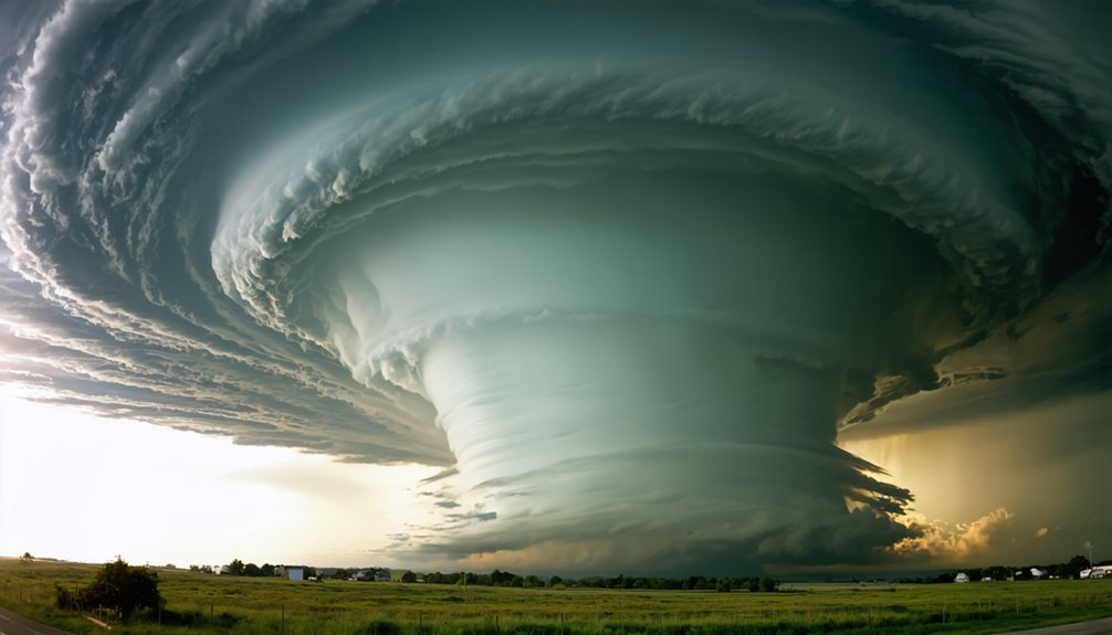
Once horizontal vorticity transforms into vertical rotation, the updraft becomes the engine amplifying this spin into a full mesocyclone. Your updraft’s buoyancy—air rising 5-10°C warmer than its environment—creates explosive vertical acceleration. This stretching intensifies rotation through convergence, with speeds exceeding 100 mph at mid-levels where the mesocyclone first develops. The thermodynamic impacts generate pressure drops reaching 10 mbars, forming a vacuum that draws surrounding air inward.
Critical updraft-mesocyclone interactions:
- Barbell-shaped updraft structure creates devastating rotational efficiency
- Rear flank downdraft tightens surface circulation into tornado-capable vortices
- Flanking line convergence sustains unstoppable vertical motion
- Cyclic mesocyclone replacement extends supercell lifespan beyond conventional constraints
Environmental wind shear provides the initial horizontal vorticity, but your updraft’s relentless vertical stretching transforms available rotation into the mesocyclone’s concentrated power.
The Stretching and Tilting Mechanism Explained
As supercell updrafts encounter environmental wind shear, horizontal vorticity undergoes tilting that transforms ground-parallel rotation into the vertical spin defining mesocyclones. You’ll observe this mechanism strongest between 10,000–20,000 feet, where streamwise vorticity reorients along the updraft core.
The process intensifies through vertical vorticity stretching, which aggregates and tightens circulation as air columns contract vertically. Baroclinic vorticity enhancement in the forward flank augments this system—precipitation-driven temperature gradients generate additional horizontal vorticity that tilts toward vertical orientation. This dual mechanism produces correlations between vertical velocity and vorticity exceeding 10⁻² s⁻¹.
When stretching extends rotation downward to ground level, you’re witnessing the critical pathway from mid-level mesocyclone to potential tornadogenesis, particularly where storm-relative helicity maximizes the tilting factor through ideal shear-updraft alignment.
From Mid-Level to Low-Level Mesocyclone Evolution

The mesocyclone’s descent from mid-levels to the surface represents a critical evolutionary pathway in supercell development. You’ll observe this process beginning at 3-6 km AGL, where persistent rotation first establishes itself through updraft-induced tilting of horizontal vorticity.
As conditions evolve, the mesocyclone base (M-BASE) descends from approximately 4.7 km to 3.0 km, eventually spawning surface-level rotation near cloud base at ~1 km AGL through baroclinic vorticity generation and stretching mechanisms.
Mid-Level Rotation Initiation
When environmental wind shear sets horizontal vorticity in motion, the supercell’s updraft performs a critical transformation—tilting this horizontal spin into vertical rotation that marks the birth of a mid-level mesocyclone. Vertical wind shear influences this process by creating ambient horizontal vorticity from environmental velocity differences. The updraft tilts this streamwise vorticity upright, converting horizontal rotation into vertical circulation.
As parcels accelerate upward, vertical stretching intensifies the rotation through angular momentum conservation, tightening the pressure gradient and strengthening the vortex core. Parcels and updraft momentum work together—the stronger updraft ingests environmental mass while stretching the circulation vertically.
Critical development indicators:
- 2-10 km diameter rotating column emerges from seemingly chaotic convection
- 15 m/s rotational velocity threshold signals nature’s raw atmospheric power
- 3 km vertical depth demonstrates unstoppable upward acceleration
- 10-minute persistence confirms sustained mesocyclone independence
Downward Vorticity Extension Process
Once the mid-level mesocyclone achieves cyclostrophic balance between 4-8 km altitude, it transforms into a dynamic pipe that aggressively draws environmental air through its lower terminus.
You’ll observe the rear-flank downdraft transporting angular momentum downward while simultaneously advecting vertical vorticity toward near-ground levels. The downdraft’s cool air enhances baroclinic generation along temperature gradients, creating horizontal vorticity that tilts vertical between descending and ascending motions.
Vorticity concentration intensifies through angular momentum conservation as parcels spiral inward, contracting the circulation from 10-20 km diameter to 2-6 km. Vertical stretching from convergence accelerates this positive-feedback mechanism—faster rotation strengthens base-level inflow, which further amplifies stretching.
Near-ground friction generates additional horizontal vorticity, feeding the intensification cycle that extends mesocyclone structure downward through the storm’s entire vertical profile.
Surface Mesocyclone Development
As downward vorticity extension establishes the framework for surface interaction, low-level mesocyclone development depends critically on the character of horizontal vorticity within the lowest 500 meters. You’ll observe streamwise vorticity ingestion creating powerful surface rotation through updraft stretching, while crosswise configurations inhibit intensification.
Rear flank downdraft strength drives vortex consolidation near the surface through evaporative cooling and vertical pressure gradients. Precipitation structure evolution influences mesocyclone diameter and intensity—HP supercells exhibit extensive wrap with weaker rotation, while classic configurations maintain concentrated vorticity. Wall cloud formation signals impending tornado development.
Critical surface mesocyclone factors:
- Streamwise vorticity ingestion releases tornadic potential through dynamic lifting enhancement
- RFD surge timing determines whether scattered vortices consolidate or dissipate
- Precipitation wrap geometry constrains rotational velocity and mesocyclone structure
- Low-level updraft acceleration stretches vertical vorticity into coherent surface circulation
Radar Signatures of Supercell Mesocyclones

Doppler weather radar reveals mesocyclone structure through several diagnostic signatures that enable meteorologists to identify, track, and evaluate rotating updrafts within supercell thunderstorms. You’ll observe rotational couplets on velocity displays, where inbound and outbound wind branches create characteristic patterns marking cyclonic rotation.
Hook echoes form as precipitation cascade wraps counterclockwise around the updraft base, indicating mesocyclone location. Bounded weak echo regions appear as low-reflectivity vaults, signaling strong updrafts suspending particles aloft.
Enhanced reflectivity zones reveal hail core dynamics, with three-body scatter spikes extending radially behind main cores at elevated scan angles. Sharp reflectivity gradients perpendicular to rear-flank downdrafts mark intense updraft boundaries. These quantifiable signatures provide critical data for assessing supercell severity and tornado potential through systematic radar analysis.
Downdrafts and Their Interaction With the Rotating Updraft
While the mesocyclone’s rotating updraft forms the core of supercell dynamics, downdrafts establish the critical forcing mechanisms that intensify low-level rotation and sustain storm longevity. The rear flank downdraft role centers on evaporative cooling from dry mid-level air entrainment, creating negative buoyancy that drives descending flow along the precipitation-wrapped mesocyclone backside.
Downdrafts drive the engine: evaporative cooling creates descending flow that completes the circulation and amplifies the mesocyclone’s deadly rotation.
Forward flank downdraft characteristics involve precipitation-dragged air northeast of the updraft, supplying high-humidity parcels that lower cloud bases and form wall clouds.
Critical interaction dynamics:
- Cold downdraft air penetrates the updraft base, completing circulation and stretching vertical vorticity upward
- Convergent outflow boundaries generate concentrated low-level rotation through vorticity amplification
- Pressure gradients tighten as updraft contracts, accelerating environmental inflow
- Symbiotic balance propagates the supercell into regions of enhanced cyclonic shear
Frequently Asked Questions
Can Mesocyclones Form Over Oceans or Only Over Land?
Like atmospheric engines churning wherever conditions permit, mesocyclones aren’t landlocked—you’ll find them forming over oceans when sufficient wind shear exists. Ocean temperature gradients and ocean surface roughness provide necessary instability and convergence, enabling supercell development beyond terrestrial boundaries.
How Do Forecasters Predict Which Mesocyclones Will Actually Produce Tornadoes?
You’ll analyze radar reflectivity patterns like hook echoes combined with environmental shear profiles—particularly 0-3 km storm-relative helicity and mid-level winds—while integrating CAPE values and machine learning algorithms to calculate tornado probability independently.
What Percentage of Mesocyclones Actually Spawn Tornadoes?
You’ll find tornado probability remains surprisingly low—fewer than 20% of mesocyclones spawn tornadoes. Mesocyclone dynamics involve complex interactions between rear-flank downdrafts, low-level shear, and boundary-layer conditions that you can’t always predict with current technology.
Are Mesocyclones Becoming Stronger or More Frequent Due to Climate Change?
You’ll find mixed signals: atmospheric moisture content increases with global temperature trends, potentially boosting mesocyclone intensity, but frequency trends remain uncertain. Regional variations exist, though definitive global patterns haven’t emerged from current observational data through the 2020s.
How Close Can Storm Chasers Safely Get to an Active Mesocyclone?
You’ll maintain storm chaser safety precautions by staying several miles away from active mesocyclones. Ideal viewing distances exceed the rotation’s diameter, ensuring your radar remains functional while you independently assess velocity couplets and tornado potential without compromising situational awareness.

