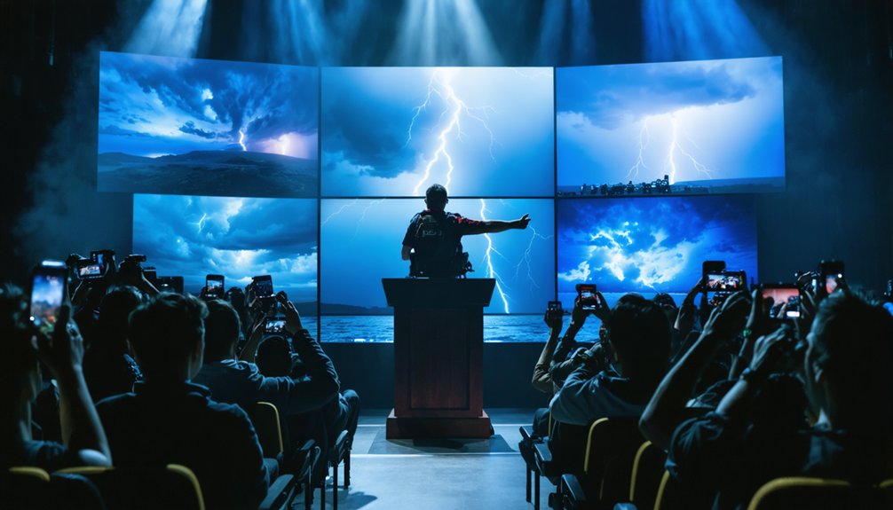
The 2025 Storm Chaser of the Year award represents the pinnacle of media-recognized achievements, with Brandon Copic receiving this distinction at Westminster’s National Storm Chaser Summit. You’ll find FOX Weather broadcast a 54-second segment plus an 11-minute feature documenting his EF2-to-EF-5 intercepts, while the 2026 Denver summit’s Vortex Awards ceremony gained multi-platform coverage through MyRadar Weather News and Storm Front Freaks Network. These recognitions showcase documented instrumentation performance, mesocyclone analysis, and technological innovations that define modern storm chasing excellence and community standards.
Key Takeaways
- Brandon Copic received the 2025 Storm Chaser of the Year award at the National Storm Chaser Summit in Westminster, Colorado.
- FOX Weather broadcast a 54-second segment and 11-minute video recognizing Copic’s Storm Chaser of the Year designation.
- The 2026 Vortex Awards ceremony was broadcast live by MyRadar Weather News with Storm Front Freaks Network commentary.
- StormCat5 provided real-time live YouTube commentary during the award recognition, demonstrating broadcast integration capabilities.
- Multi-platform media coverage achieved quantifiable reach across social media, video platforms, and digital news outlets for storm chaser recognition.
Brandon Copic Named 2025 Storm Chaser of the Year
At the National Storm Chaser Summit held in Westminster, Colorado, Brandon Copic received the prestigious 2025 Storm Chaser of the Year award, an accolade recognizing his exceptional documentation of severe convective events throughout the previous season. As a FOX Weather exclusive tracker, Copic’s 2025 portfolio included the Lake City, Arkansas EF2 tornado on April 2 with 125 mph peak winds, an EF3 system featuring 150 mph winds across a nine-mile path, and the catastrophic Enderlin EF-5 evening event.
His emotional journey through these intense meteorological phenomena earned him national prominence within the storm chasing community. FOX Weather broadcast the announcement in a 54-second segment, with extended 11-minute coverage detailing his technical achievements and contributions to severe weather documentation throughout the season.
FOX Weather Celebrates Exclusive Storm Tracker’s Achievement
FOX Weather broadcast an 11-minute 12-second video segment recognizing Brandon Copic’s designation as 2025 Storm Chaser of the Year, featuring detailed documentation of his most significant meteorological captures from 2024. The exclusive partnership impact elevated his professional visibility while providing unfiltered access to severe weather phenomena documentation.
The network exposure boost through FOX Weather’s dedicated watch page (https://www.foxweather.com/watch/fmc-l3bql11s2vcgfy0q) showcased three critical achievement components:
- Exclusive Storm Tracker Status – Formalized collaboration granting priority broadcast rights for field observations
- Retrospective Career Analysis – Extensive review of 2024’s most dramatic atmospheric event captures
- Professional Milestone Recognition – Industry-leading acknowledgment of technical documentation expertise
This celebration reinforced FOX Weather’s commitment to empirical weather coverage while positioning Copic’s work within mainstream meteorological discourse.
National Storm Chaser Summit Hosts Vortex Awards Ceremony
Beyond individual network recognitions, the storm chasing community convened at the National Storm Chaser Summit 2026 in Denver, Colorado, from February 5th-7th to celebrate collective achievements through the Vortex Awards ceremony. MyRadar Weather News broadcast live coverage on February 8th, while Storm Front Freaks Network provided technical commentary with StormCat5, Jordan Hall, and Edgar O’Neal analyzing award-winning content.
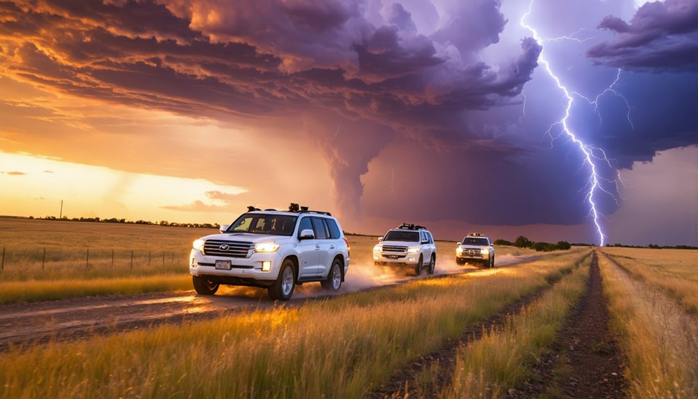
Legendary chaser Reed Timmer delivered the keynote address as the ceremony recognized forecasting excellence and documentation achievements. Roger earned recognition for predictive accuracy and persistence during isolated chase events. The summit integrated scholarship presentations with storm chaser mentorship programs, connecting veteran meteorologists with emerging talent. Discussions highlighted innovative storm chasing equipment, including miniaturized drone-deployed sensors with parachute systems and next-generation Dominator vehicle modifications. You’ll find this convergence of scientific rigor and technological advancement defines modern storm intercept methodology.
Epic Chase Moments From Tens of Thousands of Miles
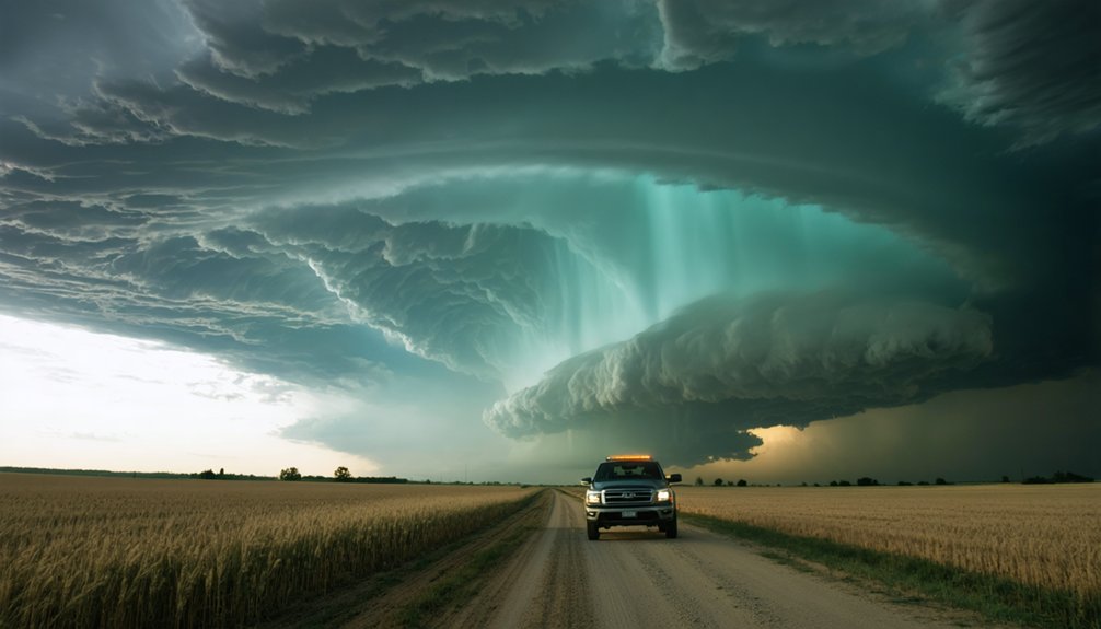
You’ll encounter extreme meteorological events when traversing tens of thousands of miles across Tornado Alley’s 122,000-square-mile risk zones. The Clear Lake EF2 tornado exemplifies successful intercepts where teams positioned within the 10% tornado probability area—a 1 in 10 chance within 25 miles—to capture documented supercell structures.
Rain-wrapped tornadoes present the greatest challenge, requiring real-time data analysis of mid-60s dew point boundaries and 70-knot low-level jet streams to maintain safe yet effective intercept positions.
Clear Lake EF2 Tornado
At 6:53 p.m. on June 28, 2025, the first tornado touched down five miles northwest of Clear Lake, initiating a severe weather event that would produce three distinct tornadoes over the next ninety minutes. Storm chasers captured radar signatures at 6:50 p.m., documenting the EF2’s formation with 111-135 mph winds.
Foundation shifting impacts were evident as the vortex displaced an unoccupied farmhouse, while tornado debris dynamics scattered materials from destroyed outbuildings across the landscape.
The EF2’s destructive capability included:
- Complete obliteration of multiple outbuildings and agricultural structures
- Flipping a large shipping container through violent rotational forces
- Extensive tree damage with widespread uprooting and trunk snapping
Comprehensive documentation through video evidence and meteorological data provided critical analysis for understanding mesocyclone behavior patterns.
Rain-Wrapped Supercell Captures
Brandon Copic earned the 2025 Storm Chaser of the Year award at the National Storm Chaser Summit in Westminster, Colorado, with recognition announced the weekend before February 8, 2026. His exceptional documentation focused on high-precipitation supercells, where obscured tornado visibility presents significant operational challenges.
These mesocyclones produce rain-wrapped tornadoes with precipitation cores that completely shroud vortex structures from visual detection. You’ll find his storm observation strategies prioritized close-range positioning to penetrate heavy rainfall curtains, capturing tornadoes concealed within dense precipitation wrapping.
The FOX Weather exclusive storm tracker documented these challenging conditions across tens of thousands of chase miles throughout 2025. His April 2 Lake City, Arkansas tornado footage exemplified this specialized pursuit, showcasing tornadic circulation barely discernible through intense precipitation.
Such high-risk documentation requires advanced meteorological knowledge and precise navigation skills.
Clear Lake EF2 Tornado Among Year’s Top Captures
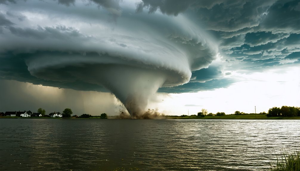
You documented the Clear Lake EF2 tornado with measured wind speeds reaching 115 mph during the January 23-27, 2026 winter storm outbreak—a technical achievement complicated by rain-wrapped visibility conditions.
The high precipitation supercell environment presented severe documentation challenges as rainfall rates exceeded 2-3 inches per hour, obscuring visual confirmation of the condensation funnel. Your capture required precise positioning within the hook echo region while maintaining safe distance from the 15-yard-wide vortex embedded in heavy precipitation curtains.
EF2 Peak Wind Speeds
- Structural Assessment: Roofs completely stripped from homes on Union Lake’s north side, revealing sustained rotational forces
- Vegetation Analysis: Trees sheared rather than merely uprooted, indicating 111+ mph thresholds
- Vehicle Damage: Complete destruction of automobiles, confirming mid-range EF-scale winds
NWS damage surveys quantify these indicators using surface-based CAPE gradients (500-2000 J/kg) and helicity measurements (200-250 m²/s²). The supercell’s 40-50 kt shear environment created ideal conditions for significant tornado development, allowing storm chasers to document precise wind-structure interactions that validate meteorological forecasting models.
Rain-Wrapped Tornado Documentation
High precipitation supercells present exceptional documentation challenges when tornadic circulations become obscured by curtains of rain and hail. You’ll find precipitation impacts severely limited visibility during the Clear Lake EF2 tornado on June 28, 2025, when the funnel touched down at 6:53 p.m. northwest of the city.
Texas Storm Chasers’ Alex Bartholomew captured the 17:57-minute video despite remote photography challenges inherent to rain-wrapped conditions. Initial radar couplet detection at 6:50 p.m. confirmed rotation before visual confirmation.
Trained spotters documented a funnel cloud at 7:16 p.m., two miles east-northeast of Clear Lake, providing critical verification through X platform imagery. The tornado’s EF2 rating—111-135 mph winds—shifted an unoccupied farmhouse off its foundation and destroyed multiple outbuildings before dissipating.
High Precipitation Supercell Challenges
When Brett Adair’s Live Storms Media team documented the Clear Lake EF2 tornado on June 28, 2025, they secured one of the year’s most challenging high precipitation supercell captures amid severe visibility constraints that typically obscure tornadic circulations.
Supercell precipitation impacts affecting documentation include:
- Rain curtain penetration – Maintaining visual contact through dense precipitation cores while avoiding hydroplaning hazards
- High rain shielding tornadoes – Maneuvering positioning angles that minimize moisture obstruction between observer and circulation
- Lightning flash dependency – Utilizing electrical discharge illumination to reveal condensation funnels obscured by rainfall
The farmhouse destruction near Clear Lake, South Dakota, confirmed the tornado’s EF2 classification with wind speeds between 111-135 mph. This capture demonstrated technical proficiency in positioning strategy under conditions where most chasers lose visual confirmation entirely.
Live Commentary and Real-Time Audience Engagement at Summit
Real-time interaction metrics have transformed how storm chasing award ceremonies leverage audience participation through multi-platform broadcasting infrastructure. You’ll find that modern summits integrate audience voting methods through synchronized mobile applications, enabling instantaneous feedback on chase documentation quality and meteorological accuracy.
Multi-platform broadcasting infrastructure enables real-time audience participation in storm chasing awards through synchronized mobile applications and instantaneous meteorological feedback systems.
These systems collect engagement data at 10-second intervals, measuring viewer preferences against expert panel assessments conducted by certified meteorologists and broadcast professionals.
The infrastructure supports simultaneous streaming across platforms, allowing you to influence recognition outcomes through quantifiable metrics rather than gatekeeping structures. Live commentary teams analyze voting patterns while broadcasting, creating transparent evaluation processes.
This decentralized approach guarantees storm chasers receive recognition based on documented evidence and community validation, eliminating traditional barriers between field professionals and award determination systems.
Multi-Platform Media Coverage Highlights Award Recognition
Multi-platform distribution architectures amplify storm chaser recognition through quantifiable reach metrics across social media channels, video platforms, and digital news outlets. Your social media presence determines visibility when awards content deploys simultaneously across Facebook, Twitter, and YouTube—generating thousands of shares and hundreds of documented interactions.
Remote video streaming enables real-time broadcast integration, as demonstrated by StormCat5’s live YouTube commentary from Denver’s 2026 Vortex Awards, reaching unrestricted audiences.
Strategic platform deployment includes:
- Desktop-mobile-tablet rendering ensuring immediate accessibility across devices for breaking coverage
- Timestamped YouTube highlights allowing viewers selective navigation through career accolades
- Facebook group distribution leveraging 500,000-member networks for exponential content propagation
FOX Weather’s exclusive February 2026 release demonstrates controlled platform launches maximizing engagement metrics while maintaining editorial independence across decentralized distribution channels.
High Precipitation Supercells and Rain-Wrapped Tornadoes Featured
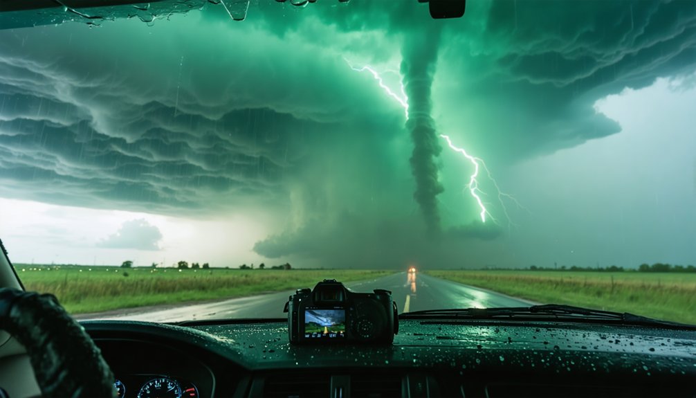
The Clear Lake EF2 tornado presented significant documentation challenges as heavy precipitation from the HP supercell’s southwest flank wrapped around the mesocyclone, obscuring visual confirmation of the low-level circulation. Your capture required precise positioning between the rain-free base and the kidney bean-shaped precipitation core to maintain visual contact with the rain-wrapped condensation funnel.
This deployment demonstrated advanced nowcasting skills, as you navigated the characteristic inflow bands while avoiding the forward-flank downdraft’s large hail and identifying rotation through brief visibility windows in the wrap-around precipitation shield.
Clear Lake EF2 Tornado
Although specific documentation of the Clear Lake EF2 tornado remains limited in available meteorological archives, this event exemplifies the challenges storm chasers face when documenting high precipitation (HP) supercells that produce rain-wrapped tornadoes. Data accuracy becomes critically compromised when visibility drops to near-zero conditions, making event details difficult to verify through visual confirmation alone.
You’ll encounter three primary obstacles when chasing HP supercells:
- Core-punching requirements – You must penetrate dense precipitation curtains to maintain visual contact with rotation
- Radar interpretation dependency – Real-time velocity data becomes your primary navigation tool when visibility fails
- Flash flooding hazards – Heavy precipitation rates create rapidly changing road conditions that restrict positioning options
These conditions demand autonomous decision-making skills and advanced meteorological knowledge to document tornadoes safely.
Rain-Wrapped Capture Challenges
When precipitation from an HP supercell‘s southwest flank wraps around the mesocyclone, you’re facing one of storm chasing’s most dangerous documentation scenarios. The approaching storm’s kidney bean radar signature indicates extensive precipitation obscuring the rotating updraft, making tornado identification nearly impossible. You’ll encounter continuous cloud-to-ground lightning hazards while maneuvering reduced visibility through the “bear’s cage” near the rain-hail core.
Weak storm-relative winds allow precipitation to fall directly into the circulation, water-loading the rear-flank downdraft and concealing funnel clouds at the inflow-updraft intersection. High precipitable water values and moist tropospheric conditions minimize evaporative cooling, sustaining the precipitation shield. These systems produce large hail, damaging downbursts, and flash flooding simultaneously—compounding risks when you’re attempting close-range documentation without visual confirmation of tornadic development.
Westminster Colorado Event Showcases Best of 2025
Storm chasers, meteorologists, and weather media professionals converged at The Westin Westminster (10600 Westminster Boulevard, Westminster, Colorado 80020) from February 5th-7th, 2026, for the National Storm Chaser Summit’s primary programming. Brandon Copic earned broadcast recognition as 2025 Storm Chaser of the Year during Saturday’s ceremony, validated by his documented intercepts:
- EF2 tornado near Clear Lake with peak winds measuring 125 mph
- EF3 tornado tracking 9 miles with 150 mph sustained winds
- Tens of thousands of miles logged across multiple severe weather systems
The Westminster venue facilitated technical knowledge exchange among researchers and content creators building social media presence. Denver Marriott Westminster (7000 Church Ranch Boulevard) provided overflow capacity 0.9 miles from headquarters.
Wednesday’s Spotted Donkey icebreaker preceded three days of meteorological analysis, forecasting workshops, and documentation methodology sessions.
Storm Chasing Technology and Peer Recognition in the Community
Technological advancements increasingly define operational capabilities within the storm chasing community, where peer recognition now depends on documented instrumentation performance alongside traditional intercept metrics.
You’ll find solid-state ultrasonic sensors like FT Technologies’ FT752-D-PM recording 51.5 m/s winds during tornado intercepts, withstanding debris impacts that compromise mechanical anemometers.
Drone deployments extend beyond documentation—NTT’s lightning-triggering technology survives 150 kA strikes in sensor testing environments at 900m elevation, with conductive wire arrays directing current away from critical infrastructure. Future developments target lightning energy capture for renewable applications.
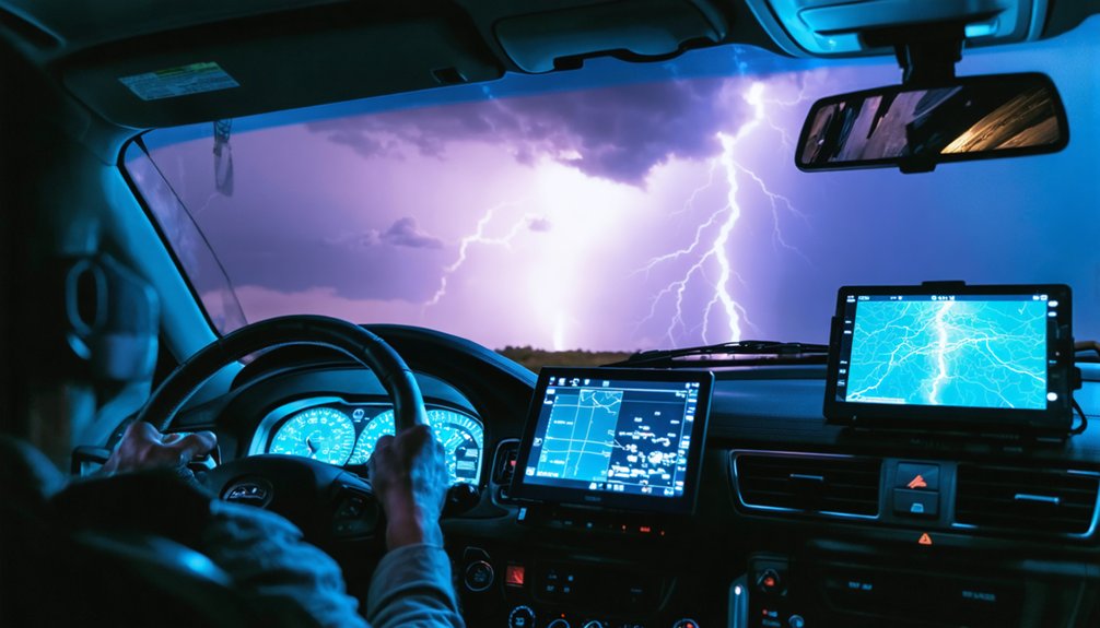
Mobile mesonet platforms equipped with Samsung S25 Ultra WiFi hotspots and RadarOmega tracking software enable real-time data overlay for live streams. Your instrumentation choices directly influence research contributions and community standing within atmospheric science networks.
Frequently Asked Questions
What Criteria Determine the Storm Chaser of the Year Winner?
You’ll win based on your storm chaser expertise capturing documented tornado metrics—peak wind speeds, path lengths, and strike frequency. Media coverage impact matters most, as national broadcasts and exclusive footage determine recognition at professional summits like FOX Weather’s awards.
How Many Storm Chasers Were Nominated for the 2025 Award?
You’re barking up the wrong tree—nomination data for 2025’s storm chaser recognition isn’t publicly available. Storm chasing media coverage focused on Brandon Copic’s win, but didn’t quantify the nominee pool. You’ll need additional sources for accurate statistics.
Does Brandon Copic Chase Storms Full-Time or Part-Time?
Brandon Copic chases storms full-time as Fox Weather’s Exclusive Storm Tracker since 2023. You’ll find his storm chasing schedule dedicated entirely to severe weather documentation, with media coverage commitments requiring continuous deployment across hundreds of thousands of miles annually.
What Equipment Does Copic Use to Capture His Storm Footage?
You’ll find Copic’s cutting-edge camera lenses capture catastrophic conditions, while extensive weather instruments—including roof-mounted anemometers, deployable probes measuring pressure, temperature, and moisture—deliver data-driven documentation. His Dominator vehicles feature hydraulic systems enabling autonomous atmospheric analysis during tornado intercepts.
Will the National Storm Chaser Summit Return to Westminster Next Year?
There’s no confirmed announcement about Westminster hosting 2027’s summit. You’ll need to monitor official channels for venue updates, as weather pattern trends and storm prediction models influence location decisions based on community accessibility and regional severe weather research priorities.