Storm chasers target supercell storms in Tornado Alley because you’re dealing with the most structurally complex and destructive storm type on Earth. Supercells generate over 90% of all violent EF4 and EF5 tornadoes through a deep rotating updraft called a mesocyclone. Tornado Alley’s collision of warm Gulf moisture, cold continental air, and extreme wind shear creates predictable, high-frequency intercept windows found nowhere else. Every supercell encounter reveals atmospheric mechanics operating at maximum intensity, and there’s far more to unpack about what makes these storms worth chasing.
Key Takeaways
- Supercells produce the most violent tornadoes, including EF4 and EF5, making them the highest-value targets for storm chasers seeking extreme weather.
- Tornado Alley’s unique atmospheric conditions, where warm Gulf air meets cold continental air, create ideal supercell development environments.
- Distinct radar signatures like hook echoes allow chasers to identify and intercept supercells hours before they become dangerous.
- Field data collected during chases supports critical research projects like VORTEX, improving tornado forecasting and public warning systems.
- Flat terrain and predictable storm tracks in Tornado Alley give chasers extended sightlines and reliable positioning opportunities.
What Makes a Supercell Different From Every Other Storm?
When most thunderstorms develop and collapse within an hour, a supercell can sustain itself for several hours through a single defining feature: a deep, persistent, rotating updraft called a mesocyclone.
This rotation separates the supercell’s storm structure from every ordinary thunderstorm you’ll encounter.
Standard storms choke themselves off when rain-cooled downdrafts cut their updrafts. A supercell’s unique supercell characteristics solve this problem by spatially separating updrafts from downdrafts, allowing continuous inflow of warm, unstable air.
That mechanical efficiency lets the storm generate large hail, damaging surface winds, intense lightning, and tornadoes simultaneously.
You’re fundamentally watching a self-sustaining atmospheric engine. Its organized rotation makes it identifiable on radar, predictable in movement, and far more dangerous than a disorganized multicell cluster or standard single-cell storm.
Why Tornado Alley Gives Storm Chasers Their Best Shot at Supercells?
Nowhere else on Earth does the atmosphere stack the ingredients for supercell development as reliably as Tornado Alley. Warm, moisture-laden Gulf air collides with cold, dry continental air across the flat Great Plains, creating the instability that drives explosive storm development.
Strong vertical wind shear organizes that energy into rotating updrafts, establishing the tornado dynamics responsible for mesocyclone formation. You’re working with atmospheric conditions that align instability, moisture, and shear simultaneously — a combination that rarely occurs elsewhere with such frequency.
Wind shear transforms raw instability into rotation — aligning the precise conditions that make supercell development possible.
Spring and early summer concentrate this overlap, giving you predictable high-risk windows to study. Flat terrain extends your sightlines, and Storm Prediction Center outlooks help you identify premium chase days before you ever leave the driveway.
Tornado Alley fundamentally removes the guesswork.
How Supercells Produce the Most Violent Tornadoes on Earth?
Supercells don’t just produce tornadoes — they manufacture the most violent ones on record because their internal architecture creates the precise mechanical conditions required for extreme vortex development.
Their storm structure combines a rotating updraft, organized inflow, and a rear-flank downdraft that together drive tornado formation with devastating efficiency.
When these forces align, the results are undeniable:
- EF4 and EF5 tornadoes almost exclusively originate from supercells
- Mesocyclone rotation can exceed 100 mph before a tornado even touches down
- A single supercell can produce multiple tornadoes during one continuous storm cycle
- Ground contact can last over an hour, carving paths exceeding 100 miles
You’re witnessing atmospheric mechanics operating at maximum intensity — raw, structured, and unapologetically powerful.
Why Supercells Are Easier to Target Than Any Other Severe Storm?
Knowing where a violent tornado will form means nothing if you can’t find the storm before it strikes — and that’s where supercells give chasers a decisive operational advantage over every other storm type.
Supercell characteristics make them uniquely identifiable hours before intercept. Their organized storm structure appears clearly on Doppler radar as a distinct hook echo, bounded weak echo region, and persistent rotating updraft.
The Storm Prediction Center‘s outlooks let you pre-position with precision rather than react blindly. Unlike squall lines or multicell clusters, isolated supercells move predictably along a forecastable track.
You can read their motion, anticipate their path, and intercept from a safe angle. That combination of radar clarity, model guidance, and structural organization makes supercells the most targetable severe-weather system you’ll ever chase.
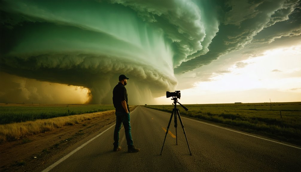
What Storm Chasers Actually Witness During a Supercell Intercept?
Once you’ve positioned ahead of a supercell, the intercept experience unfolds through a rapid sequence of distinct, visually identifiable storm features — each carrying real meteorological significance.
Your chase strategies must adapt constantly as storm structure evolves.
You’ll witness:
- Wall clouds and mesocyclones rotating beneath the updraft base, signaling tornado formation potential
- Baseball-sized hail shafts capable of catastrophic hail damage to vehicles and equipment
- Continuous lightning displays illuminating the anvil and forward-flank regions with measurable frequency
- Observational challenges requiring precise data collection positioning while maintaining safe egress routes
Storm photography demands technical discipline here — you’re balancing exposure settings against rapidly changing light and motion.
Every visual element you document contributes directly to understanding supercell dynamics, validating forecast models, and advancing the broader science of severe weather.
What Chasing Supercells Has Contributed to Real Tornado Research?
When you chase a supercell and collect in-storm pressure, temperature, and wind data, you’re feeding observational records directly into the scientific pipeline that researchers use to understand how tornadoes form.
Field intercepts from projects like VORTEX have helped isolate the boundary-layer conditions that distinguish tornado-producing supercells from non-tornadic ones, closing critical gaps that radar alone couldn’t resolve.
You’re also testing forecast models in real time, since comparing predicted storm structure and positioning against what you actually observe on the ground reveals where numerical guidance succeeds or breaks down under specific atmospheric setups.
Advancing Tornado Genesis Understanding
Before tornado research could advance meaningfully, scientists needed direct observations from inside and near active supercells—data that lab models and radar alone couldn’t supply.
Field intercepts have directly shaped what you now understand about tornado formation and storm dynamics:
- Probe deployments near mesocyclones revealed pressure drops exceeding 100 millibars inside tornadoes
- Mobile Doppler radar captured wind speed gradients that redefined dangerous inflow thresholds
- Thermodynamic measurements exposed how cold pool characteristics influence whether rotation tightens into a tornado
- Direct visual documentation helped distinguish failed tornadogenesis events from successful ones
Each data point collected during a live supercell intercept fills critical gaps that remote sensing can’t resolve.
You’re not just watching a storm—you’re extracting irreplaceable atmospheric intelligence that refines operational forecasting and saves lives.
Validating Forecast Models Observationally
Field intercepts don’t just generate raw atmospheric data—they stress-test the numerical models that forecasters rely on to issue tornado watches and warnings.
When you deploy instrumentation near a supercell’s mesocyclone, you’re capturing high-resolution observational data that reveals exactly where model output diverges from reality. Those discrepancies expose parametric weaknesses in convective schemes, boundary layer assumptions, and wind shear representations.
Model validation depends on this kind of ground-truth comparison—you can’t refine what you can’t measure directly. Each chase mission feeding real-time surface readings, mobile radar returns, and radiosonde profiles into post-event analysis tightens the gap between forecast and actual storm behavior.
Over successive field campaigns, those incremental corrections compound, producing forecast systems that give you earlier, more accurate severe weather guidance and stronger decision-making tools.
Why the Danger and Rarity of Supercells Keep Chasers in the Field?
Although supercells form on only a fraction of severe weather days, their capacity to produce violent tornadoes, baseball-sized hail, and destructive winds makes them the most technically demanding and scientifically rewarding target in storm chasing.
Their dangerous allure stems from unpredictability—no two intercepts unfold identically. You’re reading rapidly evolving radar data, adjusting routes, and making split-second decisions against rare phenomena that may never repeat.
What keeps chasers returning despite the risk:
- Tornadoes don’t form in every supercell, making each successful intercept exceptional
- Violent atmospheric behavior demands precise positioning and model interpretation
- A single storm can deliver multiple severe hazards within hours
- The rarity and raw power of supercells create an irreplaceable observational experience
Freedom-driven chasers accept calculated risk for data, documentation, and discovery.
Frequently Asked Questions
How Long Does a Typical Supercell Storm Last Before It Dissipates?
“Time flies when you’re chasing storms.” A typical supercell’s storm duration runs two to six hours. You’ll recognize its supercell characteristics through persistent rotation and organized structure, giving you maximum freedom to intercept and analyze it.
Can Supercell Storms Occur Outside of Tornado Alley in the United States?
Yes, you’ll find supercell characteristics and storm formation conditions across the entire U.S. The Southeast, Great Lakes, and High Plains regularly produce supercells when wind shear, instability, and moisture converge — giving you countless chase opportunities beyond Tornado Alley.
What Equipment Do Storm Chasers Typically Use During a Supercell Intercept?
You’ll rely on radar systems, GPS technology, communication devices, and cameras during a supercell intercept. You’ll also follow strict safety protocols while analyzing real-time atmospheric data to position yourself effectively and document the storm’s evolving structure.
How Far in Advance Can Meteorologists Predict a Supercell Storm Forming?
You can typically anticipate supercell formation 24–48 hours in advance. Prediction models analyze atmospheric instability, moisture, and wind shear, while storm dynamics data refines timing. You’ll gain precision within 6–12 hours as conditions solidify.
Have Any Storm Chasers Ever Been Killed While Chasing a Supercell?
Yes, storm chaser fatalities have occurred. You’ll find that storm chasing safety failures, including the 2013 El Reno tornado, claimed experienced chasers’ lives when unpredictable storm movements overwhelmed even data-driven positioning strategies and real-time decision-making protocols.
References
- https://www.nationalgeographic.com/environment/article/chasing-tornadoes
- https://www.netweather.tv/weather-forecasts/news/8912-storm-chasing-in-tornado-alley—all-you-need-to-know
- https://science.howstuffworks.com/nature/climate-weather/storms/storm-chaser5.htm
- https://www.reddit.com/r/stormchasing/comments/1650oq7/questions_about_how_storm_chasing_works/
- https://en.wikipedia.org/wiki/Storm_chasing
- https://www.youtube.com/watch?v=Omf4J2Vv_wM
- https://www.rmets.org/metmatters/history-storm-chasing
- https://blogs.reading.ac.uk/wcd/2011/02/11/storm-chasing/
- https://www.quincyvagell.com/chaser-guide/
- https://www.facebook.com/groups/KYNEWSWEATHER/posts/937708096407585/


