Moore, Oklahoma’s designation as tornado capital stems from its unparalleled strike frequency—194 documented tornadoes since 1890 within just 22 square miles. You’ll find no comparable U.S. city has endured two EF5-rated tornadoes (1999 and 2013) within 14 years, both carving overlapping destruction paths through identical residential corridors. The 1999 event recorded unprecedented 302-mph Doppler-measured winds, while the 2013 strike obliterated 4,500-5,000 structures and affected 13,500 residents directly. Combined damages exceeded $3 billion, with 61 fatalities across major events since 1960. The data reveals critical patterns about vulnerability, resilience, and meteorological convergence that define this community’s extraordinary exposure.
Key Takeaways
- Moore has endured over 20 documented tornadoes within its 22-square-mile boundary since the late 1800s, an unmatched frequency.
- Two EF5 tornadoes struck Moore within 14 years (1999 and 2013), producing combined damage exceeding $3 billion.
- The 1999 Bridge Creek-Moore tornado recorded the highest wind speed ever measured: 302 mph via Doppler radar.
- Moore’s location in the Oklahoma City metro creates persistent tornado corridors, with overlapping violent paths through residential areas.
- Major Moore tornadoes caused 61 fatalities and over 230 injuries from 1960-2015, reflecting extreme intensity and population density.
Unmatched Tornado Strike Frequency Since 1890
The Oklahoma City metropolitan area has recorded 194 documented tornadoes since 1890 according to National Weather Service data, with Moore accumulating an exceptionally dense concentration of strikes within this broader count.
Since 1890, the Oklahoma City metro has logged 194 confirmed tornadoes, with Moore experiencing disproportionately frequent direct strikes.
You’ll find no other U.S. city matches OKC’s metro record of over 100 direct hits during this 130-year span, per Storm Prediction Center archives. Moore’s position within this tornado corridor exposes critical infrastructure vulnerabilities that recur with each strike.
Storm Data documentation reveals touchdown events in all months except December and January, establishing year-round threat conditions. Population growth impacts complicate historical comparisons, as radar technology improvements and urban expansion have enhanced detection capabilities while simultaneously increasing property exposure.
The concentrated strike frequency, verified through damage surveys and F/EF scale ratings, demonstrates measurable atmospheric conditions favoring repeated tornado genesis in this specific geographic zone.
Two Catastrophic EF5 Tornadoes in 14 Years
Among Moore’s documented tornado strikes, two violent-scale events stand apart in meteorological significance: the May 3, 1999 Bridge Creek–Moore tornado and the May 20, 2013 Moore tornado, both rated at the highest intensity on their respective damage scales.
The 1999 F5 recorded peak winds exceeding 300 mph across a 38-mile path, killing 36 and causing $1 billion in damage. Fourteen years later, the 2013 EF5 produced 200–210 mph winds along a 14-mile track, resulting in 24 direct fatalities and $2 billion in losses.
Ground scouring, vehicle frame stripping, and structural granulation characterized both events. This unprecedented frequency of maximum-intensity tornadoes within such proximity demanded extraordinary resilience of local community members and initiated long-term reconstruction efforts spanning infrastructure modernization, building code revisions, and enhanced warning systems.
Ground Zero in America’s Tornado Alley
Positioned at the convergence of atmospheric conditions that fuel severe convection, Moore occupies central Oklahoma’s most tornado-prone corridor where warm, moist Gulf air collides with cool, dry continental systems along a persistent dryline boundary. The Oklahoma City metro’s 100+ direct tornado strikes since 1890 demonstrate this region’s unmatched vulnerability.
Moore sits where Gulf moisture meets continental air masses—a geographic convergence that has produced over a century of catastrophic tornado events.
You’ll find the Storm Prediction Center strategically positioned in nearby Norman, monitoring evolving tornado mitigation strategies while government tornado disaster response protocols remain constantly tested.
The geographic reality confronting Moore residents:
- 13,500 people directly impacted in the 2013 tornado’s 40-minute path
- 2,400 homes damaged across entire subdivisions
- 20+ documented tornadoes striking the same community since 1890
- 4,705 statewide tornadoes since 1950, concentrating repeatedly on central Oklahoma
This flat terrain amplifies both storm formation and individual preparedness responsibility.
Record-Breaking Wind Speeds and Destruction Paths
You’ll find Moore’s tornadoes consistently rank among the most violent on record, with the 1999 Bridge Creek-Moore event producing mobile Doppler-measured winds of 302 mph—the highest velocity ever recorded near Earth’s surface.
The destruction paths extend far beyond typical tornado dimensions: the 1999 tornado carved a 38-mile swath through central Oklahoma, while the 2013 EF5 reached maximum widths of 1,900 yards (1.1 miles).
These extreme parameters translate to catastrophic energy release, with both events generating damage totaling over $1 billion and demonstrating wind forces capable of obliterating entire neighborhoods within seconds.
Peak Wind Velocity Data
When mobile Doppler radar tracked the Bridge Creek–Moore F5 tornado on May 3, 1999, it documented the highest wind speeds ever recorded on Earth at 302 mph. This mobile radar wind detection breakthrough occurred through University of Oklahoma’s Doppler on Wheels technology, which measured ground-level velocities remotely—a necessity since direct instruments can’t survive violent tornadoes.
Tornado wind variation between Moore’s major events reveals critical intensity differences:
- 1999 Bridge Creek–Moore F5: 302 mph maximum winds
- 2013 Moore EF-5: 200-210 mph maximum winds
- Wind differential: 92 mph variance between events
- Destruction scope: 38-mile path of complete structural elimination in 1999
The shift from F-scale to Enhanced Fujita Scale occurred post-1999, altering classification methodology while the absolute wind speed record remains unbroken.
Path Width and Length
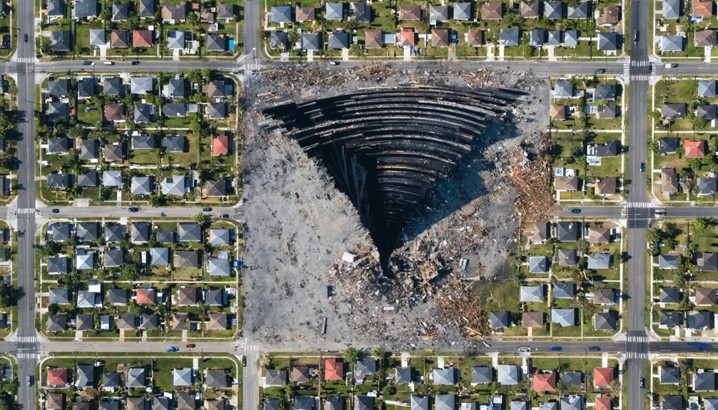
The 2013 Moore tornado carved a destruction corridor measuring 17.45 miles in length with a maximum width of 2.6 miles, establishing it as one of the widest violent tornadoes documented in the United States.
You’ll find tornado damage patterns intensified as the vortex expanded from 1.3 miles at Moore’s city limits to its peak width through densely populated neighborhoods. This dwarfed the 1999 Moore F5’s 0.8-mile width and exceeded the 2010 EF4’s 1.14-mile span.
Meteorological factors influencing path dimensions include atmospheric instability, wind shear profiles, and mesocyclone characteristics. The continuous ground scouring confirmed 17+ miles of uninterrupted contact, affecting 4,222 structures and 13,500 residents.
Understanding these measurable parameters enables you to assess risk independently without relying solely on governmental warnings.
Energy Release Measurements
Meteorologists calculated the 2013 Moore tornado’s energy release during its 40-minute lifespan using real-time atmospheric measurements, arriving at estimates ranging from 8 to over 600 times the power of the Hiroshima atomic bomb. Atmospheric energy analysis incorporated air energy measurements multiplied by storm size and duration, revealing unprecedented tornado intensity trends.
WSR-88D Doppler radar systems measured the vortex’s destructive capacity through multiple parameters:
- Peak rotational velocities of 210 mph (340 km/h) confirmed via TOKC 0.5° elevation scans
- One-mile diameter tornado debris signature detected by Twin Lakes NEXRAD
- Rapid intensification from EF0 to EF4 within just 10 minutes
- Ground scouring at EF4 strength with complete structural destruction reaching EF5 classification
These technical measurements verified the storm’s violent classification until 2025.
Billions in Property Damage Across Multiple Events
Since 1999, Moore has accumulated billions in property damage from repeated violent tornado strikes, with the 2013 EF5 and 1999 F5 events alone generating combined losses exceeding $3 billion.
You’ll find the 2013 tornado destroyed 1,150 homes in its core path, with 4,500-5,000 structures completely obliterated and insured losses reaching $2-3.5 billion. The 1999 F5 damaged or destroyed 10,000 homes across the metro area, generating $1.1 billion in total losses.
These catastrophic events created long term economic impacts, including 2-5% housing price drops during the first post-tornado year. The repeated devastation across identical neighborhoods demonstrates why effective mitigation strategies remain critical.
Ground scouring to bare soil, engineered structure failures, and complete subdivision obliteration characterize Moore’s financial toll from nature’s most powerful atmospheric phenomenon.
Deadly Toll: Fatalities and Injuries Through the Decades

Moore’s tornado history encompasses 61 documented fatalities and over 230 injuries across major events from 1960 through 2015.
The 2013 EF5 event produced 25 deaths, while the 1999 outbreak contributed 36 fatalities within the Oklahoma City metropolitan area.
You’ll find casualty rates correlate directly with tornado intensity classifications, population density along strike paths, and structural vulnerability factors such as mobile home concentrations and institutional building failures.
Major Disaster Death Counts
The 1999 Bridge Creek-Moore tornado stands as a watershed event in Oklahoma’s tornado history, claiming 36 direct fatalities and marking the deadliest U.S. tornado in over two decades at that time. You’ll find tornado fatality trends reveal stark disparities in structural vulnerability. Mobile home vulnerability proved critical—11 of the 36 deaths occurred in these structures during the outbreak.
The 2013 Moore tornado killed 24 directly, including:
- Seven children who lost their lives
- Elementary school collapse victims trapped in debris
- Residents despite improved warning systems
- Two additional indirect fatalities
Historical data shows Moore’s earlier tornadoes (1973-1991) produced zero fatalities. Pre-1925 death rates were 15 times higher than modern incidents. The 1947 Woodward tornado remains Oklahoma’s deadliest at 181 deaths, while 2013 Moore ranks ninth statewide.
Injury Numbers Over Time
Injury patterns across Moore’s tornado events reveal significant temporal variation in casualty rates, with severity correlating directly to tornado intensity classification. You’ll find that F2 tornadoes from 1951-1960 produced minimal casualties, with most reporting zero injuries except the April 1951 event’s 127 cases.
The 1999 Bridge Creek-Moore EF5 dramatically escalated casualty figures, though precise injury counts weren’t systematically documented. The 2013 EF5 definitively injured over 200 people during its 40-minute destruction path. This injury severity analysis demonstrates that enhanced emergency response protocols proved insufficient against violent tornadoes exceeding EF4 classification.
Weaker events like the 2015 EF2 injured only seven, confirming that your risk exposure increases exponentially when tornadoes reach violent intensity thresholds rather than remaining at moderate classifications.
Highest Violent Tornado Density Per Square Mile
Since 1890, Moore has recorded over 20 documented tornadoes within its compact municipal boundaries, establishing an unmatched violent tornado density per square mile among Oklahoma communities. You’re looking at a 22-square-mile zone where EF3-EF5 tornadoes strike with statistical regularity that defies national averages.
Tornado density mapping reveals central Oklahoma’s elevated violent tornado percentage, with Moore absorbing disproportionate impacts:
- Two EF5 tornadoes devastated the same town within 14 years (1999, 2013)
- Multiple violent paths overlapped, creating EF5 damage corridors through residential cores
- 13,500 residents directly affected by 2013’s 1.1-mile-wide EF5 track alone
- High-density housing amplified casualties where 200+ mph winds intersected populated zones
Urban resilience planning now prioritizes this concentration, as 97% of path populations experienced direct tornado effects during peak events.
Repeated Direct Hits Through Populated Areas
From its 1893 incorporation forward, Moore’s geographical footprint has absorbed direct tornado strikes through its populated core with remarkable consistency. The 1893 and 1894 tornadoes plowed through the town’s center, establishing a pattern that persists today.
The 1960 dual F2 event targeted northwest and central residential zones, injuring six residents. The 1999 Bridge Creek-Moore EF5 devastated the urban core, killing 36 and causing $1 billion in damage. The 2013 EF5 intensified directly over the Westmoor subdivision, affecting 13,500 people with 1.3-mile-wide destruction.
These events expose residential infrastructure vulnerabilities and create compounding societal impacts on vulnerable populations. You’ll find Moore’s tornado history reveals systematic targeting of settled areas rather than random rural strikes.
A Living Laboratory for Tornado Research and Preparedness
Moore’s recurring catastrophic tornado events have transformed the city into an intensive research site where multiple scientific institutions conduct field investigations, structural assessments, and forecasting experiments. You’ll find collaborative research initiatives involving University of Illinois engineers surveying structural damage, Texas Tech teams testing 61 shelters against debris impacts, and University of Alabama researchers examining safe room performance. Data sharing partnerships between FEMA, NSSA, and academic institutions enable thorough/exhaustive/detailed analysis of building resilience.
Moore’s tragedy-driven transformation into a living laboratory has revolutionized tornado science through unprecedented institutional collaboration and real-world testing opportunities.
These efforts directly influenced Moore becoming America’s first city adopting tornado-specific building codes, increasing residential wind endurance from 90 mph to 135 mph:
- Hazardous Weather Testbed experimentalists refine convection-allowing models during active tornado events
- Researchers deploy airborne devices measuring atmospheric energy and wind speeds
- Engineers conduct rapid-response damage surveys before cleanup destroys forensic evidence
- Storm shelter databases validate life-saving design standards
Frequently Asked Questions
Why Don’t Residents Permanently Evacuate Moore Given the Extreme Tornado Risk?
You’ll find residents stay due to community resilience and economic ties. They’ve invested in sustainable development through improved building codes and shelter systems, choosing mitigation over evacuation while accepting calculated risks inherent to tornado-prone regions.
How Do Moore’s Building Codes Compare to Other Tornado-Prone Communities?
You’ll find Moore’s codes surpass most U.S. tornado zones—mandating safe rooms in all post-2013 schools and residential structures with enhanced building material resilience. Local infrastructure updates exceed Texas and Kansas standards, enforcing 250-mph wind resistance requirements.
What Insurance Options Are Available for Moore Homeowners in High-Risk Zones?
You’ll find tornado riders with 1-5% deductibles, FEMA flood insurance coverage for storm-related water damage, and state FAIR plans when standard insurers decline. Storm shelter installation qualifies you for mandated discounts up to 35% on premiums.
Can Meteorologists Predict When Moore Will Experience Its Next Major Tornado?
Predicting tornadoes remains like reading smoke patterns—meteorologists can’t pinpoint Moore’s next major strike. However, you’ll benefit from real-time detection methods and early warning systems that typically provide 31+ minutes’ notice, empowering your independent safety decisions.
Has Moore Considered Relocating the Entire Town to a Safer Area?
No official relocation feasibility assessment has occurred. You’ll find Moore prioritized individual choice through storm shelter installations rather than government-mandated displacement. Historical data shows adaptation strategies over safer location options, respecting residents’ autonomy to remain despite tornado frequency.