Effective storm chasing forecasting starts with the SPC Day 1 outlook to establish risk levels, then layers in high-resolution models like HRRR and NAM3K for storm-scale precision. You’ll need to confirm moisture, instability, lift, and wind shear before committing to a target. Hodograph analysis sharpens your tornado potential assessment, while real-time radar tools like RadarScope keep you locked in on evolving signatures. Master each component, and your forecasting confidence builds fast.
Key Takeaways
- Start with the SPC Day 1 outlook to identify risk levels and review written discussions for forecasting criteria and reasoning.
- Confirm key atmospheric ingredients: moisture with dewpoints above 60°F, MLCAPE above 1,500 J/kg, clear lift mechanisms, and sufficient wind shear.
- Use high-resolution models like HRRR and NAM3K for storm tracking, cross-referencing model soundings with observed Skew-T diagrams.
- Analyze hodographs focusing on 0–1 km storm-relative helicity, looking for tightly curved, clockwise-turning patterns indicating strong rotational potential.
- Integrate radar tools like RadarScope and RadarOmega with NSSL ensembles and real-time soundings for precise, data-driven positioning decisions.
Start Your Storm Chase Forecast With the SPC Outlook
When planning a storm chase, start with the Storm Prediction Center’s Day 1 outlook to identify risk levels and narrow your target region. SPC outlooks categorize severe weather potential from marginal to high, giving you an immediate risk assessment without sifting through raw data first.
Start every chase day with the SPC Day 1 outlook—your fastest path from raw uncertainty to a targeted, risk-defined plan.
Don’t just read the outlook map—dig into the discussion analysis behind it. The written discussion explains the forecasting criteria driving each risk category, revealing the reasoning forecasters used for regional focus decisions.
Check outlook updates throughout the day, as storm prediction parameters shift with new model runs and observations. A marginal risk can evolve into an enhanced setup by afternoon.
Using SPC outlooks as your foundation keeps your chase planning structured, targeted, and grounded in authoritative severe weather analysis.
The Four Ingredients You Need Before Committing to a Chase
Before committing to a chase, you’ll need to confirm four atmospheric ingredients are simultaneously present: moisture, instability, lift, and wind shear. Missing even one collapses your setup.
Monitor moisture sources like Gulf of Mexico inflow, targeting dewpoints above 60°F at the surface.
Evaluate instability indicators using MLCAPE values — 1,500 J/kg signals a viable chase; anything above 2,500 J/kg demands serious attention.
Identify lift mechanisms including frontal boundaries, drylines, or upper-level divergence that’ll force air parcels upward.
Finally, assess wind shear via hodographs, prioritizing storm-relative helicity in the lowest 1 km for rotation potential.
Surface winds from the east near 15 knots, combined with 40-50 knot southwesterly flow aloft, create the directional shear tornadic supercells require.
Confirm all four before mobilizing.
How Storm Chasers Read a Hodograph for Tornado Potential
When you read a hodograph, you’re plotting wind vectors at successive atmospheric levels, with the curve’s shape and length revealing how wind speed and direction change with height.
You’ll want to focus on the 0–1 km storm-relative helicity (SRH) value, since a tightly curved, clockwise-turning hodograph in that lowest layer signals strong rotational potential for supercells.
Surface winds of roughly 15 knots from the east, combined with 40–50 knots from the southwest to west at 5,000–10,000 feet, produce the kind of directional shear that drives tornadic circulation.
Understanding Hodograph Wind Vectors
A hodograph plots wind velocity vectors across multiple atmospheric levels, giving you a visual snapshot of how wind speed and direction change with height—a critical tool for evaluating tornado potential. Each plotted point represents wind speed and direction at a specific altitude, and connecting those points creates a curve revealing wind shear characteristics throughout the atmosphere.
In hodograph analysis, you’re examining the shape, length, and curvature of that curve. A longer, curved hodograph indicates strong, directionally turning wind shear—conditions favoring supercell development and rotation.
Tight low-level curvature between 0–1 km signals enhanced tornadic potential. You’ll want surface winds near 15 knots easterly, backing to stronger southwesterly flow aloft, creating that essential curved structure.
Straight hodographs suggest weaker rotational potential, giving you cleaner go or no-go decisions before committing to a chase target.
Identifying Rotation Potential Indicators
Reading a hodograph for tornado potential comes down to three measurable indicators: storm-relative helicity (SRH), hodograph length, and low-level curvature.
These rotation indicators give you direct insight into storm dynamics before storms even develop.
Target SRH values exceeding 150 m²/s² in the 0-1 km layer—this range signals meaningful rotation potential. Values above 300 m²/s² indicate volatile atmospheric conditions worth pursuing aggressively.
Your helicity analysis should focus specifically on the lowest kilometer. That low-level curvature on the hodograph reveals how wind direction and speed change with height, directly influencing mesocyclone development.
A longer hodograph length indicates stronger bulk wind shear, supporting organized, persistent updrafts.
When SRH, curvature, and length align favorably, you’ve identified an environment capable of producing significant tornadoes.
Which Weather Models Actually Matter for Storm Chasing?
Choosing the right weather model can make or break your chase day. For storm tracking, high-resolution CAMs like the HRRR and NAM3K outperform broader models like the GFS or EURO in resolution impacts and forecast accuracy.
The HRRR updates hourly, delivering reflectivity and updraft helicity data critical for parameter evaluation. Model comparisons matter because each carries distinct model limitations—GFS handles synoptic patterns well, while HRRR excels short-range convective timing.
Hourly HRRR updates sharpen convective timing where broader models like the GFS fall short.
Leverage ensemble benefits by running multiple models simultaneously, which strengthens confidence when outputs converge. Use Pivotal Weather or weather.cod.edu for efficient data integration across platforms.
Always cross-reference model soundings via Skew-T diagrams against observed surface data. No single model owns the truth—your accuracy depends on synthesizing all available outputs critically.
Which Day-of Tools Do Storm Chasers Actually Rely On?
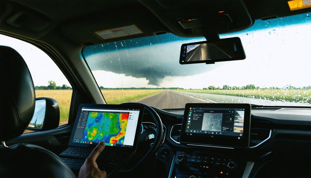
On the morning of a chase, you’ll want to run through a structured checklist: pull the latest SPC outlooks, check mesoscale analysis, review updated model runs, examine surface observations, and read local NWS forecast discussions for real-time reasoning.
Once you’re on the road, radar apps like RadarScope and RadarOmega become your primary decision-making tools, giving you live reflectivity, velocity data, and storm-relative motion to track developing cells.
You’re relying on these two layers—morning diagnostics and real-time radar—to bridge the gap between pre-chase forecasting and in-field execution.
Morning Forecast Checklist
When you wake up on a potential chase day, your first move is pulling up the SPC Day 1 outlook to confirm risk categories and read the accompanying discussion for the forecasters’ reasoning. This morning routine establishes your operational baseline before deeper data gathering begins.
Next, check the latest HRRR runs, mesoscale analysis, and surface observations to validate instability, shear, and moisture alignment. Local updates from NWS discussions sharpen your target area.
Review radiosondes and Skew-T diagrams to assess MLCAPE and storm-relative helicity values.
Simultaneously, run your equipment check on radar apps like RadarScope, confirm fuel, and finalize chase logistics with your team.
Team communication at this stage locks in contingency routes and reinforces safety protocols, ensuring everyone operates from identical, current situational awareness before wheels roll.
Real-Time Radar Apps
Once wheels roll, 2 radar apps dominate the field: RadarScope and RadarOmega. Both deliver professional-grade radar app features, giving you dual-polarization data, velocity scans, and rotation alerts without filtering critical information.
RadarScope excels in storm cell identification through clean, responsive user interface design that keeps raw data front and center. You’ll track hook echoes, mesocyclone signatures, and hail cores with precision.
RadarOmega adds deeper interrogation tools, letting you analyze tilt sequences rapidly while driving.
Real time tracking between both apps means you’re never working from stale data during rapidly evolving situations. Toggle between base reflectivity and storm-relative velocity to confirm rotation development.
Either app puts actionable intelligence directly in your hands, letting you make independent positioning decisions without depending on outside communication.
Advanced Forecasting: NSSL Ensembles, Soundings, and Nowcasting
As you move deeper into the chase day, advanced tools like NSSL ensembles, real time soundings, and nowcasting techniques sharpen your decision-making beyond what standard model runs can offer.
NSSL ensembles generate short-range severe weather probabilities using current radar data, giving you a 0-1 hour predictive edge. Upper air soundings reveal real-time atmospheric profiles—CAPE, shear, and hodograph structure—helping you differentiate adjacent target areas with precision.
Nowcasting techniques integrate satellite trends, surface observations, and advanced radar data to anticipate storm initiation timing and evolution. You’re not guessing; you’re synthesizing live data streams into actionable decisions.
Reviewing local NWS discussions alongside these tools adds operational context. Together, these methods let you position efficiently, respond dynamically, and chase with calculated confidence rather than reactive uncertainty.
Frequently Asked Questions
How Do Storm Chasers Stay Safe While Monitoring Severe Weather Conditions?
Like a hawk reading wind currents, you’ll master safety protocols by conducting real-time risk assessment, monitoring RadarScope, tracking storm motion, maintaining escape routes, and trusting SPC outlooks to keep you free yet protected.
What Equipment Do Storm Chasers Typically Carry in Their Vehicles?
You’ll need RadarScope for storm tracking, a laptop for data analysis, GPS, dash cameras, and weather stations. These tools let you monitor real-time atmospheric shifts, ensuring you’re equipped for precise, independent decision-making in volatile conditions.
How Does Terrain Affect Storm Chasing Decisions and Route Planning?
You’ll factor terrain analysis into route optimization by studying local geography’s impact on weather patterns. Hills obstruct radar visibility, valleys channel winds unpredictably, and road networks limit escape options, so you’ve got to plan accordingly.
Can Beginners Effectively Use Composite Parameters Without Advanced Meteorology Training?
Yes, you can effectively use composite parameters as beginner strategies without advanced training. Tools like SPC’s SPC outlooks simplify data interpretation, letting you assess tornado risk by reading pre-calculated indices that combine CAPE, shear, and helicity automatically.
How Do Chasers Coordinate With Emergency Management During Active Tornado Events?
“Many hands make light work”—you’ll relay real-time tornado communication protocols directly to local emergency management via ham radio or spotter networks. You’re following chaser safety guidelines while transmitting GPS position, tornado direction, and movement data precisely.
References
- https://www.wiu.edu/SevereWeather/images/presentations/How_to_Effectively_Storm_Chase.pdf
- https://www.tornadotitans.com/p/five-charts-thatll-have-you-forecasting
- http://www.stormeyes.org/tornado/chasing/FAQ/
- https://www.madscitech.org/scg/intro.html
- https://www.nssl.noaa.gov/education/svrwx101/thunderstorms/forecasting/
- https://www.stormchasingusa.com/blog/learning-the-basics-about-tornadic-storm-forecasting/
- https://www.stormtours.com/information/forecasting-explained/
- https://www.youtube.com/watch?v=VkpadCUGaVA
- https://www.weather.gov/media/bis/Weather_Spotter_Field_Guide.pdf


