Mastering storm chasing across seasons means adapting your targets, gear, and forecasting approach to shifting atmospheric patterns. In spring, you’ll chase supercells across the Great Plains using CAPE values above 2,000 J/kg and strong wind shear. Summer demands tighter positioning for fast-firing pulse storms, while fall shifts your focus south toward boundary-driven events. Pre-season gear checks, real-time RadarScope monitoring, and escape route planning keep you alive and productive. The full breakdown ahead sharpens every layer of your seasonal strategy.
Key Takeaways
- Spring storm chasing peaks April–June on the Great Plains, requiring daily SPC outlooks and HRRR model monitoring for optimal supercell targeting.
- Summer chasing demands flexible, aggressive positioning as pulse thunderstorms fire quickly, requiring real-time radar analysis and surface boundary monitoring.
- Fall chasers should reposition early, prioritize radar reliance, and target southern Plains due to unpredictable storm acceleration and reduced daylight.
- Essential gear includes GPS, RadarScope, DSLR camera, weather-rated helmet, and printed maps for areas with poor cell coverage.
- Always identify two escape routes before positioning, prioritizing paved south or east roads while avoiding dead-ends near mesocyclones.
Chase Spring Storms in Prime Tornado Alley Season
Spring, particularly April through June, delivers the highest concentration of supercells and tornadoes across the Great Plains, making it the most productive window for structured storm chasing.
You’ll find elevated CAPE values and strong directional wind shear combining to fuel organized convection, accelerating tornado formation and producing well-defined storm structure.
Monitor SPC convective outlooks daily and cross-reference high-resolution models like the HRRR to pinpoint your target area 12–24 hours out.
Track SPC outlooks and HRRR model data daily to lock in your target zone well before storm initiation.
Position yourself south or southeast of developing supercells, where wall clouds and mesocyclones remain visible and unobstructed by precipitation.
Avoid core-punching at all costs—it compromises both safety and observation quality.
This season rewards disciplined forecasting, precise positioning, and rapid decision-making, giving you maximum freedom to intercept and document significant severe weather events efficiently.
How Spring, Summer, and Fall Demand Different Storm Chasing Tactics
Each season demands a distinct tactical approach: spring’s April–June window delivers peak CAPE, organized wind shear, and the highest supercell frequency across the Great Plains, making it your highest-probability period for significant tornadoes.
As summer arrives, you’ll shift targets northward to the upper Plains and Rockies, where pulse thunderstorms dominate and severe-weather density drops, requiring tighter real-time radar analysis to intercept isolated events.
Fall reintroduces organized severe weather across the southern Plains and lower Mississippi Valley, where strong wind events and scattered tornadoes demand renewed attention to SPC outlooks and meso-scale discussions as shear patterns rebuild.
Spring’s Peak Severe Season
When it comes to storm chasing, no season demands more preparation or delivers more opportunity than spring, particularly the April–June window across the Great Plains.
During this peak window, severe weather patterns intensify as warm Gulf moisture collides with cold continental air masses, generating elevated CAPE values and strong directional wind shear — ideal conditions for tornado formation.
You’ll want to monitor SPC convective outlooks daily, tracking mesoscale discussions as they emerge.
High-resolution models like the HRRR help you pinpoint target zones hours ahead.
Position yourself south or southeast of developing supercells, maintaining clear escape routes and maximizing visibility.
Spring rewards disciplined forecasters who commit early to a target and adjust based on real-time radar — not those who hesitate or chase blindly across unfamiliar terrain.
Summer’s Shifting Storm Targets
As spring’s supercell parade winds down, summer shifts your targeting considerably — away from the southern Great Plains and toward the northern Plains and Rockies, where pulse thunderstorms dominate.
These summer storms fire quickly, lack persistent organization, and dissipate fast, so you’ll need tighter, more flexible positioning strategies.
Monitor CAPE values and surface boundaries daily, since localized severe events can erupt within narrow windows — sometimes under two hours.
Unlike spring’s sustained supercell setups, summer convection often concentrates along terrain-forced boundaries in Montana, Wyoming, and the Dakotas.
You’ll want to reposition frequently, prioritizing real-time radar over morning model guidance.
Severe weather density drops considerably compared to spring, so maximizing each chase day requires aggressive, data-driven targeting and a willingness to cover greater distances for fewer, faster-moving opportunities.
Fall’s Secondary Weather Risks
Fall delivers a secondary severe weather peak that demands a significant geographic and tactical pivot — your target zone shifts south toward the southern Plains and lower Mississippi Valley, where stronger wind events and scattered tornadoes replace spring’s classic supercell setups.
Fall storm characteristics differ meaningfully: shear profiles tighten, daylight shrinks, and storms often fire at night, complicating visual confirmation. You’ll need to lean harder on radar than eyeballing structure.
For tornado safety tips, reposition earlier than you think necessary — fall storms can accelerate unpredictably, and escape routes through dense southern terrain aren’t forgiving.
Monitor SPC outlooks aggressively, prioritize surface boundary placement, and respect fast-moving linear systems that don’t telegraph rotation clearly. Your margins tighten considerably compared to spring’s more forgiving, open-terrain chases.
Build Your Storm Chasing Gear Kit Before the Season Starts
Gear up before the season hits—waiting until storms are already firing means scrambling for equipment when you should be analyzing SPC outlooks. Your gear essentials include a GPS unit, RadarScope-enabled device, DSLR camera, sturdy tripod, and spare batteries.
Don’t overlook safety equipment: a weather-rated helmet, first aid kit, and emergency escape tool belong in every chase vehicle. Mount a dash camera to document positioning decisions and post-chase reviews. Keep a printed map as a GPS backup—cell coverage fails in remote Plains corridors.
Stock your vehicle with water, fuel reserves, and jumper cables before deploying. Pre-season assembly lets you test every component under zero-pressure conditions, ensuring nothing fails when a supercell develops and your escape routes demand split-second execution.
Read the Sky: SPC Outlooks, CAPE, and Wind Shear
Three core tools—SPC outlooks, CAPE values, and wind shear data—form the backbone of any serious pre-chase forecast analysis.
Master SPC outlooks analysis by checking convective outlooks and mesoscale discussions each morning; they’ll define your target region before you leave.
Layer in CAPE interpretation next—values exceeding 2,000 J/kg signal strong instability and heighten severe weather patterns.
Wind shear significance can’t be ignored: directional and speed shear between surface and 500mb organizes storms into discrete supercells rather than chaotic clusters.
Convective parameter assessment ties these elements together, letting you evaluate atmospheric conditions evaluation holistically.
Use forecasting tools overview platforms like College of DuPage’s HRRR models for storm structure recognition at fine resolution.
Cross-reference everything, trust the data, and you’ll position yourself where freedom and precision intersect.
Stay Safe With Smart Positioning and Escape Routes
When positioning your vehicle, you’ll want to stay south or east of active storms, since supercells typically track from southwest to northeast and place the most dangerous circulation north and west of your location.
Always identify multiple escape routes before a storm closes in, as heavy rain, flash flooding, or an abrupt shift in storm motion can instantly cut off a single exit.
Never core-punch—driving through a storm’s rain-wrapped interior spikes your exposure to flash floods, large hail, and tornadoes that form with little to no visual warning.
Storm Positioning Best Practices
Staying alive during a storm chase hinges on one non-negotiable rule: you’ll want your vehicle positioned to the south or southeast of any active supercell. Most supercells track southwest to northeast, so southern positioning keeps you ahead of the primary threat zone while maintaining clear sightlines to the wall cloud and any developing tornadoes.
Effective storm tracking demands you read real-time radar and surface weather patterns simultaneously. Staying east of the rain-wrapped core eliminates core-punching risks — flash flooding, large hail, and sudden tornado emergence.
Always identify two or three escape routes before committing to any position. Weather patterns shift rapidly, and a single blocked road can eliminate every margin you’ve built. Prioritize paved roads running south or east, and never let complacency override your pre-planned exit strategy.
Multiple Escape Routes Matter
Escape routes aren’t an afterthought — they’re built into your positioning decision before you ever stop the vehicle.
Before parking, identify at least two viable exit vectors — typically paved roads running south or east — that let you outpace a storm moving northeast at 30–50 mph.
Cross-reference your RadarScope data with local road grids; dirt roads flood fast and compromise your escape route planning under heavy precipitation.
Note bridge underpasses, elevated terrain, and storm shelter options along each corridor before conditions deteriorate.
If a road dead-ends or curves back toward the mesocyclone, reject that position entirely.
Reassess routes every few minutes as storm motion shifts.
Freedom to chase aggressively depends entirely on your ability to exit cleanly — lock those routes down first.
Avoiding Dangerous Core Punching
Core punching — driving through a storm’s heavy rain core — is one of the most preventable yet persistently fatal mistakes in storm chasing.
When you breach that curtain of precipitation, you’re surrendering visual contact, exposing yourself to baseball-sized hail, flash flooding, and tornadoes you can’t see forming until impact is seconds away.
Smart storm navigation strategies demand you stay southeast of active circulation, where visibility remains clear and escape vectors stay open.
Your core safety techniques should include real-time RadarScope monitoring, identifying reflectivity gradients exceeding 50 dBZ as hard boundaries you won’t cross.
If re-positioning requires passing north of a storm, abort and reset.
You own your route choices — don’t let target fixation strip that freedom.
Discipline here consistently separates experienced chasers from statistics.
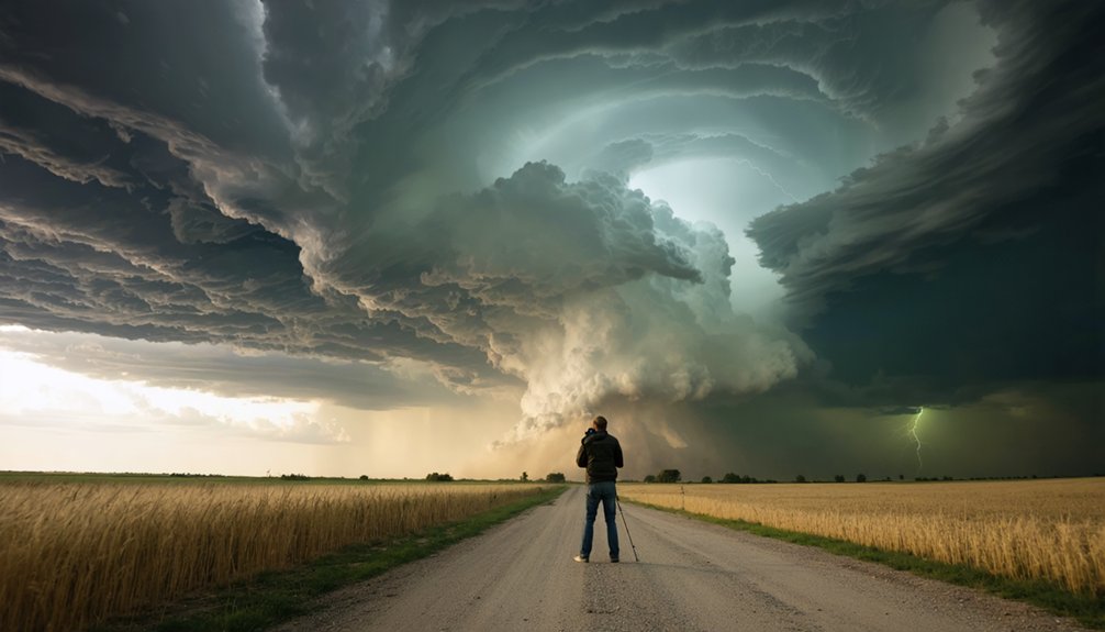
Capture Stunning Storm Chasing Photos Without Getting Killed
Capturing dramatic storm images demands that you balance aggressive positioning with disciplined safety margins.
For storm photography, station yourself east or southeast of the circulation, where wall clouds remain visible and rain wraps minimally. Deploy your DSLR on a tripod, set apertures near f/8, ISO between 200–800, and expose 5–15 seconds to capture lightning strikes cleanly.
Real-time RadarScope data lets you confirm your safe observation distance from the mesocyclone’s core. Never sacrifice your escape route for a better angle—pre-identify two exits before you stop.
Continuously scan overhead for rapid wall cloud descent or rear-flank downdraft surges even while shooting. Freedom in chasing means making deliberate, informed choices, not reckless ones.
Disciplined positioning consistently yields superior images and keeps you alive for the next chase.
Use the Off-Season to Sharpen Your Storm Chasing Forecasting Skills

The 3 quietest months of your chase calendar are your most underrated forecasting resource. Off season training sharpens your edge before April’s first supercell fires. Don’t waste that window.
Prioritize these forecasting techniques:
- Analyze SPC storm reports from the previous season, cross-referencing tornado counts by month and region to refine your targeting logic.
- Revisit convective parameters—CAPE gradients, wind shear profiles, and hodograph shapes—using College of DuPage archived model data.
- Engage StormTrack.org’s introductory subforums, where hundreds of threads dissect real chase scenarios and forecast busts.
You’re not waiting for storm season—you’re engineering a competitive advantage.
Every hour spent reviewing data now translates directly into sharper, faster targeting decisions when storms fire.
Frequently Asked Questions
Can Beginners Join Storm Chasing Tours Across Canada During Summer Months?
You’ll chase the wildest storms of your life joining Canadian tours from May–August! Reputable beginner tours teach you storm chasing basics across southern prairies while experienced guides guarantee summer safety throughout Manitoba, Saskatchewan, and Alberta.
Are There Legal Permits Required for Storm Chasing in Certain U.S. States?
You don’t typically need state-specific permits for storm chasing, as no formal storm chasing regulations exist across U.S. states. However, you must follow standard traffic laws and avoid obstructing emergency responders during active severe weather events.
How Do Experienced Chasers Handle Mental Fatigue During Long Multi-Day Chase Trips?
Like a marathon runner pacing themselves, you’ll build mental resilience by rotating drivers, logging chase data systematically, scheduling rest stops, and practicing fatigue management through structured sleep cycles between multi-day deployments.
What Insurance Coverage Do Storm Chasers Typically Need for Their Vehicles?
You’ll need vehicle liability and extensive coverage at minimum. Extensive protects against hail, flooding, and storm damage—critical risks you face daily. Verify your policy covers business use, as standard personal auto often excludes professional chasing activities.
How Do Storm Chasers Coordinate Safely With Local Emergency Management Officials?
You’ll coordinate by registering with SpotterNetwork.org, following established safety protocols, and maintaining emergency communication via ham radio or mobile apps, ensuring you’re sharing real-time storm data with local emergency management officials efficiently.
References
- http://www.stormeyes.org/tornado/chasing/FAQ/
- https://www.youtube.com/watch?v=w-5nJ61umeA
- https://www.youtube.com/watch?v=dCGFK8JI-mU
- https://www.youtube.com/watch?v=m2eGsq13iz8
- https://www.reddit.com/r/stormchasing/comments/1qh9kur/wanting_to_try_to_go_storm_chasing_this/
- https://www.livingskytours.com/storm-chasing-guide/
- https://www.youtube.com/watch?v=uGw057nHb6w
- https://blog.daytripto.com/storm-chasing-101-all-you-need-to-know-about-tornado-hunting-tours/
- https://www.stormchasingusa.com/when-to-go/
- https://www.stormchasingusa.com/where-do-you-chase/


