The rear flank downdraft (RFD) is a descending current of air that wraps around the rear of a supercell’s mesocyclone, driven by pressure perturbations, evaporative cooling, and dry air intrusion. You’ll find it marked visually by a clear slot and radar-confirmed hook echo. It fuels low-level convergence, intensifies rotation, and directly accelerates tornadogenesis. Understanding whether you’re dealing with a dry or wet RFD changes everything about tornado risk assessment—and there’s considerably more to unpack.
Key Takeaways
- The RFD forms when storm-scale pressure perturbations force mid-level air downward, enhanced by evaporative cooling, hail melting, and dry air intrusion.
- A clear slot, a cloud-free notch wrapping around the updraft base, visually identifies descending RFD air eroding surrounding cloud cover.
- Dry RFDs favor tornadogenesis by enhancing low-level buoyancy and reducing CIN, while wet RFDs containing rain and hail inhibit tornado formation.
- The hook echo on radar traces precipitation wrapping around the mesocyclone, with tightening rotation indicating increased tornado risk.
- RFD intensifies low-level convergence and mesocyclone rotation, making its thermodynamic characteristics critical for assessing supercell tornado potential.
What Is the Rear Flank Downdraft in a Supercell?
When you examine a supercell thunderstorm, one of its most structurally significant features is the rear flank downdraft (RFD) — a descending air current positioned on the back side of the storm’s rotating updraft, or mesocyclone. It’s a recognized structural element that directly influences storm intensity, shaping how a supercell evolves and whether it produces a tornado.
The RFD commonly wraps around the updraft base, generating a visible clear slot and a hook-like radar signature. It’s distinctly different from the forward flank downdraft (FFD), which tends to be cooler and rain-cooled.
Climate influence plays a role here too, as environmental moisture and thermodynamic conditions affect RFD characteristics. Understanding what the RFD is gives you a precise foundation for analyzing supercell behavior and tornado potential.
How the RFD Forms Inside a Supercell Thunderstorm
When you examine RFD formation, two mechanisms stand out: storm-scale pressure perturbations and evaporative cooling.
Vertical pressure-gradient forces within the rotating supercell push mid-level environmental air downward around the mesocyclone, initiating descent on the storm’s rear flank.
Simultaneously, evaporative cooling, hail melting, and intrusion of drier air add negative buoyancy, accelerating that sinking air toward the surface.
Pressure-Driven Descent Mechanisms
Inside a supercell’s rotating updraft, storm-scale pressure perturbations force mid-level environmental air downward along the rear flank, initiating the RFD. You can trace this descent directly to vertical pressure-gradient perturbations embedded within mesocyclone dynamics—the rotating structure generates localized low pressure aloft and elevated pressure below, mechanically driving air downward.
Storm thermodynamics amplify this process: evaporative cooling, hail melting, and drier air intrusion all generate negative buoyancy, accelerating the descent further. As that air compresses during its descent, it warms and dries, producing the RFD’s characteristic thermodynamic signature.
Understanding these pressure-driven mechanisms gives you a clearer picture of why the RFD develops consistently on the storm’s rear flank and why it remains structurally distinct from other downdraft regions within the supercell.
Evaporative Cooling and Sinking
Evaporative cooling drives much of the RFD’s negative buoyancy as dry mid-level air entrains into the storm’s precipitation cascade. When hydrometeors evaporate, they extract latent heat from surrounding air, reducing buoyancy and forcing descent.
Microphysical processes—including hail melting and raindrop evaporation—amplify this cooling effect, generating negatively buoyant parcels that accelerate downward through the rear flank region.
You’ll notice storm scale dynamics compound this mechanism: sinking air compresses adiabatically, partially offsetting evaporative cooling and producing a characteristically warm, dry RFD signature at the surface.
This thermodynamic contrast distinguishes the RFD from the colder, rain-saturated forward flank downdraft.
The resulting negative buoyancy gradient between the RFD and storm inflow directly influences low-level convergence patterns, shaping whether conditions support tornadogenesis or remain nontornadic.
Clear Slots, Hook Echoes, and the Visual Fingerprints of the RFD
When you observe a supercell, two signatures immediately flag the RFD’s presence: the clear slot and the hook echo.
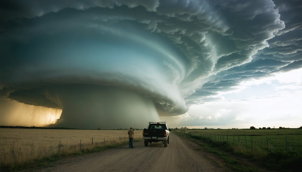
The clear slot forms as descending, drying RFD air erodes cloud cover, producing a visually distinct cloud-free notch wrapping around the updraft base.
On radar, you’ll see the hook echo as precipitation wraps cyclonically around the mesocyclone, a direct structural consequence of the RFD’s circulation tightening around the storm’s rotating core.
Identifying the Clear Slot
As the RFD descends and dries the surrounding air, it carves out a recognizable cloud-free notch known as the clear slot—one of the most reliable visual indicators that a supercell is in or approaching a tornadic phase. You’ll typically spot it wrapping around the rear of the updraft base, reflecting the broader atmospheric dynamics driving air downward into the mesocyclone.
Within the overall storm structure, the clear slot often appears alongside a horseshoe-shaped cloud base, with the RFD pushing beneath the rotating updraft. When you observe this feature tightening and expanding, low-level convergence is likely intensifying.
Recognizing the clear slot early gives you a critical timing advantage—it signals that tornadogenesis conditions are actively developing and that the storm’s most dangerous phase may be imminent.
Hook Echo Radar Signatures
While the clear slot gives you a visual confirmation of the RFD’s activity, radar translates that same process into a quantifiable signature: the hook echo. Precipitation wraps cyclonically around the mesocyclone, tracing the rotational boundary between the RFD and storm inflow patterns.
That hook-shaped appendage on reflectivity scans marks the precipitation-laden RFD curling toward the updraft base.
You’ll want to correlate hook echo structure with velocity data. Strong rotational couplets embedded within mesocyclone dynamics, paired with a well-defined hook, markedly increase tornado probability assessments.
A tight, compact hook typically signals intense low-level rotation. Broader, diffuse hooks often indicate weaker mesocyclone organization. Recognizing these distinctions lets you interpret radar output accurately, giving you actionable intelligence rather than guesswork when evaluating a supercell’s tornadic potential.
Dry RFD vs. Wet RFD: What’s the Difference?
Not all RFDs behave the same way, and the distinction between a dry RFD and a wet RFD carries considerable operational and tornadogenesis implications.
A dry RFD typically exhibits warmer RFD temperature and lower RFD moisture, making it thermodynamically closer to storm inflow. This profile enhances low-level buoyancy, reduces CIN, and supports tornadogenesis more effectively.
You’ll also get better visibility, since the descending air clears precipitation and produces a defined clear slot.
A wet RFD, common in high-precipitation supercells, carries falling rain and hail into the rear-flank region. This reduces visibility dramatically and introduces cooler, more stable air at the surface.
While wet RFDs can still produce damaging winds and large hail, they’re generally less favorable for tornado development and make ground-truth storm spotting notably more dangerous.
The RFD’s Role in Tornado Formation

The RFD isn’t just a structural curiosity—it’s a primary driver of tornadogenesis in supercell thunderstorms. When RFD air feeds into the low-level mesocyclone, it enhances surface convergence and tightens existing rotation, directly accelerating tornado development.
Storm energetics play a critical role here: as near-surface RFD buoyancy increases, CAPE rises, and CIN decreases, tornado likelihood, intensity, and longevity all improve measurably.
Tornadic supercells consistently show RFDs that are thermodynamically closer to storm inflow than nontornadic counterparts.
Lightning interactions within the mesocyclone region can signal rapid intensification of this process, offering you an additional real-time indicator of evolving storm dynamics.
Understanding these mechanisms gives you the analytical framework to assess tornadogenesis potential accurately, rather than relying solely on visual cues or basic radar interpretation.
How Storm Spotters Use the RFD to Find the Tornado Zone
Storm spotters rely on the RFD’s visual and structural signatures to pinpoint the most likely tornado-production zone within a supercell. You’ll focus on the clear slot—a cloud-free notch where descending, drying RFD air becomes visible—and track the horseshoe-shaped updraft base wrapping around it.
The clear slot is your compass—where RFD air carves the sky, tornadoes are born.
The northern edge of that horseshoe marks your primary target zone. Standard storm chase techniques position you south or southeast of the mesocyclone, keeping the clear slot in direct view while maintaining an escape route.
You’ll also monitor the RFD gust front’s surface push, which signals intensifying low-level convergence and imminent rotation tightening.
Lightning safety remains non-negotiable; elevated storm chase exposure increases strike risk considerably. Never drive into a wet RFD—hail, reduced visibility, and damaging winds create conditions that compromise both safety and situational awareness.
How the RFD Informs Tornado Warnings and Spotting Safety
Because the RFD directly marks the likely tornado-production zone, its radar and visual signatures drive real-time warning decisions at operational forecast offices. Meteorologists integrate hook-echo structure, atmospheric shear profiles, and microburst dynamics to assess tornado probability rapidly.
You can use these same indicators to stay safe in the field:
- Monitor the clear slot; its appearance signals active RFD descent and imminent tornadogenesis potential
- Track the RFD gust front on radar, since enhanced low-level convergence often precedes tornado touchdown
- Never penetrate a wet RFD—hail, damaging winds, and microburst dynamics create life-threatening conditions
- Assess atmospheric shear data alongside hook-echo tightening to gauge tornado intensity and longevity
Respecting these signatures keeps you informed and positioned outside the highest-risk zone during rapidly evolving supercell events.
Frequently Asked Questions
Can the RFD Occur in Non-Supercell Thunderstorms or Other Storm Types?
Like a fingerprint unique to one hand, RFD mechanisms are distinctly tied to supercell storm type distinctions. You won’t find true RFDs in ordinary thunderstorms—they require a mesocyclone’s rotating updraft to develop properly.
How Fast Can RFD Winds Typically Travel at the Surface?
You’ll find RFD surface wind speeds typically ranging from 40 to over 100 mph. Downdraft impact varies by storm intensity, but you can expect significant gusty outflow that enhances low-level convergence and supports tornadogenesis near the mesocyclone.
Does the RFD Produce Any Measurable Temperature Drop at Ground Level?
Like a desert breeze turning surprisingly cool, the RFD’s temperature impact at ground level can actually warm rather than cool. You’ll often measure a dry, warm signature—ground level cooling isn’t the RFD’s typical thermodynamic fingerprint.
Can Animals or Wildlife Sense the RFD Before Humans Detect It Visually?
Yes, wildlife sensitivity often precedes your visual detection. Animal behavior—restlessness, flight, or burrowing—can signal RFD-driven pressure drops, infrasound shifts, and electrostatic changes before you’d spot any clear slot or hook echo formation.
Has RFD Research Changed How Meteorologists Design Tornado Warning Systems Historically?
Over 80% of violent tornadoes link to RFDs—yes, RFD research has revolutionized tornado warning evolution. You’ve gained faster, more accurate RFD detection methods, cutting warning lead times and empowering you to act independently before disaster strikes.
References
- https://www.weather.gov/spotterguide/supercell2
- https://en.wikipedia.org/wiki/Rear_flank_downdraft
- https://journals.ametsoc.org/view/journals/mwre/136/7/2007mwr2285.1.pdf
- https://stormtrack.org/threads/rear-flank-downdraft.16841/
- https://en.wikipedia.org/wiki/Supercell
- https://www.youtube.com/watch?v=q5WzYRwhE0g
- https://www.weather.gov/media/lmk/soo/Supercell_Structure.pdf
- https://www.youtube.com/watch?v=BdIFXFqpnU8
- https://journals.ametsoc.org/view/journals/mwre/135/1/mwr3288.1.xml



