Storm chasers aren’t just chasing thrills — you’re looking at a complex mix of scientific curiosity, visual storytelling, and atmospheric research driving their pursuits. They position themselves near violent supercells to capture pressure gradients, wind shear profiles, and tornado genesis data that stationary infrastructure simply can’t replicate. The adrenaline rush merges with genuine meteorological purpose, producing field measurements that refine forecasting accuracy and save lives. There’s far more precision behind every chase decision than most people realize.
Key Takeaways
- Storm chasers are motivated by a passion for visual storytelling, documenting extreme weather through compelling photography and real-time footage.
- The adrenaline rush of extreme weather proximity drives chasers to seek high-risk, thrilling experiences in dangerous atmospheric conditions.
- Deep atmospheric curiosity pushes chasers to witness rare phenomena, fostering a profound connection with nature’s most powerful events.
- Scientific purpose motivates many chasers to collect critical field data, improving tornado forecasting accuracy and weather warning systems.
- Community engagement and educational outreach inspire chasers to share their experiences, making atmospheric science accessible to the general public.
The Core Motivations That Drive Storm Chasers
Storm chasing draws people in for a mix of reasons that range from pure curiosity to deliberate scientific purpose.
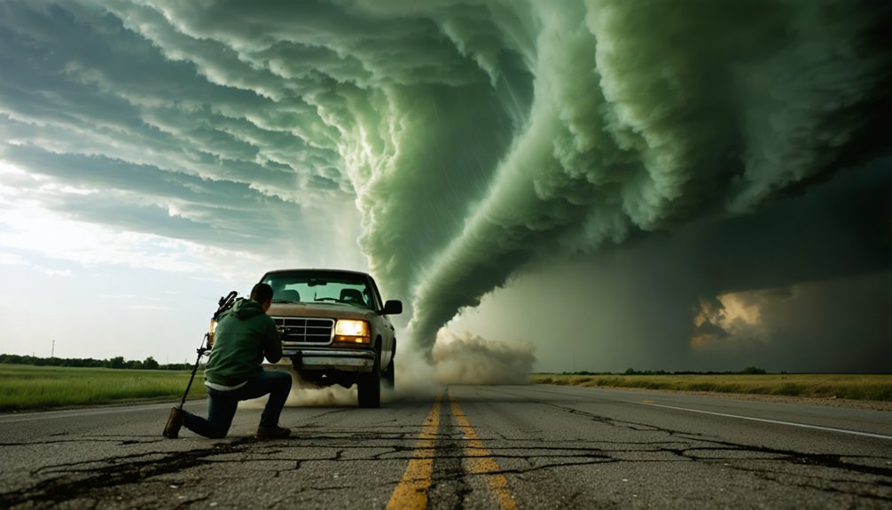
Your passion pursuit might center on visual storytelling, capturing towering cumulonimbus structures and lightning sequences for documentation or media.
Maybe it’s the adrenaline rush of positioning near a wall cloud as rotation tightens overhead.
For others, atmospheric curiosity drives the chase — a need to witness rare convective processes firsthand.
You experience awe moments that reinforce a deep nature connection, watching storm beauty evolve across an open horizon.
Thrill exploration and adventure seeking fuel high-risk positioning decisions, while the emotional experience of standing beneath a violent supercell creates a personal meaning no static image fully conveys.
Each motivation shapes how you approach, intercept, and document extreme weather.
The Storm Structures Storm Chasers Most Want to See
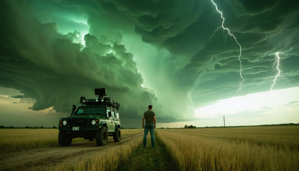
When you chase storms, the structures you’re targeting aren’t random—towering cumulonimbus formations signal explosive instability, with cloud tops often exceeding 50,000 feet and updraft speeds surpassing 100 mph.
Beneath them, rotating wall clouds indicate a mesocyclone’s tightening circulation, serving as a direct precursor to tornado development and a critical visual marker you can’t afford to misread.
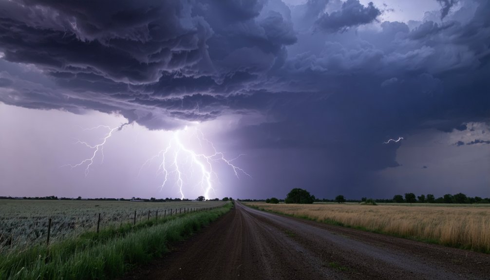
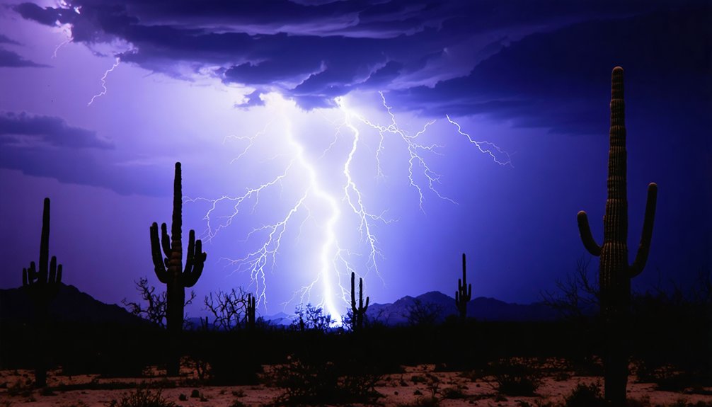
Dramatic lightning displays, sometimes producing thousands of ground strikes per hour, add another data layer, often correlating with convective intensity and storm-cell reorganization.
Towering Cumulonimbus Formations
Few atmospheric structures command as much attention from chasers as the towering cumulonimbus, a convective giant that can punch through the troposphere and breach the tropopause at altitudes exceeding 60,000 feet.
These cumulonimbus characteristics make them unmistakable targets: anvil-shaped tops, glaciated outflow, overshooting domes, and violent updraft cores exceeding 150 mph.
You’re drawn to them because they represent the full expression of atmospheric instability, where CAPE values above 3,000 J/kg fuel explosive cloud formation within minutes.
The visual contrast between the dark, rotating base and the luminous anvil creates conditions no controlled environment can replicate.
Identifying a mature cumulonimbus early lets you position strategically, maximizing observation time while maintaining viable escape corridors as the storm evolves through its organizational stages.
Rotating Wall Clouds
Beneath the towering cumulonimbus you’ve been tracking, a localized lowering often begins to form along the rain-free base — this is the rotating wall cloud, and it’s the structure chasers prioritize above nearly everything else.
Rotating wall clouds signal intense mesocyclone activity, where strong inflow and rotating updrafts compress the lifting condensation level several hundred feet below the surrounding base. You’re watching storm dynamics in their most concentrated form.
Persistent rotation, rapid vertical motion, and ragged edges indicate a mesocyclone that’s tightening — potentially priming conditions for tornado development.
You’ll want a clear southern or southeastern vantage point to assess rotation speed, inflow bands, and any pendant features extending downward.
Every visual cue matters here, and disciplined positioning keeps you informed without surrendering your escape route.
Dramatic Lightning Displays
Lightning transforms a severe thunderstorm into something visually overwhelming, and you’ll recognize its most dramatic forms long before you understand exactly what’s producing them. Crawlers spread horizontally across anvil bases, while ground-to-cloud channels discharge in milliseconds with return strokes exceeding 50,000°F.
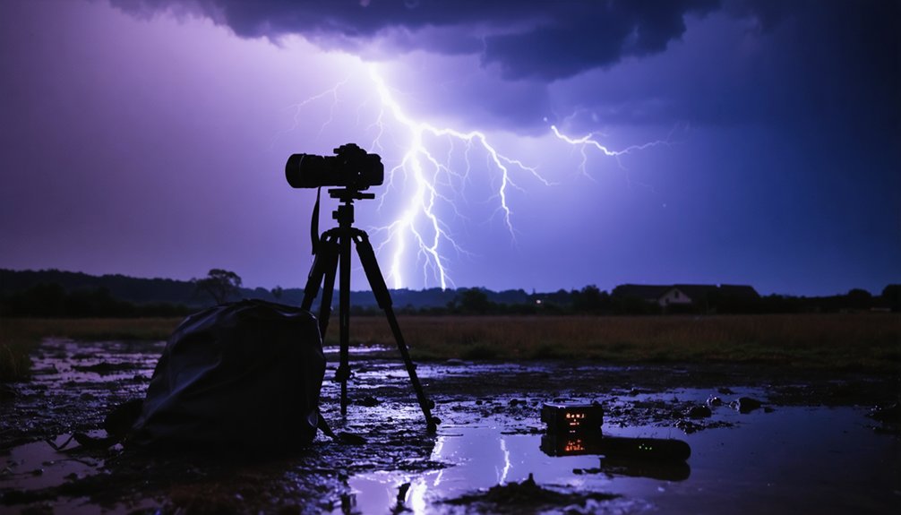
For lightning photography, positioning relative to storm structure matters more than proximity. You’ll want a wide foreground, clear sightlines, and fast shutter control to isolate individual channels against turbulent skies.
Storm aesthetics peak when multiple discharge types occur simultaneously — intracloud flashes illuminating precipitation cores while positive ground strikes ignite the forward flanks. These events aren’t random. They reflect charge separation driven by updraft velocity and mixed-phase particle collisions.
Understanding that mechanism sharpens both your composition decisions and your ability to predict where the next strike originates.
How Storm Chasers Choose Their Targets
Choosing the right target is one of the most analytically demanding parts of storm chasing. Your Target Selection Strategies begin hours before you leave, pulling Storm Prediction Models, high-resolution soundings, and mesoscale discussions to identify favorable setups.
Target selection isn’t guesswork — it’s hours of model analysis, soundings, and mesoscale data before you ever leave the driveway.
You’ll apply Radar Interpretation Techniques to assess storm mode, rotation signatures, and cell organization. Environmental Factors Assessment means scrutinizing CAPE values, wind shear profiles, and moisture boundaries that signal explosive convective potential.
You’re not working alone either — Chaser Networking Insights from trusted contacts in the field sharpen your situational awareness in real time.
Route Planning Essentials demand you map escape corridors and fuel stops before committing. Real-time Communication Tools — mobile radar apps, spotter networks, and radio feeds — keep your decisions sharp and your options open as conditions evolve.
The Real Science Behind Storm Chasing
When you chase storms, you’re not just observing spectacle—you’re contributing direct field measurements that numerical weather models and climatological databases can’t generate alone.
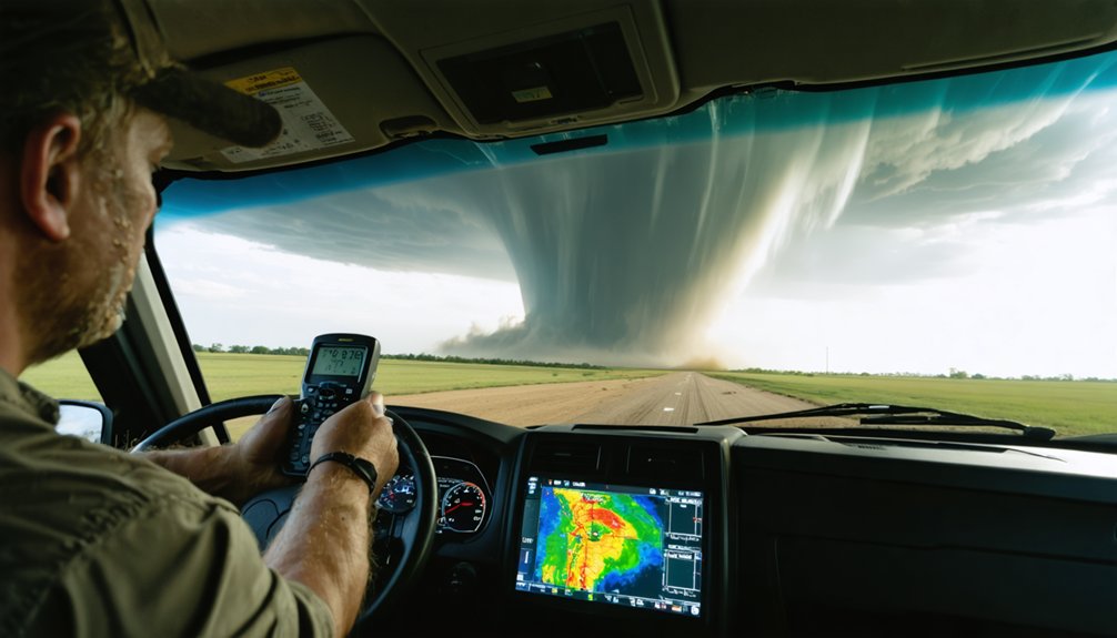
You deploy instrument arrays, radiosondes, and mobile Doppler radar units into environments where stationary infrastructure simply doesn’t exist, capturing pressure gradients, wind shear profiles, and thermodynamic data at critical proximity to convective cores.
That ground-level data tightens the feedback loop between observational meteorology and forecast model verification, advancing your understanding of tornado genesis and severe-storm lifecycle in ways that remote sensing alone can’t achieve.
Advancing Atmospheric Science
Storm chasing isn’t just about adrenaline—it’s a critical data-collection discipline that fills measurable gaps in atmospheric research. When you deploy sensor pods, weather balloons, or mobile radar arrays near active convection, you’re capturing real-time storm behavior that predictive modeling alone can’t replicate.
Research collaboration between field chasers and university teams has accelerated meteorological advancements, refining forecasting techniques and sharpening understanding of climate patterns.
Here’s what ground-level observational techniques deliver that remote systems can’t:
- Direct storm evolution data: You document atmospheric phenomena as they develop, validating or correcting existing analysis methods.
- Environmental conditions mapping: You measure precise temperature, moisture, and shear gradients tied to specific severe weather events.
- Technology integration: Drone-collected metrics and mobile instruments improve predictive modeling accuracy for future storm impacts.
This work drives real forecasting progress.
Deploying Instruments In Storms
Deploying instruments in active storm environments transforms chasing from observation into measurement. You’re not just watching—you’re collecting structured field data that drives real research applications.
Instrument types range from mobile radars and sensor pods to weather balloons and drone-mounted arrays, each designed for specific storm conditions. Deployment strategies determine placement timing, positioning angles, and retrieval windows, directly affecting data accuracy.
Collection methods must account for rapid atmospheric shifts, debris fields, and communication interference. Technology integration allows real-time data transmission to research teams monitoring remotely.
Field challenges demand strict safety protocols—you balance observational techniques against exposure risk constantly. Every successful deployment contributes measurable atmospheric readings that ground-truth computer models, refine severe-weather databases, and push the boundaries of what science can extract from extreme conditions.
What It Actually Takes to Chase Storms Safely
Chasing storms safely demands far more than courage or curiosity—it requires a working knowledge of mesoscale meteorology, real-time radar interpretation, and disciplined decision-making under rapidly changing conditions.
You’ll need structured training programs, layered risk assessment protocols, and sharp situational awareness before you’re within range of a supercell.
- Equipment essentials include mobile radar access, GPS tracking, dashcam systems, and redundant communication networks for real-time coordination.
- Escape routes must be pre-mapped using county road grids, accounting for storm motion vectors and potential debris fields.
- Emergency preparedness means carrying weather monitoring apps, first-aid kits, and maintaining contact with verified spotter networks.
Decision-making strategies break down fast when adrenaline overrides data.
Safety protocols exist precisely because freedom in the field depends on structured, repeatable discipline—not improvisation.
The Dangers Storm Chasers Face on Every Chase
Every chase carries a layered threat profile that extends well beyond the visible funnel. Weather unpredictability means conditions can deteriorate faster than your escape routes allow. Effective risk assessment demands you continuously recalibrate storm position, motion vector, and your vehicle’s exit geometry.
Storm safety isn’t passive—it requires active situational awareness every few minutes. Equipment reliability directly affects your decision-making window; a failed GPS or locked radar feed can compress your response time dangerously.
Chase preparation must include emergency procedures rehearsed before you’re in the field, not during. Mental resilience matters equally. Adrenaline degrades judgment, so you’ll need disciplined protocols that override impulse.
Injury prevention depends on maintaining operational margins others routinely abandon. Treat every intercept as a structured problem demanding precise, freedom-preserving decisions under pressure.
Storm Chasing as a Real Career Path
Storm chasing has evolved into a legitimate career with multiple income streams, but you’ll need to treat it like a business rather than a hobby.
Professional opportunities span documentary work, photography licensing, scientific employment, and media influence. Economic factors demand diversification — relying on a single revenue source leaves you financially exposed.
Storm chasing careers demand diversification — documentary work, licensing, and science contracts protect you when a single revenue stream dries up.
Key career realities you must understand:
- Safety training isn’t optional; it’s your professional foundation and liability shield.
- Research contributions through instrument deployment and ground-truth reporting strengthen your credibility and open university or government contracts.
- Community impact and public awareness campaigns can generate sponsorships and media partnerships.
Career challenges include inconsistent storm seasons and high operational costs.
However, personal fulfillment and the freedom to operate independently make storm chasing uniquely rewarding for those who build it strategically.
How Storm Chasers Make Weather Warnings More Accurate
When a tornado touches down, the difference between a 15-minute warning and a 3-minute warning can determine whether a community evacuates or takes a direct hit.
Storm reports from trained chasers dramatically improve data accuracy by providing ground-truth observations that radar alone can’t confirm. You’re filling critical gaps in forecasting challenges that automated systems consistently miss.
Technology integration—drones, mobile Doppler, sensor pods—amplifies what you transmit to warning centers in real time. That community impact is measurable: longer lead times, fewer casualties, smarter evacuations.
Public awareness improves when verified reports replace radar speculation. Safety protocols and ethical considerations govern how close you get, ensuring your data serves the public without compromising your position.
Your field observations aren’t supplemental—they’re structurally essential to modern warning accuracy.
Why Storm Chasing Still Grips the Public
Beyond the measurable warning improvements that chasers deliver, there’s a parallel force that keeps storm chasing embedded in public consciousness—one that operates on something closer to instinct than data.
Storm culture thrives because it merges adrenaline rush with genuine scientific purpose, creating a feedback loop that media influence amplifies across global audiences.
Public fascination intensifies when you watch real-time footage of wall clouds rotating overhead. Community engagement grows as educational outreach connects curious observers to professional methodology.
Real-time storm footage pulls curious minds closer, bridging raw spectacle with the disciplined science behind every chase.
Thrill dynamics pull you toward the edge—but safety protocols define how far that edge extends.
- Raw visual power of severe storm structure triggers visceral responses
- Documentary storytelling converts dangerous field work into accessible narratives
- Open-source chaser data democratizes atmospheric science for independent learners
Frequently Asked Questions
How Do Storm Chasers Fund Long Multi-Week Chasing Expeditions Across Multiple States?
You’ll fund multi-week, multi-state expeditions through sponsorship opportunities from weather equipment brands, crowdfunding platforms like Patreon, media licensing deals, documentary contracts, and scientific research grants that offset fuel, gear, and operational costs.
What Personal Background Do Most Successful Storm Chasers Typically Come From?
Hit the ground running with meteorological education — you’ll find most successful storm chasers combine formal atmospheric science training with sharp risk management instincts, self-taught radar analysis skills, and hands-on fieldwork experience built progressively over multiple independent chasing seasons.
How Has Storm Chasing Technology Changed Over the Past Two Decades?
You’ve watched storm tracking transform dramatically. You now deploy drones, portable Doppler radar, and GPS-linked sensor pods. Your data analysis capabilities have exploded, letting you process real-time atmospheric readings that’d have been impossible just twenty years ago.
Do Storm Chasers Coordinate With Each Other or Operate Completely Independently?
Imagine you’re chasing a supercell in Oklahoma — you’d rely on team dynamics and communication methods like radio networks and shared radar apps to coordinate, though you can also operate independently based on your own judgment.
What Mental Health Challenges Do Storm Chasers Face After Witnessing Destruction?
When you witness mass destruction, you’ll confront PTSD, anxiety, and grief. Building emotional resilience requires structured debriefing and peer support networks. Prioritizing trauma recovery through professional counseling keeps you operationally effective and mentally prepared for future high-risk deployments.
References
- https://en.wikipedia.org/wiki/Storm_chasing
- https://science.howstuffworks.com/nature/climate-weather/storms/storm-chaser.htm
- https://www.preventionweb.net/news/what-do-storm-chasers-really-do-two-tornado-scientists-take-us-inside-chase-and-tools-studying
- https://science.howstuffworks.com/nature/climate-weather/storms/storm-chaser5.htm
- https://www.pbs.org/newshour/science/inside-the-dangerous-and-unpredictable-science-of-storm-chasing
- https://environment.leeds.ac.uk/icas-research-impact/doc/storm-chasers-making-life-saving-forecasts
- https://www.reddit.com/r/stormchasing/comments/lvub71/how_important_are_storm_chasers_in_giving_data_or/
- https://makezine.com/article/science/storm-chasers-real-twister-tech/
- https://www.reddit.com/r/stormchasing/comments/1bv5pzs/what_drives_yall_to_storm_chase/
- https://www.youtube.com/watch?v=bKamLcO2YdE