Waterspouts fascinate you because they compress an entire meteorological sequence into a visible, real-time event. You can watch distinct phases unfold—dark spot, spiral pattern, spray ring, and mature vortex—in under ten minutes. The interaction between warm water and cool air creates structured, dramatic visuals that make atmospheric mechanics tangible. Fair weather types are relatively safe to observe, while tornadic variants signal serious danger. Understanding both types transforms what you’re seeing from spectacle into something you can actually interpret.
Key Takeaways
- Waterspouts form through visually dramatic phases—dark spot, spiral pattern, spray ring, and mature vortex—making the process captivating to observe in real time.
- The interaction between warm water and cool air creates a self-reinforcing, structured spectacle that visually demonstrates atmospheric mechanics unfolding naturally.
- Two distinct types exist, fair weather and tornadic, offering beginners diverse and contrasting phenomena to learn about and observe safely.
- Early warning signs like dark circular spots and rotating airflow teach beginners to recognize and anticipate natural weather events independently.
- Waterspouts form in accessible locations like the Great Lakes and tropical waters, making firsthand observation realistic for curious beginners.
What Makes Waterspouts Look So Dramatic?
Waterspouts earn their dramatic reputation through a combination of visible physical stages that unfold in real time.
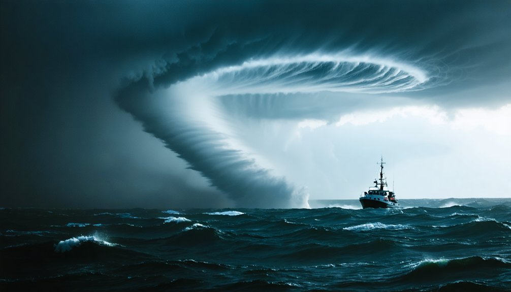
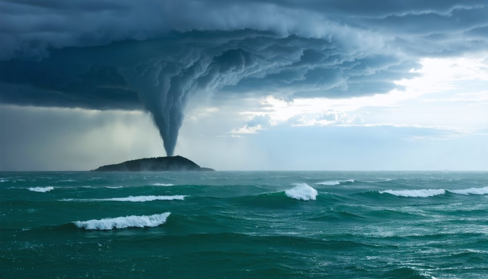
You’ll observe four distinct phases: a dark spot on the water’s surface, a developing spiral pattern, a turbulent spray ring, and finally a mature vortex with a hollow funnel connecting sky to sea.
These dramatic visuals emerge as spinning air and water mist form a funnel-shaped column averaging 50 meters in diameter.
Spinning air and water mist merge into a funnel-shaped column, averaging 50 meters wide at its peak.
The mesmerizing patterns develop because warm surface water heats rising air while cooler air rushes inward, generating visible rotation beneath cumulus clouds.
The spray vortex climbs several hundred feet, producing a visible wake and wave train below.
You’re fundamentally watching atmospheric mechanics perform in real time — structured, sequential, and visually striking.
The Two Types of Waterspouts Explained
Although they share a similar appearance, the two types of waterspouts — fair weather and tornadic — differ fundamentally in origin, intensity, and behavior.
Fair Weather waterspouts develop upward from warm water surfaces under building cumulus clouds, requiring no thunderstorm activity. They’re typically small, brief, and generate winds up to 80 km/h — weak enough that you can often observe them safely from a distance.
Tornadic waterspouts, however, carry full Tornadic Characteristics, originating as land tornadoes that migrate over water or forming directly within severe thunderstorms. They develop downward from storm clouds, producing destructive winds, hail, and lightning.
You should never underestimate them. Recognizing which type you’re observing isn’t just intellectually satisfying — it’s essential knowledge that directly informs how you respond when one appears.
How Does a Waterspout Actually Form?
When you observe a fair-weather waterspout forming, you’re witnessing a precise atmospheric sequence: warm water heats the air directly above it, causing that air to rise and creating a low-pressure zone at the surface.
Cooler surrounding air rushes inward to fill that void, and if winds at different altitudes are traveling at varying speeds or directions, that inflowing air begins to rotate.
This differential wind shear is the critical mechanical ingredient that transforms a simple updraft into a spinning vortex beneath developing cumulus clouds.
Warm Air Rises
The formation of a waterspout begins with a straightforward thermodynamic process: warm water heats the air directly above it, causing that air to rise rapidly.
As warm air ascends, it creates a low-pressure zone at the surface. Cooler, denser air rushes horizontally inward to fill that void. This inward rush doesn’t move in straight lines — it curves, initiating rotational movement.
The rising currents carry moisture upward, where it condenses under developing cumulus clouds. You’re fundamentally watching a self-reinforcing engine: warmer water generates stronger rising currents, which intensify surface inflow, which amplifies rotation.
Understanding this mechanism gives you predictive awareness — when you observe warm surface temperatures combined with active cumulus development overhead, the essential thermodynamic conditions for waterspout formation are already assembling themselves.
Wind Creates Spin
Rising air alone doesn’t create a waterspout — you need wind shear to supply the spin. Wind shear occurs when winds at different altitudes blow at varying speeds or directions, generating horizontal rotation in the atmosphere.
As warm air rises from the water surface, it intersects these rotating air masses and tilts them vertically. That vertical rotation intensifies as converging winds tighten the column, accelerating spin dynamics through conservation of angular momentum — identical to how a spinning skater speeds up by pulling their arms inward.
Simultaneously, air pressure drops sharply inside the developing vortex. This pressure differential pulls surrounding air inward and upward, strengthening the column further.
You’re fundamentally watching atmospheric mechanics self-organize into a structured, rotating system driven by temperature, moisture, and directional wind forces working simultaneously.
Waterspouts vs. Tornadoes: What’s Really Different?
Most people assume waterspouts are simply tornadoes over water, but three key distinctions separate them structurally, behaviorally, and regarding destructive potential. Understanding these waterspout characteristics clarifies the tornado similarities you’ve likely noticed.
First, structurally, water inside a waterspout originates from cloud condensation, not surface uplift.
Second, behaviorally, fair-weather waterspouts develop upward from the surface while tornadoes descend from storm systems.
Third, destructively, fair-weather types reach only 80 km/h winds, matching merely the weakest tornadoes.
You’ll also notice lifespan differences: waterspouts average 5-10 minutes versus considerably longer tornado durations.
Tornadic waterspouts, however, genuinely match land tornado destructive capacity since they originate as actual tornadoes moving over water.
Recognizing these distinctions lets you accurately assess risk rather than applying blanket assumptions to both phenomena.
Are Waterspouts Actually Dangerous?
Understanding how waterspouts compare to tornadoes naturally raises a practical question: should you actually be worried when you spot one? The answer depends entirely on type.
Fair weather waterspouts rarely threaten you directly—they’re brief, weak, and typically dissipate before reaching shore.
Tornadic waterspouts, however, carry genuine destructive force, matching land tornadoes in wind speed and hazard.
Your key danger indicators include darkening skies, associated thunderstorms, hail, and rapid funnel expansion. These signal tornadic activity requiring immediate action.
Practical safety measures are straightforward: move perpendicular to the waterspout’s path, never attempt to navigate through one, and monitor marine weather alerts consistently.
Authorities issue tornado warnings when waterspouts approach coastlines. Treat any waterspout near your vessel as a serious navigational threat until you’ve confirmed otherwise.
Where Are Waterspouts Most Common?
Waterspouts cluster where warm water and atmospheric instability intersect most reliably. Understanding Formation Zones helps you anticipate where these phenomena concentrate:
- Great Lakes peak activity runs August–October, when cold air masses override warm lake surfaces, generating powerful temperature differentials.
- Tropical Waters sustain year-round development wherever cumulus clouds build rapidly over heated ocean surfaces.
- Seasonal Patterns shift activity predictably—summer warmth expands viable zones, winter contracts them except during cold-air outbreaks.
- Rivers and inland lakes also qualify when humidity and surface temperature align correctly.
You’ll notice waterspouts aren’t random. They follow measurable atmospheric logic. Track surface water temperatures, monitor cumulus development, and you’ll identify high-probability zones before conditions fully materialize.
Knowledge converts spectacle into something you can actually predict and navigate deliberately.
Waterspout Warning Signs You Can Watch For in Real Time
Knowing where waterspouts form gives you a strategic advantage, but real-time observation sharpens that advantage into actionable awareness. Monitor the water surface first — a dark, circular spot signals rotating airflow beginning to organize.
Next, you’ll notice a spiral band pattern expanding outward, followed by a visible spray ring lifting from the surface. These sequential warning signals give you time to act before the mature vortex establishes itself.
Your most reliable visual cues are cumulus cloud development overhead paired with surface agitation below. When both align simultaneously, formation is imminent.
Fair weather waterspouts move slowly, giving you precious response time. Tornadic variants, however, advance rapidly from active storm cells. Recognize the progression, track cloud behavior, and you’ll consistently identify threats before they reach dangerous maturity.
Frequently Asked Questions
How Long Does a Typical Waterspout Last Before It Disappears?
You’ll typically watch a waterspout persist for 5-10 minutes before dissipating conditions break its structure. Duration factors like wind shear, humidity loss, and cooling water surfaces accelerate decay, ending the vortex’s brief, enchanting existence.
Can Waterspouts Pick up and Transport Fish or Other Animals?
Yes, an aquatic vortex can lift and transport fish and small animals. When you’re near one, you’ll witness animal transport through powerful rotating winds that carry aquatic life considerable distances before depositing them inland.
What Rare Winter Weather Phenomenon Resembles a Waterspout in Cold Conditions?
You’ll find snowspouts are rare winter vortexes resembling cold tornadoes, forming when frigid air meets warm lake water. The 1994 Lake Ontario event perfectly demonstrated steam rising, creating these fascinating, visually striking cold-weather phenomena.
At What Speed Do Waterspouts Typically Move Across the Water?
You’ll find waterspout dynamics carry these formations across water at 10-15 knots typically. Understanding wind speed patterns lets you predict movement, giving you the freedom to navigate safely and avoid these rotating columns effectively.
Have Any Unusual or Historically Notable Waterspout Events Ever Been Documented?
Yes, you’ll find historical events and notable sightings documented worldwide. The 1994 Lake Ontario snowspout stands out, where cold air over warm water produced rare steam-driven vortices, defying typical warm-weather formation patterns you’d normally expect.
References
- https://www.workybooks.com/resources/climate-science/waterspout
- https://www.weather.gov/apx/waterspout
- https://oceanservice.noaa.gov/facts/waterspout.html
- https://education.nationalgeographic.org/resource/waterspout/
- https://www.youtube.com/watch?v=lFnaJ6f9W0s
- https://www.youtube.com/watch?v=EvWeavNN0wE
- https://www.youtube.com/watch?v=TSLRSFpgIbI
- https://www.wlox.com/video/2019/07/21/what-are-waterspouts-how-do-they-form/
- https://www.wzzm13.com/article/weather/weather-impact-alert-how-waterspouts-form-west-michigan/69-9d7b2804-d1c8-4950-8522-a56999fd3b54
- https://www.reddit.com/r/explainlikeimfive/comments/1hm0dd/eli5_why_are_waterspouts_so_common_in_comparison/


