Storm intercept vehicles give you direct access to ground-level atmospheric data that radar systems can’t capture, filling critical measurement gaps where tornadogenesis actually occurs. You’re collecting real-time thermodynamic gradients, pressure perturbations, and boundary-layer wind profiles that Doppler radar scans from altitudes too high to resolve. Onboard sensors log temperature, humidity, and electric field data simultaneously, transmitting telemetry directly to forecasters. Each intercept mission strengthens warning accuracy in ways that deserve a much closer look.
Key Takeaways
- Storm intercept vehicles collect ground-level atmospheric data that Doppler radar cannot capture, filling critical gaps in severe weather monitoring.
- Onboard sensors measure temperature, pressure, humidity, and wind vectors, transforming vehicles into mobile atmospheric laboratories during storm events.
- Reinforced frames, aerodynamic designs, and steel anchoring systems allow SIVs to operate safely within EF3-strength tornado conditions.
- Real-time telemetry transmits directly to National Weather Service forecasters, enabling faster, more accurate tornado warnings and reducing false alarms.
- SIV data supports localized community alerts, improves emergency response coordination, and drives iterative improvements in severe weather forecasting models.
What Is a Storm Intercept Vehicle?
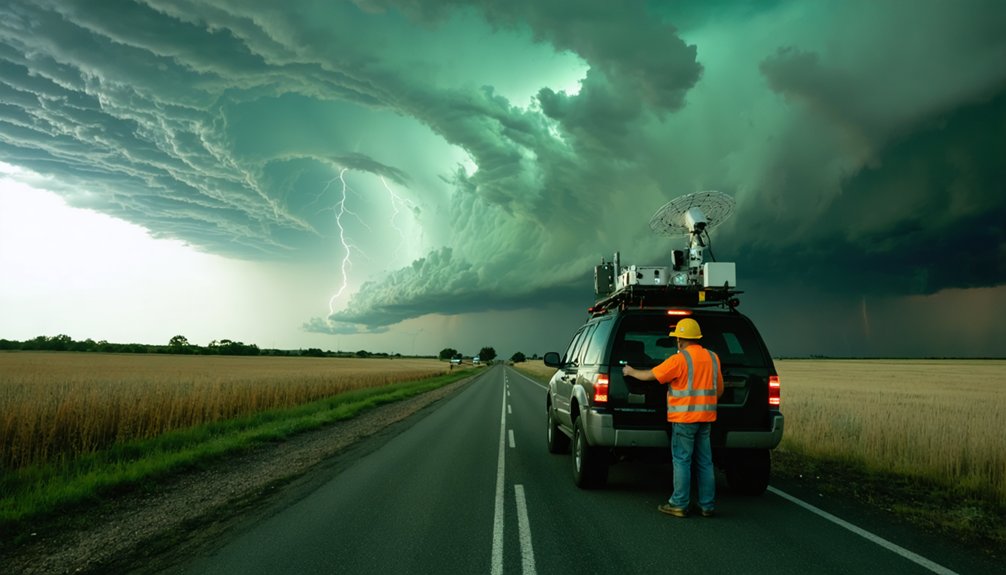
A storm intercept vehicle (SIV) is a purpose-built or heavily modified ground platform that carries meteorological instruments, cameras, and communication systems directly into or near severe thunderstorms and tornadoes to collect in situ data that remote sensing systems can’t capture at ground level.
You’ll find these platforms equipped with pressure sensors, thermodynamic probes, wind profilers, and real-time data transmission systems that feed directly into severe weather research models.
Storm intercept vehicles range from reinforced pickup trucks carrying basic sensor arrays to heavily armored units like the Tornado Intercept Vehicle, which weighs over 16,000 pounds and deploys ground spikes for stability.
From basic sensor-equipped pickup trucks to 16,000-pound armored behemoths with deployable ground spikes, SIVs exist across a dramatic spectrum.
Each platform gives researchers direct access to boundary-layer atmospheric data that Doppler radar simply can’t resolve, making SIVs indispensable tools for understanding severe weather dynamics at ground level.
Why Ground-Level Data Matters in Severe Thunderstorms
Ground-level data fills a critical gap that Doppler radar can’t close: radar scans the atmosphere from hundreds of meters above the surface, leaving the boundary layer—where tornadogenesis actually occurs—largely unresolved.
Storm intercept vehicles deliver ground level insights that directly capture atmospheric dynamics at the surface, where pressure gradients, moisture flux, and wind shear drive storm behavior.
In situ sensors mounted on intercept vehicles measure:
- Thermodynamic gradients revealing buoyancy and instability near the surface
- Pressure perturbations tied to mesocyclone intensification and tornado formation
- Boundary layer wind profiles that radar simply can’t resolve at fine scales
- Humidity fluctuations indicating inflow moisture feeding convective updrafts
These measurements feed directly into tornadogenesis models, sharpening forecast precision and strengthening warning systems you depend on when severe weather threatens.
What Sensors Do Storm Intercept Vehicles Carry?
Storm intercept vehicles pack a dense array of sensors that transform a reinforced truck into a rolling atmospheric laboratory.
You’ll find thermodynamic sensors logging temperature, pressure, and humidity alongside anemometers capturing real-time wind vectors critical to understanding storm dynamics.
Electric field meters quantify charge distributions, while rain gauges and hail sensors sharpen sensor accuracy during active precipitation events.
Data integration systems consolidate these inputs onto onboard computers, transmitting telemetry directly to research facilities for atmospheric profiling.
Data integration systems unify sensor inputs, streaming live telemetry to research facilities for precise, real-time atmospheric profiling.
Vehicle stability systems, including hydraulic ground spikes, anchor the platform so sensor readings aren’t compromised by chassis movement in high-wind environments.
This mechanical steadiness directly boosts operational efficiency, letting you extract clean, reliable datasets.
Together, these sensor types deliver the granular, ground-level measurements that remote systems simply can’t replicate.
How Are These Vehicles Built to Survive a Tornado?
Surviving a direct tornado encounter demands extreme engineering across every structural layer of an intercept vehicle. Tornado resilience isn’t accidental—it’s the result of calculated design choices that prioritize storm stability, sensor durability, and data integration under catastrophic conditions.
Key structural and functional features include:
- Vehicle armor: Reinforced frames with bullet-resistant windows up to 1.5 inches thick resist debris impacts at extreme velocities.
- Aerodynamic design: Hydraulic skirts reduce lift forces, keeping you grounded during violent wind loading.
- Ground anchoring: Steel spikes penetrate soil, preventing displacement in high-wind fields.
- Real time processing: Onboard computers continuously log and transmit atmospheric parameters despite mechanical stress.
These vehicles exceed 16,000 pounds, ensuring you maintain a stable platform where sensor durability and uninterrupted data integration remain operationally viable even inside EF3-strength tornadoes.
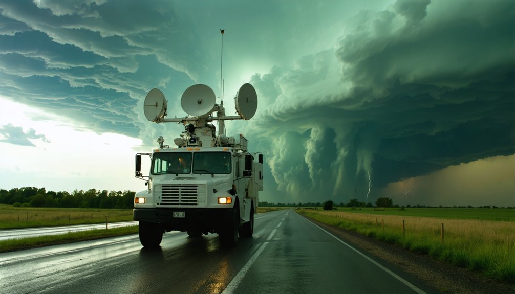
How Storm Intercept Vehicles Use Mobile Radar to Study Storm Interiors
While fixed ground-based radars struggle to resolve storm-interior structures at close range, mobile radar systems mounted on intercept vehicles—like Doppler on Wheels (DOW)—close that gap by positioning high-resolution scanning hardware directly adjacent to or within severe convective storms.
You get granular wind velocity data, reflectivity gradients, and rotational signatures that fixed networks simply can’t capture at comparable resolution.
DOW units scan storm interiors by positioning multiple vehicles simultaneously, enabling dual- or tri-Doppler analysis.
That triangulation lets researchers reconstruct three-dimensional wind fields inside supercells and mesocyclones with precision that single-radar geometries can’t achieve.
You’re effectively building a detailed kinematic map of the storm’s internal structure in real time, feeding that data directly into tornadogenesis models and improving both forecasting accuracy and severe weather warning lead times.
How Storm Intercept Vehicles Collect Real-Time Atmospheric Data
Beyond mobile radar, intercept vehicles carry five core sensor categories that capture real-time atmospheric data at ground level and within the storm boundary layer: temperature, pressure, humidity, wind, and electric field instruments.
These onboard systems log atmospheric measurements continuously, transmitting telemetry directly to research facilities as storm dynamics evolve.
You’re fundamentally deploying a mobile laboratory that records what fixed stations can’t reach. Key data streams include:
You’re deploying a mobile laboratory — capturing critical atmospheric data where no fixed station can follow.
- Thermodynamic sensors tracking temperature and moisture gradients near tornado inflow
- Barometric arrays detecting pressure drops tied to mesocyclone intensification
- Anemometers and wind profilers measuring directional shear within the boundary layer
- Electric field meters quantifying lightning potential and charge structure
This integrated suite lets researchers correlate ground-truth readings with simultaneous radar returns, building precise, high-resolution datasets that strengthen storm dynamics models and sharpen forecast accuracy.
Why Storm Intercept Vehicles and Radar Both Have a Role
Real-time sensor arrays on intercept vehicles give you ground-level measurements that radar fundamentally can’t produce—but that doesn’t make radar redundant.
Radar maps reflectivity and velocity across the entire storm volume, giving you broad structural context across multiple altitudes. Intercept vehicles then fill the critical gap radar leaves: near-surface thermodynamic and kinematic data that directly govern storm dynamics and tornadogenesis.
You need both systems working together. Radar identifies rotation signatures and mesocyclone development, directing intercept vehicles toward ideal positioning.
Those vehicles then capture in situ pressure drops, wind shear gradients, and moisture flux that clarify each stage of the tornado lifecycle. Neither platform alone produces a complete dataset.
Combined, they deliver the integrated observational record researchers require to build accurate convective storm models and sharpen warning systems.
How Storm Intercept Vehicle Data Improves Tornado Warnings
When you examine how storm intercept vehicles improve tornado warnings, you’ll find that real-time telemetry transmission is central to the process—onboard computers log pressure drops, wind shifts, and moisture anomalies and push that data directly to research facilities and operational forecasters.
You can trace measurable gains in warning accuracy to this ground-level stream of in situ measurements, which fills critical gaps that Doppler radar alone can’t resolve, particularly in the boundary layer where tornadogenesis initiates.
Storm spotters and intercept teams also perform ground-truth verification of radar-detected signatures, confirming rotation, debris, and funnel contact with the surface before warnings are issued or upgraded.
Real-Time Data Transmission
As storm intercept vehicles close in on a supercell, onboard computers log pressure drops, wind shifts, and moisture surges in real time, transmitting that telemetry directly to National Weather Service forecasters and emergency managers.
This live data transmission compresses storm analysis timelines, giving you faster, more accurate warnings before conditions deteriorate.
Key parameters streamed during intercept operations include:
- Surface pressure gradients indicating mesocyclone intensification
- Dew point surges signaling inflow moisture feeding tornado development
- Wind vector shifts marking rear-flank downdraft boundaries
- Reflectivity correlations cross-referenced against mobile Doppler radar returns
Each data stream feeds operational forecast models independently of fixed radar infrastructure.
You get ground-truth verification that satellite and remote sensing alone can’t deliver, directly strengthening warning lead times and reducing false alarm rates across affected communities.
Enhancing Tornado Warning Accuracy
Ground-truth observations from storm intercept vehicles directly sharpen tornado warning accuracy by filling critical gaps that Doppler radar can’t resolve at low altitudes.
When you integrate in situ pressure, wind, and thermodynamic data collected near the surface, you’re capturing tornado dynamics that remote sensing simply misses. Intercept vehicles confirm rotation signatures, measure actual wind speeds, and document storm evolution in real time—giving forecasters verified data rather than radar interpretations alone.
That ground-level intelligence feeds directly into warning decisions. Spotters relaying precise, sensor-backed observations reduce false alarm rates and extend lead times, giving communities more actionable response windows.
You’re not relying on probabilistic radar signatures; you’re working with measured atmospheric parameters that strengthen the meteorological basis for every warning issued during a severe weather event.
Ground-Truth Storm Verification
Storm intercept vehicles close the verification gap that Doppler radar leaves open by delivering measured atmospheric parameters directly from within or adjacent to the storm’s boundary layer.
When you correlate in situ data with radar-derived storm signatures, you’re producing ground verification that tightens forecast confidence and reduces false alarm rates. This process transforms raw radar interpretation into actionable, validated intelligence.
Key ground verification outputs include:
- Pressure drops and thermodynamic gradients confirming supercell intensification
- Wind speed measurements validating rotational storm signatures at surface level
- Moisture and humidity readings cross-referenced against mesocyclone depth estimates
- Real-time telemetry feeding directly into operational warning decision frameworks
Each data point you collect narrows the uncertainty margin forecasters face, enabling earlier, more precise tornado warnings without waiting on radar alone to resolve critical storm-scale features.
How Footage From Intercept Vehicles Advances Tornado Research
Footage captured by tornado intercept vehicles provides researchers with visual data that no remote sensing platform can fully replicate. When you analyze high-resolution IMAX recordings from vehicles like TIV 1 and TIV 2, you’re accessing frame-by-frame documentation of tornado dynamics—rotation rates, debris lofting behavior, and boundary layer structure—that Doppler radar simply can’t resolve at ground level.
Through photogrammetric visual analysis, you can calculate wind velocities by tracking debris trajectories across sequential frames, producing quantitative kinematic data. These measurements validate and refine numerical models of tornadogenesis.
Intercept footage also reveals structural features—suction vortices, corner flow regions, and wall cloud behavior—that remain invisible to fixed radar networks. You gain irreplaceable observational ground truth, directly strengthening forecasting models and ultimately improving public warning accuracy.
How Storm Intercept Vehicle Data Is Improving Future Forecasts
When you examine how storm intercept vehicles transmit data, you’ll find that onboard computers log atmospheric parameters—pressure, temperature, humidity, and wind speed—and relay that telemetry in real time to research facilities and operational forecast centers.
This live data stream lets meteorologists cross-reference ground-truth measurements against Doppler radar signatures, tightening the accuracy of severe storm warnings before conditions deteriorate.
You can trace direct improvements in warning lead time to these real-time transmissions, as intercept-derived observations fill critical data gaps that fixed sensor networks and remote sensing alone can’t resolve.
Real-Time Data Transmission
As intercept vehicles close in on severe thunderstorms and tornadoes, they’re transmitting live telemetry—pressure gradients, wind vectors, temperature, and humidity—directly to research facilities and operational forecast centers.
Real time analytics process this raw data stream instantly, enabling meteorologists to refine warning parameters before conditions deteriorate further.
Key transmission capabilities include:
- Live sensor feeds updating wind and pressure readings continuously during storm penetration
- Data visualization dashboards converting raw telemetry into interpretable storm structure maps
- Mobile radar integration syncing vehicle-based Doppler returns with fixed-network radar composites
- Emergency relay protocols pushing critical storm metrics to NWS forecast offices in near-zero latency
You’re fundamentally gaining ground-truth verification that satellites and stationary radars can’t independently provide—closing observational gaps precisely where forecasting accuracy matters most.
Enhancing Severe Storm Warnings
Ground-truth data collected by storm intercept vehicles is directly sharpening the algorithms that drive severe storm warning systems. When you integrate in situ pressure, wind, and thermodynamic readings with Doppler radar signatures, you close the observational gap that remote sensing alone can’t bridge.
That data integration strengthens probabilistic models, tightening forecast lead times before storm impact reaches populated areas.
Storm intercept vehicles provide verified, high-resolution measurements that climatological databases previously lacked at ground level. You’re feeding operational forecasters corroborated data points that reduce false alarm rates and improve warning specificity.
Emergency managers then issue more targeted alerts, giving communities actionable intelligence rather than broad, region-wide watches.
Every intercept mission fundamentally stress-tests current warning frameworks against real atmospheric conditions, producing iterative model improvements that translate directly into stronger public safety outcomes.
Frequently Asked Questions
How Much Does It Cost to Build a Storm Intercept Vehicle?
You’re looking at a cost breakdown ranging from $250K–$1M+. Vehicle components like armor plating, reinforced frames, hydraulic skirts, bullet-resistant windows, sensor arrays, and onboard computing systems drive expenses considerably depending on your build’s complexity.
Who Funds Storm Intercept Vehicle Research and Operations?
Who’s bankrolling the chase? You’ll find storm funding flows from NSF research grants, NOAA, and private vehicle sponsorship. Universities and independent chasers also shoulder operational costs, driving scientific freedom through decentralized, data-driven severe weather exploration.
Can Storm Intercept Vehicles Operate Safely in Urban Environments?
You can deploy storm intercept vehicles in urban environments, but vehicle design must account for tighter maneuvering constraints. Urban safety demands you prioritize debris risk, traffic density, and infrastructure obstacles while leveraging armor and real-time telemetry data.
How Many Storm Intercept Vehicles Are Currently Active in the US?
“Knowledge is power” — you’ll find no single official count exists, but dozens of active storm tracking units operate across the U.S., blending cutting-edge vehicle technology from university programs, NSSL, and independent researchers pursuing severe weather data.
What Training Is Required to Operate a Storm Intercept Vehicle?
You’ll need meteorology fundamentals, vehicle operation proficiency, and storm safety protocols. Master Doppler radar interpretation, intercept positioning strategies, and emergency egress procedures. Real-world field experience alongside seasoned chasers sharpens your decision-making under rapidly evolving, high-risk severe thunderstorm conditions.
References
- https://journals.ametsoc.org/downloadpdf/view/journals/wefo/14/4/1520-0434_1999_014_0558_ahossi_2_0_co_2.pdf
- https://www.youtube.com/watch?v=x5ZHg6WKuwQ
- https://news.okstate.edu/articles/communications/2014/osu-students-design-storm-penetrating-search-and-rescue-uavs.html
- https://journals.ametsoc.org/view/journals/bams/61/6/1520-0477-61_6_560.xml
- https://www.youtube.com/watch?v=yhF2bsyGsi8
- https://www.youtube.com/watch?v=Uu9qsqedojg
- https://stormchasers.fandom.com/wiki/Tornado_Intercept_Vehicle
- https://science.howstuffworks.com/nature/climate-weather/meteorological-instruments/tiv.htm
- https://en.wikipedia.org/wiki/Tornado_Intercept_Vehicle
- https://www.popularmechanics.com/science/environment/a44950472/chasing-tornadoes-tornado-alley/


