Doppler radar advancements have completely transformed how you chase and analyze severe storms. You can now detect tornadic rotation signatures miles above the surface before touchdown occurs, giving you critical lead time. Mobile platforms like Doppler on Wheels (DOW) deliver high-resolution, close-range storm dynamics, while dual-Doppler systems eliminate blind spots by reconstructing three-dimensional wind fields. The evolution from WSR-3 to WSR-88D technology pushed warning times considerably further. There’s far more to uncover about these powerful tools.
Key Takeaways
- WSR-88D systems significantly improved tornado detection by identifying dangerous rotation signatures, increasing warning lead times through precursor rotation monitoring.
- Mobile Doppler on Wheels (DOW) units enable close-range storm measurements, capturing real-time tornado lifecycle data during active chase events.
- Dual-Doppler radar eliminates blind spots by reconstructing three-dimensional wind fields, improving tornado forecasting precision through enhanced multi-angle data collection.
- Near-real-time data transmission allows storm chasers to rapidly adapt to shifting conditions, improving situational awareness and independent decision-making in the field.
- Advanced rotational signature detection across multiple altitudes enables storm chasers to identify tornadic activity miles before surface contact occurs.
How Doppler Radar Works for Storm Chasers
Doppler radar operates on a deceptively simple principle: it transmits short pulses of radio waves and measures the phase shift in signals reflected back from precipitation like raindrops and snowflakes. That phase shift—the Doppler shift—tells you whether targets are moving toward or away from the antenna.
For storm chasers, this radar technology translates raw frequency data into actionable intelligence. You’re not guessing at storm dynamics; you’re calculating precise wind speed and direction within developing systems.
The WSR-88D network identifies dangerous signatures including rotation, wind shear, and debris patterns, often detecting tornadic rotation miles above ground before touchdown occurs.
The WSR-88D network catches tornadic rotation high above ground, long before a funnel ever threatens the surface.
This early detection window gives you the freedom to position strategically, maximizing data collection while maintaining critical safety margins during active tornado pursuit operations.
What Does Doppler Radar Reveal Inside a Developing Tornado?
Once you understand how Doppler radar detects rotation and wind shear from the outside, the next question becomes what that data actually reveals about a tornado’s internal structure.
WSR-88D systems decode radar signatures that expose critical tornado dynamics before touchdown occurs.
Here’s what the velocity data actually shows you:
- Rotation depth and intensity across multiple altitudes simultaneously
- Wind shear gradients indicating rapid acceleration zones within the vortex
- Debris signatures confirming ground contact through distinct radar return patterns
- Tornadic Vortex Signatures revealing tight rotational couplets tied to destructive potential
You’re basically reading a tornado’s internal blueprint in real time.
That independent access to raw storm structure data means you’re not waiting on filtered information—you’re analyzing the storm yourself.
How Doppler Radar Detects Tornado Rotation Before Touchdown
Before a tornado ever touches ground, WSR-88D systems are already reading the rotational signatures developing miles above the surface.
You’re watching tornado genesis unfold through velocity data before any visible funnel descends. The radar’s rotation analysis tracks wind shear patterns at multiple altitudes simultaneously, identifying the Tornadic Vortex Signature that researchers first isolated in 1970s data.
Phase-shifted return signals reveal inbound and outbound winds tightening into recognizable rotation patterns.
You’re not waiting for confirmation at ground level—you’re acting on precursor data that gives you genuine lead time.
WSR-88D systems detect dangerous rotational signatures, debris patterns, and wind shear with 99 percent reliability, delivering near-real-time data streams.
That detection window translates directly into extended warning time, letting you make calculated decisions before conditions deteriorate.
Mobile Doppler Radar Trucks That Changed Storm Chasing
Fixed installations like WSR-88D give you wide-area coverage, but they can’t close the distance gap when you need high-resolution data directly inside a storm’s core.
That’s where Doppler on Wheels (DOW) systems changed everything for storm tracking and field data collection.
Mounted on flatbed trucks, DOW units let you position radar within striking distance of active tornadoes, capturing lifecycle data that fixed systems simply can’t reach.
Here’s what these mobile platforms deliver:
- Close-range velocity and rotation measurements during active tornado events
- Full storm tracking across tens of thousands of chase miles
- Hurricane and blizzard data collection alongside tornado research
- High-resolution storm dynamics through portable S-band dual-polarization technology
You’re getting direct, proximity-based measurements that transform raw storm data into actionable atmospheric research.
Why Dual-Doppler Radar Beats a Single System
When you position two WSR-88D systems approximately 40 miles apart, you capture storm data from multiple angles and altitudes simultaneously, eliminating the blind spots that cripple a single-radar setup.
That multi-angle coverage lets you reconstruct three-dimensional wind fields inside a tornadic storm, giving you far more accurate velocity and rotation data than one unit can provide.
You’re fundamentally doubling your detection capability, which translates directly into earlier identification of dangerous signatures and longer warning lead times for communities in a tornado’s path.
Multi-Angle Storm Coverage
A single Doppler radar station captures storm velocity data from only one angle, leaving significant blind spots in wind field analysis.
Dual-Doppler systems positioned roughly 40 miles apart eliminate these gaps by sampling storm dynamics from two independent perspectives simultaneously.
You gain a complete three-dimensional wind field reconstruction that no single unit delivers. This radar evolution reveals data previously inaccessible to forecasters and researchers alike.
Key advantages of multi-angle coverage include:
- Cross-beam analysis resolves horizontal wind vectors missed by single-station geometry
- Altitude layering captures velocity signatures at multiple storm levels simultaneously
- Reduced cone-of-silence errors through complementary beam angles
- Enhanced rotation detection identifies tornadic signatures earlier across the full storm column
Two radars working together don’t just double your data—they exponentially increase analytical precision.
Enhanced Tornado Detection
Single-station Doppler radar reveals storm velocity along one radial axis only, leaving cross-beam wind components unresolved and creating critical gaps in tornadic circulation analysis.
When you deploy dual-Doppler systems roughly 40 miles apart, you’re capturing three-dimensional wind fields from independent perspectives simultaneously, eliminating those blind spots entirely.
This geometric advantage transforms tornado forecasting precision dramatically. You’ll resolve horizontal divergence, vertical vorticity, and rotational shear that single-radar configurations simply can’t distinguish.
WSR-88D systems identify dangerous storm patterns including wind shear gradients and debris signatures across multiple altitudes, but dual configurations extract the full velocity vector field.
You’re detecting tornadic rotation miles above ground before touchdown occurs, extending warning lead times and giving people the freedom to make informed, potentially life-saving decisions before conditions deteriorate.
Improved Data Accuracy
The fundamental limitation of single-station Doppler radar lies in its radial constraint—you’re only measuring velocity components moving directly toward or away from the antenna, leaving cross-beam motion entirely invisible.
Dual-Doppler systems positioned ~40 miles apart eliminate this blind spot through triangulated data validation, reconstructing full three-dimensional wind vectors.
You gain critical accuracy improvements across multiple dimensions:
- Complete wind field mapping from two independent perspective angles
- Cross-beam velocity recovery that single stations can’t capture
- Redundant measurements confirming storm-relative motion simultaneously
- Altitude-stratified data revealing vertical wind structure throughout storm columns
VORTEX2 deployed nearly 30 sensor types leveraging these dual-perspective advantages.
When both radar platforms agree on rotation signatures, you’re working with verified, actionable intelligence rather than incomplete radial snapshots.
Real-Time Doppler Radar Tools Storm Chasers Use in the Field
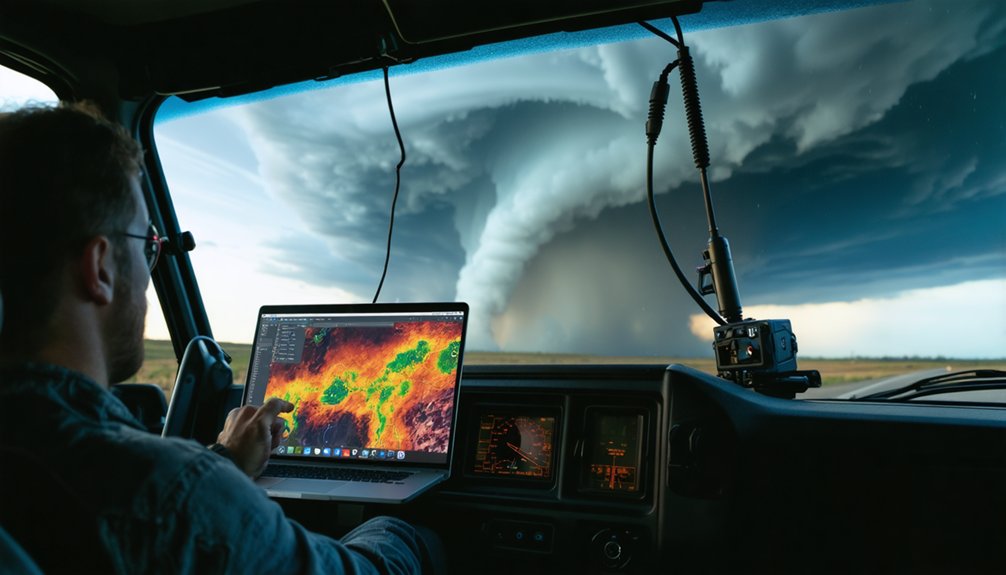
Storm chasers rely on several real-time Doppler radar tools to collect, analyze, and act on critical storm data in the field.
You’ll use mobile platforms like Doppler on Wheels (DOW), mounted on flatbed trucks, to position close to tornadic activity and capture high-resolution velocity data throughout a tornado’s full lifecycle.
Phased array technology, adapted from Navy surveillance systems, gives you complete storm visualization in under one minute, a critical advantage when conditions shift rapidly.
You’ll also deploy portable S-band dual-polarization systems for detailed precipitation analysis.
Advanced tracking capabilities let you monitor rotation signatures, wind shear, and debris patterns across multiple altitudes simultaneously.
These tools, combined with near-real-time data transmission, give you the operational precision needed to make independent, informed decisions during rapidly evolving severe weather events.
How WSR-88D Doppler Radar Transformed Tornado Warning Times
Advancing from the WSR-3 systems of earlier decades, WSR-88D Doppler radar fundamentally transformed how you detect and warn against tornado threats. This warning technology delivers measurable improvements in tornado forecasting accuracy through several critical capabilities:
- Identifies dangerous rotation signatures, wind shear, and debris patterns before touchdown
- Detects tornadic vortex signatures across multiple altitudes using velocity data analysis
- Distinguishes F4 and F5 tornado characteristics with precision earlier systems couldn’t achieve
- Extends warning lead times by detecting precursor rotation miles above ground
You’re no longer operating with minimal reaction time. WSR-88D processes real-time velocity data with 99 percent reliability, transmitting at National Weather Service speeds.
That technological edge means earlier warnings, sharper storm structure analysis, and more preparation time for communities directly in a tornado’s path.
Frequently Asked Questions
What Government Agency Funds Advanced Doppler Radar Research and Development Programs?
The NSF and NOAA — twin pillars of scientific sovereignty — fund federal funding initiatives that advance your radar technology, while the Department of Commerce’s gold medal recognition confirms their commitment to Doppler research and development.
How Many Researchers Participated in the VORTEX2 Multinational Tornado Research Effort?
You’ll find that over 150 researchers participated in VORTEX2’s multinational researcher collaboration, giving you unprecedented insight into tornado dynamics through coordinated sensor deployment across nearly 30 different radar and measurement systems from universities and government organizations.
What Award Did NSSL Receive for Contributions to the NEXRAD Program?
Like a beacon cutting through storm-darkened skies, you’ll find that NSSL recognition shone brightest when the Department of Commerce awarded its Gold Medal for the program’s Nexrad impact on advancing national weather forecasting capabilities.
When Were Dual-Doppler Airborne Measurement Concepts First Tested Successfully?
You’ll find that dual-Doppler airborne measurement concepts were first successfully tested in 1989, combining WSR-88D with airborne technology to push measurement accuracy boundaries — a breakthrough that’s now become routine in advanced tornado research operations.
How Reliable Are Super-Resolution Doppler Data Streams During Severe Weather Events?
Like a heartbeat you can count on, super-resolution Doppler data streams deliver 99% reliability, giving you near-real-time transmission that matches National Weather Service speed, ensuring data accuracy remains rock-solid even when tracking extreme storm intensity.
References
- https://www.youtube.com/watch?v=R_d0wbUQ_oM
- https://www.nsf.gov/impacts/doppler
- https://www.weather.gov/dtx/beecherradar
- https://www.nssl.noaa.gov/education/svrwx101/tornadoes/detection/
- https://nps.edu/-/nps-tornado-chasers-use-advanced-radar-to-improve-forecasting
- https://www.rainviewer.com/blog/how-to-use-rain-radar-for-storm-chasing.html
- https://www.stormtours.com/information/storm-chasing-technology/
- https://www.youtube.com/watch?v=3jylMpqA68g
- https://www.facebook.com/WeatherBrains/posts/now-ready-for-playback-weatherbrains-1054-i-want-my-own-radar-ive-earned-it-this/1528418375953758/
- https://www.facebook.com/mattnoyesweather/posts/dual-polarization-radar-has-been-an-incredible-advancement-in-storm-tracking-abl/845002663649003/


