Chasing supercell storms puts you inside the most mechanically complex and destructive atmospheric systems on Earth, where rotating updrafts exceed 150 mph and pressure drops of 100+ mb can precede tornado touchdown within minutes. You’ll collect real scientific data, sharpen your forecasting instincts across CAPE values, wind shear, and dewpoint thresholds, and witness storm structures no classroom can replicate. Each intercept builds skills that veteran chasers spend decades refining, and there’s far more to unpack about why this pursuit becomes a lifelong obsession.
Key Takeaways
- Supercell storms generate rotating updrafts exceeding 150 mph, offering chasers a rare, visually spectacular display of extreme atmospheric power.
- Chasing supercells contributes real-time data to NWS, filling critical gaps that radar alone cannot resolve and improving forecast accuracy.
- Witnessing tornado genesis firsthand reveals the dramatic transformation of horizontal vorticity into violent vertical rotation in real time.
- The unpredictability of each supercell, with unique SRH readings and tornado paths, ensures every chase delivers a distinct experience.
- Interaction with veteran chasers builds community bonds, strengthens safety protocols, and fosters continuous learning within the spotter network.
What Makes Supercell Storms the Most Powerful on Earth
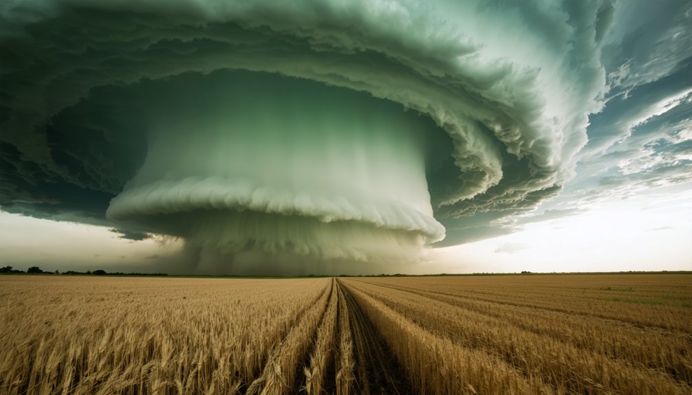
Supercell storms rank as Earth’s most destructive convective systems, generating rotating updrafts that can exceed 150 mph and sustain themselves for hours across hundreds of miles.
Their storm morphology distinguishes them from ordinary thunderstorms through a persistent mesocyclone driven by rotational mechanics unique to environments with extreme atmospheric instability.
Wind shear profiles—directional and speed-based—organize storm dynamics into structured supercell characteristics, separating precipitation patterns from the updraft zone. This displacement allows updraft strength to intensify without self-destructive interference from downdrafts.
Cloud formation reaches towering cumulonimbus heights, often exceeding 50,000 feet.
Hail characteristics within these systems reflect violent internal processes, producing stones exceeding 2 inches in diameter.
You’re witnessing nature’s most mechanically efficient storm engine when you’re out there chasing these systems.
Storm Chasing Puts You Feet From a Forming Tornado
When you position your vehicle within the forward-flank downdraft boundary, you’re placing yourself meters from the mesocyclone’s rotating wall cloud as it descends toward surface contact.
You’ll observe the condensation funnel‘s laminar flow change to turbulent rotation in real time, capturing pressure drops of 100+ mb and inflow winds exceeding 70 mph feeding the updraft core.
This proximity to tornado genesis delivers raw, unfiltered atmospheric data that no remote sensing platform can replicate.
Tornado Genesis Up Close
Few atmospheric events rival the raw mechanics of tornado genesis, and storm chasing puts you within visual range of every stage.
You’ll observe tornado dynamics as wind shear organizes horizontal vorticity into vertical rotation. Storm evolution unfolds fast — mesocyclone behavior shifts within minutes as low-level helicity spikes.
You’re tracking vortex structure as the rotating wall cloud descends, watching atmospheric conditions tighten the circulation.
Radar analysis confirms what your eyes detect: rotational velocity increasing, storm intensity climbing toward EF3-EF5 potential.
Precipitation effects shape visibility, separating classic supercells from HP variants where the mesocyclone disappears into rain.
Rotation patterns tighten as the funnel extends earthward.
You’re not watching a screen — you’re positioned precisely where atmospheric physics produces one of Earth’s most powerful concentrated forces.
Mesocyclone Proximity Rewards
Proximity to a mesocyclone delivers something radar can’t replicate — direct sensory confirmation of rotational velocity, pressure gradients, and structural changes happening in real time.
You’re reading the storm’s architecture firsthand, applying mesocyclone observation techniques that ground-truth what WSR-88D reflectivity and velocity data only approximate.
You’ll detect inflow acceleration, identify wall cloud lowering, and track RFD boundary positioning — inputs that sharpen your storm structure analysis with precision no remote sensor matches.
Pressure drops become tactile. Rotation becomes visible, measurable, and immediate.
You’re not interpreting second-hand data; you’re collecting it at the source, feeding verification loops that improve ensemble model outputs and spotter network accuracy.
That positioning — deliberate, calculated, informed — puts real observational power directly in your hands.
Supercell Chasing Delivers Real Scientific Value
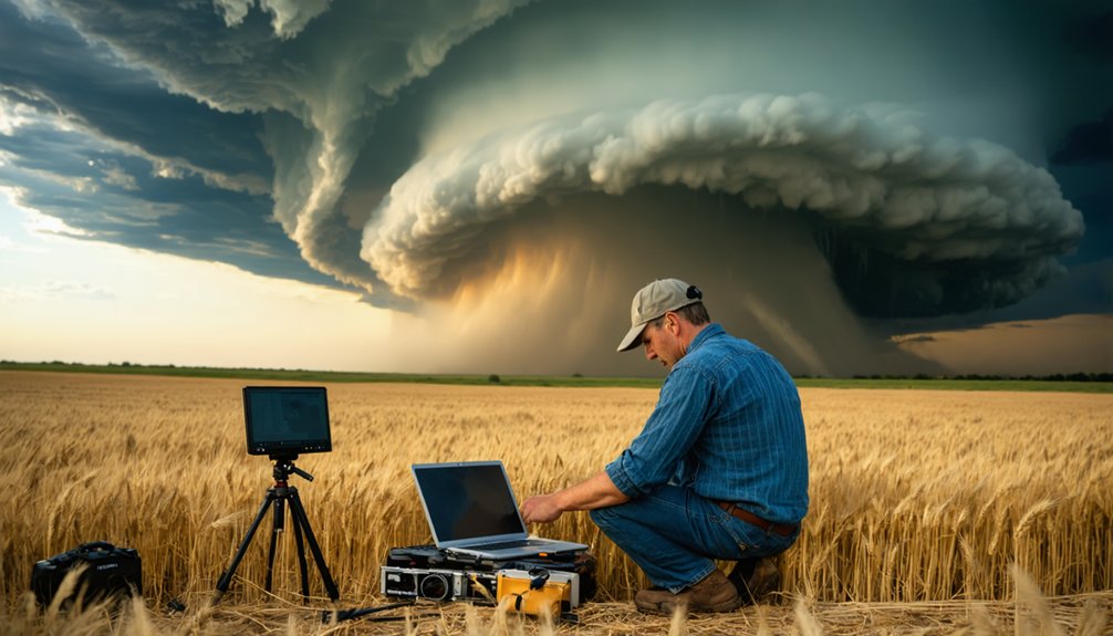
When you chase supercells, you’re collecting real-time atmospheric data that ground-based instruments and satellites simply can’t replicate at close range.
Your mobile observations—pressure gradients, wind shear measurements, and inflow angles—feed directly into numerical weather prediction models, sharpening their accuracy.
You’re not just witnessing severe weather; you’re actively validating or challenging the forecast methods that meteorologists depend on to protect lives.
Real-Time Data Collection
Storm chasers collect real-time data that ground-based radar and satellite systems can’t fully replicate.
You’re positioned directly within the storm’s environment, capturing atmospheric variables that transform data accuracy and refine predictive modeling.
Technology advancements like mobile mesonets, Doppler on Wheels, and GPS radiosondes let you document storm patterns with precision no remote system matches.
Three critical data points you’ll collect:
- Surface pressure gradients — measuring inflow boundaries that visualization tools can’t detect remotely
- Thermodynamic profiles — recording temperature, humidity, and dewpoint shifts that validate environmental impact assessments
- Wind shear measurements — quantifying rotational velocity supporting stronger safety measures and public warnings
Your commitment to chase ethics and communication strategies guarantees this raw data reaches researchers, strengthening community engagement and advancing forecast science meaningfully.
Forecast Method Validation
Chasing supercells lets you validate forecast models against real atmospheric conditions with precision no simulation replicates. When you’re positioned beneath a rotating wall cloud, you’re comparing predicted hodograph data against observed storm behavior in real time.
That direct comparison exposes gaps in forecast accuracy that desk-based analysis simply can’t detect.
You’ll document whether convective parameters—CAPE values, wind shear profiles, lifted index readings—actually produced what models anticipated. When they don’t align, you’ve identified a forecasting weakness worth investigating.
Storm behavior in the field frequently defies model output, and your observations become correction data that sharpens future predictions.
Your chase logs, radar screenshots, and atmospheric measurements feed directly into verification databases that researchers use to refine numerical weather prediction algorithms.
You’re not just witnessing science—you’re actively advancing it.
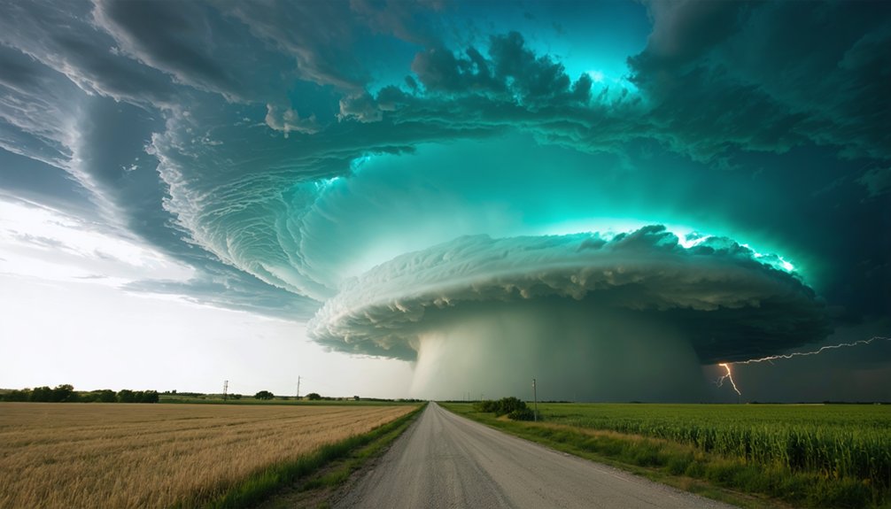
Supercell Storms Produce Photography You Cannot Replicate
Few natural phenomena rival the supercell’s photographic potential.
You’re capturing extreme weather architecture that no studio can manufacture. The rotating mesocyclone, mammatus cloud formations, and lightning-illuminated precipitation cores deliver storm photography opportunities unavailable anywhere else.
Three visual elements define supercell documentation:
- Wall cloud descent — You’ll photograph a rotating lowering dropping 500-1,000 feet beneath the rain-free base, clearly separated from surrounding precipitation.
- Inflow banding — Layered striated bands feeding directly into the updraft create geometric precision that reveals atmospheric mechanics visually.
- Rear-flank downdraft clear slot — Wrapping around the mesocyclone, this cloud-free arc exposes the rotating core with dramatic contrast against surrounding storm structure.
You control your position, your angle, your timing.
No two supercells produce identical structure. That freedom defines the pursuit.
Supercell Chasing Teaches Forecasting No Classroom Can
Beyond the camera’s viewfinder, every supercell you chase becomes a live forecasting laboratory. You’re reading atmospheric conditions in real time, cross-referencing storm dynamics against your morning’s sounding data, and validating forecasting techniques no textbook simulation can replicate.
You watch storm evolution unfold across minutes, not slides — tracking mesocyclone tightening, observing cloud behavior shift as low-level helicity increases, and recognizing supercell characteristics that distinguish classic structures from HP variants.
You’ll decode weather patterns by connecting radar signatures to what’s physically developing ahead of you. Storm visualization becomes instinctive. You internalize tornado behavior by witnessing wall cloud rotation, RFD surges, and precipitation core displacement firsthand.
These weather phenomena rewire your forecasting instincts permanently. Each intercept sharpens your analytical edge in ways no classroom assignment ever could.
How Supercell Chasers Feed Real-Time Data to Warning Networks
When you chase supercells, you transmit real-time position, storm structure, and rotation data directly to the National Weather Service through integrated spotter networks like SKYWARN.
Your ground-level observations fill critical gaps that radar alone can’t resolve, giving forecasters precise, actionable intelligence on mesocyclone development and hail size.
This direct pipeline between your field data and warning systems measurably compresses lead times, strengthening public alerts before tornadoes touch down.
Real-Time Data Transmission
Modern supercell chasers don’t just observe storms—they’re active nodes in a real-time data transmission network that directly feeds National Weather Service warning operations.
Your telemetry systems, weather sensors, and visual documentation tools push storm tracking data into operational pipelines within seconds, improving data accuracy across warning zones.
Here’s what your real-time analytics transmit:
- Mesocyclone position and rotation rate — GPS-tagged storm monitoring coordinates synced to NWS data integration platforms
- Surface weather sensor readings — pressure drops, wind shifts, and temperature gradients captured during cloud observation sequences
- Video and photo documentation — timestamped visual feeds confirming rotation, wall clouds, and funnel development
Your data transmission capability transforms chase operations from personal adventure into precision instruments that compress warning lead times and protect lives.
Spotter Network Integration
Every supercell chaser operating within a structured spotter network functions as a distributed sensor node, feeding ground-truth observations directly into NWS warning pipelines.
Through spotter collaboration, you’re transmitting verified storm tracking data—rotation estimates, hail size, damage indicators—that radar alone can’t confirm.
Network reliability depends on your disciplined adherence to safety protocols, ensuring continuous data exchange without compromising your position.
Technology integration via platforms like Spotter Network and GR2Analyst lets you push timestamped GPS-tagged reports instantly.
Community engagement through outreach programs and training opportunities sharpens your observational precision and standardizes information sharing across the network.
You become an autonomous field asset operating within a coordinated infrastructure—free to chase your chosen intercept point while simultaneously strengthening the collective warning architecture that protects millions downstream from your position.
Warning System Enhancement
Real-time data from supercell chasers directly shortens the lead time between storm identification and public warning issuance. Your ground-level observations strengthen data accuracy within warning systems, enabling meteorologists to refine risk assessment models faster than radar alone permits.
When you’re actively feeding information into emergency protocols, you’re enhancing response strategies across entire regions. Technology integration connects your mobile instruments directly to NWS networks, sharpening storm pattern recognition and triggering precise safety measures.
Here’s how you contribute:
- Ground-truth reports validate radar-indicated mesocyclone signatures, reducing false alarm rates.
- Real-time hail size and wind speed data sharpen public education messaging during active events.
- Community outreach coordination links your field observations to local emergency managers, accelerating warning dissemination and strengthening infrastructure-wide response capabilities.
How Chasers Read Shear, Instability, and Moisture to Pick the Right Storm
Before you ever get in the car, you need to assess three atmospheric ingredients that determine whether a storm will become a supercell: wind shear, instability, and moisture.
Your shear analysis should confirm directional and speed shear, targeting 0-6km bulk shear exceeding 40 knots.
Instability assessment means checking CAPE values above 2,500 J/kg, while moisture evaluation requires dewpoints at 60°F or higher.
You’ll pull predictive models like the SPC mesoanalysis and NAM soundings for accurate data interpretation.
Chaser techniques demand you cross-reference multiple weather patterns rather than relying on single-model output.
Atmospheric conditions shift fast, so real-time storm selection depends on your ability to synthesize radar, surface observations, and skew-T data simultaneously.
Read the atmosphere correctly, and you’ll intercept the right storm.
Hail the Size of Baseballs and 100 Mph Winds Show What Supercells Can Do
Once you’ve identified a supercell candidate using shear, CAPE, and moisture data, you’ll quickly realize the storm’s destructive output matches its atmospheric inputs. Hail dynamics and wind patterns define what supercells deliver at ground level.
- Hailstone diameter reaches 5.1 cm (2 inches) when updraft velocities sustain ice cycling through the storm’s precipitation core — critical data for storm impact assessment and equipment tips like protective vehicle positioning.
- Outflow winds exceeding 100 mph create straight-line damage indistinguishable from weak tornadoes, demanding strict storm safety protocols within the chase community.
- Photography techniques require rapid repositioning as atmospheric conditions shift — downbursts reduce visibility and compress safe operating distances.
Weather forecasting accuracy improves when chasers document these outputs directly, reinforcing chase ethics through disciplined, data-focused observation rather than reckless proximity.
Classic, LP, and HP Supercells Each Behave Differently
Although supercells share a common rotating updraft structure, their precipitation distribution produces three distinct chase profiles you’ll need to recognize before positioning.
Classic supercells offer an unobstructed rain-free base, clear mesocyclone visibility, and manageable storm interaction distances. You’ll read supercell characteristics most efficiently here.
Low-precipitation (LP) supercells present a sculpted, nearly transparent updraft column with minimal hail threat but extreme visibility advantages.
High-precipitation (HP) supercells wrap rain and hail around the mesocyclone, obscuring rotation and markedly increasing your risk during storm interaction. HP environments demand GPS-assisted positioning and conservative escape routes.
Each variant requires adjusted intercept geometry, different safe zones, and recalibrated proximity thresholds. Misidentifying your storm type compromises both data collection quality and your personal safety margin considerably.
Why Supercell Storm Chasing Becomes a Lifelong Pursuit
Obsession takes root the moment you successfully forecast a supercell’s track, position your vehicle within two miles of a rain-free base, and watch a wall cloud descend beneath a rotating mesocyclone exactly where your hodograph analysis predicted.
That adrenaline adventure compounds through experience sharing, photographic artistry, and community engagement with veteran chasers who’ve logged thousands of intercept miles.
- Unpredictability thrill — No two supercells produce identical SRH readings, mesocyclone depths, or tornado paths, sustaining your passion pursuit indefinitely.
- Educational impact — Your documented intercepts contribute real-time datasets that sharpen forecast validation models.
- Mentorship opportunities — Storm storytelling transfers critical positioning knowledge to newer chasers, strengthening the entire spotter network’s nature connection and safety protocols.
The open road never loses its pull.
Frequently Asked Questions
What Insurance Coverage Do Storm Chasers Typically Carry for Their Vehicles?
⚡ Your shield against nature’s fury: you’ll need extensive coverage for vehicle damage, plus storm chaser liability insurance—typically $1M+ policies—protecting your freedom to pursue the storm while keeping your financial exposure precisely managed.
How Much Does a Typical Storm Chasing Expedition Cost per Day?
You’ll typically spend $150–$300 daily on storm chasing expenses, covering fuel, lodging, food, and equipment. Effective budget planning guarantees you’re allocating roughly $50–$100 for gas alone, depending on your chase distance and target area.
What Legal Permits Are Required to Chase Storms Across State Lines?
With 10,000+ annual chasers nationwide, you’ll find no specific storm chasing regulations or interstate travel permits required. You’re free to cross state lines using standard driver’s licensing, vehicle registration, and applicable traffic laws.
Are There Age Restrictions for Participating in Organized Storm Chasing Tours?
Most organized storm chasing tours require participants to be 18+, though minors can join with parental consent. You’ll find tour safety protocols and storm chasing ethics guidelines vary by operator, so verify age policies directly before booking.
What Mental Health Impacts Do Veteran Storm Chasers Commonly Experience?
You’ll likely develop heightened anxiety management challenges after repeated exposure to violent storms. Veteran chasers commonly report PTSD symptoms requiring trauma coping strategies, with studies indicating 34% experience persistent hypervigilance and stress-related psychological impacts from extreme weather encounters.
References
- https://stormtrack.org/threads/best-way-to-approach-a-storm-supercell.12165/
- https://www.stormchasing.com/quickstart.pdf
- https://en.wikipedia.org/wiki/Supercell
- https://www.weather.gov/spotterguide/supercell1
- https://www.youtube.com/watch?v=nPsSuWo5S48
- https://www.madscitech.org/scg/intro.html
- https://www.youtube.com/watch?v=0QL0aVmZGi4
- https://www.reddit.com/r/stormchasing/comments/1k58tj2/why_do_you_storm_chase/
- https://crimereads.com/natures-deadliest-thunderstorms-and-the-people-who-chase-them/
- https://www.youtube.com/watch?v=JNKAcDeBJbg


