Efficient storm chasing coordination starts with studying SPC outlooks and road networks before storms fire. You’ll need constant communication across all chase vehicles using radios, apps, and cell phones. Split duties clearly — one driver, one radar operator, one spotter — so nobody’s overwhelmed. Prioritize visual storm observation over screen data, and pre-map perpendicular escape routes with shelter fallbacks loaded into GPS. The tips below break each critical layer down further.
Key Takeaways
- Pre-chase planning should include reviewing SPC outlooks, road networks, escape routes, and cell coverage maps before reaching the target area.
- Assign dedicated roles—driver, radar operator, and spotter—before departure to ensure operational clarity and controlled storm intercepts.
- Deploy layered communication tools including radios, cell phones, and real-time apps while establishing emergency protocols and check-in intervals.
- Prioritize visual storm observation over radar data to detect immediate threats like rotation, debris, and cloud base changes in real time.
- Map perpendicular escape corridors, pre-load shelter locations into GPS, and build contingency routes to maintain mobility during emergencies.
Plan Your Storm Chase Target Zone Before Storms Fire
Before a single storm fires, your success as a storm chaser hinges on methodical pre-chase planning. Start by monitoring SPC convective outlooks days ahead to assess storm potential across your target area. Cross-reference mesoscale analysis, surface observations, and NWS discussions to sharpen your forecast confidence.
Don’t neglect infrastructure. Study road networks, bridges, and escape routes before you arrive. Freedom of movement depends on knowing your options before conditions deteriorate.
Verify cell coverage using FCC maps to guarantee real-time communication stays intact when it matters most.
Attend an NWS Spotter Safety Class to reinforce your safety protocols and tactical decision-making. Preparation isn’t optional — it’s the foundation that separates effective chasers from reckless ones.
Plan early, plan precisely, and you’ll position yourself for a successful intercept.
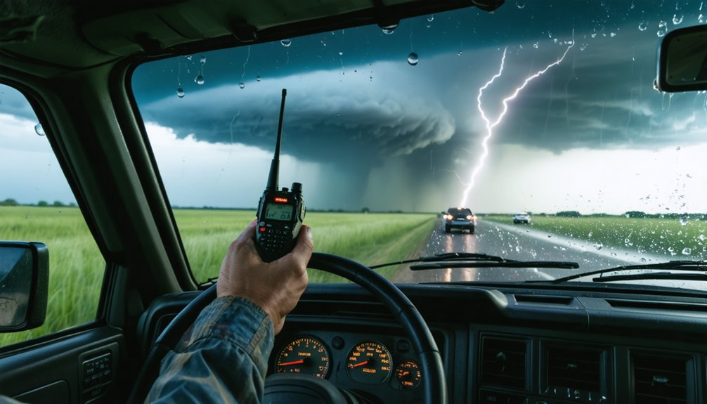
Keep Every Chase Vehicle in Constant Contact
Once your target zone is locked and your team is mobile, maintaining constant contact across every chase vehicle becomes your operational backbone. You can’t afford gaps in coordination when storm dynamics shift rapidly.
Deploy layered communication tools — radios, cell phones, and real-time apps like Spotter Network — simultaneously to eliminate blind spots between vehicles.
Redundant communication layers — radios, apps, and cell coverage — close the gaps that cost storm chasers their operational edge.
Divide responsibilities deliberately: one person drives while another monitors radar and relays position updates. You’ll prevent task saturation and keep situational awareness sharp across the entire convoy.
Establish emergency protocols before departure, not during chaos. Define rally points, escape corridors, and check-in intervals in advance.
If contact breaks, every driver should already know the contingency plan. Your team’s mobility advantage disappears the moment communication collapses, so treat coordination as non-negotiable infrastructure.
Split Chase Duties Between Driver, Radar, and Spotter
Splitting duties cleanly across your team is what separates controlled intercepts from dangerous improvisation. When you split responsibilities deliberately, each member owns a critical function. Your driver focuses entirely on road conditions, traffic, and positioning.
Your radar operator tracks storm structure, RFD gust fronts, and inflow signatures without distraction. Your spotter maintains continuous visual observation, calling out debris, rotation, and lightning proximity.
This division isn’t just efficient — it’s essential. Task saturation kills situational awareness faster than any storm. When one person drives, reads radar, and watches the sky simultaneously, critical details get missed.
You enhance teamwork by establishing these roles before the chase begins, not during it. Brief your crew, confirm assignments, and enforce them. Operational clarity under pressure keeps your team mobile, informed, and alive.
Read the Storm, Not Just the Screen
Radar gives you data, but the storm gives you truth. You can’t afford to fixate on your screen while the atmosphere is performing in real time ahead of you. Visual observation is irreplaceable — it reveals rotation, wall clouds, RFD gust fronts, and debris clouds faster than any app refresh cycle.
Train yourself to read storm behavior directly: watch how the updraft towers, how the inflow strengthens, how cloud bases lower and tighten. These are your immediate threat indicators. Radar lags. Your eyes don’t.
Balance both inputs deliberately. Assign radar monitoring to a dedicated team member so you can maintain eyes on the storm. That division of attention keeps your situational awareness sharp and your positioning decisions grounded in what’s actually unfolding around you.
Pre-Plan Perpendicular Exits and Shelter Fallbacks
Before you ever reach your target area, you need to map your escape corridors. Study road networks, identify perpendicular exit routes away from storm motion, and mark solid shelter locations before conditions deteriorate.
- Prioritize paved, perpendicular exit routes over parallel roads that trap you alongside a tornado’s track.
- Pre-load shelter locations like hospitals, overpasses, and sturdy structures into your GPS.
- Cross-reference FCC coverage maps so you’re never blind in critical moments.
- Avoid dirt roads entirely on high-precipitation days—mud kills your mobility fast.
- Build contingency routes so every primary exit has a backup.
Your freedom to maneuver depends entirely on decisions you make before the storm ever forms. Plan aggressively. Adapt instantly.
Frequently Asked Questions
How Do You Manage Chaser Convergence Traffic on High-Risk Days?
On high-risk days, you’ll want to slow down and practice solid chaser etiquette to manage traffic management challenges. Coordinate positions via radio, avoid clustering near targets, and maintain clear escape routes for your team’s freedom and safety.
Which Cell Phone Carriers Provide the Best Coverage in Tornado Alley?
Like a lifeline in a storm’s fury, you’ll want to run coverage comparisons before chasing. Verizon and AT&T dominate carrier reliability across Tornado Alley’s rural corridors, but always verify using FCC maps for your specific target area.
What Radar Apps Work Best for Real-Time Storm Data Integration?
For real-time storm data integration, you’ll want GRLevelX, RadarScope, or RadarOmega. These radar app features pull from multiple storm data sources, giving you Doppler overlays, RFD tracking, and seamless situational awareness to chase freely and safely.
How Do You Track the RFD Gust Front During an Active Chase?
Like a predator circling prey, you’ll track RFD dynamics by monitoring your radar’s inflow tail and gust front detection signatures. Watch storm cell behavior shifts, maintain chase communication, and reposition aggressively before the RFD wraps completely around.
When Should Storm Chasers Call 911 Versus Other Reporting Channels?
Call 911 only as your last resort under emergency protocols. You should prioritize reporting guidelines using Spotter Network, Twitter, or RadarScope for communication strategies. Reserve 911 strictly for life-threatening situations where standard safety measures and reporting channels aren’t available.
References
- https://www.weathercentertx.com/weather-101-different-types-of-weather/storm-chasing-101/
- https://www.wiu.edu/SevereWeather/images/presentations/How_to_Effectively_Storm_Chase.pdf
- https://stormtrack.org/threads/basic-storm-chasing-process.29691/
- https://www.youtube.com/watch?v=nxPSFg2R8YY
- https://www.livingskytours.com/storm-chasing-101/
- https://www.gabegarfield.com/blog/zerotohero
- https://www.stormchasingusa.com/blog/learning-the-basics-about-storm-chasing/