A wall cloud is a localized lowering of a thunderstorm’s cloud base, marking the strongest updraft within a supercell’s mesocyclone. It forms when warm, moist inflow converges with cool downdraft air, dropping the lifting condensation level. Up to 90% of tornadoes originate from wall clouds, and roughly 25% of wall clouds produce tornadoes. When you spot persistent rotation exceeding 10 minutes with strong southeast inflow, tornado probability rises sharply. There’s much more to understand about this critical atmospheric process.
Key Takeaways
- A wall cloud is a localized lowering of a thunderstorm’s cloud base, marking the strongest updraft and indicating significant tornado potential.
- Wind shear creates horizontal rotation that tilts vertically, forming a mesocyclone that drives wall cloud development beneath supercell thunderstorms.
- The convergence of warm inflow and cool downdraft air lowers the lifting condensation level, producing organized wall cloud structures.
- Tornadogenesis occurs when a rotating funnel cloud extends downward and contacts the surface, driven by updraft strength and inflow moisture.
- Approximately 25% of wall clouds produce tornadoes, with rotation persisting over 10 minutes significantly increasing tornado probability.
What Is a Wall Cloud?
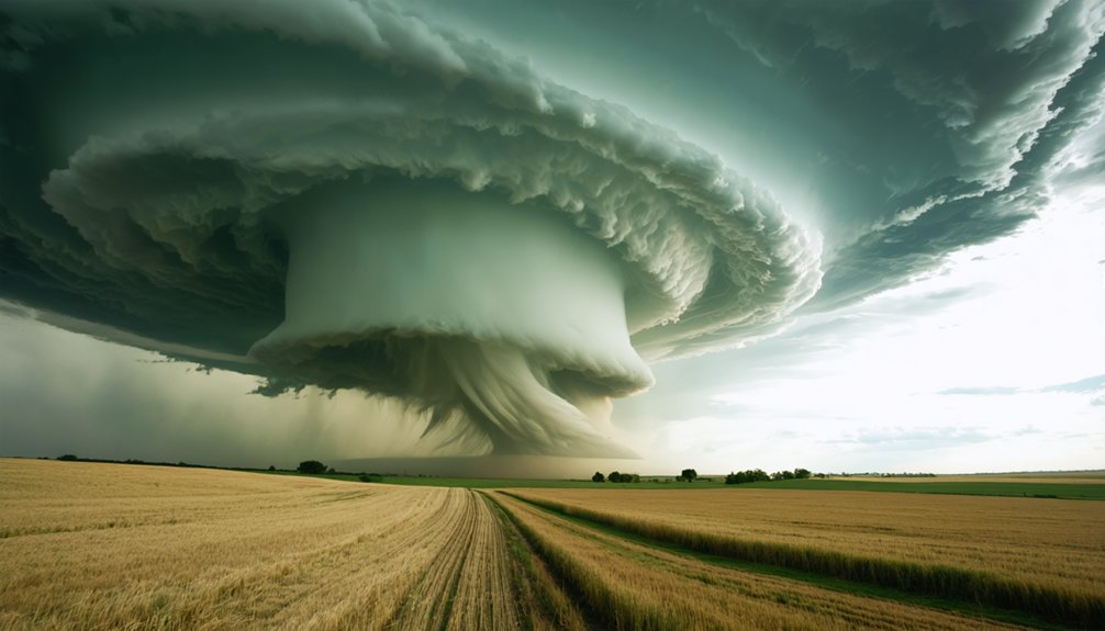
A wall cloud is a localized lowering of the cumulonimbus cloud base, forming directly beneath the rain-free base of a thunderstorm where the updraft is strongest.
You’re looking at a structure that signals the storm’s most intense vertical motion. Wall cloud characteristics include a visibly lowered base, persistent rotation, and rapid upward movement — all driven by rain-cooled, humid air getting pulled into a strengthening updraft.
As that air rises and saturates at a lower altitude, the cloud base drops measurably.
Wall cloud significance becomes clear when you understand that up to 90% of tornadoes originate from these structures.
Rotating wall clouds specifically indicate an active mesocyclone, making them critical identifiers for tornado potential.
Recognizing one early gives you a decisive advantage in evaluating severe storm threats.
Why Supercells Create the Conditions for Wall Clouds
When you examine a supercell thunderstorm, you’ll find that its rotating updraft—the mesocyclone—is the primary engine driving wall cloud formation.
The supercell’s updraft pulls warm, moist surface air upward at intense velocities, converging with evaporatively cooled air from the forward-flank downdraft region to create a saturated, low-pressure zone beneath the storm’s base.
This convergence drops the lifting condensation level considerably, producing the localized cloud lowering you recognize as a wall cloud.
Supercell Updraft Dynamics
Supercells generate wall clouds because their updrafts operate at an intensity that ordinary thunderstorms can’t match. You’re looking at updraft strength measured in tens of meters per second, creating sustained vertical acceleration that weaker storm cells simply can’t sustain. This force pulls massive volumes of boundary-layer air upward continuously, driving the moisture dynamics that define wall cloud formation.
As the updraft ingests rain-cooled air from the forward-flank downdraft region, it forces that air to saturate at lower altitudes than the primary cloud base. The lifting condensation level drops measurably, producing the characteristic lowered base you identify as a wall cloud.
Without a supercell’s rotational structure and persistent updraft engine, this convergence of warm inflow and evaporatively cooled air never achieves the organization necessary for wall cloud development.
Mesocyclone Formation Process
The mesocyclone’s formation begins with wind shear—specifically, the horizontal rotation generated when wind speed and direction change with altitude. A supercell’s powerful updraft tilts this horizontal rotation into the vertical plane, establishing mesocyclone behavior that defines the storm’s rotational core.
You’re fundamentally watching atmospheric angular momentum get redirected. As updraft patterns strengthen, they stretch the rotating column vertically, intensifying the spin through vortex tube stretching. This process concentrates low-level rotation beneath the storm’s base.
The rotating column then dynamically lowers the Lifted Condensation Level, pulling moist, rain-cooled air back into the updraft.
Convergence between warm inflow and cool downdraft air completes the mechanism. This convergence creates the physical conditions necessary for wall cloud development directly beneath the mesocyclone’s base.
How a Wall Cloud Forms Beneath a Thunderstorm
Beneath a cumulonimbus cloud, a wall cloud forms through a precise sequence of atmospheric interactions driven by the storm’s updraft. Rain-cooled air from the forward-flank downdraft gets pulled back into the strengthening updraft, saturating rapidly at a lower altitude. This drops the Lifted Condensation Level (LCL), producing the characteristic lowered base defining wall cloud characteristics.
Key atmospheric conditions triggering formation include:
- Evaporative cooling reducing air temperature while raising dew point
- Convergence of warm inflow air and cool downdraft air
- Updraft strength overpowering descending rain-cooled air masses
- Rapid saturation compressing the dew point depression considerably
You’re watching the storm’s engine expose itself. The lowered base marks the updraft’s core — the precise zone where tornado potential concentrates and mesocyclone dynamics intensify.
How the Mesocyclone Shapes and Lowers the Wall Cloud
When a mesocyclone strengthens within a supercell, it actively pulls the rotating cloud base downward, lowering the wall cloud in a tightly focused column beneath the storm’s rain-free base.
You’ll observe this process as cool, evaporatively-chilled air from the forward-flank downdraft converges with the warm, moist inflow, forcing saturation at progressively lower altitudes and tightening the mesocyclone’s base.
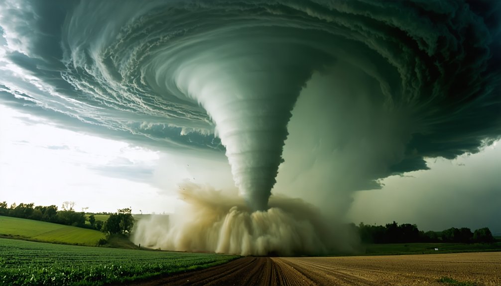
As the mesocyclone continues lowering, adiabatic cooling causes water vapor to condense into a visible funnel cloud that descends toward the surface—classifying as a tornado the moment it makes ground contact.
Mesocyclone’s Rotational Lowering Effect
As a supercell’s mesocyclone intensifies, it exerts a powerful downward pull on the storm’s rotating air mass, physically shaping and lowering the wall cloud toward the surface.
The rotational dynamics tighten the mesocyclone’s core, forcing the cloud base downward through convergent pressure gradients.
Key mechanisms driving this lowering effect include:
- Pressure drop: Rapid rotation creates a localized low-pressure zone beneath the mesocyclone
- Inflow acceleration: Surface-based warm air gets pulled inward, saturating at progressively lower altitudes
- LCL reduction: High moisture content drops the lifting condensation level considerably
- Funnel initiation: Continued lowering shifts the cloud base into a visible condensation funnel
You’re witnessing atmospheric physics operating at maximum efficiency—each rotation tightening the system’s grip toward the ground.
Cool Air Convergence Dynamics
The mesocyclone’s convergence zone acts as the storm’s architectural force, pulling cool, rain-evaporated air from the forward-flank downdraft region back into the rotating updraft. This cool air dynamics process saturates incoming air parcels at lower altitudes, physically dropping the Lifted Condensation Level below the primary storm base.
You’re watching air mass convergence operate in real time when the wall cloud descends. Evaporatively cooled air, already moisture-laden from precipitation, re-enters the updraft and reaches saturation faster than the surrounding environment. This compressed saturation threshold forces visible condensation to occur hundreds of feet lower than the storm’s main base.
The stronger your inflow winds from the southeast and east, the more aggressively this convergence tightens, accelerating wall cloud descent and intensifying mesocyclone organization—critical preconditions for tornadogenesis.
Funnel Cloud Descent Process
Once the mesocyclone’s base tightens and low-level pressure drops sufficiently, condensation begins extending downward from the wall cloud floor, initiating the visible funnel cloud descent.
You’re watching adiabatic cooling convert water vapor into visible droplets as the mesocyclone pulls surface air upward.
Key funnel cloud characteristics and lifecycle stages include:
- Condensation funnel forms as the LCL drops below the primary cloud base
- Rotational acceleration intensifies as the funnel narrows and stretches downward
- Surface pressure deficit draws the funnel toward ground contact
- Tornadogenesis threshold occurs when the condensation funnel touches the surface
The funnel cloud lifecycle typically spans minutes, driven by updraft strength and inflow moisture.
Persistent rotation exceeding 10 minutes statistically elevates tornado probability greatly, making continuous observation critical for accurate threat assessment.
Rotating vs. Non-Rotating Wall Clouds
While all wall clouds signal a significant updraft within a supercell, rotating and non-rotating wall clouds differ substantially in their tornado potential. When you observe rotating dynamics, you’re watching a mesocyclone actively tightening its circulation—a direct precursor to tornadogenesis.
Most intense tornadoes emerge exclusively from these rotating structures. Statistically, tornadic wall clouds exhibit rapid, violent rotational and vertical ascending motions, persisting for tens of minutes before a tornado develops.
Most intense tornadoes emerge exclusively from rotating wall clouds exhibiting rapid, violent motion persisting for tens of minutes.
Non-rotating characteristics, by contrast, indicate weaker surface-based inflow and less dramatic vertical motion. These wall clouds typically dissipate without producing tornadoes.
You can distinguish them by their slower, subdued movement and shorter persistence. Understanding this distinction gives you a critical analytical edge—rotation speed and persistence duration remain your two most reliable indicators of imminent tornado development.
What the Numbers Say: Wall Clouds and Tornado Probability
Statistics sharpen your understanding of wall clouds from visual curiosity to actionable forecast tool. Tornado statistics reveal measurable thresholds that separate dangerous wall cloud characteristics from benign ones.
Key data points you need to track:
- Up to 90% of tornadoes originate from wall clouds
- Only ~25% of wall clouds actually produce tornadoes
- Tornadic wall clouds persist for tens of minutes before touchdown
- Strong southeast/east inflow considerably elevates tornado probability
These numbers reframe your situational awareness. You’re not watching every wall cloud equally — you’re filtering for persistence, rotational velocity, and inflow intensity.
When a wall cloud sustains rotation beyond 10 minutes while drawing aggressive surface-based inflow, your probability threshold shifts dramatically upward. Data doesn’t guarantee outcomes, but it eliminates guesswork and sharpens your response timing decisively.
Visual Signs a Wall Cloud Is About to Produce a Tornado
Knowing what to look for transforms a wall cloud observation into a real-time probability assessment. When you’re storm spotting, watch for these critical indicators: a persistent, lowering cloud base lasting 10-plus minutes signals elevated tornado warning conditions.
Rapid upward motion—visible as air and debris being aggressively pulled skyward—indicates extreme atmospheric instability. Increasing rotational speed within the wall cloud reflects intensifying wind shear and mesocyclone tightening.
Strong inflow winds from the southeast, driven by elevated moisture levels, confirm a surface-based updraft is feeding the storm structure. Tail cloud formation extending outward from the main cloud base marks dangerous convergence zones.
When multiple indicators align simultaneously—persistent rotation, violent vertical motion, and strengthening inflow—your probability of witnessing tornadogenesis increases substantially. Recognize these signals, and you maintain situational awareness during severe weather.
How a Wall Cloud Becomes a Tornado
The transformation from wall cloud to tornado follows a precise atmospheric sequence driven by mesocyclone dynamics. As the mesocyclone intensifies, it pulls the wall cloud downward while surface inflow tightens the vortex.
Understanding this tornado lifecycle helps you recognize when storm structure becomes critically dangerous.
Key stages in the change:
- The mesocyclone base lowers as convergent inflow strengthens beneath the wall cloud
- Adiabatic cooling condenses water vapor into a visible rotating funnel
- Surface low pressure accelerates the funnel’s descent toward the ground
- Ground contact officially classifies the vortex as a tornado
Approximately 25% of wall clouds produce tornadoes under these conditions.
Persistent rotation exceeding tens of minutes, combined with rapid vertical motion, signals imminent tornadogenesis.
You’re watching the storm’s engine reach maximum output.
What Wall Cloud Behavior Tells You Before a Tornado Hits
Before a tornado strikes, wall cloud behavior delivers measurable, observable warnings you can’t afford to misread.
You’re watching storm prediction data unfold visually in real time.
Monitor these behavioral indicators:
Persistence — A wall cloud lasting 10+ minutes signals elevated tornado probability. Non-tornadic wall clouds dissipate faster.
Rotation speed — Rapid, violent rotation distinguishes tornadic wall clouds from benign ones. Slower motion reduces immediate risk.
Vertical motion — Aggressive upward movement within the cloud formation indicates a strengthening updraft pulling surface air inward.
Inflow winds — Strong southeast-to-east surface winds feeding the storm confirm mesocyclone intensification.
Cloud lowering — Incremental descent toward the ground precedes funnel development.
You’ve got minutes, not hours. Recognizing these behavioral cues gives you the actionable lead time to protect yourself.
Frequently Asked Questions
Can Wall Clouds Form Outside of Supercell Thunderstorms in Other Storm Types?
Yes, you’ll find wall clouds can form in non-supercell formation storm types, though they’re rarer. Storm type characteristics like strong updrafts and moisture convergence must still exist, even outside classic supercell dynamics.
How Long Does a Typical Wall Cloud Last Before Dissipating Completely?
You’ll find wall cloud lifespan varies considerably: tornadic wall clouds persist for tens of minutes, while non-tornadic ones dissipate faster. These wall cloud characteristics—duration and rotation—directly determine tornado potential you’re analyzing.
Are Wall Clouds Visible at Night During a Severe Thunderstorm?
You can spot wall clouds during night visibility in severe thunderstorms through continuous lightning illumination. Each flash reveals the lowering cloud base, letting you analytically track rotation and assess tornado potential with striking, data-confirmed clarity.
Can Multiple Wall Clouds Form Simultaneously Within a Single Supercell Storm?
Yes, you can observe simultaneous formation of multiple wall clouds within a single storm. Supercell dynamics allow competing updraft zones to develop separate lowered bases, though typically one dominant mesocyclone controls primary wall cloud structure.
Do Wall Clouds Pose Any Direct Danger Without Producing an Actual Tornado?
Like a siren before a crash, wall clouds themselves don’t directly harm you, but their characteristics demand respect. You’re witnessing nature’s tornado warning system—violent rotation and rapid vertical motion signal imminent danger requiring your immediate evasive action.
References
- https://en.wikipedia.org/wiki/Wall_cloud
- https://www.e-education.psu.edu/meteo3/l9_p9.html
- https://www.natureworldnews.com/articles/72822/20260328/what-powers-tornado-alley-supercells-wall-clouds-mesocyclones-hook-echoes-wedge-tornadoes.htm
- https://www.sciencing.com/type-clouds-make-tornadoes-5159/
- https://en.wikipedia.org/wiki/Tornado
- http://ww2010.atmos.uiuc.edu/(Gh)/guides/mtr/svr/comp/wall/dvlp.rxml
- https://journals.ametsoc.org/view/journals/mwre/142/12/mwr-d-14-00125.1.xml
- https://journals.ametsoc.org/downloadpdf/view/journals/mwre/142/12/mwr-d-14-00125.1.pdf
- https://www.youtube.com/watch?v=Iminfk5MBXY
- https://weathermonths.com/wall-cloud/


