When tracking storms, you’ll want to watch for cirrus clouds first — they signal frontal arrival 12–24 hours out. Alto Cumulus Castellanus clouds narrow that window to 6–12 hours. Once you spot cumulonimbus towers reaching 40,000–60,000 feet, severe weather is imminent. Mammatus formations and sharp anvil edges confirm intensifying activity overhead. Each cloud layer delivers precise timing data that sharpens your shelter decisions — and there’s a systematic way to read every signal.
Key Takeaways
- Cumulonimbus clouds, towering 40,000–60,000 feet with anvil-shaped tops, signal immediate severe weather threats including thunderstorms, tornadoes, and heavy precipitation.
- High cirrus clouds appearing 12–24 hours before warm fronts indicate approaching moisture and serve as early storm warning signs.
- Alto Cumulus Castellanus clouds signal mid-level atmospheric instability and convective development approximately 6–12 hours before storms arrive.
- Mammatus clouds, forming pouch-like shapes beneath anvil bases, indicate severe storm activity and high atmospheric instability nearby.
- Supercell clouds featuring rotating updrafts, wall clouds, and overshooting tops above 60,000 feet signal dangerous tornado-producing storm structures.
What Storm Clouds Are Actually Telling You
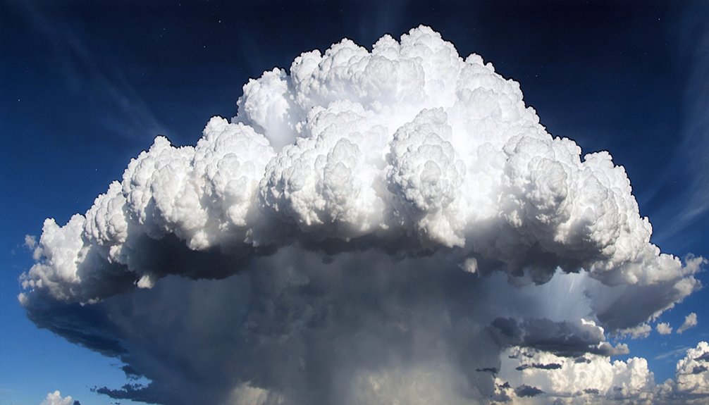
When you spot a cumulonimbus cloud towering between 40,000 and 60,000 feet with a distinctive anvil-shaped top, it’s not just an impressive sight—it’s a direct indicator of severe atmospheric instability.
A cumulonimbus reaching 60,000 feet isn’t merely dramatic—it’s the atmosphere declaring severe instability in unmistakable terms.
These cloud formation types communicate precise data about what’s happening overhead.
Vertical growth signals lightning potential and intense precipitation. Rotating updrafts within supercell structures confirm mesocyclone strength, driven by wind shear.
Mammatus formations hanging beneath the anvil indicate high instability and recent severe activity.
Effective storm prediction techniques rely on reading these structural cues accurately. A greenish or yellowish tint warns of hail. Rotating bases demand immediate shelter.
Wall clouds forming in updraft regions reveal strengthening mesocyclones. Each feature you identify gives you critical lead time to make autonomous, informed decisions before conditions deteriorate.
Early Warning Clouds That Appear Hours Before Storms
When you spot high cirrus clouds—those wispy, feathery formations streaking across the upper atmosphere—you’re seeing the first measurable indicator of an approaching warm front, often 12 to 24 hours out.
Alto Cumulus Castellanis clouds, identifiable by their small turret-like vertical extensions, signal mid-level atmospheric instability that frequently precedes organized convective storm development.
You can also track surface wind direction shifts, which typically occur 2 to 6 hours before a front arrives, giving you a precise, observable timeline to cross-reference against these cloud signals.
High Cirrus Cloud Signals
High cirrus clouds, wispy and feathery in appearance, form at altitudes above 20,000 feet and serve as one of the earliest reliable indicators of an approaching warm front.
When you spot these thin, streaked formations spreading across the sky, you’re typically looking at weather changes arriving 12 to 24 hours out. They form as moisture precedes an advancing frontal boundary at high altitudes, giving you critical lead time to prepare.
Watch for increasing coverage and thickening—when high cirrus evolves into cirrostratus, the timeline accelerates. You can track their movement direction against surface winds to confirm an incoming system.
Recognizing this progression early puts you in control, letting you act on factual atmospheric data rather than reacting to conditions already upon you.
Alto Cumulus Castellanis Indicators
While high cirrus clouds give you a 12 to 24-hour window, Alto Cumulus Castellanis (ACC) clouds compress that timeline considerably, appearing 6 to 12 hours before storm development and demanding immediate attention.
These altocumulus formations display distinctive turret-like protrusions rising from a common base, signaling mid-level atmospheric instability with precision.
You’re seeing convective cells attempting vertical development at altitudes between 6,500 and 20,000 feet. When you spot ACC clouds, storm prediction becomes actionable — you’ve got limited time to secure shelter, equipment, or travel plans.
Their cauliflower-shaped towers indicate moisture and instability combining at mid-levels, creating conditions favorable for severe thunderstorm development. Treat every ACC sighting as a direct meteorological warning, not background scenery.
Your response window is measurably shorter than with earlier cloud indicators.
Wind Direction Early Shifts
Wind direction shifts deliver one of the most reliable pre-storm signals you can detect without instruments, typically occurring 2 to 6 hours before a weather front arrives at your location.
Monitor surface wind patterns carefully — a veering shift from southerly to westerly airflow signals warm front advancement, while backing winds indicate cold front pressure. These atmospheric shifts correlate directly with observable cloud sequences overhead.
As wind patterns change, you’ll notice cirrus giving way to thickening altostratus layers. Cross-reference surface wind behavior with upper-level cloud movement; when they diverge noticeably, frontal boundaries are consolidating.
Track wind direction every 30 minutes during suspected approach windows. A sustained directional change exceeding 45 degrees within two hours confirms imminent frontal passage and demands immediate preparedness action.
Cumulonimbus Clouds and the Danger They Signal
When you spot a cumulonimbus cloud towering between 40,000 and 60,000 feet with a distinctive anvil-shaped top, you’re looking at one of nature’s most reliable severe weather indicators.
These formations signal immediate threats including thunderstorms, tornadoes, intense lightning, and heavy precipitation driven by powerful atmospheric instability.
Don’t wait to confirm worsening conditions—seek shelter immediately, as cumulonimbus presence alone marks a high-risk atmospheric environment requiring decisive action.
Identifying Cumulonimbus Cloud Threats
Cumulonimbus clouds are among the most dangerous formations you’ll encounter in storm tracking, extending from 40,000 to 60,000 feet and capped by a distinctive anvil-shaped top formed when updrafts hit the tropopause.
These cumulonimbus characteristics signal extreme atmospheric instability, producing lightning, intense precipitation, and tornado-generating mesocyclones.
You’ll assess storm intensity by monitoring vertical growth rate and anvil sharpness. A well-defined, solid anvil edge indicates an active, explosively developing system. Rapid vertical expansion confirms powerful updrafts driving severe weather potential. Greenish or dark gray coloration beneath the cloud base reinforces hail or tornado risk.
When you spot these formations, don’t wait for confirmation—seek immediate shelter. Cumulonimbus clouds operate on compressed timelines, and delayed response greatly increases your exposure to life-threatening conditions.
Dangerous Weather They Signal
Towering into the tropopause, cumulonimbus clouds drive some of the most lethal atmospheric events you’ll face in storm tracking. Recognizing cumulonimbus severity means reading every structural detail precisely.
- Anvil behavior signals active storm initiation, spreading downwind as atmospheric instability peaks.
- Wall cloud formation confirms mesocyclone strengthening and cloud rotation, demanding immediate shelter response.
- Shelf cloud characteristics mark powerful systems arriving within minutes at your position.
- Mammatus implications reveal intense turbulence and precipitation signals beneath the storm’s base.
- Moisture indicators like dark, dense ragged bases confirm significant water content driving severe outputs.
You’re tracking real threats when these features converge. Greenish hues, rotating bases, and overshooting tops confirm hail, damaging winds, or tornado potential.
Read these signals accurately—your safety depends on it.
Seeking Shelter Immediately
Once cumulonimbus clouds confirm atmospheric instability through rotating bases, greenish hues, or overshooting tops, you’ve got minutes—not hours—to reach shelter.
Wall clouds rotating beneath a mesocyclone and mammatus formations signal active severe weather demanding immediate action.
Your shelter preparedness plan must activate before conditions deteriorate. Move to an interior room on the lowest floor, away from windows. Avoid vehicles, open fields, and temporary structures—lightning strikes within 10 miles of cumulonimbus activity, and tornadoes develop with little additional warning.
Storm safety depends on recognizing these visual triggers early and acting without hesitation. Waiting for official warnings costs critical time.
When atmospheric indicators align—anvil spread, overshooting tops, rotating updrafts—trust the data the sky provides and execute your shelter plan immediately.
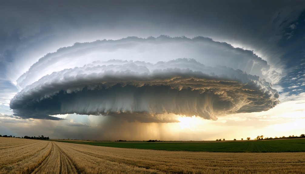
What Supercell Clouds Tell You About Tornado Risk
When you spot a supercell cloud, you’re looking at one of the atmosphere’s most dangerous storm structures. Driven by mesocyclone strength and atmospheric instability, supercells dramatically elevate tornado formation risk.
Recognizing their supercell characteristics lets you make informed, independent decisions fast.
Watch for these severe weather indicators:
- Rotating updrafts signal active cloud rotation and intensifying mesocyclone development
- Wall cloud presence confirms storm intensity and potential tornado formation below the rain-free base
- Persistent rotation lasting over 20 minutes indicates heightened atmospheric instability
- Overshooting tops reaching 60,000 feet reflect explosive updraft strength
- Wind shear alignment drives weather prediction accuracy by revealing directional storm movement
These data points aren’t abstract—they’re real-time signals giving you critical seconds to act decisively before severe weather escalates.
Anvil Clouds as Live Indicators of Storm Intensity
When you spot an anvil cloud‘s sharp, well-defined edges spreading horizontally at 40,000 to 60,000 feet, you’re observing a direct indicator of active or imminent severe weather.
You can track storm progression by monitoring how the anvil elongates downwind with upper-level steering winds, revealing both storm movement and intensification rate.
A dense, expansive anvil with crisp edges tells you the storm’s updrafts are powerful enough to push ice crystals into the tropopause, confirming high atmospheric instability and immediate severe weather potential.
Anvil Shape Signals Severity
Anvil clouds serve as live barometers of storm intensity, giving you real-time data on what a thunderstorm is doing at its core. Tracking anvil characteristics lets you assess storm severity before conditions deteriorate.
Watch for these structural signals:
- Sharp, well-defined edges indicate an actively intensifying storm pushing into the upper atmosphere.
- Elongated downwind spread confirms upper-level steering winds are accelerating storm progression.
- Overshooting tops piercing the anvil signal extreme updraft strength and tornado potential.
- Below-anvil cirrus plumes streaming outward warn of large hail or damaging wind production.
- Ragged, fragmented anvil edges suggest a weakening storm losing organizational structure.
Each anvil characteristic delivers measurable intelligence. You don’t need instruments to read these signals — the sky gives you the data directly.
Tracking Storm Progression Visually
Once you’ve identified an anvil cloud, tracking its structural changes over time transforms it into a live storm intensity indicator.
Watch the anvil’s leading edge — a sharp, well-defined boundary signals an actively intensifying storm, while a fuzzy or diffuse edge indicates weakening.
During storm tracking, note the anvil’s elongation direction; it follows upper-level steering winds, revealing storm movement vectors.
If overshooting tops repeatedly punch through the anvil’s flat base, the updraft is exceptionally strong, raising tornado and large hail probabilities considerably.
Cloud identification becomes dynamic here — mammatus formations appearing on the anvil’s underside confirm severe downdrafts are active.
Monitor these structural shifts every 10 to 15 minutes. Rapid anvil expansion paired with persistent overshooting tops demands immediate protective action.
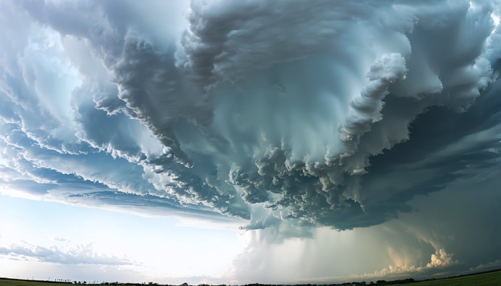
What Mammatus Clouds Reveal About Nearby Severe Weather
Mammatus clouds signal recent or ongoing severe storm activity, making them a critical visual cue for storm trackers. Their pouch-like structures hanging beneath cloud bases indicate high atmospheric instability.
Recognizing mammatus formation significance lets you assess severe weather implications quickly and accurately.
Watch for these key indicators:
- Pouch-like formations hanging from anvil bases confirm active severe storm cells nearby
- High instability levels revealed by mammatus suggest turbulent downdrafts dominating the atmosphere
- Proximity to anvil clouds means severe weather arrival within hours
- Dense clustering patterns indicate intensifying storm strength requiring immediate shelter consideration
- Rapid formation speed signals accelerating atmospheric instability demanding your immediate attention
You can’t afford to ignore mammatus clouds. They’re nature’s direct warning that severe weather is either overhead or approaching fast.
Shelf Clouds vs. Wall Clouds: What’s the Difference?
While mammatus clouds warn you of severe weather developing aloft, shelf and wall clouds deliver ground-level confirmation that dangerous storm systems are actively organizing around you.
Shelf cloud formation occurs at a storm’s leading edge, appearing as a low, horizontal wedge attached to the rain-free base. It signals powerful winds and precipitation arriving within minutes.
Wall cloud characteristics differ considerably. Wall clouds form in the updraft region on a storm’s trailing side, descending noticeably below the base. When rotation develops within a wall cloud, you’re observing mesocyclone intensification—a direct tornado precursor demanding immediate shelter.
Key distinctions: shelf clouds indicate storm arrival from the front; wall clouds indicate structural strengthening from the rear.
Recognizing both formations gives you precise, actionable intelligence about severe weather timing and intensity.
Color and Texture Clues That Expose a Storm’s Severity
Beyond cloud shape and position, color and texture reveal critical data about a storm’s internal dynamics. You can read these color cues and texture signals like a real-time severity report:
- Dark gray to near-black bases indicate dense moisture concentration and imminent heavy precipitation.
- Greenish or yellowish tints signal suspended hail within the storm’s core, confirming severe conditions.
- Ragged, torn cloud edges reflect violent turbulence and strong internal wind shear activity.
- Dense, smooth anvil surfaces with sharp boundaries confirm active, energized updrafts driving storm intensification.
- Mammatus pouches displaying deep contrast and defined structure indicate recent explosive convective activity overhead.
You don’t need instruments to assess initial threat levels. These visual markers deliver actionable intelligence, letting you make fast, informed decisions before conditions deteriorate.
How Cloud Movement Exposes an Approaching Storm System
Cloud movement delivers real-time data about storm approach that static observation can’t capture. When you track cloud direction against surface winds, you’re reading a critical atmospheric signal.
Clouds moving contrary to ground-level winds indicate converging weather systems closing in within hours.
You’ll want to monitor upper-level cloud layers moving faster than lower formations—this wind shear accelerates storm pattern development and fuels rotating supercells.
Rapid directional shifts in cumulus movement signal instability surges preceding severe weather by 2 to 6 hours.
Watch anvil clouds spreading downwind; their elongation direction maps the storm’s trajectory precisely.
When multiple cloud layers travel different directions simultaneously, atmospheric instability is escalating fast.
Reading these movement vectors gives you actionable intelligence, letting you make informed decisions before conditions deteriorate.
How to Time a Storm’s Arrival by Reading Cloud Formations
Timing a storm’s arrival comes down to reading 3 distinct cloud layers in sequence. Master cloud interpretation and you’ll track storm timing with precision.
- High cirrus clouds appear 12–18 hours before frontal arrival.
- Alto Cumulus Castellanus turrets signal mid-level instability 6–12 hours out.
- Wind direction shifts confirm frontal approach within 2–6 hours.
- Shelf clouds indicate powerful storm systems arriving within minutes.
- Mammatus and anvil formations confirm severe weather is actively overhead.
Watch each layer shift systematically. When cirrus gives way to thickening mid-level clouds, your window narrows fast.
Rotating wall clouds compress your response time to seconds, not hours. You’re not guessing—you’re executing a sequential read of atmospheric data.
Each cloud layer hands you actionable intelligence. Use it.
Frequently Asked Questions
Can Cloud Formations Help Predict Storm Intensity Days in Advance?
You can’t reliably use cloud characteristics for storm prediction days in advance. Cloud formations typically signal severe weather hours ahead, not days, giving you precise, actionable warnings within a 2-to-6-hour window before fronts arrive.
How Do Atmospheric Pressure Changes Relate to Cloud Formation Patterns?
Like a barometer whispering secrets, you’ll notice cloud pressure shifts 12-18 hours before storms. Atmospheric dynamics drive rising air, triggering cumulus growth and cumulonimbus development, signaling instability you can’t ignore.
Are Certain Cloud Formations More Common in Specific Geographic Regions?
Yes, you’ll find tropical clouds bring cumulonimbus clusters, mountain clouds trigger orographic lifting, coastal clouds form marine layers, urban clouds reflect heat islands, polar clouds stay stratiform, and desert clouds remain sparse and isolated.
Can Animals Sense Approaching Storms Before Visible Cloud Formations Appear?
Ironically, you don’t need eyes in the sky — animals do it better. You’ll notice animal behavior shifting 12–18 hours early, mirroring atmospheric pressure storm signals your joints already feel but your freedom-loving instincts ignore.
How Do Seasonal Changes Affect the Reliability of Cloud Storm Indicators?
Seasonal patterns directly affect cloud indicators’ reliability. In summer, you’ll find cumulonimbus formations more frequent and intense. Winter reduces convective activity, making anvil and mammatus clouds rarer. Always adjust your storm-tracking interpretations based on prevailing seasonal atmospheric conditions.
References
- https://crazystormchasers.com/understanding-cloud-formations-for-storm-tracking/
- https://photosofnorfolk.co.uk/when-the-going-gets-tough/tracking-a-storm/
- https://www.farmersalmanac.com/crazy-clouds-understanding-unusual-sky-formations
- https://crazystormchasers.com/analyzing-atmospheric-conditions-for-storm-tracking/
- https://www.youtube.com/watch?v=B6Q6v25WK3I
- https://www.weather.gov/media/unr/SpottersGuide2011_fielduse.pdf
- https://www.youtube.com/watch?v=HlTJzcJKV-k
- https://weatherology.com/trending/articles/Professor-Paul-Severe-Weather-Cloud-Identification.html
- https://news.climate.columbia.edu/2015/09/08/bringing-together-storm-tracks-and-clouds/
- https://www.pathsoflearning.net/14568/how-to-understand-weather-patterns-through-outdoor-observation/


