Preparation is essential for chasing supercell storms because these systems can turn lethal within seconds. You’re dealing with tornadoes, large hail, damaging winds, and flash flooding happening simultaneously. Without mapped escape routes, a stocked emergency kit, and analyzed forecasts, you’re reacting instead of anticipating—and supercells punish reactive decisions fatally. HP supercells hide tornadoes inside rain curtains, eliminating your visual warning. Every preparation layer you add increases your survival margin, and there’s much more you’ll want to know before you chase.
Key Takeaways
- Supercells simultaneously produce tornadoes, large hail, damaging winds, and flash flooding, making preparation critical for surviving multiple hazards at once.
- HP supercells conceal tornadoes within rain curtains, eliminating visual confirmation and transforming unprepared chasers’ calculated risks into deadly traps.
- A stocked emergency kit with water, food, flashlights, and a NOAA radio ensures survival when cell service fails.
- Pre-chase forecasting and escape route mapping prevent reactive decision-making during rapid, life-threatening storm condition changes.
- Spotter training sharpens real-time storm assessment, reducing dangerous misidentification of tornadoes and enabling safer positioning and escape planning.
What Makes Supercell Storms So Dangerous?
Supercells rank among the most destructive storm systems on Earth, and they’re dangerous because of how efficiently they concentrate hazardous energy.
Understanding supercell dynamics means recognizing that these storms require four precise ingredients: atmospheric instability, moisture, lift, and strong wind shear. That shear causes winds to veer and accelerate with height, generating a rotating updraft called a mesocyclone.
Supercells demand four precise ingredients — and when they align, a rotating mesocyclone becomes almost inevitable.
Storm structure in a supercell differs fundamentally from ordinary thunderstorms. You’re dealing with a self-sustaining engine capable of producing violent tornadoes, large hail, damaging straight-line winds, and flash flooding simultaneously.
HP supercells add another threat layer by wrapping precipitation around the updraft, concealing tornadoes inside rain curtains. You can’t see the danger until it’s already upon you, which is precisely what makes preparation non-negotiable before you ever approach one.
The Preparation Failures That Turn Storm Chases Fatal
When you skip mapping your escape routes before engaging a supercell, you transform a calculated risk into a death trap, since storm motion shifts can cut off your exit in seconds.
You must never underestimate HP supercells, which wrap tornadoes inside rain curtains that eliminate visual confirmation until it’s too late to maneuver.
Without a fully stocked emergency kit—water, first aid supplies, a NOAA weather radio, and backup batteries—you’re compounding every other preparation failure into a potentially fatal chain of errors.
Ignoring Escape Route Planning
Failing to plan escape routes before engaging a supercell is one of the most common—and most lethal—preparation failures in storm chasing. You can’t improvise your way out when storm dynamics shift unexpectedly.
Supercells accelerate, turn, and expand their threat zones faster than unprepared chasers can react. Before you approach any storm, identify your escape route on detailed road maps.
Account for dead-end roads, bridges that flood rapidly, and rural areas with limited exits. You should stair-step southeast as your primary escape strategy, moving perpendicular to the storm’s forward motion.
HP supercells are especially unforgiving—rain-wrapped tornadoes eliminate visual warnings, leaving you no reaction time. Your freedom to chase safely depends entirely on committing your exit strategy before you’re ever in danger.
Underestimating HP Supercell Dangers
HP supercells don’t just raise the danger level—they rewrite the rules of engagement entirely.
Rain-wrapped tornadoes eliminate visual confirmation, stripping away your primary warning system. HP supercell misconceptions kill chasers who apply standard positioning strategies to fundamentally different storm architectures.
You can’t trust what you can’t see. Flash flooding threatens escape routes you’ve already committed to. The forward and rear flank downdrafts shift precipitation unpredictably, boxing you in without warning.
Storm chase myths suggest experience alone compensates for HP-specific hazards. It doesn’t. Even veteran spotters recalibrate their entire approach when HP storms develop.
You must identify HP characteristics during forecast analysis, not after you’ve entered the precipitation core. Recognizing that distinction before deployment is what keeps your freedom to chase intact.
Neglecting Emergency Kit Essentials
Misreading an HP supercell can strand you in a rain-wrapped kill zone faster than any other storm type—but surviving that scenario depends entirely on what’s in your kit when everything else fails.
Neglecting emergency kit essentials isn’t a minor oversight—it’s a fatal one. Your storm chase preparation must include water, food, flashlights, fresh batteries, a first aid kit, prescription medications, and a dedicated NOAA weather radio.
Don’t rely on cell service; it fails precisely when you need it most. Your weather radio operates independently, delivering critical warnings when towers go down.
Every item earns its place by solving a specific survival problem. Pack deliberately, audit your kit before each chase, and treat preparation as non-negotiable—because in a HP supercell scenario, it absolutely is.
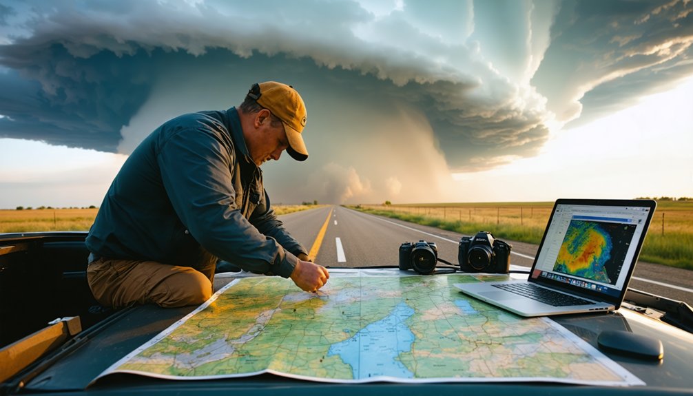
Read Forecasts Before You Ever Leave Home
Before you chase a single storm, you’ll need to immerse yourself in forecast products from the Storm Prediction Center and the National Weather Service days in advance.
Forecast accuracy depends on your ability to analyze synoptic setups, mesoscale discussions, and convective outlooks well before you load your gear. Storm tracking isn’t reactive—it’s deliberate, beginning at your desk, not your windshield.
Monitor NOAA Weather Radio, reliable weather apps, and NWS products consistently.
Identify where instability, moisture, and shear intersect to produce supercell potential. Anticipate multiple storm scenarios so you’re not scrambling when conditions evolve rapidly.
Understanding storm motion, watch issuances, and warning timelines gives you the strategic edge to position safely and effectively.
You’ll chase smarter when preparation starts long before departure.
Build a Safety Plan Around How Supercells Move
Once you’ve studied the forecast and identified your target area, your next step is building a safety plan that accounts for how supercells actually move across the landscape.
Understanding supercell dynamics means recognizing that storms typically track northeast, but directional shifts happen fast. You’ll need predetermined escape routes oriented southeast, letting you stair-step away from a threatening storm without scrambling.
Supercells shift direction fast — know your southeast escape routes before the storm decides to turn.
Storm tracking isn’t passive observation — it demands constant reassessment. Know your roads before you’re in the field.
Identify multiple exit paths, account for terrain, and anticipate where a right-turning supercell could cut off your retreat.
Forecast several movement scenarios in advance so you’re responding to a plan, not reacting to panic. Your freedom to chase safely depends entirely on preparation executed before you ever reach the storm.
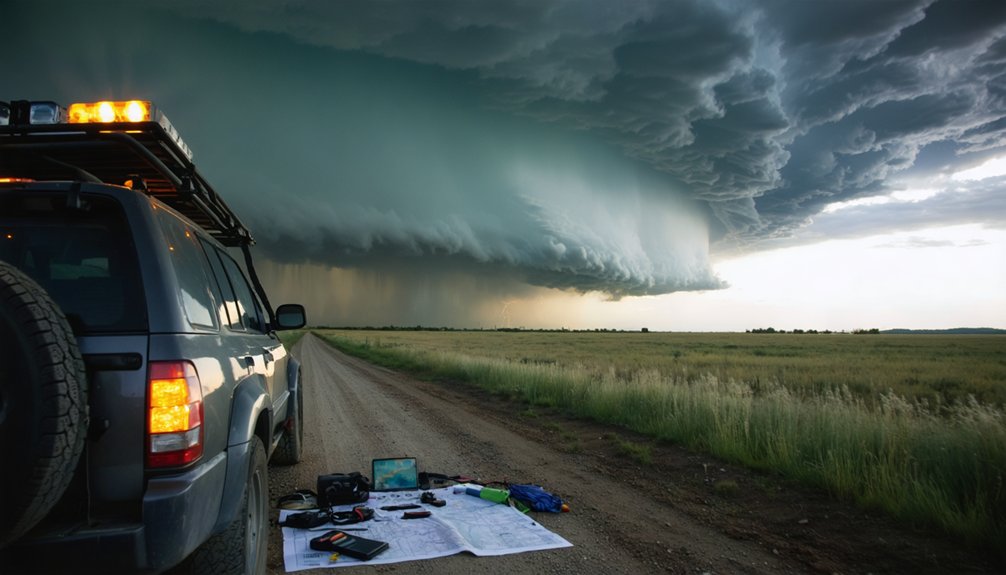
What to Have Ready in Your Vehicle Before You Chase
Before you pull out to intercept a supercell, stock your vehicle with a core emergency kit containing water, food, a first aid kit, extra batteries, and a NOAA weather radio.
Pair that kit with reliable navigation tools—detailed current maps, a GPS unit, and a charged communication device—so you can assess storm behavior and adapt your positioning in real time.
Finally, run a vehicle safety checklist covering fuel level, tire condition, and clear sight lines, because a mechanical failure near an HP supercell or rain-wrapped tornado leaves no margin for error.
Essential Emergency Supply Kit
Every storm chaser needs seven core supplies staged and accessible in their vehicle before they ever leave for a chase: water (at least one gallon per person per day), non-perishable food, a battery-powered or hand-crank NOAA Weather Radio, flashlights with spare batteries, a first aid kit, any personal medications, and a fully charged mobile device loaded with reliable radar apps.
Supply essentials mean nothing if you can’t access them quickly under pressure. Kit organization is non-negotiable — store items in clearly labeled, dedicated containers within immediate reach.
Keep your weather radio separate from other electronics and verify battery levels before departure. Restock consumables after every chase. Your ability to operate independently in the field depends entirely on what you’ve already secured before the storm forms.
Reliable navigation and communication tools aren’t optional accessories — they’re operational infrastructure.
Before you chase, load multiple navigation apps onto your device — redundancy matters when cell coverage drops. Pair digital mapping with a physical road atlas; digital systems fail under pressure.
Mount a dedicated weather radio for emergency alerts independent of internet connectivity. Communication devices should include a ham radio license and transceiver, enabling direct contact with spotters and local NWS offices delivering real-time updates you won’t find elsewhere.
For storm tracking, run a radar application with minimal latency — every second of delay distorts your positional decisions. Cross-reference storm movement data against your navigation apps to identify safe routes before conditions deteriorate.
You control your outcome only when your tools communicate faster than the storm moves.
Vehicle Safety Equipment Checklist
Your navigation and communication stack keeps you informed — your vehicle safety equipment keeps you alive when information alone isn’t enough.
Before you chase, complete your vehicle maintenance: check tire pressure, fluid levels, brakes, and fuel. A mechanical failure near a supercell isn’t inconvenient — it’s potentially fatal.
Your safety gear loadout should include a certified helmet, safety glasses, sturdy boots, and high-visibility vest.
Pack a first aid kit, fire extinguisher, emergency blanket, and a seatbelt cutter with window breaker. Keep a physical paper map as a backup navigation fail-safe.
Store gear in accessible, organized locations — not buried under clutter. You’ll need to move fast.
Prioritize redundancy, functionality, and speed of access over everything else. Your vehicle is your lifeline; treat it accordingly.
How to Position Safely Near a Supercell
Positioning safely near a supercell demands a clear understanding of storm motion and structure before you ever leave your vehicle.
You’ll want to place yourself southeast of the storm, looking northwest toward the mesocyclone. This storm positioning keeps you ahead of the forward flank downdraft and away from the primary threat corridor.
Maintain a safe distance that gives you time to react if the storm shifts unexpectedly. You should stair-step southeast using a grid road network, preserving multiple escape routes.
Never commit to a single road when the storm’s forward motion could cut off your path.
HP supercells require extra caution since rain-wrapped tornadoes eliminate visual warnings.
Always forecast alternate scenarios before approaching, so you’re never forced into reactive, pressure-driven decisions.
Why HP Supercells Are the Most Dangerous Storm You’ll Chase
HP supercells take every positioning challenge you’ve just read about and amplify it with one defining threat: you can’t see what’s trying to kill you.
Rain-wrapped tornadoes eliminate your visual advantage, burying tornado formation dynamics inside precipitation walls that storm structure analysis can’t fully penetrate from the field.
Wind shear impacts intensify mesocyclone characteristics, tightening rotation while HP supercell hazards compound simultaneously — violent winds, destructive hail, and flash flood risks converging without warning.
Severe weather patterns associated with HP storms make southeastern positioning nearly impossible because precipitation wraps completely around the updraft.
You lose your escape corridor when you can’t read the storm. These systems demand your most disciplined decision-making.
If you can’t confirm what’s inside that rain curtain, you don’t drive into it.
Why Spotter Training Makes Supercell Chasing Safer
Everything you’ve read about supercell structure, HP hazards, and positioning strategy becomes actionable knowledge once spotter training formalizes it.
Training sharpens your spotter techniques, teaching you to interpret visual cues like wall clouds, rotating updraft bases, and rear flank downdraft clearing with precision rather than guesswork. You’ll distinguish actual tornadoes from rain curtains, dust whirls, and scud, reducing costly misidentification in the field.
Precision identification separates competent spotters from guessers—training teaches you to read what the storm is actually telling you.
Training also integrates NWS communication protocols, making your reports operationally useful rather than anecdotal.
You’ll learn severe storm physics, hazard zones, and scenario-based decision frameworks that eliminate hesitation when conditions deteriorate rapidly. That structured preparation directly translates to safer positioning, smarter escape route planning, and confident real-time assessment—exactly the competencies that separate disciplined chasers from dangerous ones.
Frequently Asked Questions
How Does Wind Shear Affect Supercell Storm Structure and Tornado Formation?
Wind shear drives supercell dynamics by rotating updrafts into mesocyclones, fueling tornado formation. You’ll see vertical wind variations tilt storm structure, while atmospheric instability amplifies rotation, creating conditions where powerful, violent tornadoes can violently emerge.
What Visual Differences Separate Real Tornadoes From Tornado Look-Alikes?
Think you can spot a tornado? Real tornadoes display distinct tornado features: rotating condensation funnels, debris clouds, and continuous ground contact. You’ll use visual cues like persistent circulation and dirt swirls to distinguish them from scud or gustnadoes.
How Do Rear Flank Downdrafts Influence Precipitation Placement Around Supercells?
Rear flank downdrafts drive precipitation patterns by wrapping rain and hail around the updraft. You’ll notice downdraft dynamics push moisture cyclonically, creating HP supercells’ dangerous rain-wrapped tornadoes, complicating your visual identification and greatly increasing your situational awareness challenges.
What Role Do Storm Spotters Play in Improving National Weather Service Warnings?
Like sentinels guarding a city, you serve as the NWS’s eyes on the ground. Your storm spotter training delivers real-time reports that sharpen warning accuracy, helping forecasters interpret radar and issue life-saving alerts faster.
How Do Veering Winds Create the Mesocyclone Inside a Supercell Thunderstorm?
Veering winds drive mesocyclone dynamics by rotating clockwise with height, stretching air vertically into a spinning column. You’ll see wind veering transform horizontal rotation into the supercell’s powerful, organized mesocyclone, fueling tornado potential.
References
- https://moffittservices.com/prepare-for-the-supercell-thunderstorm/
- https://www.wunderground.com/prepare/supercell
- https://www.weather.gov/oun/stormspotting
- https://time.com/7317970/storm-chasing-weather-leadership-lessons/
- https://stormtrack.org/threads/best-way-to-approach-a-storm-supercell.12165/
- https://www.comet.ucar.edu/increasing-awareness-and-understanding-severe-weather-through-storm-chasing-education


