Chasing supercell storms puts you face-to-face with the most organized and violent thunderstorms on Earth. You’ll encounter rotating mesocyclones, baseball-sized hail, and long-track tornadoes that ordinary storms can’t produce. To do it safely, you’ll need radar literacy, proper gear, and smart field positioning. Understanding wind shear mechanics and hook echo signatures transforms raw experience into informed decision-making. Master these fundamentals, and everything about safely intercepting supercells — from gear selection to escape route planning — starts clicking into place.
Key Takeaways
- Supercells are the most violent thunderstorms, producing baseball-sized hail and long-track tornadoes, making them compelling subjects for scientific observation and study.
- Radar tools help chasers identify hook echoes and velocity couplets, enabling real-time tracking of dangerous supercell rotation and potential tornado development.
- Essential gear, including weather radios, GPS devices, and communication apps, ensures chasers stay informed and navigate safely during rapidly evolving storm conditions.
- Safe field positioning requires maintaining one-mile distance from tornadoes, staying southeast of the mesocyclone, and always having two pre-planned escape routes ready.
- Guided storm chasing tours accelerate beginners’ learning by providing expert radar interpretation, optimal storm positioning, and critical real-time risk assessment experience.
What Makes Supercell Storms Worth Chasing
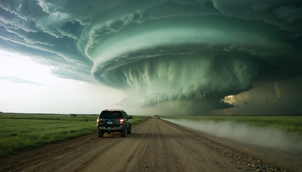
Supercells represent the most organized and violent class of thunderstorm on Earth, capable of producing baseball-sized hail, damaging straight-line winds, and long-track tornadoes that can persist for hundreds of miles. Their defining supercell characteristics include a persistent rotating updraft called a mesocyclone, which distinguishes them from ordinary convective storms.
You’re not just watching weather unfold — you’re witnessing an atmospheric engine operating at peak intensity.
Storm chasing excitement stems from more than adrenaline. Supercells offer unmatched visual spectacle: structured wall clouds, dramatic inflow bands, and explosive anvil formations that reward careful observation.
Each chase sharpens your forecasting instincts, radar interpretation, and real-time decision-making. You gain direct experience that no classroom replicates.
For those who value raw engagement with natural forces, supercells deliver that experience with uncompromising intensity.
Why Supercells Rotate and Other Storms Don’t
What separates supercells from ordinary thunderstorms isn’t raw power — it’s rotation, and that rotation originates from wind shear in the surrounding atmosphere.
When winds change speed and direction with altitude, they create invisible horizontal vortices rolling through the atmosphere. A powerful updraft tilts these vortices vertically, embedding them within the storm’s core. That process defines supercell dynamics — a self-sustaining system where rotation strengthens the updraft, and the updraft reinforces rotation.
Ordinary thunderstorms lack sufficient wind shear to initiate this feedback loop. Without it, they rise, mature, and collapse without ever developing a mesocyclone.
Storm rotation transforms a supercell into something fundamentally different — an organized, persistent engine capable of producing tornadoes, large hail, and extreme winds. That distinction is precisely why supercells command serious attention from chasers.
How to Read Storm Chasing Radar Like a Pro
Once you’ve got a handle on supercell structure, radar becomes your most critical real-time tool, displaying storm intensity, precipitation, and rotation through reflectivity and velocity products.
You’ll want to master hook echo signatures first—that distinctive curved appendage on the southwestern flank of a supercell indicating rotation and potential tornado development.
From there, shift your focus to velocity couplets, where adjacent zones of inbound and outbound winds confirm mesocyclone rotation and, in stronger signatures, may indicate an imminent tornado vortex signature (TVS).
Understanding Basic Radar Features
Three core radar features separate effective storm chasers from those flying blind in the field: hook echoes, velocity couplets, and tornado vortex signatures (TVS).
Mastering these radar basics transforms storm tracking from guesswork into calculated pursuit.
Hook echoes appear on reflectivity scans as curved precipitation appendages wrapping around a supercell’s mesocyclone, signaling active rotation.
Velocity couplets display contrasting wind directions within tight proximity, confirming rotational intensity.
TVS signatures indicate concentrated vorticity consistent with imminent tornado development.
You’ll want to cross-reference these features rather than relying on any single indicator.
Distant storms present radar limitations due to beam elevation, so supplement your radar basics with surface observations and satellite data.
Combining these inputs gives you the complete situational awareness necessary for confident, independent storm tracking decisions.
Identifying Hook Echo Signatures
Hook echoes rank among the most recognizable and reliable supercell signatures you’ll encounter on radar, and learning to read them precisely separates confident positioning from costly guesswork.
Hook echo identification begins with recognizing the distinctive appendage wrapping around a supercell’s southern or southwestern edge, indicating rotating inflow drawing precipitation into the mesocyclone. This curved extension marks the boundary between inflow and the rear flank downdraft region.
Mastering supercell characteristics means cross-referencing the hook’s shape with velocity data simultaneously. A tight, well-defined hook paired with a strong velocity couplet confirms active rotation and elevates tornado probability considerably.
Wider, diffuse hooks suggest weaker organization. You’ll want RadarScope or GRLevel2 to examine base reflectivity alongside storm-relative velocity, giving you complete structural context before committing to any positioning decision.
Reading Velocity Couplets Effectively
Velocity couplets reveal the rotational intensity within a supercell by displaying adjacent areas of inbound and outbound winds on storm-relative velocity products, and reading them accurately determines whether you’re looking at a disorganized storm or an imminent tornado producer.
For effective velocity couplet interpretation, locate the tight color contrast zones—typically red adjacent to green on standard displays—where extreme values appear closest together. Tighter couplets with greater velocity differentials indicate stronger storm rotation analysis results, signaling elevated tornado potential.
Pay attention to couplet depth; rotation extending through multiple elevation scans confirms a well-organized mesocyclone rather than shallow, surface-level spin.
When velocity differentials exceed 90 knots across a compact area, you’re observing a genuinely dangerous storm demanding immediate positional reassessment and escape route confirmation.
Essential Gear Every Beginner Storm Chaser Needs

When you head into the field, you’ll need a weather radio and a ham radio license with a handheld transceiver to maintain communication when cell networks fail.
Pair these with a dedicated GPS device—don’t rely solely on your smartphone, which can lose signal or battery power at critical moments.
Together, reliable communication tools and precise navigation equipment form the operational backbone of every safe and effective chase.
Must-Have Communication Devices
Three essential communication devices belong in every beginner storm chaser’s kit: a NOAA weather radio, a ham radio, and a reliable cell phone with redundant data access. Each device serves a distinct operational role you can’t afford to overlook.
Your NOAA radio delivers continuous National Weather Service alerts independent of cellular infrastructure. When towers fail during severe weather, you’ll still receive critical warnings.
Ham radio connects you directly with trained spotters and emergency protocols networks, giving you ground-truth intelligence radar can’t provide.
Load your cell phone with proven communication apps like Zello and SpotterNetwork before you deploy. These platforms integrate spotter reports with real-time positioning data.
Redundant data access—using dual carriers or a mobile hotspot—ensures connectivity when a single carrier’s network becomes overwhelmed during active severe weather events.
Beyond your communication stack, reliable navigation tools keep you oriented and moving safely relative to a storm’s unpredictable track. GPS accuracy deteriorates when you’re improvising escapes on unfamiliar rural roads, so dedicate a device exclusively to navigation apps with offline map overlays loaded before you deploy.
- Route planning: Pre-load multiple exit corridors using apps like Google Maps or Waze, cross-referenced against storm tracking data.
- Real time updates: Sync mobile connectivity with weather alerts to dynamically reroute around flooding or core precipitation.
- Redundancy: Carry a standalone GPS unit independent of cell service, ensuring continuous positioning when networks fail.
Combining layered map overlays with live storm tracking positions you to intercept supercells confidently while maintaining the freedom to exit on your own terms.
What Storm Chasers Actually See in the Field
Stepping into the field for the first time, you’ll quickly discover that real supercells rarely match the clean, symmetrical diagrams found in textbooks. Storm behaviors shift rapidly, and cloud formations appear chaotic, layered, and dramatically three-dimensional.
You’ll observe wall clouds rotating beneath the storm’s base, inflow tails feeding moisture into the updraft, and clear slots cutting through precipitation as the rear flank downdraft wraps around the mesocyclone.
Colors matter greatly. Greenish skies indicate large hail aloft, while contrast between the updraft tower and surrounding clouds signals intense convective energy.
You’ll hear roaring winds, detect sudden atmospheric pressure changes, and feel temperature drops as the storm evolves. These sensory inputs, combined with your radar knowledge, transform raw observations into actionable situational awareness, keeping you both informed and free to reposition decisively.
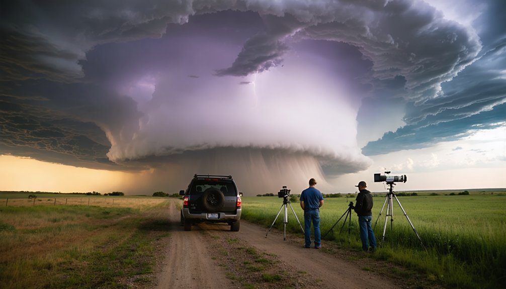
How Storm Chasers Position Safely Near a Tornado
Once you’ve identified a tornado-producing supercell, positioning becomes your most critical decision. Safe positioning requires maintaining at least one mile from the tornado while staying south or southeast of the mesocyclone.
Tornado proximity increases exponentially when you’re north or northeast of the storm’s core—avoid those angles entirely.
Prioritize these non-negotiable positioning principles:
- Escape routes first: Identify two viable exit roads before committing to any observation point
- Avoid the bear’s cage: Never position northeast of the hook echo where rain-wrapped tornadoes hide
- Monitor rear flank downdraft: A clearing slot signals rapid storm evolution requiring immediate repositioning
Your vehicle should always face away from the tornado, engine running. Conditions change within seconds—disciplined positioning keeps you observing rather than fleeing blindly.
The Biggest Hazards Beginner Storm Chasers Underestimate
Positioning safely near a tornado demands your full attention, but fixating solely on the funnel itself leaves you blind to the hazards that actually injure and kill most beginner chasers.
Storm myths convince you the tornado is your primary threat. It rarely is. Hail the size of baseballs strikes without warning, shattering windshields and disabling your vehicle instantly.
Storm myths lie. The tornado isn’t your greatest threat — a baseball-sized hailstone through your windshield is.
Flash flooding cuts off rural escape routes faster than most chasers anticipate, trapping them on roads that become rivers within minutes.
Lightning strikes independently of the tornado’s location. Safety misconceptions lead beginners to underestimate these distributed threats while tunnel-visioning on the visible funnel.
You must continuously monitor road conditions, watch for rising water, and maintain multiple exit routes.
Survival depends on managing every hazard simultaneously, not just the one you’re photographing.
Should You Start Storm Chasing on a Guided Tour?
Why attempt independent storm chasing before you understand what you’re looking at? Guided tour benefits extend beyond convenience—they accelerate your learning curve while prioritizing beginner safety.
Experienced guides handle:
- Storm positioning — placing you within ideal viewing range while maintaining escape routes
- Real-time interpretation — explaining radar signatures, hook echoes, and mesocyclone development as they unfold
- Risk assessment — making critical go/no-go decisions based on storm behavior you haven’t yet learned to read
You’re not surrendering autonomy by starting with a tour—you’re investing in foundational competence.
Independent chasing requires forecasting skills, radar literacy, and situational awareness that take years to develop. A guided experience compresses that timeline, letting you observe supercells safely while building the knowledge base you’ll eventually chase on your own.
Frequently Asked Questions
How Does Wind Shear Vary Across Different Regions Outside Tornado Alley?
Wind shear dynamics shift dramatically outside Tornado Alley — over 60% of global supercells form in unexpected regions. You’ll find regional variations across Europe, Australia, and South America, where unique topography and atmospheric conditions create equally powerful wind shear environments.
Can Storm Chasing Negatively Impact Local Communities or Emergency Response Efforts?
Yes, you can negatively impact community safety by blocking evacuation routes or overwhelming emergency resources. Maintain radio awareness, avoid congested roads during active tornado warnings, and never interfere with first responders managing disaster zones.
What Physical Fitness Level Is Recommended Before Attempting Storm Chasing Activities?
You’ll need solid cardiovascular endurance to handle prolonged outdoor exertion and rapid repositioning. Incorporate strength training to manage heavy equipment. Maintain overall fitness ensuring you’re physically capable of swift, independent movement during dynamic, fast-changing storm scenarios.
How Do Professional Storm Chasers Fund Their Expeditions and Equipment Purchases?
You’ll fund expeditions through sponsorships, media licensing, guided tour fees, and crowdfunding strategies targeting enthusiast communities. Prioritize equipment maintenance budgets alongside operational costs to protect your investment and sustain long-term, financially independent storm chasing pursuits.
Are There Legal Permits or Licenses Required for Storm Chasing in Certain States?
Sirens wail, skies darken — yet you’re free to chase. Storm chasing regulations don’t require state-specific permits nationally, but you’ll encounter local road closures and emergency management restrictions that demand your immediate, informed compliance.
References
- https://www.youtube.com/watch?v=6otZLjSZvPU
- https://www.gabegarfield.com/blog/zerotohero
- https://www.livingskytours.com/storm-chasing-guide/
- https://www.stormchasingusa.com/blog/beginners-guide-to-storm-chasing-with-organized-tours/
- https://www.youtube.com/watch?v=VkpadCUGaVA
- https://www.naturettl.com/how-to-photograph-storms-supercells-lightning-tornadoes/


