New research is reshaping how you chase storms at every decision point. Drone platforms like RAAVEN now map hail swaths at 120 feet, compressing your intercept cycles with measurable precision. ICECHIP’s multi-source datasets reduce forecast uncertainty by integrating radar-confirmed updraft data with hailstone strength measurements. You’re cross-referencing real-time Doppler signatures against low-level shear analysis to determine when waiting ends and pursuit begins. The full tactical picture goes much deeper.
Key Takeaways
- ICECHIP dataset integrates multi-source storm data, reducing forecast uncertainty and improving hail swath predictions for safer storm chasing approaches.
- Drone technology like RAAVEN maps hail swaths at 120 feet, compressing decision cycles and enabling more precise storm interception strategies.
- Real-time radar signatures from Doppler on Wheels trucks validate ground observations, enhancing understanding of hailstorm cores and updraft dynamics.
- Storm-relative helicity monitoring signals directional changes, helping chasers anticipate storm behavior shifts in fast-moving environments like Dixie Alley.
- Shear analysis now directly informs pursuit decisions, with insufficient low-level shear triggering holding positions and confirmed organization prompting active movement.
How Drone and Radar Tech Is Reshaping Chase Decisions
As storm chasing grows more data-intensive, drones and portable radar systems are fundamentally changing how teams make real-time decisions in the field.
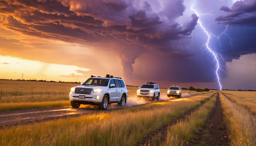
You’re no longer relying solely on instinct—drone capabilities like RAAVEN now let you map hail swaths at 120 feet altitude, capturing precise ice trail widths behind a storm’s rear flank. Real-time camera feeds give you immediate visual data without direct exposure to impact zones.
Drones like RAAVEN map hail swaths at altitude, delivering real-time visual data without placing you inside the impact zone.
Radar advancements through Doppler on Wheels trucks let you swivel portable units directly into hailstorm cores, confirming updraft structures you’ve already observed visually. Vehicles fitted with mesh canopies protect your equipment during active deployments, extending operational windows.
Together, these technologies compress decision cycles, letting you navigate storm environments with measurable precision rather than approximation.
Reading Shear and Updrafts During Active Storm Chases
Technology only gets you so far—what you observe on radar and drone feeds still needs interpretation through atmospheric dynamics. During active chases, your shear analysis determines whether a storm organizes into a supercell or collapses entirely. Insufficient low-level shear disrupts rotation despite promising outbreak forecasts, so you’re constantly recalibrating positioning decisions.
Updraft identification sharpens your read on storm potential. When radar confirms the vigorous vertical motion you’re visually tracking, you’ve got actionable data. You compare real-time radar signatures against what you’re seeing at ground level, validating or contradicting your initial assessment.
Environmental shear directly controls storm speed and structure, particularly in high-velocity environments like Dixie Alley, where 50-60 knot storm speeds demand precise, chess-like navigation.
Mastering both dynamics gives you genuine tactical freedom in the field.
What ICECHIP’s Hail Data Means for Storm Chasers
When you’re positioning a chase vehicle near a hailstorm core, ICECHIP’s dataset—the largest U.S. hail study in 40 years—gives you something previous campaigns couldn’t: a holistic, multi-source picture of what’s actually happening inside that storm.
With 100 researchers combining radar, hail collection, and swath mapping, the campaign sharpens storm predictions and redefines hail damage assessment.
100 researchers. Radar, hail collection, swath mapping. Sharper storm predictions and a new standard for damage assessment.
Here’s what that means tactically:
- Radar-confirmed updraft data helps you anticipate hail swath widths before positioning
- Crushed hailstone strength measurements inform vehicle vulnerability assessments
- Drone-mapped ice trails reveal rear-flank trajectories for safer approach angles
- Multi-source data integration reduces forecast uncertainty during deployment windows
- Swath pattern analysis lets you identify hail cores without direct exposure
You’re no longer guessing—you’re operating with field-tested, quantifiable intelligence.
How Chase Teams Decide When Waiting Becomes Chasing
The shift from idle positioning to active pursuit isn’t a gut call—it’s a structured decision rooted in real-time data convergence. Your waiting strategies hinge on low-level shear thresholds, updraft signatures, and radar-confirmed rotation trends.
When those variables align, chase timing compresses instantly—you drive directly toward formed storms rather than anchoring in target zones awaiting initiation.
Morning briefings quantify tornado probability windows within your operational range. You’re continuously cross-referencing real-time radar against visual observations, watching for the moment environmental conditions cross critical thresholds.
Insufficient shear means you hold position; confirmed supercell organization means you move.
Temporal work research confirms this isn’t passive waiting—you’re actively managing uncertainty, compressing or extending your operational window based on evolving atmospheric data.
Freedom here means informed mobility, not blind pursuit.
Adapting Storm Chasing Tactics for Dixie Alley Speeds
Dixie Alley rewrites your tactical playbook entirely—storms here move at 50–60 knots, roughly double what you’d manage in central Tornado Alley, and that speed differential collapses your positioning margin to near zero.
Dixie Alley tactics demand chess-like anticipation rather than reactive repositioning. Storm speed adaptations require you to commit earlier, drive parallel rather than perpendicular, and continuously recalculate escape routes.
Key operational adjustments include:
- Pre-positioning 20–30 miles ahead along storm trajectory vectors
- Prioritizing road network density before committing to intercept points
- Monitoring storm-relative helicity shifts that signal directional changes
- Limiting stationary deployments to under 90 seconds
- Coordinating real-time radar updates against visual confirmation continuously
Miss your window here, and you’re chasing a storm that’s already outrun your options.
Frequently Asked Questions
How Do Undergraduate Researchers Use Chase Data to Study Tornado Formation?
Like ancient scholars decoding scrolls, you’re analyzing tornado dynamics through chase data, crunching atmospheric measurements to distinguish tornadic from non-tornadic storms. Your data analysis examines rotation patterns, shear levels, and storm evolution, sharpening severe weather forecasting models.
What Methods Are Used to Measure Hailstone Strength in Laboratory Settings?
You’ll freeze collected hailstones, then crush them in vices to measure hailstone composition and structural integrity through impact testing, generating precise data on formation processes that’ll directly inform your severe weather research and forecasting models.
How Do Morning Forecast Meetings Influence Daily Storm Chasing Deployment Decisions?
Precisely plotting probabilities, you’ll pursue peak tornado targets through morning forecast evaluation. You’re evaluating driving distances, real-time radar data, and low-level shear for strategy adaptation, steering deployments directly toward formed storms rather than waiting.
What Temporal Strategies Help Chase Teams Manage Unpredictable Idle-To-Busy Transitions?
You’ll manage idle-to-busy changes by broadening focus and compressing duration during active periods, while narrowing focus and extending duration when idle. Effective team coordination, risk assessment, resource allocation, and data analysis keep you adaptively engaged throughout unpredictable shifts.
How Does Balloon Data Improve Severe Weather Forecasting Models Over Time?
When you deploy balloon technology during chases, you’re capturing real-time storm rotation and atmospheric data that directly enhances forecasting accuracy. Five-day field studies feed that raw measurement data into severe weather models, continuously refining their predictive precision.
References
- https://artsci.tamu.edu/news/2025/11/texas-am-atmospheric-sciences-storm-chasing-part-3-chase-data-in-the-future.html
- https://www.colorado.edu/today/2025/06/17/chasing-hail
- https://www.oswego.edu/news/story/suny-oswego-storm-chasing-students-study-twisters-across-tornado-alley
- https://journals.aom.org/doi/abs/10.5465/amj.2021.1316
- https://www.youtube.com/watch?v=w-5nJ61umeA